Hey guys, I am hopefully going to climb Matterhorn peak this coming weekend, near Bridgeport, CA, on the north boundary of Yosemite. We are doing one day approach, then summit and hike out the next day. We’re dry camping, hopefully clear weather so no tents, but aware it’s going to be very very cold. I have a zero degree bag, an R4.5 sleeping pad, 250 thermal uppers and lowers, wool socks, an 850fp down jacket, REI rain paints (got them for snowshoeing casually, not this, but I can’t afford proper shell pants right now) an arcteryx zeta SL jacket, windproof gloves, etc. I’m trying to figure out what i actually need to take, and what conditions you all have experienced at this season? I know it’s going to be cold, but it looks very dry. I’m just dreading getting out my climbing shoes and actually climbing roped up in the cold. Kind of a last minute trip, and I’ve never been this late in the season, except Yosemite last year, but it was 78 and sunny…
Topic
Winter summits in the Sierra Nevada
Become a member to post in the forums.
- This topic has 7 replies, 3 voices, and was last updated 5 years, 6 months ago by
 .
.
Sounds like you’re going up Horse Creek. Are you climbing roped only if it’s cold? Which route to the peak?
Take some form and of emergency shelter at least. It’s late enough in the year for a freak storm.
Meteoblue forecast for Matterhorn Peak doesn’t show any unseasonably cold weather next weekend. I’d check again on Thursday to confirm. It was cold yesterday and today but there’s a warming trend starting Wednesday that is forecast to last through at least the next weekend (as seen in the Meteoblue forecast). And unfortunately there’s no sign of rain or snow for the forseeable future….I’ve had my eye on the weather as I plan to be out in that neighborhood again this Friday.
Forecast discussion for the area from the NWS.
And no this is not winter yet! That will be somewhat different….maybe go back in late February for the experience of a winter ascent. ;)
What route do you plan to climb?
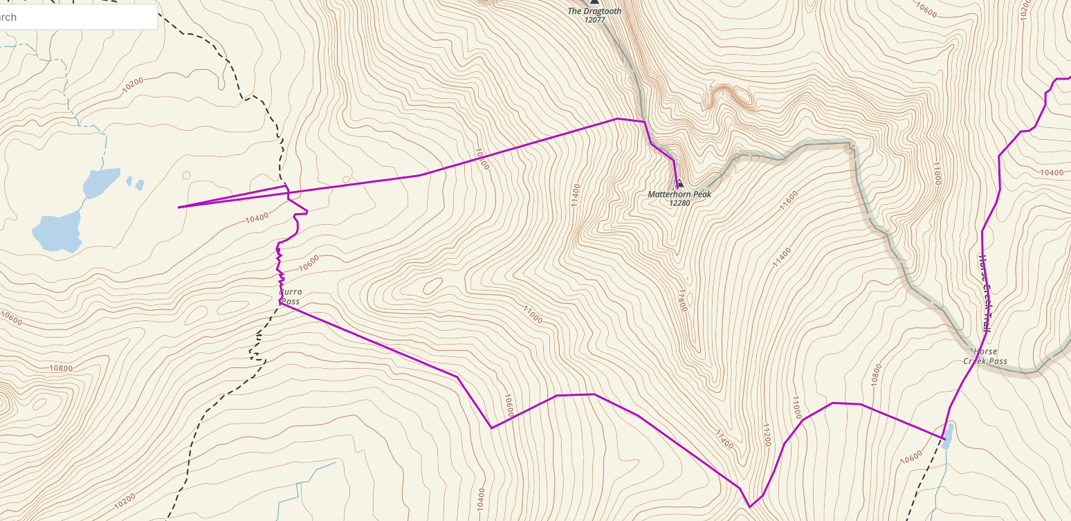
Here’s a detailed trip report going over Horse Creek pass starting at Twin Lakes outside Bridgeport. You shouldn’t need anything beyond a decent pair of trail runners as long as you’re comfortable on Class 2/3 terrain and on loose talus/scree and pick a decent route once over the pass. The linked report has some good beta.
I was just there a couple of weeks back – most of the creeks are dry so it’s wise to carry water.
There are also a couple of recent trip reports here on BPL but not as detailed.
 @gearmaker thanks for the feedback. I plan on carrying an emergency shelter, and if any weather signs appear we’re bailing. We are both pretty experienced, but my partner moreso. This post is to help me be prepared. I trust his intuition and will exercise caution. We are roping regardless of temps, this is a practice run for us as a climbing team, and for me to gain experience. He is a reliable 5.12 trad climber. We are going up the NW face.
WOW, GREAT resources. Thanks a bunch! I was struggling to find beta for this trip, especially water. We are going up Horse Creek pass, then traversing through the saddle between matterhorn and whorl (though I am not sure if we actually can) over to Burro pass, then hopefully camping at the tarns there, hoping for water, but carrying water like we’ll be dry. We were also hoping for water at the little tarn just on the south side of horse creek pass. We are going up the north west face route described on summit post.
If you’re considering going over Burro pass, the lake below Mule pass (on the Hoover Wilderness side) has water and of course Crown lake, Robinson lakes, also Robinson Creek and Barney lake all have water.
It might be worth considering doing the loop in the opposite direction: start on the Barney lake trail (from Twin lakes/Mono village resort), go up the to Crown lake and over Mule pass getting water along the way at Crown lake and maybe the upper small lake closer to Mule pass. Spend the night below Burro pass. Then follow the Burro pass trail to Burro pass. Leave the trail and drop down a bit as you traverse up to the saddle (aka “Matterhorn pass”) between Whorl mountain and Matterhorn Peak. Climb Matterhorn and exit over Horse Creek pass the same day.
Both the trails start/end at the Mono village resort. You’ll pay $15 to park your car at Mono village for upto a week.
Make sure you self issue a permit at the Bridgeport ranger station if you plan to spend a night or more in the Hoover wilderness or Yosemite. There’s a box outside the ranger station as they are closed for Covid-19.
Note: While the creeks on the Hoover wilderness side do have water (Robinson creek), EVERY creek on the Yosemite side was bone dry (as of two weeks ago). Even the smaller tarns were dry or very low with brackish water. The latest fire weather conditions the past few days have probably dried things out further, if that’s even possible.
I believe the small tarn lake just south of Horse Creek Pass, at the headwaters of Spiller Creek between Matterhorn Peak and Virginia Peak, has water year-round.
We’re comfortable with the trail on horse creek pass, or the lack thereof I suppose. Double the mileage is a lot, so I think we’ll stick with our current approach. But, that would be a good approach for a multipeak/day traverse. That’d be sick. Spoke with the rangers this week and heard the same message, so it sounds good. We’ll just plan to carry a lot of water, and if we decide we don’t want to go out the way we came, we can come down mule pass.
Thanks all for the info. Very helpful.
Have a fantastic trip! The weather looks awesome and you’ll have a great time. The short days with less than 10 hours of daylight is another thing to factor into your plans.
Please do report back with a brief trip report upon your return.
Become a member to post in the forums.

