Topic

Unexpected Snowstorm in the High Sierras: My Shoulder Season Lesson

Viewing 25 posts - 1 through 25 (of 27 total)
Mike S BPL Member
PostedOct 5, 2023 at 4:03 pm


Country United States
State California
Area Kings Canyon National Park
Trip Month (10) – October

Gear List

  • Z Packs Plex Solo tent
  • Z Packs Arc Haul Pack
  • Down Jacket with Hood
  • Sun Shirt with Hood
  • Patagonia Fleece Jacket
  • Two Wool Long Sleeve Base Layer Tops
  • Trail Running Shoes
  • Running Tights Bottoms
  • Two Pairs of Hiking Pants Treated with Permetherin
  • Therm-a-rest Neoair NXT XLite Sleeping Pad
  • Sea To Summit Micro McII Sleeping Bag Rated to 36 Degrees F ( I’d used this this setup
  • comfortably with heavy use of down to around 25 degrees)
  • Carbon Bear Can With Five Days of Food
  • Waterproof Shell Top
  • Altamira Two-Part Water Treatment Drops
  • Esbit Cubes
  • A Couple Pairs of Wool Socks
  • Garmin InReach
  • Waterproof Phone, and an iPad Mini, Both With Garmin Communication App, Maps, and Trail
  • Route
  • Headlamp and 2 Extra Sets of Lithium Batteries
  • Physical Map
  • Temperature Datalogger
  • Light Balaclava and Gloves
  • Nightcore PowerBank and Solar Charging Infrastructure

Report / Notes
Well, I had an unexpected epic that I hope not to repeat. I made some mistakes. I’m trying to learn from them and figured I might as well share my experience.

I’m an experienced solo backpacker…but my experience is in the summer, winter, or at lower altitudes at that time of year. People with more experience in the shoulder season in the High Sierras and other high-altitude areas will just roll their eyes.

I started on a planned five-day trip to Dusy Basin, Palisade Basin, and nearby areas in the Eastern Sierras of California. Probably 2/3 of the time I planned to be on-trail. The average altitude was to be about 11,200 feet with an 12,000 foot Bishop Pass I’d cross a couple of times. The first and last days were to be solo. I had other folks on the permit, but two had to drop out. My friend Andrew remained but had time pressures that limited his time there. He’d meet me the next day after I updated him on the location of base camp.

The forecast looked good. Cold at night – maybe 20 degrees F, but warmer each night. There was to be perhaps .3 inches of snow from the day before. Cool! I didn’t think was a good way to get a reliable forecast for the location and altitude I was going to, so used a station 20 miles away and 1000 feet lower, and adjusted three degrees for the elevation change.

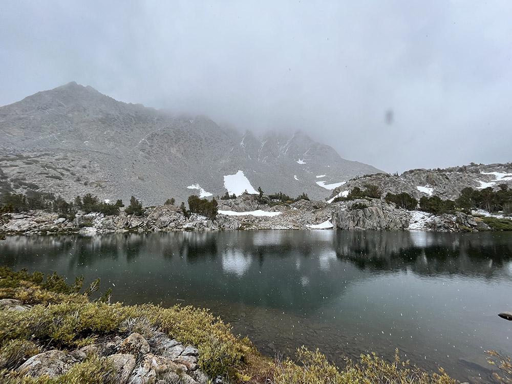
I left the trailhead with scattered ominous clouds and even saw a few drops of rain as I prepared to leave. FUN! I left my home in the SF Bay Area that morning where we don’t expect to see precipitation for months. This is the height of the summer there. The forecast looked good, right? I imagined the worst-case could be .3 inches of snow – the forecast for the day before when a little snow was expected. This day was supposed to be overcast, but dry. My gut was actually pretty nervous – it looked kinda gnarly. but was excited to get in. I silenced my gut voice.

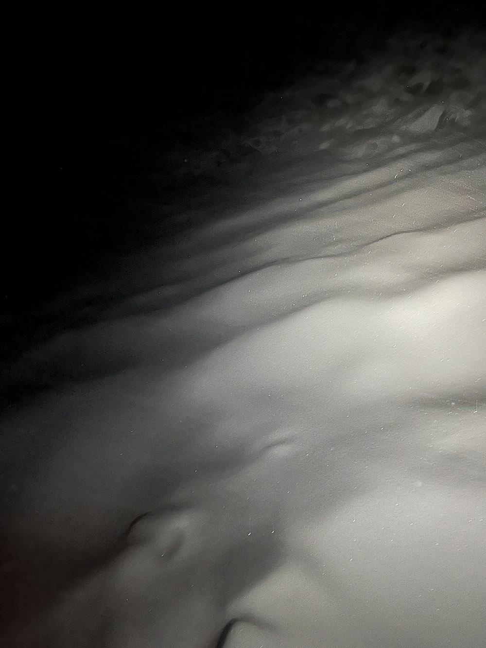
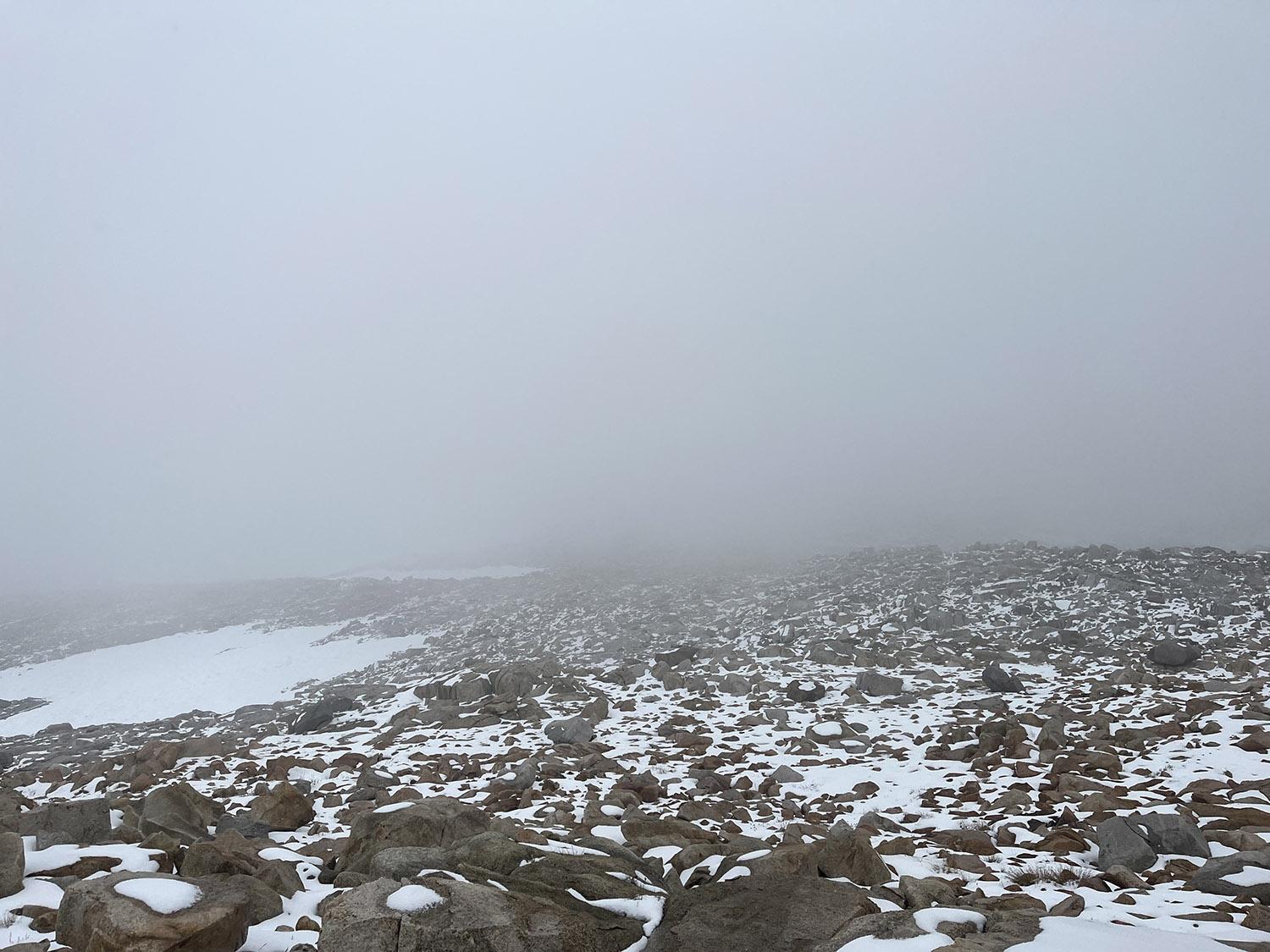
I started seeing snow-pellets halfway into the 7.5 mile hike from the trailhead. I wasn’t overly concerned. The climb was about 3.1K feet of elevation change and was mostly non-technical. However, the 1000 feet of icy, three-foot-wide sun cups in the snow at the pass covered with a little snow from the day before lacked any contrast in the overcast and low visibility. I don’t carry trekking poles except in the winter so there were some falls in there. No problem. I dropped into Dusy Basin. The snow pellets turned into heavy snow. The hike up had taken 4.5 hours and it was 6:00. Sunset was in 45 minutes.  I set up my tent, put on all my clothing, and got into my sleeping bag. I pinged my partner as well as the buddy who was to meet up with me the next day with with a Garmin Inreach. As I did so, the wind picked up. I checked the local forecast with the Garmin and got a “.3 inch of snow possible” response. But at that point it had already dropped 2-3 inches…in 15 minutes. I was getting pretty nervous. My gut finally got through from my subconscious to my conscious mind. I decided I didn’t come equipped for a heavy snowfall and I had no idea how much it was actually going to snow in this storm. I was concerned if I stayed overnight it might dump a couple of feet or more which would make trail-following back challenging.

Snow was blowing into my three-season UL tent through the mesh. I was already getting cold. Bad sign. No Bivvy. Not enough warmth margin in my sleep system. I was experienced with this system in the cold, and wet, but not with blowing snow that could lead to both. I figured I could hunker down and survive. I’d probably have to get up and move around from time to time since it was colder than I was prepared for. Would I get wet doing that? Probably. I could turn around and head back to the trailhead before the snow got too high. But that was obviously risky at night, right? I knew that I could physically do that in those conditions if I could stay on the trail. And not get injured. It would be a 15-mile day with about 6.2k feet of elevation change, but I was comfortable with that. But it was also going to be mostly in the dark and poor visibility. I didn’t have experience with that. I did have a map and compass and 2 devices with a breadcrumb trail I could reference for wayfinding. And I had a headlamp with backup lithium batteries that would work in the cold. And I knew I could stay dry and warm and do another 6 hours of hiking if needed in these conditions.

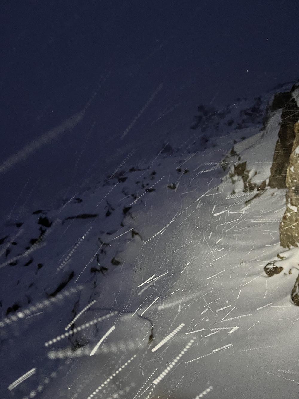
I chose to bail. I made the decision fast. Perhaps too fast. I notified my partner and my buddy who was planning to meet me the next day via Garmin, turned tracking on, and took off. When I got to the sun cups, they were already covered with a foot of snow. I fell several times which wasn’t fun at that altitude and in that context. My heart rate was in zone 3 for that whole section and closer on average to a mountain bike ride than a hike. I beat up my toe somewhere in the process, although I didn’t really notice it until the next day. I got turned around every time I fell in that snow field, and was pretty gassed out every time due to the altitude. At that point, I wasn’t sure I’d make it back, but I was too focused to linger on it.

After the pass and the more treacherous bits of the hike, I was pretty confident in success. But the path was getting tough to follow. I ended up checking my phone regularly to stay on the right track. It was running out of battery at that point, but it looked like I’d make it without recharging from my external battery if I kept up my current pace so I kept going. I finally got back to the trailhead at 10:00 at night, still dry and warm (except for my feet which were wet, but warm). I still had plenty of gas still in the tank (and my car’s tank). There was a foot of snow at the pass when I crossed it, and seven inches of snow at the trailhead. I bet there was two feet of powder at the pass by morning. I could have gotten through that the next day without snowshoes if I had chosen to hunker down, but I didn’t really know how much it was going to drop.

In my car, I plugged in my phone (that was almost out of juice) to top off and got a “your recharging slot is too wet for charging, dumbass!” notification which I didn’t know was a thing. I had a battery bank in my pocket if I needed to use it on the hike, but hadn’t known about the moisture problem even though I’d hiked with it in the rain and even snow many times before.

The road proved impassible for my vehicle, even with all-wheel drive, so I slept in my car. I was able to drive out the next day at 11:00 AM.

I made it out with a toe beat up from the ice field, and minor nerve damage to a thumb from the cold. I decompressed by camping in the nearby Alabama hills on BLM land in the Owens Valley 8,000 feet below with my buddy for a couple of warm, dry nights. I needed something comfortable and familiar.

It was 96 degrees inside my loft when I got home.

Where I failed:

  • I didn’t bail at the signs of unpredictable weather when starting the hike even though my body was uncomfortable with how different it was from what I had expected.
  • I didn’t adequately consider the likely margin of error for the conditions.
  • I hung my decision-making on bad weather forecasts.
  • I didn’t have enough margin for basic warmth and shelter.

What I learned:

Safety margins should correspond to the margin of error for the situation at hand. UL isn’t about cutting to the bone, it requires sensible reserves. Those reserves can be smaller only with experience in the specific scenario.

Just because you have a satellite communicator, and people know where you are,  help can take a long, long time in bad conditions. Don’t let a lifeline alter your safety calculation.
With lighting, trail-following at night wasn’t much harder than during the day. Snow cover is far more impactful.

Inform logical decision-making with gut feelings. I’m not good at this.
Invest in figuring out how to get usable weather forecasts for your specific location and altitude. It’s not going to be as easy as looking at wunderground, the closest weather stations, or other mainstream sources.

Traveling with other folks may not improve a bad situation, but might keep you out of it. More heads offer more opportunities for someone to veto dumb choices.

Consider logistics that allow for earlier starts from the trailhead, not just alpine starts from home when there’s a potential for poor conditions.

My feet were warm on the hike in trail runners even though they went through the snow into running water a couple of times. Boots might have kept me from banging up my toe, but I still think I’d add gaiters before I added boots in the shoulder season.
What saved my ass:

  • A headlamp with cold-rated batteries (had to be held off-axis by hand due to heavy snow in the air)
  • Known fitness and endurance
  • Devices leaving digital breadcrumbs to backtrack my path that had become covered with snow
  • Strategic clothing layering strategy that enabled me to stay dry

In the future at that time of year, I’d add these to my equipment list:

  • A two-wall tent and/or a bivy bag
  • Warmer gloves
  • Gaiters with Goretex trail running shoes
  • A warmer sleeping bag
  • Trekking poles
  • A high-powered stove like my MSR Whisperlite Internationale
  • A phone charging on the way in on an external battery (so it’s already fully charged if you need to bail)


Matthew / BPL Moderator
PostedOct 5, 2023 at 6:10 pm

It sounds like bailing was the right call and this is a good warning about having some margin of error.

Isn’t Bishop Pass around 12k, not 13.6k?

Bruce Tolley BPL Member
PostedOct 5, 2023 at 8:30 pm

Agreeing with Mike here.  I think you should add to your list of what saved your ass: making the decision to retreat early. Kudos to you.  Way too often we are stuck in the mindset of finishing the hike or making the summit.

There was a group of Scouts and adult leaders that facing an early Autumn snow storm got stuck up near Florence Lake in October in 2012 or so that hunkered down.  The powder that the storm dropped got so high that they were unable to travel. They had lots of food,  double-walled tents, and sufficient fuel but I recall it took perhaps 5 or 6 days before they were rescued.

The mountains make their own weather. We have to respect Mother Nature because she has no respect for us.

Bill Budney BPL Member
PostedOct 5, 2023 at 11:34 pm

The good news is that it makes a great story.

Could have been fun with snowshoes and a 4-season tent. Maybe next time.

I’m with you on redundant lighting, navigation, and batteries. It seems silly to skimp on those just to save a couple of ounces. The weight difference is nothing when the weather changes.

Glad you made it back with mostly just the story. Hope your thumb and toe recover well.

Paul S BPL Member
PostedOct 5, 2023 at 11:46 pm

Glad you made it out safe.

I’ve more than once found that the inReach weather reports are not very accurate. I tend to look at the weather, particularly in the fall, just before leaving for my trip and use multiple sources — plan for worse case scenarios and adjusting for altitude when necessary. e.g. mountain-forecast.com + NOAA  point forecasts + windy.com + wunderground, etc..

Having bail out plans and lower altitude “safe” camps is important.

A few years ago I sat and listened to trees all night, waiting for 1 to come crashing down during a mono wind storm. Won’t do that again.

nunatak BPL Member
PostedOct 6, 2023 at 6:45 am

For more context it would interesting to see a gear list

Jerry Adams BPL Member
PostedOct 6, 2023 at 7:23 am

on your inreach, if you send “wx now” to wx2inreach@gmail.com it will send you back the noaa weather report for that location.  That moment in time and that gps location which includes altitude

Paul Wagner BPL Member
PostedOct 6, 2023 at 7:40 am

Good job on getting out!

But how did you miss that forecast? My trail crew for those dates was cancelled because the weather concerns…

David Hartley BPL Member
PostedOct 6, 2023 at 7:45 am

Agree that gear list would be a great addition.

Disappointing that the inreach weather was so far off for your location. I have had better luck with inreach weather for eastern locations (NY Adirondacks, Smoky Mountains, etc.).  Thanks for the weather info tip Jerry – I will definitely add wx2inreach@gmail.com to my inreach contacts and “wx now” to my “quick” messages.

Dan BPL Member
PostedOct 6, 2023 at 7:59 am

Sounds pretty miserable, Mike, glad you made it out safely.

Jerry Adams BPL Member
PostedOct 6, 2023 at 8:41 am

wx now is one of my three, free preset messages

thanks to Doug for turning me onto this

Mike S BPL Member
PostedOct 6, 2023 at 1:25 pm

Matthew –  ” Isn’t Bishop Pass around 12k, not 13.6k?”

oh, you are right. edited.

Mike S BPL Member
PostedOct 6, 2023 at 1:26 pm

Jerry – “on your inreach, if you send “wx now” to wx2inreach@gmail.com it will send you back the noaa weather report for that location.  That moment in time and that gps location which includes altitude”


oh, this is great info. thank you.

Mike S BPL Member
PostedOct 6, 2023 at 1:38 pm

Paul Wagner –

“But how did you miss that forecast? My trail crew for those dates was cancelled because the weather concerns…”

Like I said, more experienced shoulder season people will roll your eyes. I didn’t know how off my weather resources were. Now I’ve got Jerry’s NOAA recommendation.

Chris K BPL Member
PostedOct 6, 2023 at 2:41 pm

Thanks for posting this as a trip report. Always valuable and interesting to read about the decision process in these scenarios. And glad you made it out safe despite the toe!

Jerry do you find the Garmin forecast often differs from the NOAA forecast to this extent?

Jerry Adams BPL Member
PostedOct 6, 2023 at 3:10 pm

https://wx2inreach.weebly.com/

“US forecasts are provided by the National Weather Service. Elsewhere they’re provided by VisualCrossing.com.”

It translates the forecast to abreviations that maximize the amount of information that fits into the 144 character limit of inreach messages, for example “Tn ChRnShw 44% 49 Tm ChRnShw 43% 60 TmN Cld 15% 47 Th RnShw 72% 55 ThN Clr 5% 45…”.  It gives the percent chance of rain and the max temp for days and min temp for nights.

It takes maybe an hour for it to reply.  It usually works but occasionally gives me gibberish.

Also on wx2inreach.weebly.com – “donate” – “It costs very little to keep this service going, but there are a few minor expenses. Any donations are much appreciated!”


jscott Blocked
PostedOct 6, 2023 at 6:24 pm

Mike, you’re still around to post this report. You did the right thing. Bravo!  Not an easy decision to make, hiking out at night over a snowed in trail.

As I recall, there’s a brief very sketchy stretch just below the pass, if there’s ice or snow.

The main take away for us reading this is, you recognized that you were under-prepared for conditions, and took drastic but appropriate steps to get out. It seems that your headlamp ended up being the real critical piece in all this! A good lesson.

Eric Kammerer BPL Member
PostedOct 16, 2023 at 5:33 pm

I’ve found that a simple charging-port dust plug will keep the moisture out of the phone and prevent those annoying moisture messages. Search Amazon for “USB c dust plug” (or USB micro, Lightning, etc.).

PostedNov 5, 2023 at 11:17 am

My Ludite assessment is an over-reliance on technology. Cloud forms, temperature, and relative humidity- all deduced from observation and “feel” are sounder predictions. A more snow shedding tarp, ground cloth, and a sleeping bag rated to single and/or below zero digits would be better. With a tarp you could also build a warming fire. In any hinge season, I pack like Colin Fletcher did, wool trousers, plus poly long johns, I like hiking solo too, but with weather on the horizon and walking a new route, I’d have two more buddies presuming the same fitness level. I’ll also take a shot at this hiking with sneakers gambit. It’s designed by the shoe companies to get you to buy more of their products. I wear leather boots- same two pairs that are two-three decades long. I hike fifty miles a week. Two have been re-soled twice. Wet and snowy weather soak through nylon (consider your tent) real fast. The Marine Corps infantry officer in me recalls the plight of cold and wet feet on the march. Good luck a thanks for the courage in sharing lessons learned.

PostedNov 5, 2023 at 4:34 pm

Great trip report. This got my heart rate up just reading it.

I wanted to mention how helpful checking meteoblue.com for the historical weather extremes for the time and place is. It’s nice to know the historical worst case scenario when planning against the forecast. Also, they have very detailed forecast info and can extrapolate between weather stations.

One other thing comes to my mind about your story. If you had fallen in the snow and injured yourself on the return trip would you survive the cold/wet? Given how easy it is to sprain or break something in the woods it always seems like a good idea to bring enough warmth that if stuck I won’t freeze to death.


PostedNov 6, 2023 at 6:22 am

Very well done to Mike for managing himself in a difficult situation, and thanks for sharing – really helpful to be reminded of pitfalls and the difficulties in thinking through in advance the range of potential unanticipated problems and difficulties to be considered. One thing not mentioned in your article, Mike, is your rehydration and calorie intake during your trip down the mountain. Really easy (for me, anyway) to forget or at least minimise the importance of these in a crisis when the survival urge is to press on regardless.

NFN Scout BPL Member
PostedNov 6, 2023 at 7:22 am

After the hassle of a few kayak trips where my phone port too wet to charge, I started to carry a few strips of thin electrical tape around on my phone case. Now if the phone could get wet, I cover the charging port up beforehand with the tape, works a treat. Just peel if off when you want to charge.  Hack to protect phone port from water

PostedNov 23, 2023 at 8:19 pm

I’m 80 now so I have to remember that my endurance is about half wha it was when I was CX ski racing and patrolling in my 40s.

->A SPOT beacon always goes with me now, even on day hikes in Nevada’s mountains.

->I chose my SUL Dyneema TT Notch Li (“solid interior”) for its ability to handle snow better than most other solo Dyneema designs and still ventilate enough to keep me dry(er) than most.

->My WM Megalite overstuffed mummy has been good to 15 F. with a light base layer and light balaclava but with my down vest of jacket and day pants it would likely go to almost 0 F. , even with a 3 season REI FLASH insulated mattress (R 3.2) Inside the Notch Li solo tent I get another 10 F. of warmth.

-> A pair of low ripstop GTX gaiters will keep snow out of my boots, which have a “WPB” laminate (for shoulder seasons).I also carry a pair of 3 mm thick neoprene divers’ socks and thin  poly liners if there is even a chance of unseasonably cold weather. This keeps the inside of my boots dry(er).

->Light GTX mitten shells and light fleece gloves are packed as well.

That’s about all I’d need UNLESS the snowfall was moe than 10″ deep. More than that and I need to pray and/ or push the SHTF button on my SPOT beacon.

Donald C BPL Member
PostedDec 3, 2023 at 1:30 pm

I myself ran into much the same conditions back in 2015, the first week in October. I was on my way back from a loop out of Edison Lake over Goodale Pass on down to Iva Belle Hot Springs and decided to take the Fox Meadow trail up out of Fish Valley to drop into the Silver Creek drainage and go up and over Saddle Mountain Pass. I followed the drainage up to timberline at Fern Lake, set up camp for the night and the next morning I awoke to a snowstorm that had already dropped about 3 inches. Visibility was about 20 feet but the trail was well worn and I followed it up and over Saddle Moutain Pass. I did get lost and attempted to continue up over talus the size of pickup trucks till I realized in this storm I would die in the talus before I reached the top. I had to backtrack a mile or so and found a navigable chute up out of the deadly snow covered talus. I made it to the top of the pass and as soon as I crossed over the skies parted and the snow turned to rain. I had adequate raingear and made it down the trail to my car parked at Vermillion Valley Resort. There was one employee left buttoning everything up and he told me if I hadn’t shown up by the time he left the next day he was going to call search and rescue. My first dicey trek but unfortunately not my last. I had another 2 years later after botching a creek crossing on Granite Creek up in the Ansel Adams wilderness, (too early this time, so much snowmelt) but that is another story.

Grant T BPL Member
PostedDec 4, 2023 at 8:48 am

Just want to say thanks for posting. A great cautionary tale

Viewing 25 posts - 1 through 25 (of 27 total)
Loading...