Are paper maps going the way of the dodo? I am finding it increasingly hard to find decent maps for trips. The Forest Service Maps don’t have topo lines and are in a scale that has very little detail. The National Geographic maps are great but limited to a handful of areas in my state. Do I need to learn to use mapping programs and GPS devises? I am very happy with a good quality map. I am not very comfortable with computers and the idea of having to rely on them in the bush, not to mention the weight and expense. I am willing to learn new things, I just don’t want to spend endless hours on my computer instead of backpacking if I can help it. I looked at CalTopo and found the trails on the map in my area to be inaccurate. What would you guys recommend for someone like me in terms of trip planning and navigation?
Topic
Trip Planning and Navigation in the Modern Era?
Become a member to post in the forums.
- This topic has 13 replies, 9 voices, and was last updated 7 years, 11 months ago by .
You can buy USGS topo maps online and at many fine retailers. You can also download and USGS topo map from their website and take the file to places like Kinkos or Staples and have them printed. This is as modern as I get and what I usually use.
Nick,
I used to use USGS quads until they became so outdated as to be unusable anywhere there were roads or trails and not dealing with purely natural features. They were published in the 70’s.
Have they updated the information on these maps?
Do the maps you are referring to have trails on them, as I don’t see any when looking at them on the USGS site?
I use acmemapper.com to print out maps in exactly the scale I want. I also take along a larger map like NatGeo or Tom Harrison, so I can identify those peaks over there on the horizon…
Adrian, There are many different types of layers available on Caltopo. You might try different layers and see if you are happier with the trail coverage.
I used to use USGS quads until they became so outdated as to be unusable anywhere there were roads or trails and not dealing with purely natural features. They were published in the 70’s.
Have they updated the information on these maps?
Do the maps you are referring to have trails on them, as I don’t see any when looking at them on the USGS site?
Yes, they have trails on them. Use this link to start your search. It takes a little bit of practice to play around with the available maps.
https://ngmdb.usgs.gov/topoview/viewer/#4/39.98/-100.06
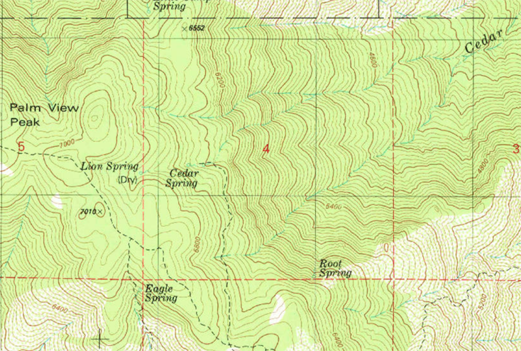
What is kind of neat is there are older versions of maps available (sometimes you can find an old trail that is no longer used – my kind of hiking). So here is an example from two maps I just now looked at on the USGS website:
1982
Palm View Peak, CA (1982 edition)

Take a look at a couple of things in the picture above. On the very left edge there is a red 5. This is Section #5. Just below the 5 is a trail heading south; this is the PCT. If you follow the PCT south, you will see there is a junction to a trail that leads to Cedar Spring. It is a little confusing because the PCT veers to the east of Eagle spring. The USGS should differentiate major trails (so I can avoid them ;-)
Keep both of these in mind: the PCT and Cedar Spring.
As a side note, Cedar Spring was an important water source for PCT thru-hikers until this section of trail was closed a few years ago due to the Mountain Fire. I think it may have been officially opened this year.
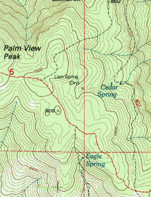
1996
In 1994 a trail was completed from Cedar Spring down into the Aqua Caliente Indian Reservation on the desert floor. This trail, the Jo Pond Trail, isn’t well known or used very much. So, let’s see if the USGS updated the map. The latest Palm View Peak, CA map is the 1996 version. See below:
Palm View Peak, CA (1996 edition)

Lets take a look at the Red #5. Notice <span style=”color: #ff0000;”>the PCT is now red</span>. Hurray.
Now look at Cedar Spring, and you will see the trail now continues past the spring going north. This is the Jo Pond Trail that was just completed two years before the map was issued.
I can’t say this happens all the time, but I have been very happy with USGS 7.5′ maps and have been using them for almost 50 years. No need for me to change, learn a new system, or spend money on electronic devices. Of course others may prefer something else.
For those who are interested, here is a blog post I wrote about some inconsistencies in USGS topo maps.
and for fun,
Set Up Your Compass Faster & More Accurately With A Map Protractor
Set Up Your Compass Faster & More Accurately With A Map Protractor, Part 2
How to Orient Your Map Quickly With a Compass
Adrian,
Caltopo has many different map layers from which to select. For example, I normally choose either the USGS or FS topos, but sometimes might choose another as needed.
The USGS map store (https://store.usgs.gov) allows you to see the various quads available and download them for free as PDFs. As part of the process, you’ll see that various maps are available for a given area. You can choose from the old-school maps from the 70s (or earlier) but should also see maps from the current century, as well as some in between those periods. The newest ones are assembled from various GIS datasets and have a noticeably different look to them. Unfortunately this newer generation often omits trails, which is why I often check the FS Topo layer in Caltopo.
Good advice from @requiem who is very knowledgable about maps and navigation. I tend to hike off trail, so the lack of trail information isn’t important to me most of the time.
Caltopo is probably the best source to use.
Yeah, the trails that are marked on the USGS quad layer are woefully outdated, so don’t trust them. But I do trust the topo lines, mostly.
There is a feature in Caltopo that allows people to import their GPS data and share it publicly, which is very useful for finding accurate trail info. If you experiment with different layers, hovering the pointer over these user-created paths will highlight them (the map builder layer seems to have a lot of them). You can then copy or trace them onto your map. I then switch back over to the USGS quad or USFS layer, to use the topo lines, but now my trail is layered on top. I like to double check these trail lines by zooming in on satellite view and making sure I can actually see the trail at several points.
Then I chose “print map” and send it to FedEx Office to print. About $3 per double sided page for 11×17. Andrew Skurka shares the printing details on his site:
https://andrewskurka.com/2015/printing-exporting-topographical-maps-from-digital-sources/
I believe Caltopo now charges a nominal membership fee if you want to print larger then 8.5×11, but I’ve found it well worth the money. There’s a learning curve here for sure, but the reward is highly customized maps for a little cheaper then what you might otherwise pay, available for any area you want.
Paper maps and paper map sets will always be in use. Digital is great if one can maintain the needed signal via cell phone signal, but it seems there’s less coverage in certain rural areas with certain carriers. There’s satellite but it’s expensive (waiting on my lotto winnings). Plus the electronics may fail (last year a PCTer made the national news after losing all his gear falling into an overflowing river), .. so I’d want some sort of paper map back-up in many cases.
Last I heard “digital” still cannot substitute for properly surveyed paper maps in a final legal sense, though there’s plenty of (neat) digital applications. So the base maps will always be found somewhere. Now finding the desired paper maps may be a challenge and if needing to print, there’s the associated costs of colored ink, etc…
Thanks for all the advise guys.
“Digital is great if one can maintain the needed signal via cell phone signal, but it seems there’s less coverage in certain rural areas with certain carriers.”
I’m probably misunderstanding you, but you don’t need a cell signal to use your phone as a gps.
I use Gaia on my iPhone, so I use the Gaia website on my Mac to plan trips. Like CalTopo, you have a variety of map overlays from which to choose. I haven’t used CalTopo so I don’t know if it includes this feature, but one of the things I like about planning on Gaia, if using trails, is that you can click to start your route at the beginning of the trail, and then click somewhere much further down and the program automatically draws the line along the trail instead of a straight iine from one point to the other. A lot less clicking this way to map out a route.
Caltopo does everything you need a GPS software to do, free. Generate elevation profiles, create a route with a few clicks on established trails or many clicks off trail (definite your own route). Also you can save routes under an account for sharing to others with links.
You can add maps as layers – say a USGS quad over a FS map — and adjust the transparency of the maps until both layers are visible.
You can add icons to show your friends where your intended campsites will be. Color code each day’s intended hiking in any color you like. Join or split a track you’ve added. Delete sections.
Printing sections of the map to your printer or to a pdf is pretty simple, and all the data you need (declination, scale, etc) is printed in the margins. If you want a larger map than you can print, save to pdf and email it to Office Depot – it will cost some money but you can print color maps on various paper stock. I’ve done it for trail crew trips. We share back and forth detailed maps on CalTopo of the work we’ve done, classifications for all the trails we work added in so we know how far off the trail we need to cut the logs, label/prioritize, and before the trip the section map gets printed and handed out to the volunteers.
Become a member to post in the forums.