Topic
The old Pioneer trail…
Forum Posting
A Membership is required to post in the forums. Login or become a member to post in the member forums!
Home › Forums › Campfire › Member Trip Reports › The old Pioneer trail…
- This topic has 4 replies, 2 voices, and was last updated 5 years, 4 months ago by
 Paul Wagner.
-
AuthorPosts
-
Nov 13, 2018 at 1:58 am #3563805
<table class=”sites-layout-name-one-column sites-layout-hbox” cellspacing=”0″>
<tbody>
<tr>
<td class=”sites-layout-tile sites-tile-name-content-1″>
<div dir=”ltr”>
<div>
<div>
<div>
<div> </div>
</div>
</div>
<span style=”font-size: medium;”>With our youngest daughter in town, we headed up to our cabin near Sonora to get some cleaner air and hopefully to a little hiking. The air in Napa has been so bad that we haven’t been out much at all, on a bike or on foot. It has been truly miserable. </span></div>
<div><span style=”font-size: medium;”> </span></div>
<div><span style=”font-size: medium;”>But we were happy to see that the air in Twain Harte was much better. And so on Saturday we drove up towards Sonora Pass to see if it continued to improve as we went uphill. It did. And we took the opportunity to do something we had wanted to do for a long time.</span>
<div></div>
</div>
<div><span style=”font-size: medium;”> </span></div>
<div><span style=”font-size: medium;”>Every time we drive along Highway 108 below the pass, we note the remnants of the old Pioneer trail that brought early immigrants into Tuolumne County over Sonora Pass. And we’ve always wondered exactly where it went, and how we could follow it. Saturday, we found out. </span></div>
<div><span style=”font-size: medium;”> </span></div>
<div><span style=”font-size: medium;”>Parking just above the 8,000 level on the highway, we crossed the creek and clambered up the slope to the obvious traces of the old road. From there we followed it East towards the pass, until we finally lost it in a sea of alders. But as we climbed up above the alders to get a better view, it was clear that the old road continued through the alders and across the creek, to head up the pass underneath the existing highway. </span></div>
<div>
<div></div>
</div>
<div><span style=”font-size: medium;”>Cool. </span></div>
<div><span style=”font-size: medium;”> </span></div>
<div><span style=”font-size: medium;”>And then we went back downhill and followed it in the other direction for a while, until it did the same thing at that end, crossing the creek to avoid some steep granite, and getting paved over by Cal Trans. </span></div>
<div><span style=”font-size: medium;”> </span></div>
<div><span style=”font-size: medium;”>It was an interesting hike. And while we didn’t find any truly historic treasures, we did get a sense of how much work went into building this old road. Some of the stonework was still visible today. The air was clear. The scenery was stunning. </span></div>
<div><span style=”font-size: medium;”> </span></div>
<div><span style=”font-size: medium;”>And we got to spend some quality time outdoors with a wonderful child. </span></div>
<div><span style=”font-size: medium;”> </span></div>
<div><span style=”font-size: medium;”>A very good day indeed. </span></div>
<div><span style=”font-size: medium;”> </span></div>
<div><span style=”font-size: medium;”>the rest of the photos from this trip, as well as the hike the following day, are here: </span></div>
<div><span style=”font-size: medium;”> </span></div>
<div><span style=”color: #0066cc; font-size: medium;”>https://photos.app.goo.gl/bjSdN25VZMNhJM5PA</span></div>
</div></td>
</tr>
</tbody>
</table>Nov 13, 2018 at 1:59 am #3563806God I love this forum software.
Nov 13, 2018 at 3:09 am #3563810Paul –
Back in the early 80’s a buddy and I did a hike around the Sonora pass area (I forget exactly where) but I recall we were following a bad trail down a steep canyon and we came across a wagon wheel mounted on a granite slab with a plaque that read (if I remember correctly) “Williamson party”, followed by the year, which was sometime in the mid 1800’s. We looked up the canyon, then down, then at each other and said “Wow… they did this with WAGONS?!!” Tough as nails, those pioneers.
Nov 13, 2018 at 2:42 pm #3563861After heading up to Sonora Pass, we decided we’d hike where the weather would be a bit warmer the next day. And since we had fun following the old pioneer trail yesterday, today we took the West Side Trail from River’s End on the Cherry Lake Road back towards the town of Tuolumne.
<div>
</div>This trail begins with a steep but short climb from the road up to the old railroad bed, and from there on it is almost dead flat. There were a couple of gullies that required us to climb up and down a total of maybe fifty feet because the trestles were no longer safe, but other than that, this was a cakewalk.
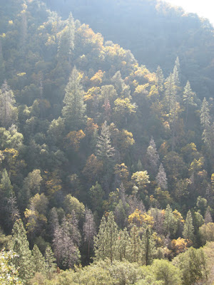
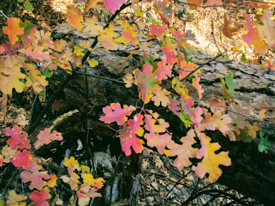
But that didn’t mean it wasn’t lots of fun. We rolled along at a good pace, and covered about seven miles in our afternoon walk. We found a nice spot for a picnic, read a few educational signs, and really enjoyed the fall colors and the cool autumn air.
This trail in the spring can be quite hot—but it also has loads of wildflowers. In the fall it was a completely different experience. And we saw a total of one person, a lonely mountain biker, during our three-and-a-half hours on the trail. Pretty nice
<div>
Dec 10, 2018 at 5:44 pm #3568330Since we’re in the neighborhood…
This Sunday I decided I had to get up into the mountains, and took advantage of an invitation to work on the Hite Cove trail with a group of local volunteers. For those of you who don’t know, Hite Cove Trail runs along the South Fork of the Merced from Savage’s Trading Post up to Hite Cove itself, where there are some relics of the gold mining era, and then continues as a rough route all the way up to Wawona.

Savage’s by the way, has an interesting role in the history of Yosemite. It was originally a trading post owned by Mr. Savage, who enjoyed a relatively comfortable relationship with the local native Americans. Then things got ugly, he got killed, they got attacked and confined….well, it wasn’t the best part of our local California history. But it was important.
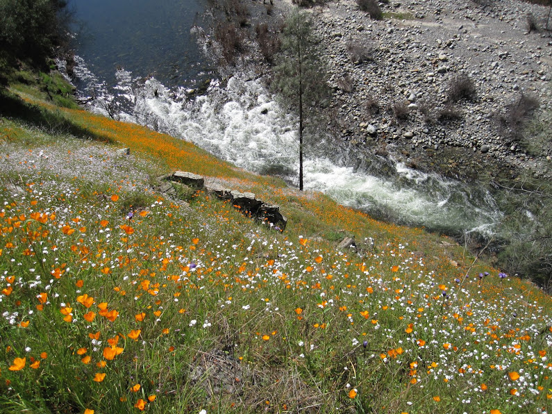
The Hite Cove trail is most popular during the spring, when the wildflowers can be simply stunning. But this time of year, it has a very different character, particularly after the huge Ferguson Fire raced through this area. The hope is that the fire will open the door to a particularly large wildflower explosion this spring, and we’d like the trail in good condition when that happens.
At the same time, the fire opened up the tree cover so that there are more views along the canyon, and the geology in particular is more apparent.
As has always been the case, I really enjoyed meeting the trail volunteers and working with them. They have a deep appreciation for the whole region and lots of stories to tell about their own experiences as well as those of others who’ve hiked here. It was a good day, and we got a lot done on the trail.
Here’s one more photo, of what the poppies can look like in the springtime along the Hite Cove Trail:

Here’s the link to all the photos:
-
AuthorPosts


- You must be logged in to reply to this topic.
Forum Posting
A Membership is required to post in the forums. Login or become a member to post in the member forums!
Our Community Posts are Moderated
Backpacking Light community posts are moderated and here to foster helpful and positive discussions about lightweight backpacking. Please be mindful of our values and boundaries and review our Community Guidelines prior to posting.
Get the Newsletter
Gear Research & Discovery Tools
- Browse our curated Gear Shop
- See the latest Gear Deals and Sales
- Our Recommendations
- Search for Gear on Sale with the Gear Finder
- Used Gear Swap
- Member Gear Reviews and BPL Gear Review Articles
- Browse by Gear Type or Brand.
