Sound and Silence: A Return to Bear Lakes
The Reset
I completed my last big hike with two threads to weave: a “life search” to chart a course for active retirement, and solving the physical “ass‑kicking” the Sierra had just handed me.
Progress on both fronts is good, though much work remains before I can see the whole cloth. My goal now isn’t to produce a brand-new fabric; it’s to weave a tapestry that reflects a life well-lived, the richness of family and friends, and honors the grace of God. There are disruptions, like my sudden retirement, where I’ve had to pick up new threads. There are repairs where I’ve torn relationships and stitched them back together, and there are still a few unpatched tears. But retirement, so far, is wonderfully active: morning workouts, consulting, a family reunion in Cape Cod, and frequent trips to see the grandkids.
Physically, my doctor determined Sarcopenia delivered last year’s ass-kicking. The prescription was simple but demanding: more protein, creatine, and heavy lifting. My leg swelling was venous reflux – now surgically corrected and ultimately more of a nuisance than the root cause. Nine months into this regimen, I’ve turned my strength clock back fifteen years, and aerobically I’ve never been fitter. With the physical noise finally quieted, I was ready to return to the mountains to see what else I could hear.
The plan
With this rebuilt foundation, I mapped a route that would have broken me a year ago: twelve days, 125 miles, half on-trail and half off. At its core, I wanted to revisit the Bear Lakes loop my friend Art and I completed in 2011, while adding new lake basin explorations on both the “Evolution” and “Bear Lake” ends, and one walk back in time.
My planned itinerary:
- Start at North Lake, over Lamarck Col, camp on Darwin Bench
- Descend to Colby Meadow, cross Evolution Creek, hike into and camp at McGee Lakes
- Cross McGee Lakes Pass North, dayhike to Muir Pass, return to Wanda Lake, cross Davis Lake Pass, camp at Davis Lakes
- Descend Davis Lakes outlet to the Goddard Meadow trail, north to JMT, camp along the S. Fork San Joaquin
- JMT north to Marie Lake
- JMT north, descend Bear Ridge Trail, cross Edison Lake dam, camp/resupply at VVR
- Ascend Mono Creek Trail to 2nd Recess, camp at Upper Mills Creek Lake
- Cross Gabbot Pass, descend to and hike around Lake Italy, ascend White Bear Pass, camp at Black Bear Lake
- Traverse Bear Lakes Basin, cross Feather Pass, descend to Merriam Lake and French Canyon, ascend to Pine Creek Pass, camp at Royce Lakes
- Traverse Royce Lakes, cross Granite Park Pass, camp in Granite Park, dayhike to Italy Pass
- Descend to Honeymoon Lake, cross Pine Creek Pass, descend to Elba Lake, ascend to Puppet Lake, cross Carol Col, camp in Humphrey’s Basin
- Traverse Humphrey’s Basin, visit Mesa, Desolation, and Lower Desolation Lakes, descend to Piute Pass Trail, cross Piute Pass, finish at North Lake
I didn’t hold to this exactly, but the changes were driven by terrain, weather, and campsite suitability; not physical limitations.
The Trek
Day 0 – Aug 30 640 miles driving
I drove from my home near Phoenix to Mammoth Lakes; the “bougie” plan where I stay at elevation in a hotel bed and eat restaurant food rather than camp at the trailhead. My route went through Las Vegas, across Death Valley, then up the 395.
On the way to Vegas, my A/C started cycling on and off. Then, crossing Death Valley, my fifteen-year-old car threw an occasional overtemp light. Shutting off the A/C made it subside, so I just drove hot. I didn’t suspect a coolant leak. Little did I know.
I arrived in Mammoth around 4pm, checked into my hotel, walked to a nearby restaurant, and wandered through a gear shop along the way. Belly full, I returned to my room, thought nothing more of the car, and retired for the night.
Day 1 – Aug 31: Bishop to Darwin Bench 50 miles driving 8.5 miles hiking

Temps were in the upper 40s as I cruised toward Bishop, but that damn overtemp light flashed again. I pulled into a service station. A flashlight check under the hood revealed a bone-dry, stained coolant reservoir. I dumped in half a gallon, hoped for the best, and headed for the trailhead. I couldn’t help but appreciate the irony: last year my body was breaking down; this year, it was the car.
After a quick breakfast at Jake’s and a brief detour to drop a hitchhiker at South Lake, I secured the car at North Lake, sent my inReach ping, and hit the trail. At the trailhead board, a couple from Seattle fleeing wildfires asked for advice. I pointed out that the map only covered a few miles, shared some favorite spots, and told them, “The best campsites are the ones that speak to you.”
Soon I reached the Lamarck Lakes junction, turned left, and followed the road less taken. It’s a fitting entry; it gets right to good stuff, and navigating life on the spectrum has always felt like the road less traveled, and for me, it has made all the difference.

Lamarck Lakes Trail: the road less traveled
I eased into a rhythm. I was testing a new pair of Altra Experience Wild 3+ shoes – having abandoned Brooks Cascadia’s as they’ve gone too “super-Hoka”- and paid close attention to my feet. But more importantly, I paid attention to my legs.

I navigated through a dozen guy-lines to get this picture of Lower Lamarck Lake
Lower Lamarck Lake was a tent city of at least ten tents. A large group was fishing and scouting the route to Lamarck Col. Watching a few of them return from the top of the switchbacks satisfied they had the route pegged, I couldn’t help but think of Tolkien: but they were all of them deceived. They’d reach the base of the pass easily enough but had no idea about the crumbly mess waiting at the summit.
I pushed into the gully leading to the col. The tarn was dry and the snowfield reduced to a patch, leaving 150 feet of stable talus and 50 feet of sheer crumbly mess. I gnawed my way to the top. While I felt light-headed and slightly nauseous from the altitude – standard day-one stuff – my climb was strong. Last year, the big Day 1 climb drained me completely. Today, the Sarcopenia was undeniably gone. I was pushing up a challenging route, and my rebuilt body was humming.
After a ten-minute snack at the top, I started down. Darwin Lakes came into view and did not disappoint. I followed the use-trail along the north side, relieved when the granite ramps and meadows finally opened toward Darwin Bench.

Darwin Lakes coming into view
 but closer is better
I arrived at Tarn 11200 around 6pm. After checking in with a nearby hiker to make sure I wasn’t crowding him, I found a gravel patch overlooking the water, set up camp, and settled into my camp chair. Oh my, was this nice. I gathered my bear can and cookset, and cooked my water, tucked dinner under my puffy to rehydrate, and just let the view soak in. (The advice from the three people I met on my last Mazatzal overnight regarding bringing a chair had not been oversold).

My camp on Darwin Bench. Yes, it was nice.
As the sun set, I joined three other hikers on a high point overlooking Evolution Valley. They turned out to be off-duty NPS employees. We traded beta as the light faded—they shared route details for my push into McGee Lakes tomorrow, and I offered beta on Ionian Basin.

Where I received beta on McGee Lakes
At dark, the cold chased us back to our tents. I burrowed into my sleeping bag and let out a long sigh, fully satisfied. I was tired, but it was a good tired. My body was holding up its end of the bargain, and I was ready for tomorrow’s off-trail push.
Day 2 – Sep 1: Darwin Bench to McGee Lakes 5.5 miles hiking

I wake to wind. It had settled shortly after sunset, but at daybreak, it resumes. It’s cold, frost lines the tent ceiling, and my sleeping bag is damp with condensate. If I didn’t have to pee, I’d roll to my side and try for another nap. I do my business and eventually drift back to sleep.
I wake again to the rustle of other people packing. Not ready to embrace the cold, I stay cocooned and think about the day ahead. McGee Lakes is new territory for me. The mileage will be short, the route straightforward, and there’s the possibility of blueberries along McGee Creek. Yesterday’s NPS crew had offered one specific piece of beta: stay left of the creek on the climb to the first lake.
By 7am, I crawl out into the freezing wind, wearing every layer. I sit in my chair with my back to the gusts and make breakfast – coffee and cold granola with milk (though as I crunch, I make a mental note to try it hot next time). With no morning sun to burn off the frost, and my arthritic right-hand joints aching in the cold, I am forced to pack up damp. A problem to deal with this afternoon.
I start the descent toward Evolution Valley. Halfway down, I lose the use-trail, but follow a series of granite ramps and short scrambles down to the JMT. I turn right, greet a couple of day-hikers heading up into Evolution Basin, and then I have the trail to myself. Around 11am, I can look straight up McGee Canyon. I step off the JMT and into the unknown.

Cross here and head toward the low point
The right side of McGee Creek looks much more amenable than the left – clean slabs and thin forest above a bog. Reaching the base of the climb, I decide to disregard the rangers’ advice to stay left. Trusting my own read of the terrain, I ascend an easy line on the right that tops out just twenty feet above the lower lake. I drop down, cross to the left side of the creek, shed my pack, and take a well-earned break. I send an inReach picture, enjoy a snack, and drain a liter of flavored water. Clear skies, bright sun, cool temperatures, and a light breeze. Perfect.

The first McGee Lake: resting here
Eventually, it’s time to move on. I follow a gentle line, moving slowly, taking time to let this new place soak in. It’s lovely here, feeling wild and lightly traveled—a pristine quality I intend to respect. I wander past a few tarns and a “middle” lake before crossing an isthmus to set up camp, boasting views of both the upper and lower lakes.

The Upper McGee Lake: I’ll camp here
Arriving mid-afternoon gives me plenty of time to lay out my damp morning gear, bathe, do a little laundry, and finally sink back into my chair to bake in the afternoon sun. Far from the traffic of the JMT, the ambient noise of the trail fades away. Sitting and warming, my mind stills.
Day 3 – Sep 2: McGee Lakes to Davis Lakes 10 miles hiking

I laze in the warmth of my sleeping bag until I am blessed with early sun. I lay out the bag, wipe down the tent, zipper it open to “bake out,” and set about breakfast. Granola and cold milk again – a missed opportunity to try it hot.
I’m in no hurry, giving my gear ample time to dry before packing. Nine a.m. is a late start, but starting warm and dry beats packing damp and having to peel layers thirty minutes down the trail.
Near the base of McGee Lake Pass North, I pause and scan. Left, right, or straight up the gut? My debate ends when I spot three people descending the gut. I meet them at the bottom and thank them for simplifying my route-finding. They’re base-camped at Sapphire Lake, out to summit the Hermit and maybe Mt. McGee. They tell me I’ll find a use-trail to the top, and to stay “further right than I might think” on the descent.

McGee Lakes: remember to look back from where you came
I reach the top quickly, breathing easy, and survey the glory of Evolution Basin. I follow their advice—keeping right, right again, and after a short slide, even further right. Soon I’m on a broad shelf at ~11,400 feet, and from there it’s an easy scramble to the JMT above Sapphire Lake.

Surveying the glory of Evolution Basin
It’s only 11am, so I decide to drop my pack and reprise the Muir Pass dayhike Art and I made on our 2011 Bear Lakes Loop. Trail crews have rerouted the JMT away from the Wanda Lake shoreline. The new trail is beautiful hardpack. I wonder how long it takes to build two-thirds of a mile of new trail, and whether this reroute avoids the early-season mosquito and gnat swarms of the old one.
The wind picks up on the ascent to Muir Pass, the gusts strong enough to knock me off balance. I persevere and am greeted by a ten-mule pack train at the summit. I ask for, and am granted, permission to walk between the animals and take refuge in the hut. I sit down to shake off the cold, marveling that even with the wind and the elevation, I feel good. Last year, Day 3 destroyed me.

Do these vent through the chimney?
I’m soon joined in the hut by Nate, a northbound JMT hiker who started at Kennedy Meadows to “ease into the elevation.” He admits there were moments he questioned that choice, as water was scarce until Rock Creek. He’s from Rhode Island – first Sierra hike, first time at elevation – taking a full month between jobs before moving to New Hampshire.
I make good time returning to Wanda Lake. I meet two guys setting camp near the outlet; more first-time Sierra hikers going “all in.” They had entered at Lamarck Col (evidently the two I saw camped between the first and second Darwin Lakes) and tomorrow they plan to dayhike over Black Giant Pass into Ionian Basin. I wish them luck, happy that the wind has finally relaxed to a gentle breeze.
Leaving Wanda Lake behind, I begin a walk back in time. If memory serves, it was 1972 when my Boy Scout troop camped at Davis Lakes on our North Lake to South Lake loop. I cross the Wanda Lake outlet, walk a short distance along the shore, and the memories lock into place.
First stop: The Outlet. In ’72, another troop was camped near the outlet. Their leader was washing breakfast cookware directly in the lake, scrambled egg floaters drifting everywhere. Our Assistant Scoutmaster, Revon Wolf, gave us a master class in confrontation. He grabbed that leader by the collar, turned him around, and said, “What the hell do you think you’re doing?” As we hiked out, they were gathering water and scrubbing their cookware well away from the lake. Over fifty years later, I still respect and honor the Leave No Trace ethic Rev taught us that day.
Second stop: The Talus. The Evolution side of Davis Lake Pass is easy – mostly ramps and a few short scrambles. But the descent and the traverse of the lakes is talus. Endless talus. I had forgotten, but as I hit the rocks, it all came back. Nothing technically difficult, just lots of it. Along the way, I meet three guys ascending the pass around 5:30pm. They ask about the feasibility of Lamarck Col, considering “blasting out tonight.” I shake my head. “I would not descend Lamarck Col after dark. It’s a crumbly mess.” I advise them to camp on Darwin Bench if they run out of light.
Third stop: The Isthmus. I arrive around 6pm and find several suitable tent sites, large enough for a Scout troop of twenty (larger groups must have been legal back then). In ’72, we arrived here after a day of hiking in the rain. The rain had finally stopped, but the wind was whipping. A few of us tried to set up our ponchos as tarps but kept getting defeated until I finally rigged a victory. I was nicknamed “Omar the Tent-Maker” for that effort. The sunset was beautiful, the night clear.

Davis Lakes: my step back in time
Today, I select a site with views of both Upper and Lower Davis Lakes. It’s cold, so there will be no bathing or laundry, but I face west and have plenty of sun to set camp, prepare dinner, and sit.

The Upper Davis Lake from the isthmus. Here again after 44 years.
Reflecting on the day, I think about the people I’ve met, hoping the guys who wanted to “blast out” decide to cool their jets. I sit with the memory of that 13-year-old Boy Scout and how this landscape shaped him. And as the sun drops, I sit with the settled quiet of these last two nights. It isn’t loneliness. It is the kind of quiet that heals.

The nice, but not as beautiful sunset.
Day 4 – Sep 3: Davis Lakes to MTR Spur 13.5 miles hiking

Another early-sun day, and warmer. I rise quickly and embrace it. Last year, Day 4 was “judgment day” – the trail had been kicking my butt so thoroughly I wondered if I’d need to cut the trip short, ultimately dialing back and shrinking my loop. Today, I feel I can lean in and press hard. I needed that realization.
My planned route is to follow the Davis Lake outlet creek down into Goddard Canyon to pick up the trail. I’m not sure what I wasn’t thinking when I mapped this out four years ago, nor when I revisited and refined the route over the last several months. Following the outlet creek is an epic routing fail.

North Goddard Creek looks like it goes.
Had I thought about it, I’d have realized the creek would have numerous cliffed-in pinch points and several waterfalls, only a few of which are navigable. I nonetheless head out enthusiastically, only to recognize my folly on a sketchy sidehill along the north side of the water. I slip, slide down, and land unhurt with both feet in the creek. I can’t say as much for the hiking pole in my right hand; the quick-connect male appendage has snapped.
Collecting my wits, I simplify and walk down-creek “Aravaipa-style.” Estimating I’m about halfway, I continue my folly for a pleasant fifteen minutes until I find myself standing above a thirty-foot drop. It was probably less, but it looked a long way down.
I scramble up the south bank and cut a route with a few climbing moves up the canyon wall. I reach a ledge and follow it to a ridge that descends to another creek feeding North Goddard Creek. Pulling out my phone, I pinpoint my location. The easiest route heads south up a gully, then requires a short scramble right to attain another ridge. From there, it’s easy downhill hiking to the packer’s camp where North Goddard Creek enters the South Fork San Joaquin. I’m right where I want to be – maybe an hour late and considerably more tired than expected. Somewhere above me, Hell for Sure Pass is laughing.
But in the midst of the detour, I notice my sense of smell has returned – pine, the resin of broken branches, the earthiness of decaying duff. I get used to not smelling, then periodically something wonderful tickles my senses and brings immense joy. If I can just hold onto scent until the end of this hike, what a blessing.
Before long, I reconnect with the JMT and meet an older Japanese couple groaning under the weight of their Muir Trail Ranch resupplies. I share the disappointing news that their best camping options are right here in Franklin Meadow or up the hill in Evolution Valley. The man bravely assures his wife they can make it.
It’s 2:30pm when I reach the new bridge. I gather water, set up the chair, and send an inReach text that I’m taking a long break. Decision: do I stop at the Piute Creek bridge, or continue to my intended camp a couple of miles beyond? Feeling strong, I choose the latter. It’s warm, there’s light well past 7pm, and the hiking is all downhill. I can ease through the afternoon, arrive in good shape, and have plenty of time to wash away the weariness of my bad route choice.

The new bridge. Beefier than the old bridge.
My camp for the night is seven minutes down the MTR spur trail. It has several tent-worthy locations, though fewer if I actually heed the “Camp 100 feet from the water” sign. Assuming the sign is placed exactly at the 100-foot line, I choose a legal site.
Tonight’s challenge is my trekking-pole tent, which requires two working poles. I MacGyver a fix for my broken pole using duct tape and a metal tongue scraper, and after an extra twenty minutes, I have the tent set. If VVR has poles for sale, I’ll buy them; having four “wheels” makes a big difference for me. My next two days are on-trail where poles are less strictly necessary, but once I’m wandering into 2nd Recess and over Gabbot Pass, I’ll want the balance assurance.
I spend an hour down at the creekside. It feels great to soak my feet and take a good wet bath. Physically I feel solid, and despite my routing foibles, my head is in a good place. I launder everything, including my shirt and shorts, trusting the warmth at this lower elevation to dry them by morning.

Somewhere along the South Fork San Joaquin River
As I crawl into my tent, I pull up my sleeping pad to top it off with air. Setting it back down, I puncture it – a half-inch cut, presumably from the buckle on my watch band. I patch it with Tenacious Tape, and it seems to hold air. Disaster averted.
Well, almost. A slow leak remains.
Day 5 – Sep 4: MTR Spur to Marie Lake 9 miles hiking

Trail miles mean being alone with my thoughts. Off-trail doesn’t offer the same mental vacancy; there are routing decisions, puzzles to solve, and constant attention to foot and hand placement. There are periods of relative ease, but seldom do I have several hours to just clear my mind.
I’m on Day 5 and I haven’t really connected with anyone. It’s an unsettling feeling. Am I just not carrying much mental weight to share? I don’t think so. It wasn’t mental weight that locked the achievements and words of that 85-year-old great-grandfather into my life. He isn’t just a thread in my tapestry; he’s an entire panel. Thirty-six years ago, I met him and his 13-year-old great-granddaughter busting the first track over 13,200-foot Junction Pass through early season snow. His words became a permanent part of me: “The difference now vs. when I was your age, is 8 miles is a long day.” That was 36 years ago, and when I am 85, I want to be that guy.
Have I just not met many people today? True, off-trail numbers are fewer, but in 57 years of backpacking, crowd size has never been the determining factor of connection.
I ruminate for a while, and then—as a direct answer to prayer—the realization hits me: You are too excited to tell people about your hike, and not open enough to ask much about theirs.
Almost immediately, the day fills with people who can’t wait to tell me about their hike or their life. I meet trail workers who spend their winters at a Vermont ski area but clearly love the Sierra. They beam with pride over the work they do here, explaining that it can take a couple of seasons, sometimes more, to reroute a trail, and making sure I take note of the new bypass at Senger Creek. I meet Joe and his buddy hiking the JMT, giddy at the beauty of Bear Creek. I meet a guy section-hiking the PCT, choosing each segment based on expected temperatures and season. So far, he tells me, he likes the “south of Lake Tahoe” section, and especially the Sierra, best.
If they ask about my hike, I share. But I lean into a variant of Stephen Covey’s rule: Seek first to understand. Sometimes they don’t ask about me, and that’s okay. While none of these interactions enter me deeply, perhaps they just share a few passing threads – the reminder is clear. As I wrote in my Tonto Trail thru-hike report years ago: All people are interesting and have a story to tell if I take the time to listen; yet neither exists without the other. If there is a breakdown in this truth, it is me failing to do my part.
At 1pm, I hit lower Sallie Keyes Lake. I set up the chair and stretch out for an hour. The lake is peaceful, and I have the time. I imagine taking three weeks or more to complete the JMT, realizing I could take a luxurious midday break like this every single day. I let that settle in.

The Lower Sallie Keyes Lake, site of my first luxurious chair break.

Marie Lake. Views like this are one reason people hike the JMT.
I arrive at Marie Lake mid-afternoon. The wind is gusting, so I set camp in a sheltered area on the isthmus. If memory serves, this is the exact spot Art and I camped in 2011. Despite the chill, I make my way to the lake and bathe, using the remaining hour of sunlight to easily warm up before bed.

This is a familiar campsite
Today was my first “all trail” day. That, combined with the easy distance, allowed for a late start, multiple conversations, and an early arrival. With time to spare, I log some mid-point thoughts:
Mid-Point Thoughts:
- Put off-trail route notes on my phone.
- Bring condiments.
- Greet people and actually ask about their hike.
- Most JMT’ers are taking 3+ weeks.
- Distances and terrain are a good match; I’m experiencing “good tireds.”
- Mild edema, but no severe swelling. The surgery worked.
- I really like it out here.
Menu Review (All Pinnacle Foods, >40g protein):
- Italian Sausage & Zesty Tomato (A+): Delicious. Give it extra minutes to rehydrate.
- Honey Stinger Waffle + 2 Duke’s Sausages (A+): The spice perfectly breaks the sweetness.
- Sticky Chicken Teriyaki (B+): Chili oil or crushed peppers would transform it.
- Jessica’s Granola with Whole Milk (B+): Eat it hot next time.
- Chipotle Beef Burrito Bowl (B): Hot sauce would elevate it.
- Jambalaya (B-): Needs Tabasco.
- Thai Peanut Chicken Curry (B-): Probably as good as it gets.
- 50g Protein Shake (A-/B+): Always tastes great on a two-week hike.
- Waka Coffee (B-/C+): Good for instant, but it’s still instant.
Day 6 – Sep 5: Marie Lake to VVR 21 miles hiking

VVR day.
Right out of the gate, I meet a father and son heading southbound on the JMT. They rave about the Bear Creek Trail, describing beautiful pools where they camped, wishing they could have stayed another night. Crucially, they tell me VVR shuttles to and from that specific trailhead at 3pm.
Lesson: unless I’ve researched and already understand an alternate, I need to pass. And VVR does not shuttle to the Bear Creek Trailhead.
But lamentation aside, let’s proceed with the day.
From Marie Lake, the JMT descends gradually, mostly alongside Bear Creek and always within earshot. I meet another father and adult son having the time of their lives. Their favorite place so far? The Bear Creek pools. They urge me to reconsider my plan to hike the Bear Ridge Trail into VVR. “Make it by 3, and VVR has a shuttle.”
Their enthusiasm hooks me. An hour later, I find myself descending the Bear Creek Trail. It’s not quite seven miles to the trailhead, it’s just after 11am, and I’ll easily make the shuttle. Let’s see what they were talking about.
The Bear Ridge Trail is basically the shortest path between two points, scenery be damned. And so it is with the Bear Creek Trail. An hour in, I wonder what these guys were talking about. Then I meet a couple in their late seventies on their way up, ebullient about the pools they just camped at. “They aren’t too much further.”
I pull out the map and note Twin Falls a mile away. Twin Falls itself is nothing spectacular, but below it, the creek changes greatly. Large pools stretch for several hundred feet, bordered by rocks perfect for a twenty-foot jump. Nice, absolutely. Perfect for a short overnight with kids or a Scout troop. But for me? Not life-changing.
I reach a pool with several people swimming and relaxing on the “beach.” Assuming this must be the last one, I push on. At 2:30pm, I’m sitting on a bench at the trailhead thinking about the VVR pickup.
Half an hour later, no VVR shuttle. The people I saw at the pool arrive and pack into three pickups. I ask if VVR has a shuttle here. One of the guys winces. “I don’t think so.”
I thank them, and somewhere in the distance, I hear Gandalf shout, “Fool!”
I harness up and set out. I have four miles and six hundred feet of up-and-over on the cutoff trail, then another mile and a half road-walk to VVR. I had hoped to arrive around 3pm for an easy afternoon; now it will be 5:30. I should have resisted the enthusiasm. But as I grind up the cutoff trail at the end of a long day, it proves easier than expected. I actually have a little kick left when I reach the far trailhead. Last year, penalty miles would have ruined me. Today, I power through.
I check for cell service (AT&T only) and road-walk the final mile and a half. I shout “Yes!” when I see the VVR sign. Dropping my pack on a bench, I enter the store. First stop: the refrigerator for a Sierra Nevada Torpedo and a flavored water. Second stop: the gear rack, where, to my absolute delight, they have a pair of overpriced Black Diamond trekking poles.

Not a pass, but my “shout of relief.”
I shoulder my pack and, clutching my three new prized possessions, head toward my reserved room. A guy greets me on the way, mistaking the trekking poles for fishing gear. “Did you have any luck fishing today?”
At this point, I am near catatonic. I look at him and respond dryly, “I didn’t fish.”
Entering the room, I drop my gear, open the beer, take a long drink, and sit. Dinner is at 7pm, giving me just over an hour to do laundry, shower, retrieve my resupply bucket, and find the slow leak in my sleeping pad.
I start with the shower, which feels as good as one can imagine, then dress in wind pants and a sleep hoodie, slipping on my shoes without socks. Laundry goes smoothly. I retrieve my resupply bucket, drop it at the room, and let out a big sigh. It’s been a jam, but I’ve punched out everything.
Dinner is BBQ night. There is Texas BBQ, and there is grilling – at VVR it is grilled chicken and tri-tip with beans and slaw. Regardless, it tastes heavenly. At the laundry, waiting for my clothes to day, I fill the sink and finally track down the microscopic pad leak two inches from yesterday’s watch-buckle cut. One more Tenacious Tape patch applied.
Grabbing another beer, I head to the firepit, consciously putting Day 5’s lesson into practice. I join a PCT’er from NorCal and a JMT’er from Portland, and I listen.
The JMT’er shares that she is using this hike to stretch her comfort zone. She typically plans her food down to the bite, but here, she didn’t send a resupply. She plans to cobble her menu together from the store and hiker boxes here, at Reds Meadow, and Tuolumne. I wonder if she is testing her ability to thru-hike the PCT, but I’m too timid to ask.
We are joined by “50” (Sergio), also hiking the PCT. He grew up in the Sierra Madre and shares the oral history of indigenous trade routes extending from the Andes to the Cascades, noting that the PCT is “just a piece” of it. I find it fascinating. All history has a spin – some elements are factually true; others are what the author has chosen to believe and share. We’ll never have just the facts, so we are left with interpretation. Which to me means: read widely, and always question.
It’s almost 9pm. As I lie in bed, I reflect on the day. Bear Creek was nice, though certainly not worth the extra distance of the cutoff trail. But sitting by the fire, listening to Sergio’s history and the Portland hiker’s quiet courage, was immensely rewarding.
That last hour or so was quite enjoyable.
Day 7 – Sep 6: VVR to 2nd Recess / Mills Creek 14.5 miles hiking

A few minutes after waking, the generators start and the lights turn on. It’s 7am. Breakfast is cooking, but I have a few things to tend to first: transfer my resupply into the bear can, celebrate the still-tight sleeping pad on the adjacent bed, pack up, and take one last glorious shower. At 7:30 I order breakfast, and minutes later a mountain of food sits before me – eggs, bacon, sausage, ham, hashbrowns, pancakes, and unlimited coffee. I intend to take my time.
A few others wander in, most choosing modest plates, except for the Portland JMT hiker from last night’s fire. She retrieves her “big breakfast,” spots me tucked in the alcove, and sits at the next table. We exchange good mornings and the conversation flows easily. She’s a long-time hiker and budding mountaineer, having taken a course and summited Baker and St. Helens. The carryovers from her course are a strict fueling/hydration strategy and, for pass ascents, the rest-step. I make a mental note: My 57 years of trial and error condensed into a weeklong course. This is her first Sierra hike, and the love affair is real.
Another JMT’er overhears and joins us. He’s not having a good time. He feels pressured to make miles, squeezing the hike into a tight vacation window. His strategy has been to hike hard for three or four hours, blow out his legs, and stagger into camp mid-afternoon. I offer an alternate approach: slow and long. Hike at a comfortable pace, extend the hours of the day, and let the miles come to you. He retreats to his table to do some math, then returns excited: “That just might work. Hike 7am to 5pm at 1.5 mph and I get my 15 miles!” I add the final key that works for me: find a pace you can hike indefinitely, controlled entirely by nasal breathing. If you’re huffing and puffing, you’re going too fast.
An hour later I finish my last bite, grab one final cup of coffee, and savor the closing minutes of conversation. We wish each other well for the remainder of our hikes.
I close my tab, tend a few last details, and head out. I follow a route that scrambles along the sandy lake bottom before climbing the bank to connect with the Mono Creek Trail. Road-walking around the campground might have been faster, but I get a long look at the bathtub ring and a stark reminder of just how impactful man-made lakes are on the natural environment.
I’ve heard mixed reviews of the Mono Creek Trail as it passes Lake Edison – mostly complaints about the ups and downs where cliffs pinch the banks – but they prove not too obnoxious. Passing the junction to the ferry landing, with no water in sight, it’s entirely clear why there’s no ferry service this year.

This explains the lack of ferry service to VVR
Reaching the JMT, I pause for a drink. This short, shared section is a busy thoroughfare; several hikers pass during my break, and I pass a half-dozen southbounders before the next junction. A bit farther on, the trail tops a small ridge with fine views. Time for a chair break. Just five minutes off the JMT, and I have this place entirely to myself.

Mono Creek Canyon. 5 minutes from the JMT & all the space you can ever need.
I turn right at the signed 2nd Recess junction. A short way down, I meet Mike – the guy who had asked about my fishing gear at VVR. He’s debating hiking out tonight or camping here. Searching for reasons to stay, he asks about fires (yes, they’re legal here) and whether he could reach Mosquito Flats before dark (maybe). I offer that I’ll almost always choose the extra night in the wilderness if I have the food for it. We recognize each other from VVR; I apologize for my grumpy, catatonic demeanor yesterday, and I’m glad we’re chatting under better circumstances.
I’m not sure how we get there, but he shares about climbing Aconcagua last year, noting how grateful he is for a boss who granted him a month off and encourages his adventures. Mike is 60, in great shape, and driven to fill the time he has with the outdoors. We share a mutual intention to do “this” well into advanced age. My watch timer beeps; we’ve been talking for half an hour. “It’s been great talking with you,” I tell him, “but now I need to continue.”
I hike into the brush lining Mono Creek and face a decision: wet or dry crossing? I choose poorly. Dry. The crossing itself is easy enough, but fifty feet in, I hit the thickest, most tangled willow thicket I’ve ever encountered. “Just a few feet and I’ll punch through,” I tell myself. Right. Forty-five minutes later, now maybe a quarter-mile west of the trail, I finally wrestle my way out of the willows and find my way back. Sometimes, it’s just better to get your feet wet.

Back ‘Into the Wild.’ Pro tip: let your feet get wet.
The trail climbs a sharp 300 feet before leveling out in the hanging valley. Do I camp here, or continue to Upper Mills Creek Lake? I figure I’ll decide where Mills Creek splits away from 2nd Recess, but the terrain makes the decision for me: it is far too rocky to camp.
Scanning for a route, I determine that staying a bit farther left than Art and I did years ago will avoid most of the bushwhacking. Better yet, as I ascend, I find and follow footprints. Bad call. I end up entirely too far left and have to violently sidehill through unstable talus back toward Mills Creek. It’s slow going, but I find a route without calamity, and at 6:30pm I’m standing on a duff-covered bench above a tarn at 10,470 feet. I’m camping here.

This is good. I’m camping here.
The sun sets early, and as dusk settles in, it’s obvious I’ll sleep “dirtbag” tonight – at least my pad holds air. I set my tent (thrilled to have two functioning trekking poles again), ready my bed, and collect water. The temperature drops fast; tucking a rehydrating dinner under my puffy jacket helps fight the chill.
Stretched out in my chair, I conclude again: yes, I can improve my route-choosing. But the truth is, Art and I, as a team, navigated this better than I’m doing alone, and better than either of us could do solo. Two sets of eyes scanning the climb ahead, debating options, choosing together—there’s real, tangible benefit to it, and it builds deep camaraderie. I miss that dynamic today.
It’s been a long-ass day, much of it of my own making between the leisurely breakfast, the long conversations, and the willow-bashing. But I’m not physically wrecked. In fact, I caught a second wind and felt incredibly strong at the finish.
Day 8 – Sep 7: Mills Creek to Bearpaw Lake 9 miles hiking

I wake to a frozen water filter and frost coating everything. A hot breakfast is a very welcome change and keeps me warm. The only rebellion comes from the aching knuckles of my right hand. Knowing the sun won’t reach me early, I pack up damp for what I know will be a long day.
In addition to my daily “starting to hike” check-in text, I send a “Happy Birthday” note to my son.
It takes just forty-five minutes to reach Upper Mills Creek Lake. Along the way, I finally climb into the sunlight, strip down to a t-shirt and shorts, but keep my warm gloves on just a bit longer.
 Upper Mills Creek Lake. Always remember to look back.
Replicating the route Art and I took years ago, I assault the wall east of the lake, gain the ridge, and follow it until I can drop into the gully leading to Gabbot Pass. Back in 2011, that gully was full of snow; we donned microspikes and simply walked up. I expected tedious talus this time, but instead, I find a wilderness of rocks broken by accommodating stretches of glacial silt. It’s surprisingly easy going.

Gabbot Pass is surprisingly easy
The descent is equally straightforward – a long, sloping tundra field dotted with occasional obstacles. I reach Lake Italy and begin the traverse of its northern shore. Roper famously calls this lake ugly, but with views stretching down the Hilgard Branch, I find it actually quite nice. Midway across, I stop for a chair break.

Lake Italy from my chair. I say, not ugly.
Beyond Lake Italy, I make my way toward Teddy Bear, then Brown Bear Lake. There is more talus than I remember from my last visit, but I pass through it quickly. By 2pm, I reach the slabs and stare up at the headwall of White Bear Pass. To the uninitiated, it looks imposing, but the ascent follows a series of surprisingly easy ramps with short scrambles between them. It takes almost two hours to summit, and the sprawling views are worth every single minute of the effort. I sit for a while, just searing the landscape into my memory.

White Bear Pass: yes, I’m going up that

White Bear Lake: and this is why
My intended camp is at Black Bear Lake, one ridge-hop away, but when I arrive, I find no suitable hardpack sites. Unbothered, I decide to just wander the basin, lake by lake. This is the gentlest, most luxurious possible hiking – take a few easy steps, let the view soak in, take a picture, repeat. I lollygag past White Bear, Black Bear, Big Bear, Ursa, and finally claim a beautiful site at the west end of Bearpaw Lake.

Let’s take a tour: Black Bear Lake

Big Bear Lake. A camp on the right-hand side would be stunning.

Ursa Lake

Bear Paw Lake and home for the night
It’s only 5pm, leaving me two full hours before sunset. It will be a cold night, but right now there’s plenty of time for my damp gear to dry in the alpine sun. I sit, jaw agog, rotating my chair every few minutes just to mix up the spectacular views. I collect water, thankful I thought to bring a backup filter, and enjoy what is, for this trip, a rather early dinner.
I’m not sure what I did to deserve it, but at this moment, I feel I am being honored by God. Life is good, and this spot is pitch-perfect.
Day 9 – Sep 8: Bearpaw Lake to Royce Lakes 9.5 miles hiking

I wake to a warmer morning than expected – warmer than last night, even. The change is welcome, and I set out without extra layers. I circumnavigate Bearpaw Lake and pick up the use trail that skirts the meadow to the east.
As the trail fades, I’m left with a choice: follow the creeklet draining from Feather Pass or tackle the pass from the tarn-dotted plateau to the right. I choose the granite ramps and the plateau. In 2011, this was all snow and easy walking. Today, it’s straightforward granite almost all the way to the top. I reach Feather Pass around 10am; this return visit to the Bear Lakes Basin was worth every single minute.

Merriam Lake: chair break ahead
The descent is even easier. I stay high above LaSalle Lake and its outlet tarns, then zig-zag down a steep drop to Merriam Lake. Reaching the trail, I take an extended noon chair break. The comfort provided by sixty seconds of chair assembly remains an absolute marvel.

Just sixty seconds to bliss
The trail to Pine Creek Pass is completely empty. I meet one hiker descending from Merriam Lake; otherwise, all is quiet. Footprints suggest I’m not alone out here, but when others passed through, I can’t say.

French Canyon: no people, only footprints
Tonight’s destination is Royce Lakes. I take a hard left at Pine Creek Pass, endure a short climb, then traipse across a gentle, boulder-dotted tundra field. It’s my first time here. First thoughts: austere. I’m not really feeling it.

The first Royce Lake; austere and I’m not feeling it
Day 10 – Sep 9: Royce Lakes to Granite Park 4.5 miles hiking

My camp was perfectly positioned to catch the setting sun through Merriam–Royce Pass, and high enough on the plateau to enjoy a 7am sunrise. It’s colder than yesterday, but not unpleasant.
I wipe condensation from the tent, zip it up to bake in the sun, and lay my sleeping bag out on a large boulder. With short mileage ahead, I take my time and let everything dry before heading out.
I use the morning light to review the map, orient myself, and visualize a contouring route for my “drive-by” of each lake. But I’m unsettled. The silence gnaws at me. There is no wind, no running water, no birdsong, no grasshopper wing-zip, not even the buzz of a mosquito. I am the only source of noise in this basin. I’m an aspie, well aware of my sensitivity to too much noise, but I never knew I was equally sensitive to absolute silence.
It brings an immediate sense of comfort when I move about and hear the familiar sounds: my deflating pad, the rustle of stuffing my sleeping bag, and the crunch of footsteps as I set out. A real first for me.
The next lake up is stunning – the view back down to the lower lake, the imposing towers of Royce and Merriam Peaks, and a welcome touch of green along the shore. This must be the place people speak so highly of.

The second Royce Lake. This must be why y’all rave about this place.
I continue to the third lake and look ahead to the notch leading into Granite Park. Then I look down at my feet: pure talus. It takes an hour just to traverse the east shore, and I estimate another hour of picking through rock ahead. Or, I can exit over Royce Pass, descend to Honeymoon Lake, and enter Granite Park via the Italy Pass Trail. I choose Royce Pass.
Royce Pass is only a forty-foot climb from the lake. The trade-off is a 1,200-foot descent, but it unfolds on delightful granite slabs with glorious views east toward the Owens Valley. Before long, the sound of running water returns, and as I near tree line, birdsong fills the air. This, I enjoy.

Royce Pass: a delightful descent
A short distance above Honeymoon Lake, I reach the Italy Pass Trail and a creek crossing. I stop, pull out the chair, and sit for a while just to listen to the mountains. The symphonic richness completely displaces my earlier unease, and I relax.

Along the Italy Pass Trail: a place of symphonic richness
Restored, it’s time to continue.
I am immediately taken by the beauty of this trail. It climbs steeply, but I don’t mind. I’ve hiked over countless passes across the West, and none hold a candle to these two miles ascending into Granite Park. I cross the outlet of a tarn at 11,600 feet, walk a few hundred feet more, and my name is called. I’m staying here. A 360-degree ring of peaks surrounds me – stunning.

The Italy Pass Trail: taken by its beauty

time and again

and again
A father-daughter team calls out as I collect water. Camped down at Honeymoon Lake, they’re returning from a dayhike to Italy Pass and her summit of Mt. Julius Caesar. I share that an Italy Pass dayhike was on my radar, but afternoon rain in the forecast scrubbed it. She looks at the sky and says, “It’s not going to rain, you should go.” She gives a full route description of Julius Caesar, making it sound like a beginner’s peak I could easily tackle.
As they head down, I reconsider the dayhike, but building clouds convince me to stay put. Sure enough, a steady half-hour of rain hits around 5pm. Maybe I could have beaten it, but I know I made the right call.
Back in the tent waiting out the shower, I text my family about the rain. My wife replies: “California is getting a lot of weather. Beaches are getting washed away.” I text Garmin for a weather update and reply with a summary: “Garmin shows thunderstorms this afternoon and dry Thursday and Friday.” Famous last words.

Sunset from Granite Park. This place called my name.
Sitting in the dry, I take stock of body and gear:
- Hands: My left thumb and forefinger are shredded; I clearly rely on this hand more while steadying myself through talus and scrambles. I tape them up.
- Sleep System: Lightweight gear is fragile. I was incredibly lucky VVR had that laundry sink, or I’d be losing a lot of sleep on a flat pad.
- Trekking Poles: I bust carbon trekking poles on every single hike.
- Stove: The Soto Windmaster is a clear winner – eighteen boils on a single small canister.
- Footwear: The Altra Experience Wild 3+ are capable shoes. The soles and uppers are solid; the only weak point is the heel-cup liner.
It’s been a good hike.
Day 11 – Sep 10: Granite Park to Piute Creek 12.5 miles hiking

I meet Rob on the descent from Granite Park. He’s heading up to basecamp for a few days, hoping for clear skies and good light for landscape and astro-photography. He tells me he’s been hiking the Sierra for “fifty or so years,” and now that his knees and hips “won’t participate,” he simply hauls his camera gear somewhere remote, sets up camp, takes pictures, and talks with “just about everyone I meet.” We both started hiking the Sierra as Boy Scouts; little did we know then that it would become such an integral part of our lives.

And did I say the Italy Pass Trail was beautiful?

Or how about Honeymoon Lake?
Clouds build on the hike up Pine Creek Pass, and I start to doubt my confident “dry Thursday and Friday” text from yesterday. I pause at the top for a break, but cut it short as the rain begins. It’s a gentle shower, but I’ve learned not to mix rain and exposure. It picks up steam as I descend, and at the Elba/L Lake junction, I don my poncho. I’m heading to Humphrey’s Basin, but know I may need to camp below Carol Col if the rain persists.
It’s a teasing rain – relenting just enough to make me consider doffing the poncho, then resuming apace. It’s gusty, but my waist-bungie keeps the poncho from flapping. My feet are wet, but otherwise, I’m dry.
I decide to test my luck and hike to the base of Carol Col. If the rain doesn’t relent, it’s an easy backtrack to Puppet Lake, or even Alsace Lake for more shelter. Luck almost has it.
The rain eases, a patch of blue opens overhead, and I decide to go for it. I need maybe a thirty-minute window. Off with the poncho, and up I go. At the last twenty feet – just a couple of easy bouldering moves to the summit – the faucet opens wide. I take a deep breath, make sure my route over the granite isn’t wet-polished and slick, and make the final push.
I summit soaked, quickly pull the poncho over me and my pack, and hunker down to sit things out for the ten minutes this squall needs to blow over. The rain doesn’t stop entirely; it relents to a light shower, but the wind up here is fierce.

Waiting it out. Puppet Lake from Carol Col.

After the squall

Humphrey’s Basin: if it weren’t so damned windy
I had hoped to camp near Desolation or Lower Desolation Lake, but with this wind, I reconsider. I follow a zig-zagging route down to Mesa, up to Desolation, then down toward Lower Desolation. I pick up the use trail but find no sandy or slabby areas suitable for a camp. My last chance is Lower Desolation Lake itself, but with the wind howling, I decide not to even hike over to check. I’ll drop down to Piute Creek and hope the beating stops.

Zig-zag Tour Stop 1: Mesa Lake

Zig-zag Tour Stop 2: Desolation Lake

Zig-zag Tour, just passing by: Lower Desolation Lake
I select one of the tarns above the Golden Trout Lake Trail, fight the wind while setting up my tent, and take immediate refuge inside. I exchange damp hiking clothes for dry sleepwear and a puffy jacket, tossing the sleeping bag over my legs. The wind never relents, but warmed up, I can finally run my camp errands and prepare dinner.

Last camp, tarn at 10,950′
As a consolation prize, the Sierra treats me to a beautiful sunset. I resist the growing chill long enough to shoot a series of fifty-plus photos. When the sky finally goes dark, I retreat back into the tent – enduring about fifteen minutes of shivering before finally settling down for the night.

Consolation sunset
Day 12 – Sep 11: Piute Creek to North Lake / Drive to Lone Pine 6.5 miles hiking; 118.5 miles driving

The wind subsides, and the quiet wakes me. Everything is wet with condensation, but I ignore it; worst case, I’ll dry it all out tomorrow at home. I pack, then take a seat for breakfast. My last day. I let that sink in.
I’m wearing layers and feel warm when the sun rises on the hike up Piute Pass, but the lingering wind keeps me bundled until Piute Lake. I meet two guys camping there, one of them on a “comeback tour” with his arthritis finally in remission. “It was a difficult hike getting here,” he tells me, “but worth beating back the thought I might never hike again.”
The trail gets busy below Loch Leven – backpackers and day hikers aplenty. Breakfast is cooking at the North Lake Campground, and before long, I’ve come full circle.

I’ve come full circle
I stop at the Cardinal Resort, but they have no showers, so I head over to Parchers. I buy twenty minutes of hot water and use every single one of them. It feels incredibly good. Cleaned up, I check for hitchhikers at the South Lake Trailhead and give a guy a lift for the last half-mile. No one else needs a ride down.
So it’s windows down, sunroof open, tunes ripping, and driving down the hill. I reach Bishop without a flashing idiot light on the dashboard, then drive a bit farther to Big Pine for lunch at Copper Top BBQ. Ribs or tri-tip? I choose wisely: ribs.
Time to call home and check in. All is well. It’s early, and I’m thinking about driving until dinnertime to shorten tomorrow’s drive. “I’ll let you know when I get to Lone Pine,” I tell my wife.
Reaching Independence, I detour up to Onion Valley just to see if anyone needs a ride down. A white car pulls over ahead of me and picks up a guy with a sign. I end up following them down the mountain. They drop him at the Post Office; the white car heads north, and I head south.
Lone Pine. I stop for gas, and the tired finally kicks in. I’m staying here.
I get a dorm bed at the hostel. There’s a guy sleeping when I enter, so I quietly pull up a chair and browse the last few days of news on my phone. Tim enters, noisily, followed by Austin. Austin has just finished, and he needs to talk about his JMT hike. Tim and I let him. Others arrive throughout the afternoon – half coming off the trail, a few staging to hike Whitney, the rest starting their backpacking treks on Sunday or Monday.
I cross Highway 395 at 7pm, enter the Pizza Factory, enjoy my annual post-hike feast, then return to the hostel, satiated, and retire for the night.
Day 00 (The Drive Home) – Sep 12: Lone Pine to Home 538 miles driving
I’m up at 6am, shower, and head to the Alabama Hills Café for breakfast. They open for take-out at 6, but seated breakfast waits until 7. I take a seat outside in the cool morning air.
The big choice today is my drive route. I choose the LA routing rather than Death Valley and Las Vegas, figuring I’m more likely to find auto service should the car break down. I haven’t driven that route since 2011 and spend a few minutes with a map to reacquaint myself. Breakfast is good, as usual, and I learn the café is relocating to a larger space just a few steps away.
The drive home goes mostly without incident. Aside from a final radiator top-off to manage the slow leak, and a mysterious flying object denting my windshield on the I-10, the car holds together.
I get home, take a seat near my wife, and just chat for a bit before going back out to unload the car.
Epilogue
Last year, I set out wanting time to think and choose a path for my post-retirement life. Instead, I discovered emotional hurts that needed to heal, and that my body needed serious repair. I’ve been hard at work on both ever since.
This year, I began with a body that is repaired and strong, and a profound gratitude for how blessed I am in the retirement I am discovering and building. And my experience with solitude couldn’t have been more different.
Last year, solitude was an essential part of my healing. This year, I learned that solitude is dimensional – and in that, I learned something new and deeply important about myself.
There is an aspect of solitude where I find peace, my mind quiets, and that heals. I need a few days of that. Extend it too long, though, and it becomes heavy – a burden – and it starts to bury me. I’ve felt it before, this longing for human connection. A long hike is simply better shared.
The third dimension, entirely new to me, is silence: solitude stripped to its barest, most austere essence.
This absolute lack of stimulation I found unnerving. As an aspie, I’ve spent a lifetime learning how to manage overstimulation. I have absolutely no tools to manage under-stimulation; I didn’t even know it was a thing.
I have the answer for long hikes: a partner is better. With a partner, the solitude cannot overextend, and there will always be sound.
In life at large? That is something new to explore.
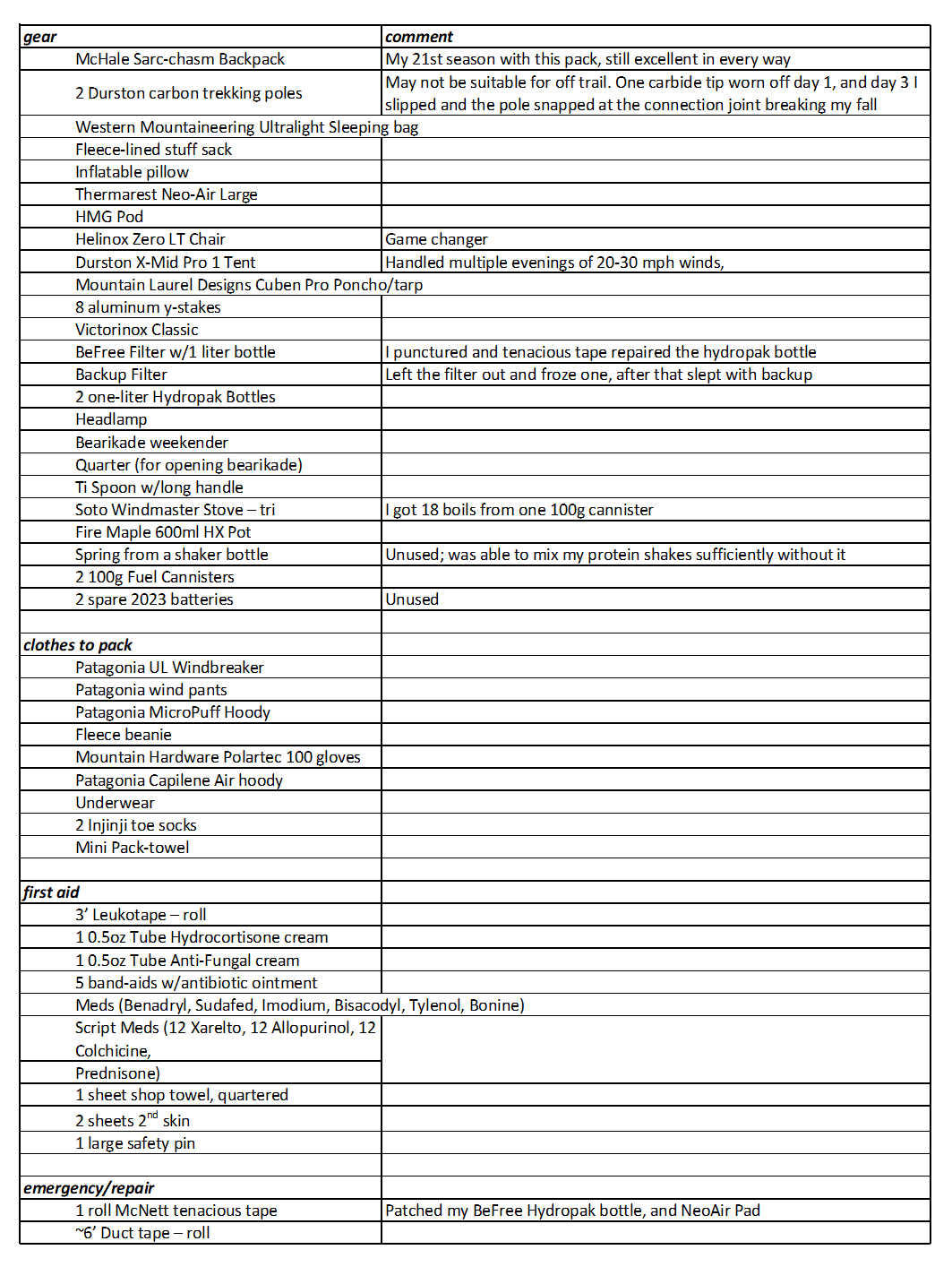
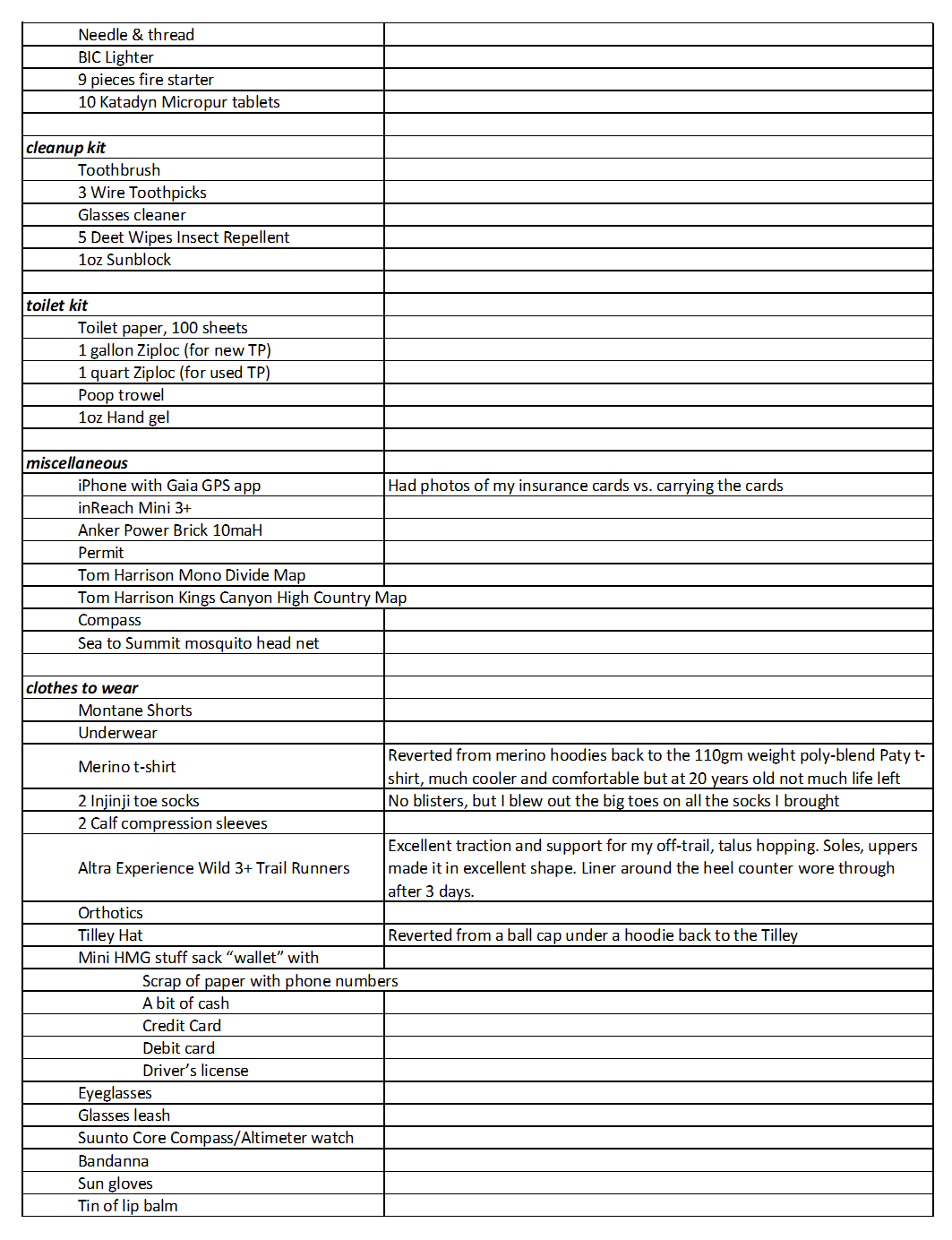
Gear List & some comments
My kit has changed incrementally over the last 15 years. After 57 years of backpacking I know my likes and needs. That said, when I see and meet large numbers of people doing things different, I’ll test it out.
New this year was a Helinox Zero LT chair, a true game changer. I’ve previously used my bear cannister as a stool, and there is simply no comparison. The degree of comfort, ability to relax, and release of tension in my upper back absolutely justify the weight of this luxury item.
On the flip side, I gave up my experiments with sun hoodies and reverted to the wafer-thin t-shirt, Tilley hat, and sunblock. I get a skin rash from synthetic poly blends. Merino solves the rash, but the 150g fabric of the lightest merino hoodies is too damn hot. If I can get my hands on a 110g alpaca hoodie from Arms of Andes, I’ll give the hoodie concept another run.
Menu
I’ve been pounding 1,000-calorie breakfasts for about twenty years. They finally broke me. At 68, these protein and fat bombs now just sit heavy and upset my stomach all day. What to do? I consulted Google Gemini to rethink my approach.
The new strategy: Cut the breakfast calorie load to around 500, shifting from protein- and fat- dominant to complex carbs. For grazing throughout the day, I left the macros at roughly two-thirds fat and one-third carbs, but added an extra feeding to compensate for the breakfast reduction. Starting two hours into the hike, I ate at the rate of one snack per hour. Hydration was one-third to one-half liter of water per hour, including one SaltStick capsule for every liter consumed. Finally, dinner is where I packed in the protein. I selected pre-packaged dehydrated meals with over 40 grams of protein and topped them off with a 50-gram protein shake.
The recommended changes worked flawlessly. I had zero stomach upset, my energy levels remained consistent and high throughout the day, and I had plenty of protein for overnight muscle recovery.