Topic

Solo on the Sierra High Route


Forum Posting

A Membership is required to post in the forums. Login or become a member to post in the member forums!

Home Forums Campfire Trip Planning Solo on the Sierra High Route

Viewing 12 posts - 1 through 12 (of 12 total)
  • Author
    Posts
  • #3375093
    Kyle Meyer
    BPL Member

    @kylemeyer

    Locale: Portland, OR

    Hi friends.

    I’m planning to spend the month of July in the Sierra, most likely doing a variation of the SHR, starting at Road’s End and ending in Yosemite Valley because I have family on the west side of the range. As background, I hiked the JMT a couple years ago and take long off-trail trips for the purposes of backcountry hunting in the PNW. I’m quite familiar with route finding. I bought Skurka’s map book to aid me in planning.

    For those that have done it or are familiar with the area:

    1. When hiking solo, which passes or basins would you skip because of risk?
    2. If you had a bunch of extra time to fish and gallivant, what would do as a side trip or an alternative route?
    3. Anything else you wish you knew?

    Thanks!

    #3375251
    Kiel Senninger
    BPL Member

    @kiel-s

    Locale: San Diego

    I’ve done a couple sections, but none of the passes I did were too bad. I think when researching I read Alpine col can be spicy. Also, this July some of the passes may be holding snow/ice still. Roper’s guidebook is a great resource as is Secor’s High Sierra Peaks, Passes, and Trails. Maybe try posting over on highsierratopix.com too. There’s a lot of folks on there who are super knowledgeable about cross country passes and fishing in the Sierra.

    #3375281
    Ralph Burgess
    BPL Member

    @ralphbge


    [ deleted duplicate ]


    #3375282
    Ralph Burgess
    BPL Member

    @ralphbge

    I did it in 2014.  2016 is looking like it may be at least a “normal” snow year, so July is quite early.  You will need crampons at least;  ice axe and self arrest skills might be prudent.   August or September would be safer, especially solo.

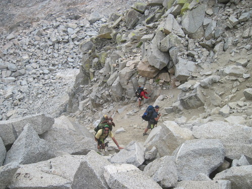
    The occasional spots of actual class 3 (i.e. climbing, both hands on rock) are not particularly daunting or exposed.  The bigger difficulties are negotiating steep loose sections, generally with one pole dug into loose dirt or rubble and one hand looking for holds;  and keeping concentration hopping across extensive talus fields, where a slip down a gap could spell disaster.   Setting aside snow/ice considerations, the north side (descent) of Snow Tongue Pass was by some margin the most dangerous part of the whole Route – very steep, very loose.  This photo gives an accurate feel (from http://www.summitpost.org/mid-snow-tongue/815572):

    In combination with the Skurka maps, you should get the Roper book – you can download the Kindle version to your phone.

    If solo, I’d strongly recommend getting a SPOT device or satellite phone if you don’t already have one.

    Grouse Lake is a gorgeous spot to aim for on your first night if you get an early start.   Later in the trip, my favorite place to linger would be the Bear Lakes & Seven Gables area.   Also Minaret Lake to Thousand Island Lake – that is busier, but you can find solitude wandering away from the main trails up the back of the lakes there.

    Parcher’s Resort (via Bishop Pass) is a good resupply option.
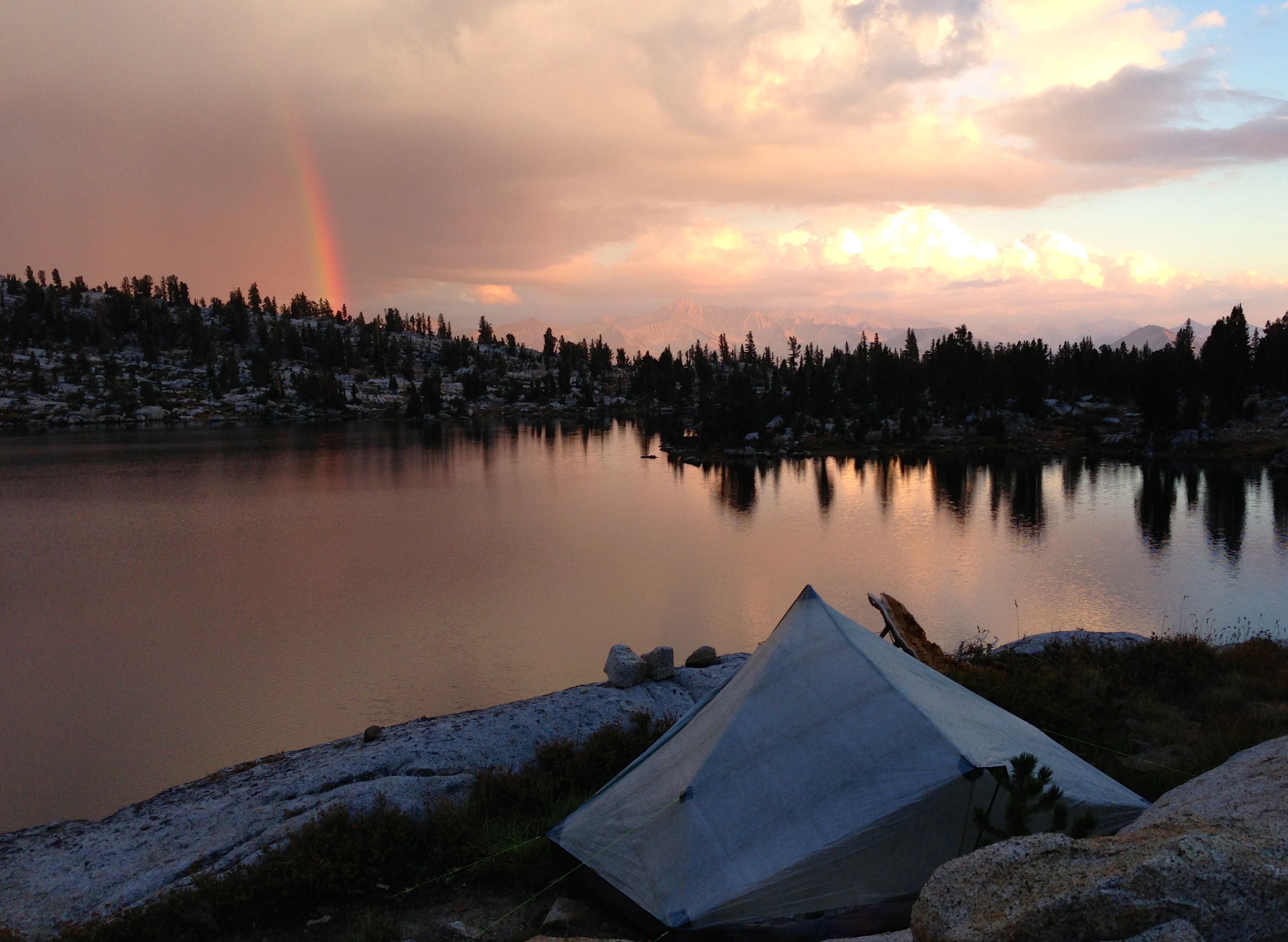
    Grouse Lake

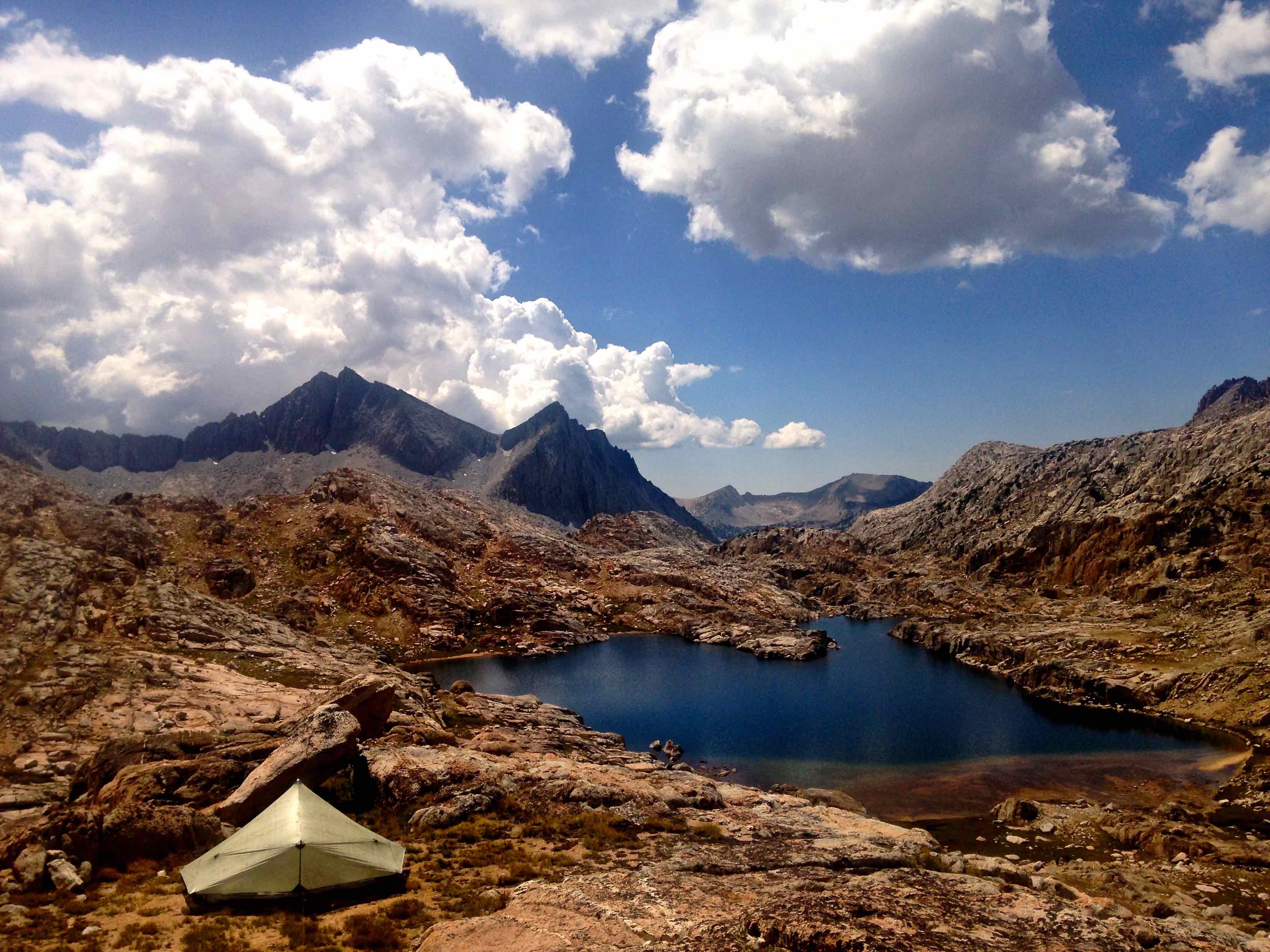
    Big Bear Lake, Seven Gables

    #3375289
    Kenneth Keating
    Spectator

    @kkkeating

    Locale: Sacramento, Calif

    I wonder why one of the individuals is carrying a large teddy bear on top of his pack?

    #3375290
    Kenneth Keating
    Spectator

    @kkkeating

    Locale: Sacramento, Calif

    Ralph:

    What about Frozen Lake pass, how did that compare to Snow Tongue?

    K

    #3375291
    Ralph Burgess
    BPL Member

    @ralphbge

    Frozen Lake is the first major difficulty, the descent (East side) is steep and loose.  And as I recall there’s a whole lot of awkward talus after a steep chute.  Still, easier than Snow Tongue.  But everything was completely snow-free when I was there – it could be a different story with snow & ice in the chute.

    Be sure to look back when you reach the JMT – it looks ridiculous from a distance, you would never imagine that there’s a non-climbing route up there.

    #3376217
    Kyle Meyer
    BPL Member

    @kylemeyer

    Locale: Portland, OR

    Thanks for all the information Ralph!

    Unfortunately, July is the month I have free since August is when I need to start tracking down where the deer, elk, and bear are here in Oregon. :-) Did you cross any snow on your trip at all? I wonder if the passes would be icy enough to actually require crampons, or if an ice axe and microspikes would be sufficient. I have a SPOT already although that’s a really good suggestion (current gear list for the trip). Seven Gables looks amazing.

    Now I’m just hoping for a warm spring. :-) Anyone have experience with some of these gnarlier passes in the snow?

    #3376238
    Ralph Burgess
    BPL Member

    @ralphbge

    I went 3rd week of Aug 2014 – the route was completely free of snow.

    Skurka & Buzz Burrell did it early July 2008.  There’s a video here, you can see them crossing some steep snowfields.

    http://andrewskurka.com/adventures/sierra-high-route/


    There’s no simple answer to what gear you will need.  It depends in part on your schedule – it’s more dangerous early in the morning with frozen crust.   If you’re not in a hurry and you can cross at the best time of day, it can make all the difference.

    If you want to leave something behind, i’d take crampons ahead of ice axe.  Better to have adequate traction and less chance of falling in the first place.

    You might consider replacing a pole with a BD Whippet.  It’s heavy for a pole, but lighter than pole plus ice axe, and you don’t have to worry about when/if to switch – it’s always in your hand.

    #3376379
    Kyle Meyer
    BPL Member

    @kylemeyer

    Locale: Portland, OR

    I’ve decided to set up for a southbound JMT bailout in case the snow is too much—starting at Tuolumne, exiting Yosemite on the SHR over Blue Lake Pass. Got the permit first try to start July 3rd! If it seems too sketchy after that stretch, I can always get on the highway and cruise down to Whitney. : )

    Thanks for your help.

    #3376399
    Ralph Burgess
    BPL Member

    @ralphbge

    Are you aware of the new Donohue Pass quota for Yosemite permits?    That’s now the way they limit JMT traffic.  Without Donohue Pass exit on your permit, you absolutely cannot switch to the JMT to exit Yosemite if the SHR is snowbound.  You risk a heavy fine and unceremonious instructions to leave the backcountry if your permit is checked.   What you can do is to exit Yosemite on trail via Isberg Pass or Fernandez Pass.   The trails south from there through Ansel Adams are sketchy in places, but far easier than the SHR.  You can link up to the JMT near Red’s.

    #3376445
    Kyle Meyer
    BPL Member

    @kylemeyer

    Locale: Portland, OR

    I’m aware of the quota, and Yosemite has changed the permit application forms to emphasize it heavily. I think I’m going to do the SHR to Garnet Lake and then reevaluate, sending an ice axe back home if the route is clear enough to continue reasonably or if I decide to continue on the JMT from there.

Viewing 12 posts - 1 through 12 (of 12 total)
  • You must be logged in to reply to this topic.
Forum Posting

A Membership is required to post in the forums. Login or become a member to post in the member forums!

Get the Newsletter

Get our free Handbook and Receive our weekly newsletter to see what's new at Backpacking Light!

Gear Research & Discovery Tools


Loading...