Topic
snow report at Tuolumne Meadows
Forum Posting
A Membership is required to post in the forums. Login or become a member to post in the member forums!
Home › Forums › General Forums › General Lightweight Backpacking Discussion › snow report at Tuolumne Meadows
- This topic has 14 replies, 11 voices, and was last updated 7 years ago by
 Paul McLaughlin.
-
AuthorPosts
-
Mar 2, 2017 at 7:16 pm #3454044
Here’s the headline: “The snow surveys that we conducted this week revealed historical records for snow depth and water content for March 1. These records date back to 1930.”
this was posted yesterday by the winter rangers in Tuolumnme Meadows.
Mar 2, 2017 at 10:41 pm #3454081Has Colorado got the same sort of record snow depth on the southern part of the divide?
I’m thinking how this might impact on early summer hiking there.
Mar 3, 2017 at 5:32 am #3454102Has Colorado got the same sort of record snow depth on the southern part of the divide?
I don’t know about records but snow pack is solidly above median in each of CO’s river basins.
Don’t jump to conclusions too early though … IIRC it was around median in mid April 2016 but was 200% of median by mid May.
Mar 16, 2017 at 3:31 pm #3457210My guess is that PCT hikers will need to resupply out of Lee Vining, 14 miles east of Tuolumne Meadows, or Yosemite Village, roughly 25 miles to the west of Tuolumne Meadows. Both are served by YARTS -Yosemite Area Rapid Transit System.
Yosemite National Park
March 14 at 6:15pm ·There’s still lots of snow in the high country, so we’ve changed the tentative opening dates for Tuolumne Meadows Campground and Bridalveil Creek group sites from July 15 to August 1. We will not be accepting reservations for dates prior to August 1 for these two campgrounds for now. The campgrounds could still open earlier. We’ll provide updates once we make a determination (we won’t know for a few months, at least).
Campground reservations are available March 15 at 7 am PDT for camping dates from July 15 to August 14 in all other reservation campgrounds (and for August 1-14 for Tuolumne Meadows and Bridalveil Creek group sites) via https://www.recreation.gov/.Mar 16, 2017 at 3:48 pm #3457212“we’ve changed the tentative opening dates for Tuolumne Meadows Campground and Bridalveil Creek group sites from July 15 to August 1. We will not be accepting reservations for dates prior to August 1 for these two campgrounds for now. The campgrounds could still open earlier.”
!!!!! Yikes!!!! A lot of implications for the entire Sierra here.
this part of the pct is gonna be a slog. and the stream–I mean river–crossings!I bet the High Sierra Camps won’t be happening this year…
I remember many years ago when TM opened at the 4th of July and there was snow instantly when I entered the forest at the Sunrise trailhead–all the way through Sunrise Meadows. This year may be worse. So, snow at 8700 feet and up. The bears were hungry that year, my friends. Umm, seriously, now that I think about it, the most aggressive bear by far that I’ve ever encountered was near Sunrise that year. It knocked over a bear pole to get food.
the next spring that I found similar snowy conditions, I did the Grand Canyon of the Tuolumne instead.
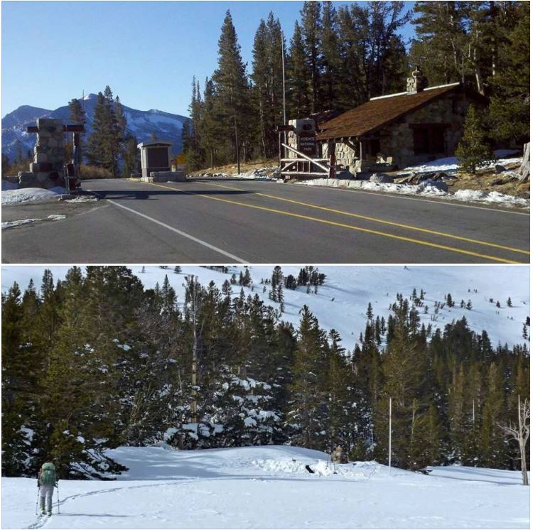
Mar 16, 2017 at 7:24 pm #3457261See the photos below for the Tioga Pass Entrance Station on Tioga Pass Road. The bottom picture was taken recently. Look for the top of the rock chimney in the snowy picture!
 Mar 16, 2017 at 9:57 pm #3457300
Just slightly more snow than I saw in the summer of 2015.
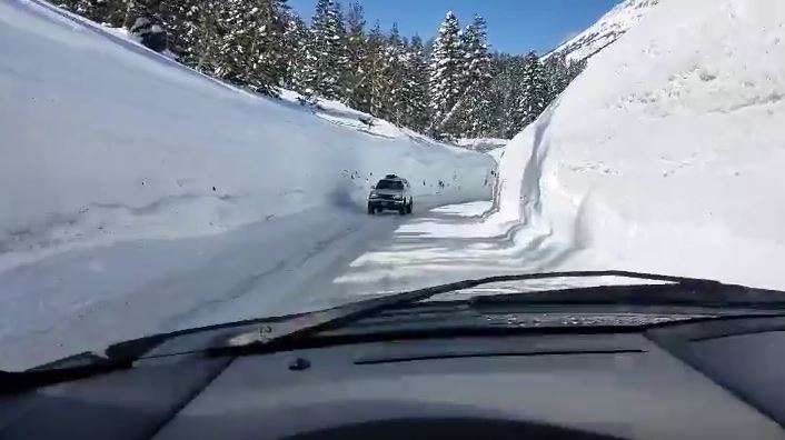
Apr 4, 2017 at 9:38 pm #3461577Close to Tahoe. This has certainty been a winter of epic snow levels.
Apr 4, 2017 at 10:07 pm #3461580How about pct hikers using cross country skis when they hit the sierras this year? Would that be practical?
Apr 4, 2017 at 10:56 pm #3461590I believe the snow will be too consolidated by that time for skis.
Apr 13, 2017 at 1:52 pm #3463069Matt, If the thru hikers are using metal edged skis they should be OK but they will need to carry climbing skins to make any progress carrying backpacks.
Plus they should be somewhat skilled XC skiers. Having an Avy I course would also help. Avalanches happen in spring too. And with this huge snow load on slopes it’s more likely there’s a weak layer or layers on at least some slopes with the right aspect.
Apr 13, 2017 at 3:25 pm #3463085Eric, Can you xc ski over suncups? I wouldn’t think that would work but I don’t know anything about xc skiing.
Apr 13, 2017 at 8:18 pm #3463125Suncups would be the least of your worries. There are dozens of obstacles like downed trees, creeks, snow heaps etc. that make skiing the jmt difficult indeed. To say nothing of narrow trails with trees on both sides, or a cliff on one side, etc. You pick up speed fast on very little slope. With no room to turn, it’s tough and often dangerous. The track will often be rutted and icy. All of this with a pack on our back, plus the weight of ski equipment…I think you need to be highly skilled.
Apr 13, 2017 at 10:11 pm #3463140Oh, metal edges, absolutely! Ah – who would try XC without metal edges???
You pick up speed fast on very little slope. With no room to turn, it’s tough and often dangerous.
Just so! But that is what the sitz-stop is for…Cheers
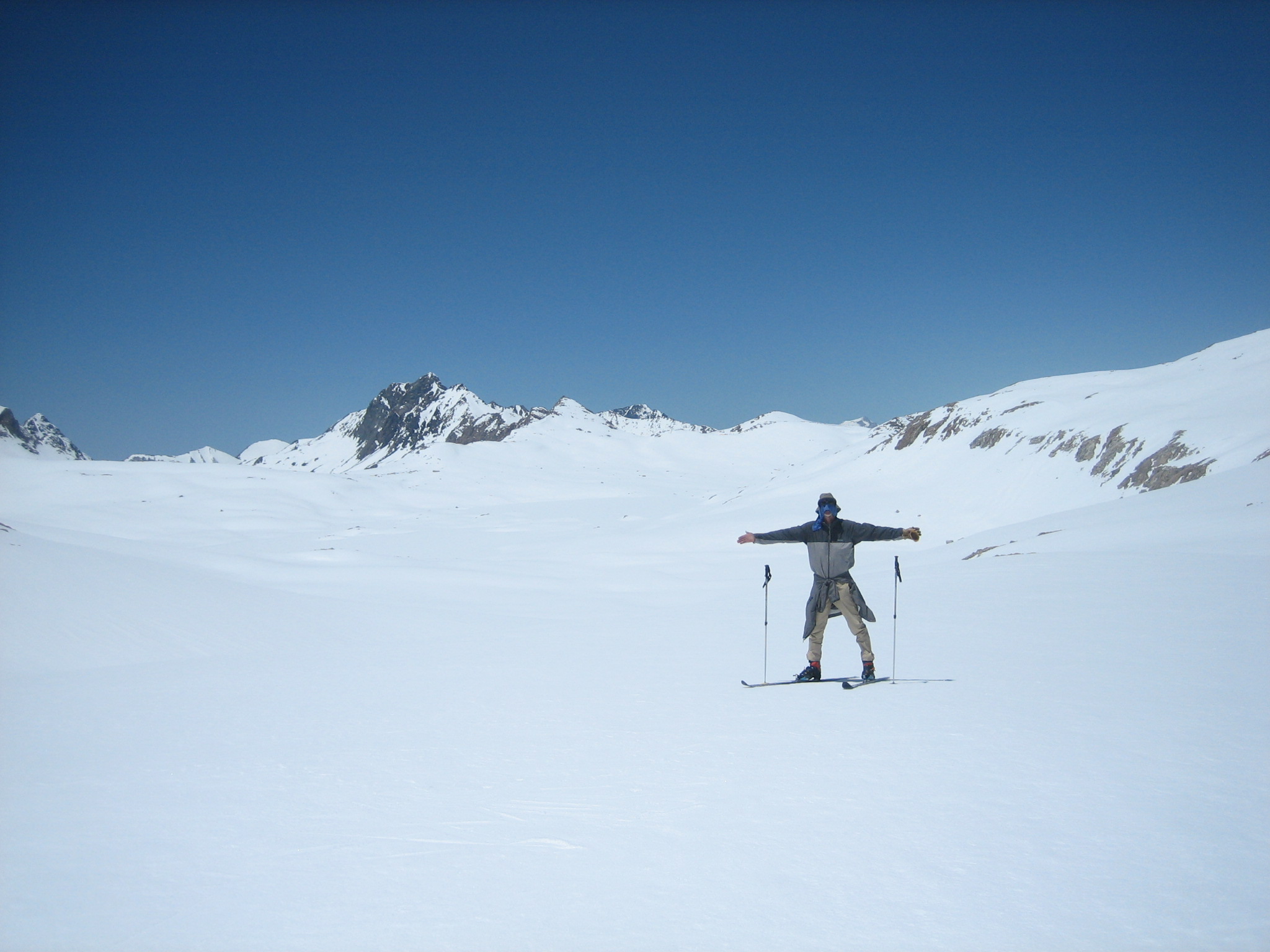
Apr 16, 2017 at 12:03 pm #3463481Suncups won’t be all that bad in late May/early June – they take longer to develop generally. Here is my shot of Wanda Lake from Muir Pass on May 24th 2011 (last big snow year). Nice smooth corn still – skiing was great. A larger issue with a PCT trip at that time of year, would be navigation unless a number of folks have been through ahead of you to establish a route. I rather doubt most thru hikers have the necessary skills to navigate entirely without a trail, which is the way it is up high in that kind of snowpack. Another issue would be having to carry skis, boots and poles down in the valleys when you drop down below the snow – which you would at some points like Bubbs Creek and the canyon of the San Joaquin. Would it be worth carrying skis on those stretches to have the advantage of them up high? I’m not sure. If you start early in the morning while the snow is firm, the walking is quite good for several hours. Uphill you’d go faster without the skis; on the flats about the same. Downhill the skier obviously has an advantage but has to have the skills to handle the terrain, which is not exactly beginner terrain. So the advantages of having skis for some parts of the High Sierra might be outweighed (literally) by the disadvantages on the other portions. I doubt you will hear of many, if any, PCT ‘ers using skis this year. But I expect you’ll see a lot – flip-flopping – folks skipping the High Sierra and then coming back after they reach Canada to hike the part they skipped.
-
AuthorPosts

- You must be logged in to reply to this topic.
Forum Posting
A Membership is required to post in the forums. Login or become a member to post in the member forums!
Our Community Posts are Moderated
Backpacking Light community posts are moderated and here to foster helpful and positive discussions about lightweight backpacking. Please be mindful of our values and boundaries and review our Community Guidelines prior to posting.
Get the Newsletter
Gear Research & Discovery Tools
- Browse our curated Gear Shop
- See the latest Gear Deals and Sales
- Our Recommendations
- Search for Gear on Sale with the Gear Finder
- Used Gear Swap
- Member Gear Reviews and BPL Gear Review Articles
- Browse by Gear Type or Brand.
