Topic

Seeking 6-7 Day Winter Backpacking Recommendations


Forum Posting

A Membership is required to post in the forums. Login or become a member to post in the member forums!

Home Forums General Forums General Lightweight Backpacking Discussion Seeking 6-7 Day Winter Backpacking Recommendations

Viewing 15 posts - 1 through 15 (of 15 total)
  • Author
    Posts
  • #3505998
    David B
    BPL Member

    @dberger1989

    Hi all!

    Longtime lurker here. I’m looking to do a 6-7 day solo hike at the end of December somewhere on the warmer side (don’t want to have to pack a winter-level set of gear) in the US and am looking for recommendations. I’m from the North East and my only experience hiking out west has been in Yosemite. Looking forward to some changes in scenery.

    Some considerations are:

    1. Warm: Hoping to keep it above 40 degrees in the daytime.
    2. Not too technical
    3. The more off the beaten path the better.  Happy pitching my tent in the back-country.

    Some areas I’ve been looking at are Grand Canyon and Canyonlands. Any and all thoughts and recommendations are welcome!

    #3506000
    David B
    BPL Member

    @dberger1989

    Immediately after posting I realize the title wording is pretty poor as I’m actually looking to escape the winter..

    #3506036
    Terry Sparks
    Spectator

    @firebug

    Locale: Santa Barbara County Coast

    I thru-hiked Death Valley two years ago, 6 days and 185 miles of easy and beautiful late January hiking.  Started at the northern boundary of the park, hiked down Last Chance Canyon to near Crankshaft Jct. continued south to Sand Spring, then turned southwest to Death Valley Wash. I then hiked DV Wash south to  Stovepipe Wells, the east side of Cottonbail  Basin and Badwater Basin. After this I hiked south to the Amagosa River, through Ibex Hills and finished at the southern boundary at Harry Wade and Saragoga Spring Road.  Started in ankle deep snow and 5500′, hit 90* in Badwater Basin, with most days roughly 75* and nights in the low 40’s.

    #3506062
    Greg Mihalik
    Spectator

    @greg23

    Locale: Colorado

    Terry –

    Sounds great.  Is there a trip report somewhere? Specifically, What did you do for water?

    TIA

    #3506142
    Terry Sparks
    Spectator

    @firebug

    Locale: Santa Barbara County Coast

    Greg, sorry but no trip report was done for this hike.  For water and food, I cached it all at 4X4 road crossings along my hiking route going south through the valley which was easy to do.  Being I didn’t want to spend a second trip driving the route to pick up my empty cache canisters, I came up with an idea that  worked perfectly.  Originally, I started collecting half gallon milk cartons several months before the hike to use as my water and food cache containers, which would be buried at each cache point. It soon became obvious that I wasn’t going to collect enough of them and found a supplier that could ship them as flat cartons.  What I did was to assemble them into cartons using duct tape to secure the bottoms, put two plastic bags (doubled up for strength) into the carton, fill with water, secure with wire tie and then tape up the top of the carton.    I tested this at home along with burning them and found it worked without problem, as it did for the hike.  The only thing I did differently for the hike was to stack a few rocks over the hole the containers were buried in.  During the hike, I retrieved the containers, transferred the water into my bottles or cook pot as needed, tore up the containers and put them back into the hole to burn them, using a little alcohol if needed to get a complete burn, then covered up the ashes in the hole.  Being I had no worries about starting a wild fire out in the desert, it worked incredibly well.

    #3506162
    Ralph Burgess
    BPL Member

    @ralphbge

    Grand Canyon is an excellent choice this time of year.   There may be some snow and ice near the rim, but it’s unlikely to extend very far down the trails in December.   It will be chilly if you camp above the Redwall, but there is no need to, you can easily get down low enough in a day, so you can camp at the Tonto level or at the Colorado River every night,  where it’s usually pleasantly mild, and maybe even balmy if you get a good week.  And it should be easy to get a permit anywhere in December.   The “corridor” trails (Bright Angel & South Kaibab) are well constructed and well traveled, so even when there’s a lot of snow and ice you need no more than minimal traction devices above the snow line, likely not even that if you have poles and go carefully.   Grandview Trail is almost as good as the corridor trails in the top section where any snow & ice will be.    Other entry trails are steeper and rougher and can be difficult in snow & ice.   So for a 1 week hike, if there is not much snow when you set out, a safe plan is to take a more difficult trail down when you know conditions are easy,  but plan to exit at one of the corridor trails.   This way, if there’s a big snow dump up on the rim during the week when you’re down below, you know you can get out without any problem.

    If you are an experienced hiker but a newbie to the GC,  I could suggest entering at Tanner Trail (initial snow conditions permitting, the upper part is a steep ravine), then turning West to follow the Escalante Route and then the Tonto Trail, exiting via the Bright Angel Trail.   6-7 days is about right this time of year on that route, you don’t want to be doing big daily mileage first time in the GC, and there’s ample scope to explore side canyons if you find you have time.

    The photo below was taken from the Escalante Route in December 2014.   Even when the weather on the Rim is poor, more often than not you can be walking through much better conditions below.

    The only minor difficulty on the Escalante “Route” (95% of it is trail, the rest is well cairned) is some easy 3rd-class ledges at Papago Creek, this photo gives a fair sense of them:

    If you decide on the Grand Canyon, I spend a lot of time there and I’ll be happy to help with trip planning on this or any other route that appeals.   I’m around at home for the next couple of weeks.

    #3506169
    Ralph Burgess
    BPL Member

    @ralphbge

    As for Canyonlands, you may get lucky and find it’s snow-free and sunny.   But the elevation is more like 5000 feet, compared to 3000 feet at the bottom of the GC.    You will have to deal with much colder nights.   And you can get significant amounts of snow, so I don’t think you can safely go out for a week without winter gear.   Water sources in the Needles area are limited, and may freeze.

    #3506555
    David B
    BPL Member

    @dberger1989

    @firebug, thanks the recommendation–that sounds like a good caching system and will definitely keep in mind when I head out that way.


    @ralphbge
    , that hike sounds/looks fantastic and might just be perfect. Right now the path you outlined (Tanner –> Escalante –> Tonto –> Bright Angel) is my working plan. What I’m wondering now is what it would be like getting down the Tanner trail if there were snow on the ground. What do you estimate would be the snowfall required to make the descent down foolish? If this were to happen, do you have any thoughts on a good pivot?

    #3506570
    Greg Mihalik
    Spectator

    @greg23

    Locale: Colorado

    Just a heads up on Tanner – the trailhead is on the right, below road level, ~200 feet Before you get to the parking lot. It’s easy to find if you look for it early.

    The Escalante Route is outstanding. After crossing Cardenas Creek (dry, but with easy river access) look for an obscure trail heading left just as you’re starting the climb. It will take you to a hilltop ruin – just four walls but made of stacked river stone – and then rejoin the main trail. Keep looking back for the alluvial fan at the bottom of Unkar Creek.  With binoculars you will be able to see the ancient walls, gardens, etc.

    I’m jealous.

    #3506572
    Ralph Burgess
    BPL Member

    @ralphbge

    David, depends on experience and abilities of course.    The upper part of Tanner switchbacks steeply down a ravine.  A few inches of snow should be no problem for most experienced hikers – but you will need to take great care if traction is poor, there are many places where a slip would have serious consequences.   Any ice means you need traction devices for sure.   But the forecast is looking good at the moment – the ground is dry now, and the long term forecast shows 0% chance of precipitation through Christmas.   I think there’s enough certainty to go ahead and book your permit – permits aren’t cheap, but changing your itinerary costs nothing, and if you cancel you get credit that’s good for a year.

    If there’s a big dump of snow before you start – well, Grandview and Hermit are a little easier than Tanner, but they would still be challenging for a first trip in a foot or more of snow.   If there’s deep snow on the rim, you will probably want to stick to the corridor trails for both entry and exit, and I’d favor Bright Angel over S Kaibab, it has a steadier grade.   You could then head either east or west on the Tonto, or cross the Colorado and check out Clear Creek.   But it becomes an out-and-back hike wherever you go.

    #3506576
    Ralph Burgess
    BPL Member

    @ralphbge

    Greg, it’s true of course that the Unkar delta is a genuine archeological site, and it’s very cool that there was ever a village there.   But here’s a photo of some of the “ruins” from close up, all the parts that appear to outline the floorplan of substantial buildings look like this:

    So did a hurricane blow through exactly 12 inches off the ground?    And do those rocks look like they were ever part of an actual wall?

    I think at some stage some enterprising members of the boating community realized that the genuine ruins are architecturally important but visually rather disappointing for the casual visitor, and did some creative “reconstruction” to make things more fun for their clients.

    #3506592
    Ralph Burgess
    BPL Member

    @ralphbge

    David, some notes on trip planning:

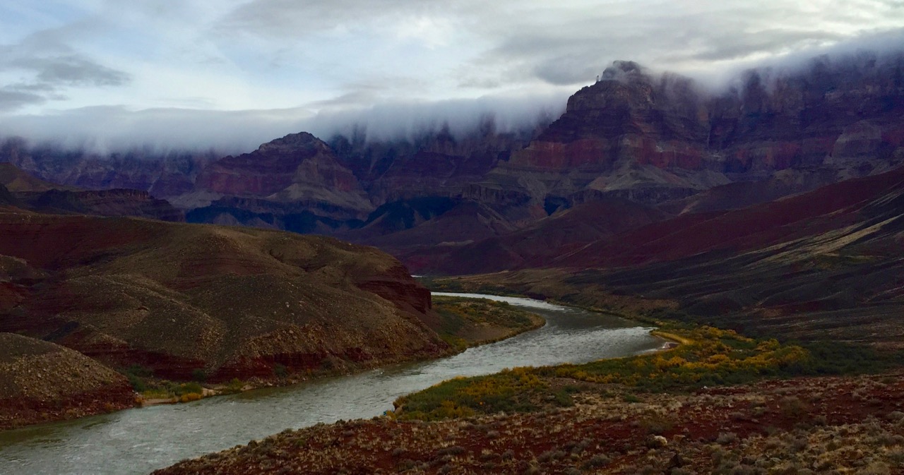
    There’s no water anywhere down Tanner, but if you’re in reasonable shape it’s not too difficult to reach the River in a day.   But you’ll want plenty of time to gawp and take everything in if this is your first trip to the GC, so make a dawn start and don’t forget how early it gets dark.   After the long level traverse in mid-section of the trail, you come to a cairn marking where the trail turns right and cuts steeply down through the Redwall.   Before heading down, continue straight ahead for another 50 yards to the head of the promontory, there’s a spectacular view.  Best Tanner campsites are on the beach immediately W of the wash.

    Easy camping at Cardenas beach, popular spot with boat trips (rare this time of year).  No water between Cardenas and Escalante.   Escalante Beach is small spit of land, but on your own there’s a beautiful spot to camp on golden sand.   The long beach W of the mouth of 75-mile has easy camping, and if it rains there’s a site under an overhang at the back of the beach.   I’ve never camped at Papago beach, but there are spots.

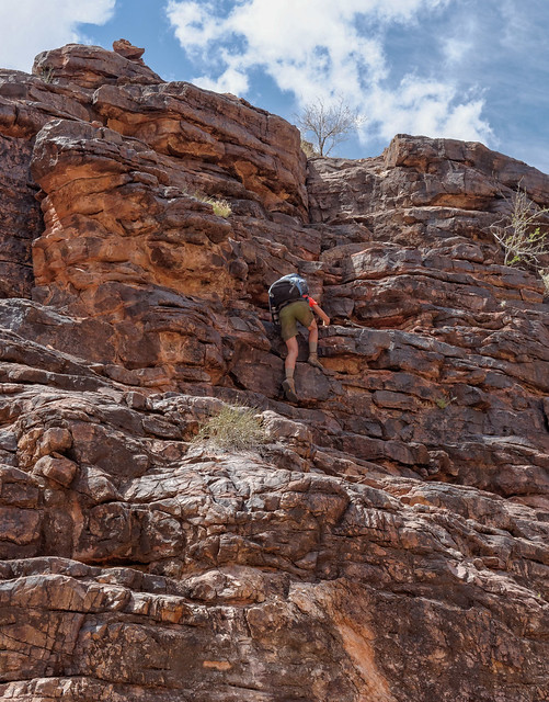
    Papago is where that little climb through the ledges is in the photo I posted, followed by the “Papago slide”, where you have to work your way back down a moderately steep talus slope.

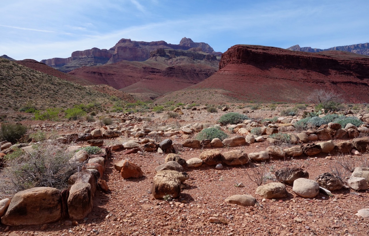
    At Red Canyon (= Hance Rapids) the best campsites (with easy access to the river) are just to the E side of the mouth.   Look across the Colorado here for one of the best examples of an intrusive dike in the world.   Black igneous rock cutting diagonally through the bright red Hakatai sedimentary rock.   It’s one of the images that pops up if you google “intrusive dike”!

    Now you leave the river to climb to the Tonto level, and none of the side canyons west of here grant access to the Colorado for the rest of your hike, so you need to pay more attention to water sources.

    Mineral is dry.   Hance Creek has perennial flow at the trail crossing, many campsites here.  A nice spot, I like camping lower down under the Cottonwoods, although they will have shed their leaves by now.

    From here, you can either continue at the Tonto level out around the head of Horseshoe Mesa, or if you’re feeling energetic make the very steep climb up the Redwall to the top of the Mesa (possibly exploring or camping on the Mesa) before dropping back down the other side to Cottonwood Creek.   There is perennial water at Miner’s Spring (aka Page Spring), well signposted on the trail up to the Mesa, but no water on the top of the Mesa.

    Cottonwood Creek is a pleasant spot with good camping.  There is sometimes water flowing at the Tonto Crossing, otherwise there is a spring further upcanyon that feeds water in from the W side, just above the highest campsites.   I’m not 100% sure if this is perennial, and it has been so bone dry for the past two months that I would try to get up-to-date information on this from the backcountry office.

    There is perennial flow in Grapevine at the trail crossing, and camping here.

    You now have the only long dry section of your hike, where there is no reliable water between Grapevine and Pipe Spring (or Indian Garden).   You may find a spring in Lonetree by walking downcanyon from the trail crossing, but I would not rely on it with the dry weather.   In Cremation there are potholes that fill from rain, but no flow.   So from Grapevine you should carry water assuming a dry camp, not too much of a hardship as you will have eaten most of your food by now.

    South Kaibab trail is completely dry, so with a dry camp the prior night it’s logistically not such a great option, you’d have to carry even more water the prior day or detour west of S Kaibab to Page Spring to refill then backtrack, making for a long tough day to hike out.   Camping your last night at Indian Garden is probably a better option.    Indian Garden permits are usually difficult to get, but this time of year they are often available.  Then a much easier few miles up Bright Angel to hike out.

    #3506947
    David B
    BPL Member

    @dberger1989

    Thanks @Ralph! That info is incredibly helpful as i plan this thing. Seems like i’ll have to be quite careful with how i conserve water after Grapevine. I’ve been trying to get a spot at Indian Garden (or Bright Angel) but it looks like those spots are all full from 12/28-12/31, which is when I would get to that section. I could find an alternate to Indian Garden but hat would your thoughts be on reversing the trail direction and starting from Bright Angel instead?

    #3506982
    Ralph Burgess
    BPL Member

    @ralphbge

    I would not risk an obligatory Tanner exit in winter for a 1 week hike, that’s too long to be able to trust the weather forecast.   Remember you’ll be climbing out into much colder temperatures that you have experienced for most of your hike.  If you get stuck in deep snow at 7,000 feet while trying to exit Tanner without full winter gear and adequate clothing, you’re in serious trouble.   There’s just nowhere else to go.   The corridor trails aren’t a picnic in a blizzard either, but they are comparatively much easier, and in extremis you can wait out a storm out at Indian Garden, with guidance from the ranger station there.

    I would say just take your last night as a dry camp at Cremation, then make a dawn start and hike out from there.   It’s not like you have to carry gallons of water in December temperatures.
    Cremation to S Kaibab trailhead direct = 6.5 miles, but no water.
    Cremation to Bright Angel TH = 11.5 miles, water at Pipe Spring and Indian Garden.
    Either way, you’re starting the exit climb from the Tonto level, already well above the river.   Bright Angel adds 5 miles level hiking, but with plenty of water along the way that would be my choice for a more agreeable day’s hike.   And Bright Angel has a steadier grade if there is snow & ice to get through near the rim.


    #3619448
    David B
    BPL Member

    @dberger1989

    @ralph, came across this post while planning an upcoming Thanksgiving trip and just wanted to say thanks again for the info here! I ended up doing the trail from Tanner and it was one of my all time favorite hikes :)

Viewing 15 posts - 1 through 15 (of 15 total)
  • You must be logged in to reply to this topic.
Forum Posting

A Membership is required to post in the forums. Login or become a member to post in the member forums!

Get the Newsletter

Get our free Handbook and Receive our weekly newsletter to see what's new at Backpacking Light!

Gear Research & Discovery Tools


Loading...