Topic
Sawtooth Wilderness Loop Mid July
Forum Posting
A Membership is required to post in the forums. Login or become a member to post in the member forums!
Home › Forums › Campfire › Trip Planning › Sawtooth Wilderness Loop Mid July
- This topic has 33 replies, 12 voices, and was last updated 7 years, 11 months ago by
 Erick Brown.
-
AuthorPosts
-
Feb 29, 2016 at 8:38 am #3385511
Myself and another BPL’er are doing this 65 mile loop in mid July. Our plan is to tackle it in 5 days.
http://www.trimbleoutdoors.com/ViewTrip/37230
I was wondering if anyone on BPL has done it recently and if they had what information they could share regarding the region, permits, trails, creek/river crossings, weather, mosquitoes, fish reports, etc… pretty much anything you feel that would be useful or of note would be greatly appreciated. Thank you.
Feb 29, 2016 at 11:18 am #3385548Last July a group of us did a smaller loop (two campsites) just S of the one you are planning, camping up to 8900′. One night the temps were in the mid 20’s with light snow, but the day before we were hiking in T shirts. Didn’t see many mosquitos for the most part, but there were some in wetter areas along the trail.
The permits were easy to get. However, finding a campsite before/after your trip can be a trick unless reserved ahead of time, or unless you start looking by mid-day. FYI, there is legal road-side free camping along either Stanley Creek or Flat Creek roads (I forget which) if you can’t find a paid campsite – just West of Stanley, ID. If your dates are fixed, then consider reserving a campsite in the Stanley area in advance for before and after the trip to avoid driving around for hours looking for a open site.
Feb 29, 2016 at 11:20 am #3385549Thanks for the reply. We are starting from the Grandjean side not the Stanley side so I do not think this will be an issue. I appreciate the input.
Mar 30, 2016 at 11:46 am #3392786Still looking for any and all useful information on the Sawtooth wilderness.
Mar 30, 2016 at 9:40 pm #3392919I did a major portion of your trip – from Sawtooth Lake to Spangle/Ingeborg Lakes – a couple summers ago and also in mid-July. Its a great trip. Permits are a non-issue. You sign-in at the trailhead and go. River crossing – are also a non-issue. Your feet will get wet in a couple locations but I experienced nothing more. The only place where mosquitoes were an issue was at Ardeth Lake. Trails were in fair condition and wildly overgrown in only one section – along North Fork of Baron Creek. Campsites are scares along Baron Creek. Vegetation is also overgrown in this section so you have limited access to the stream until you approach the waterfall. I highly recommend some of the side trips that you’ve planned. I haven’t done the return from the Ingeborg Lake area to Grandjean but I’ve heard it is long and not particularly exciting. For our trip, we turned south at Spangle Lake and headed into the Flytrip Basin, cross country to the headwaters of Alpine Creek and exited via the Alturas Lake TH. I guess i should also mentioned that water access is excellent so you will not need to carry much water. Weather should also be excellent. July is the warmest month in the area (but only by a couple of degrees when compared to August).
Feel free to ask any questions. I live in the Sun Valley area and have done a number of trips throughout the area and have more planned for this summer – including a hundred miler along the middle fork of the Salmon River in early July.
Mar 31, 2016 at 9:14 am #3393003Kevin
I don’t know what happened on the Trimble site but here is the GPX file of the loop and the KMZ file for Google earth. We are planning on doing a side trip to Observation Peak, Mount Regan and Mount Cramer and possibly the feather lakes. One of my biggest concerns is snow in the passes. I have heard from a few people that micro spikes and gaiters were definitely necessary as there was still a lot of snow. I look forward to more info!
https://www.dropbox.com/s/0wsbwniy3z68dwp/Sawtooth%20Range%20Loop%20-%2065%20miles.gpx?dl=0
https://www.dropbox.com/s/cg1umdna9f3kl0x/Sawtooth%20Range%20Loop%20-%2065%20miles.kmz?dl=0
If that doesn’t work I have imported it in to Google Maps
https://www.google.com/maps/d/edit?mid=zUHDJw3rHTtg.k1AE5ZcOnd6s&usp=sharing
Mar 31, 2016 at 9:51 am #3393015We had lots of snow this year in the region but warm weather came earlier than normal so I would not expect any issues in mid July. Feel free to check in late June and I’ll give you an update.
As for view your Trimble file, i had to login to trimble to view it. Once I did, I was able to see the route and give you the feedback noted above. Lots of great camping and fishing sites along your route. The only place i would not recommend is along Baron Creek. Lots of vegetation that limits your view. Baron Lake is spectacular at dusk and dawn.
Mar 31, 2016 at 9:56 am #3393018Kevin,
Here is our tentative itinerary.
Day one we start at 5300 ft at the Grandjean campground, take a side trip to Observation peak (9,100ft) then end up at Sawtooth lake (8400ft) after hiking 8.29 mi then on the second day we would do Mount Regan then hike down to 5400 ft then back up to 8400 ft and camp at Alpine lake (Mile 19.5 of the hike so we do roughly 13 miles on day two, the next day we do 15.2 miles (crossing our highest point just above Cramer lake at Cramer Divide do Cramer Peak and then camp at Lake Ingenberg total miles now at 35.2. The following day we do another 15 miles stopping at the river (trip mile 50) and the last day we hike 10 ish miles. This mileage is if we stick to the trail. These side trips take the mileage up to the 65 mile range.
Mar 31, 2016 at 2:31 pm #3393084This is a great itinerary. Especially like the side trips up Regan, Cramer, etc.Too bad you guys dont have time to do the Elephant Perch. Sawtooth, Baron and Cramer lakes are where you’ll see the most people as they are easily accessible from the Stanley/Redfish lake area. Sawtooth lake, in particular, gets a lot of day traffic from day hikers and trail runners. You might be able to escape the crowds by picking a site on the South side of Sawtooth Lake.
Day 3 is the only area where I see you might be over-estimating your mileage expectations. My son and I did a similar distance, Baron lake to Spangle lake, and it was a long day. Lots of up and down. We didn’t attempt Mt. Cramer so that will be additional time, distance and effort for you. There are lots of lakes along the way, however, if you decide to stop before Ingeborg. Lots of people speak highly of Ardeth lake although i thought others spots were more scenic (and had a lot less mosquitoes).
I should add that in my opinion the trail from Baron lake to Benedict lake is the most spectacular so dont rush it. Day 2’s itinerary is less interesting although Baron lake is spectacular…as is the Alpine lake area. You will see more people in this area as well although not as many as near Sawtooth lake. Once you get beyond Cramer lakes you’ll see much less people on the trail.
Mar 31, 2016 at 2:54 pm #3393087Kevin,
I figure if we do less miles on day 2 or 3 we can make them up on days 4 and 5 as they are all down hill. Thankfully as you said there are lakes the entire route and plenty of places to camp. Mt Cramer and the feather lakes are each about 1 mile off trail (one way). Mt Cramer seemed the easiest as we just follow the ridgeline to the peak (the elevation plot doesn’t look too daunting as its 1,000 ft in 1 mile) and the featherlakes looked tough as we would have to start at a lake go over a ridge down to a lake then back up and out to the trail and on for the rest of the day. So that one is probably not going to happen. I heard the fishing was better at those lakes though. We are hoping to see as few people as possible.
Mar 31, 2016 at 3:54 pm #3393097I have not done the Grandjean to Sawtooth trail so I can’t speak to how many people you’ll see. We saw a lot from the Stanley to Sawtooth side. After Sawtooth lake, we saw no one until we reached Baron lake(s). You will see folks up to Cramer due to its proximity to Redfish but after that…i expect you to see few if any.
With regard to Mt.Cramer, yes, it only a mile from the divide but beware. It’s steep and deep and no trail. Lots of boulder hopping and scree sliding. I have not done it but it will take more time than you think. The way to think about the Sawtooths is lots of narrow ridges with lots of scree and boulders. I can’t imagine that you’ll need gaiters and micro spikes in mid July but your routes goes up and down more than you’ll expect.
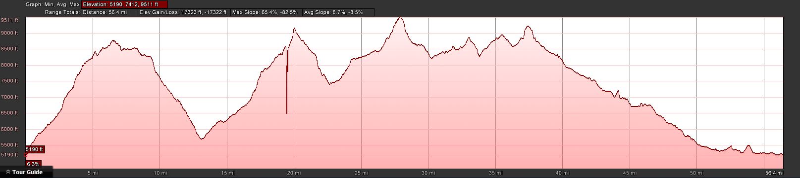
Apr 1, 2016 at 6:29 am #3393214Yeah I have plotted the elevation changes for the entire trip and Day 1-3 look pretty rough. But I am training for that by doing roughly 20 miles a week of on trail training with some good elevation changes with a fully loaded pack. I did an off trail trip in the La Sal Mountains in Eastern Utah last year that was all scree fields it took a lot longer than anticipated. We will have to gauge these side trips once we are on trail though. I have combed through hundreds and hundreds of photos of the trails and the lakes and I have a pretty strong idea of the terrain and what it looks like. I live in Arizona and most trails here are rocky and rough so as long as I continue to put in the miles every week I think I will be prepared. Once it warms up in the high country here I plan on spending at least one weekend a month hiking above 10k ft and on some tough trails to acclimate to altitude. This is the elevation plot of our entire route (minus side trips).
 Apr 1, 2016 at 7:33 pm #3393381
If you haven’t been to the Sawtooth’s before I highly recommend that you see the Sawtooth Valley and Redfish Lake. Beautiful place and will give you the best perspective on what you are about to hike thru.
Apr 1, 2016 at 10:34 pm #3393430Heath, this looks like a great all trail loop option that gets you in and gives you a flavor of the area. However, if you have flexibility, the off trail options in the Sawtooths are many and it gets you away from people and in to some big fish.
i did a north to south traverse starting at iron Creek TH and exiting Pettit Lake. It was about 50/50 on vs off trail and we went 4 straight days without seeing another person. Spectacular trip. In fact, we are going back for more in August.
i can’t help you on snow because we went in mid August when it was a total non issue. Weather was great with a few afternoon thunderstorms. Basic Rockies behavior. Bugs were zero!
Apr 4, 2016 at 7:21 am #3393824Kris, Kevin,
As the trip is planned I do not have any extra time for other trips/ visits on this particular trip. When I spoke with the Ranger station in Stanley they said we might see 4-5 people once we leave the Sawtooth lake area.
Jun 26, 2016 at 4:30 pm #3410905We are doing almost the exact same route but in the opposite direction (counter clockwise), departing July 8. Might head down the N. Fork Boise River Trail to start but can’t find any info about it so will probably just head up Payette.
Jun 27, 2016 at 11:01 am #3411026Did your exact route 2 years ago over 4 days in early September. It was very hot and dry by then, so I am not familiar with the July levels of snow on the passes.
Your miles are fine, I wasn’t in the best condition when I did this and it was all very easy – but, I did not have any snowy passes to contend with either.
The trail up to Observation Peak is badly scarred from a burn, so you will have to do some route finding. I initially mentioned to skip that trip, but the pictures I saw online look much better than my memory from there. Most of my pictures have lots of burned trees in the frame, so that may be why I didn’t enjoy it as much. The pictures on SummitPost, for instance, are most certainly prior to whatever fire went through there.
Permit is just a self-registration box, so no issues there.
I did see some people fishing along the trip – I think I recall them being on one of the south-most lakes.
The creeks draining into the SF Payette River the last few miles south of Grandjean looked like they could be very difficult to cross during snowmelt. I think I recalled crossing either 2-3 creek beds along that stretch that are very wide and decently deep. I did not see any footbridges there. I would definitely ask the ranger about those before you leave. From my memory, those should be the only crossings of any concern.
Jun 27, 2016 at 3:12 pm #3411057Collin,
We actually decided to go in reverse from what was originally planned so that we could acclimate to the altitude. We are starting July 9th. I spoke with the Ranger station this morning and they said snow level is currently 8,200ft and that we should expect a lot of snow on trails above this, especially in the passes. They said 1-3ft of snow in places. Will definitely be cautious in creek crossings. Thank you.
Jun 27, 2016 at 5:27 pm #3411082Heath, thanks for the beta! Sounds like we might cross paths out there, I’l be in a group of 3 of us and I have a red ULA pack. Snow is generally really packed in this time of year so is a bit slippery in the mornings but good by mid day. Just did an overnight above me in the Cascades with snow the entire way, I guess that was good practice! Makes me think this might be a trip for 2 pairs of socks though…
Jun 28, 2016 at 8:50 am #3411164We will be in a group of 3 as well. I’ll be carrying a HMG Southwest 3400 in White. No problem. I always try and get as much info as I can on an area before heading there and am always happy to share that with others. Do you have any side trips planned to any of the peaks in the range or any fishing planned?
Jun 28, 2016 at 1:56 pm #3411219One of the guys is a very good fisherman so he’ll be doing plenty of that. I’m a photographer by trade so will spend my evenings and mornings looking for good shots. We are pretty fast movers so hope to cover ground and have enough time to scramble up a couple peaks too. Not sure which at this point, kind of taking it as it comes due to the snow levels.
Jun 29, 2016 at 1:37 pm #3411407Thanks for this discussion. Hope you guys have great trips. You’ve given me ideas in an area of the country I haven’t seen yet…
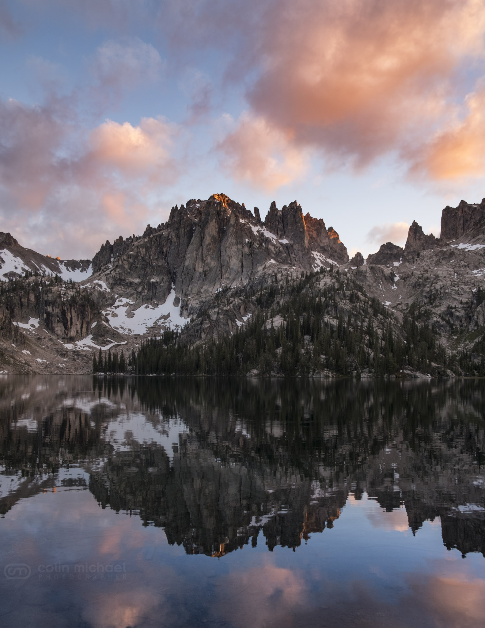
Jul 14, 2016 at 11:22 am #3414220What a trip! Heath, did you guys get nailed by the snow? We were coming over Cramer Divide when it started and were ankle deep by Cramer lakes! Weather didn’t cooperate for great photography until the last night but oh boy did it ever come through! Great time, I’d go back in a second.
Jul 16, 2016 at 1:03 am #3414538Amazing photo Colin. Thanks for sharing.
Jul 16, 2016 at 3:14 pm #3414607Hi Colin,
I hiked with Doug and Heath on this hike. We were hit with the first snow storm on July 10th as we ascended up to Lake Benedict and visibility dropped to 200-300 feet. Not a big deal but our original forecast only showed precipitation for the 10th and then we received an updated forecast via Delorme that showed a storm system moving in on the days that we would be 1000 or so feet higher than Lake Benedict and crossing the mountain passes. From speaking with the Ranger station the day before, they didn’t have good information on the conditions of the passes and we didn’t know how tricky or easy they would be during a snow storm. We agreed that although we were armed with microspikes and ice axes, the possibility of cutting steps in a whiteout didn’t sound all that appealing.
We erred on the side of caution and returned to the trailhead, headed north, and then hiked the Seven Devils loop instead. While not as high, there are sections of the trail that get up to 8000′ and the Seven Devils trail received upwards of four inches of snow from the second storm.
As we were driving to Riggins, we saw 20-30 lightning strikes in the Seven Devils region and the rain at times reminded me of the monsoons I have experienced in Panama, so we indulged in a night in a hotel to dry out our gear, ride out the storm, and destroy the most decadent of burgers. Most of the snow melted off the trail by the time we hiked it but there were patches hanging on.
Per the rangers, temps had dropped to 16*F during the storm which would have pushed what we were geared up for to it’s max comfortable limit, if not a bit beyond. The Seven Devils doesn’t receive the same level of maintenance as the Sawtooths so there were more than 100 blow downs to contend with and sections that were so overgrown that it was tough to discern the trail in sections, and others where we were bushwhacking on what should have been the trail. In hindsight, enjoying a warm night hotel instead of braving the second snowstorm in the Seven Devils was the best choice. By no means was this a life vs death choice but I think we dodged some type three fun.
I’m bummed that the Grand Sawtooth Loop didn’t work out this year but I had a great time with two great friends. The Seven Devils Loop is just such a beautiful and rugged trail so I didn’t feel like we were shortchanged. This was my third time hiking it and each experience has been unique. Seeing my first mountain lion in the wild didn’t suck either.
-
AuthorPosts
- You must be logged in to reply to this topic.
Forum Posting
A Membership is required to post in the forums. Login or become a member to post in the member forums!
LAST CALL (Sale Ends Feb 24) - Hyperlite Mountain Gear's Biggest Sale of the Year.
All DCF shelters, packs, premium quilts, and accessories are on sale.
Our Community Posts are Moderated
Backpacking Light community posts are moderated and here to foster helpful and positive discussions about lightweight backpacking. Please be mindful of our values and boundaries and review our Community Guidelines prior to posting.
Get the Newsletter
Gear Research & Discovery Tools
- Browse our curated Gear Shop
- See the latest Gear Deals and Sales
- Our Recommendations
- Search for Gear on Sale with the Gear Finder
- Used Gear Swap
- Member Gear Reviews and BPL Gear Review Articles
- Browse by Gear Type or Brand.
