Topic
Real-time Fire and Air Quality by text, inReach, etc.
Forum Posting
A Membership is required to post in the forums. Login or become a member to post in the member forums!
Home › Forums › Campfire › On the Web › Real-time Fire and Air Quality by text, inReach, etc.
- This topic has 3 replies, 3 voices, and was last updated 2 years, 1 month ago by Arthur.
-
AuthorPosts
-
Feb 23, 2022 at 11:36 pm #3741377
Just found trailinfo.org
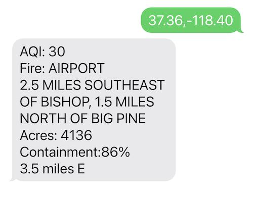
Text your U.S. latitude and longitude to (765) 55-FIRES (+1-765-553-4737), and get the nearest Air Quality Index reading, plus wildfires within 50 miles. In the example above, I used an iPhone to text the lat/lon for Bishop, CA and show the still-active Airport Fire nearby. Designed to work from an inReach and other satellite communicators.
Send your current location (easy from inReach), get local information. Worried about a far trailhead, pass, or other location? Take those lat/lon coordinates with you and check from time-to-time during your trip.
Should be very useful during our new era of wildland fires and smoke.
— Rex
Feb 24, 2022 at 9:40 am #3741404from faqs…
“This doesn’t seem to work with the inReach “Send Reference Point” feature.
Yes, I discovered this issue when testing the app. The “Send Reference Point” function of the inReach does not currently let the recipient successfully reply back to the sender. You can test this by sending a message to your own phone and trying to reply. I opened a support ticket with Garmin on this, but more tickets might get a faster resolution, so feel free to do the same.”
Feb 24, 2022 at 2:32 pm #3741457Sending a Preset or Text message from an inReach device usually includes your current position, and should work fine with TrailInfo.org.
From the inReach SE and Explorer manuals:
Sending a Reference Point
You can send a message that includes a reference point with details about another location. This feature is helpful if you want to meet someone at that location.Sending a Reference Point not found in the Mini / Mini 2 manuals.
If you want to know about another location, you’ll need the latitude and longitude in decimal degrees. Two decimal places, roughly 1 mile (1.6 km) maximum inaccuracy, should be close enough for these purposes.
You can click locations and get lat/lon with too many decimal places from google.com/maps, which is what I did for Bishop. Or figure it out the old fashioned way from genuine USGS paper topo maps. There’s probably a bunch of other ways.
— Rex
Feb 24, 2022 at 2:34 pm #3741459edit: already answered
-
AuthorPosts
- You must be logged in to reply to this topic.
Forum Posting
A Membership is required to post in the forums. Login or become a member to post in the member forums!
Our Community Posts are Moderated
Backpacking Light community posts are moderated and here to foster helpful and positive discussions about lightweight backpacking. Please be mindful of our values and boundaries and review our Community Guidelines prior to posting.
Get the Newsletter
Gear Research & Discovery Tools
- Browse our curated Gear Shop
- See the latest Gear Deals and Sales
- Our Recommendations
- Search for Gear on Sale with the Gear Finder
- Used Gear Swap
- Member Gear Reviews and BPL Gear Review Articles
- Browse by Gear Type or Brand.