It’s a mystery.
Topic
OK Where is the unusually deep snow in the Wind River Range
Become a member to post in the forums.
- This topic has 1 reply, 1 voice, and was last updated 6 years, 11 months ago by
 .
.
Viewing 2 posts - 1 through 2 (of 2 total)
I’ve been cruising a combination of Postholer, snotel and The Noaa snow depth site to try and figure out what the snow is like in the Winds. As you may have noted I’ve posted a bit of this info , links etc. and also had a few PM’s with friends and there had seemed to be a little discrepancy about mile point locations on the Postholer site so I took a careful look today.
So now I’m really confused. The Postholer Continental Divide Trail Snow Table, Highest to Lowest Mile Point Order has the location of Hat Pass; which is about as good a point as any to divide the Winds in half north/south, as mile 1819.8.
On their list of mile points labelled Waypoint Detail Hat Pass is specified as @ Mile Post 1861.5.
Depending on which one is correct the unusually deep snow is either totally north of Hat Pass or completely south of Hat pass. One way or the other!
It seems like the moisture feed and deep snowfall this winter /spring has been from south to north and I would guess that the mileage points for their waypoint detail section has been around longer than their new snow profiler tables but something is definitely out of sync.
If you click on the far left hand column “Trail Mile” to sort the locations sequentially Hat Pass listed as MP 1819.8
 Hat Pass on Waypoints Data Table
If you go to this next Mile Point data table and to the page for Wyoming Section 10 you’ll see Hat Pass listed as Mile Point 1861. This is evidently the older and most likely better verified table
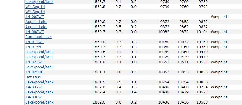
I verified that both points are attached to the same place, the same Hat Pass. Maybe in getting this new and useful tool online the mileages got out of sync? So the deep snow is South from @ the East Fork down past Wind River Peak or North From @ The Mt Baldy Basin, Spider Lake and Angel Pass up to near Knapsack Col. Take your pick! It’s a mystery. The snotel sites and the noaa map would maybe verify Hat Pass as being @ MP 1861 based on what one might glean from their data but it’s not definitive. Anyway there’s a stretch of about 40-50 miles along the CDT in the Wind River Range that has unusually deep snow this year. Which stretch?
BTW I’m not trying to pull a gotcha on Postholer. I think their site is really great!. If you visit the site click on a couple of ads. They’re not operating on air.
Viewing 2 posts - 1 through 2 (of 2 total)
Become a member to post in the forums.

