Topic

Ohlone Wilderness Trail, central California


Forum Posting

A Membership is required to post in the forums. Login or become a member to post in the member forums!

Home Forums Campfire Member Trip Reports Ohlone Wilderness Trail, central California

Viewing 9 posts - 1 through 9 (of 9 total)
  • Author
    Posts
  • #3396442
    Rex Sanders
    BPL Member

    @rex

    Plan: ~80 mile, 5 day yo-yo (with extensions) on the Ohlone Wilderness Trail, in central California roughly between Livermore and Fremont.

    Actual: I totally screwed up the planning, put the longest and hardest days at the front of the trip, and trashed myself. Also, the virtually nonstop drone of airliners on approach to SFO from 6 am through 1 am was not fun. Shortened the trip to ~44 miles and called for pickup one day early. Unless the flight paths change, not sure I’ll go back.

    Background: Ohlone Wilderness Trail runs from Del Valle Regional Park near Livermore, through several “wilderness” areas and other regional parks to end in Fremont at the western foot of Mission Peak. Regulations require camping in assigned camp sites, which typically have outhouses and running water which must be treated. Official trail length is about 28 miles; with connecting trails and alternate trailheads you can configure longer (much longer) and shorter trips.

    Day 1, April 10, 2016 – 15.5 miles, ~5000 feet total elevation gain
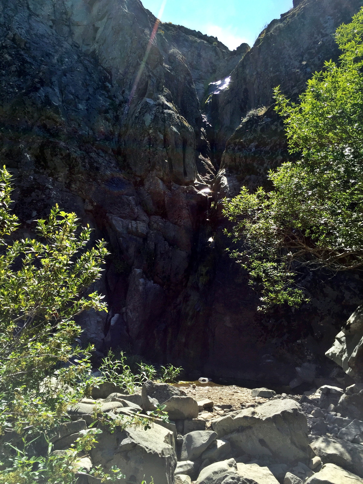
    At 10 am, my wife dropped me off at the Del Valle Arroyo staging area, below the dam for Del Valle reservoir, and about 10 miles from one end of the Ohlone Wilderness Trail. Started the hike roller coastering along the shores of Del Valle Reservoir. Fortunately for California’s drought, but unfortunately for me, rain had been falling lightly for several days. This turned several sections of the trail into nearly impassable mud bogs. One 100-yard section took 25 minutes of falling, sliding, and much cursing to traverse, more like skiing down mud slopes than hiking. Surprised to run into several dozen other backpackers on the trails that day, all complaining about the mud. Light rain fell off and on through the day, old Golite Chrome Dome umbrella was very handy. In the fog and twilight I missed the turnoff for Murietta Falls, one of the major highlights of the trip. Just as well, arrived at Stewarts Camp just before dark at 7:20 pm, exhausted and borderline hypothermic. So tired I barely noticed the airline traffic that didn’t stop until 1 am.

    Day 2 – 18 miles, ~3000 feet total elevation gain
    On the trail about 8 am, but steep downhill section through the Sunol Backpack Camp area (what lunatic laid out that campground?) triggered serious foot and leg pain. Took Aleve and pushed through to Eagles Nest campsite near the top of Mission Peak, arriving about 6:30 pm. Somewhat less airline traffic directly over Mission Peak. Clear for much of the day, thick fog descended at sunset, visibility less than 20 yards.

    Day 3 – 8 miles, ~1500 feet total elevation gain
    Planned on ~18 miles this day by hiking on alternate trails, decided to beeline to next assigned camp instead. I moved very slow due to serious foot and leg pain. With multiple doses of Aleve, and lots of rest stops, dragged myself into Eagle’s Eyrie camp early in the afternoon. Water spigot 50 foot elevation drop on steep, muddy trail; outhouse 110 foot elevation drop on steep muddy trail; brilliant campground design! In addition to the steady drone of airline traffic, add propane cannons blasting every few minutes to keep birds away from the Calaveras Dam reconstruction site a couple miles away. Ah, wilderness! Slept from 1 am to 6 am.

    Day 4 – 4 miles, ~1200 feet elevation drop
    Dragged myself back to Ohlone Regional Wilderness park headquarters, where my wife picked me up and we returned to the peace and quiet of our home in the woods.

    Good news – some quite lovely patches of wildflowers; very nice views when the fog lifted; several of the small tweaks to my gear worked out great.

    • Added bungie cord loops to the tieouts on my Tarptent Moment-not-DW, which eliminated overnight sagging of the silnylon.
    • First trip where an umbrella proved useful for blocking wind and rain, and adding surprising warmth in the process. Easy to tuck into base of shoulder strap between showers.
    • First trip with Tyvek sit pad (14 grams) from cut-down large envelope, worked great to keep my butt clean and dry during rest stops.
    • Discovered DeLorme inReach SE “Extended Tracking” feature, which made a huge improvement in battery usage. Roughly 10% per day at 10 minute tracking, while still receiving messages.
    • First trip with Nemo Astro Insulated Lite sleeping pad – quite comfy for side sleeping; sometimes warmer than my 30°F sleeping bag!
    • First trip with using empty Crystal Light boxes to keep sunglasses from getting crushed in backpack. Relatively light at 30 grams each.

    My next trip will be much farther from any major airports. And I’ll start easier.

    — Rex

    #3396473
    d k
    BPL Member

    @dkramalc

    Nice!  That is indeed a tough first couple of days – we did it years ago from Del Valle to the camp nearest Rose Peak (Maggie’s Half Acre?), then to Mission Peak entrance the next day, but never from further back where you started.  I’ve always considered that the toughest hike in the Bay Area.  Congratulations on doing it despite the foot and leg pain.  I don’t remember jet noise, but that was a while back so maybe they’ve changed their flight plans since then.

    #3396501
    Rex Sanders
    BPL Member

    @rex

    d k,

    Thanks for the comment. Yes, the camp just below Rose Peak is Maggie’s Half Acre.

    I think a large part of my foot and leg pain came from struggling through the mud bogs on the first day. Four days after getting off the trail, my left foot still hurts sometimes, possibly a very mild strain or sprain from a fall that pulled off the shoe.

    In March 2015, the FAA changed flight patterns significantly nationwide. In the San Francisco Bay Area, new areas of highly concentrated traffic have thousands of people up in arms. Guided by precision GPS, it’s like watching the planes fly overhead on rails, with the noise from the next plane building as the previous one fades away. The new paths are much worse for the people (and animals) on the ground than the old paths.

    Might be good to check current flight patterns before backpacking near major airports. Tents and tarps and earplugs don’t really block aircraft noise.

    — Rex

    #3396559
    d k
    BPL Member

    @dkramalc

    Yeah, East Bay trails can get very muddy and sticky in the rain, with our clay soil.  That one is one of the worst…have had several pounds of mud on my feet, stopping periodically to scrape off what I could.


    I knew the flight patterns had changed around home, didn’t realize it carried out so far, or that it had such an impact on sound levels when backpacking!  Too bad; that makes it much less likely I’ll want to do an overnighter on that trail again.

    #3400597
    Adam White
    BPL Member

    @awhite4777

    Locale: On the switchbacks

    Well, sounds memorable! Thanks for sharing.

    The Ohlone trail (and the rest of the EB “wilderness”) has a special place in my heart. It certainly has its charms. Speaking of charms, you didn’t mention the cattle, or the gifts they bequeath upon the trail. In fact, are you sure it was mud you were sliding through?

    For all its drawbacks, I still consider the Ohlone Trail a gem. It’s as remote as you can get in the Bay Area, and what it lacks in wilderness authenticity, it makes up for in elevation change.

    The Ohlone trail is in my backyard, and only fifteen minutes from my doorstep. It’s where I go when I can’t squeeze in a trip to the Sierra, but when I want to get outdoors for a bit. Or when I feel soft and just want to do some suffering.

    I’ve done the entire trail several times, but always as a day hike, and never starting from the Arroyo trail. I agree with Debbie–it’s a pretty tiring trail, particularly the stretch from Del Valle to Rose Peak (as an out-and-back, it’s 19 miles R/T with about 6,700 feet of climbing). Again, a good place to go when you’re looking for a little suffering.

    If it’s any consolation, I’ve been to Murrieta Falls three or four times, and it’s always been bone dry. It probably wasn’t when you were there (err, near there), but pointing that out would not do either of us any good =D.

    Glad to hear that the gear worked. I don’t blame you for not chomping at the bit to go back, but if you haven’t explored Sunol before, I highly recommend going back to do that. Sunol really is a neat park.

    #3400618
    d k
    BPL Member

    @dkramalc

    The only time I went around below to see the falls, there was water flowing but it was not what I’d call impressive, to say the least.  A nice long drop, but not much flow.  It wasn’t right after a rain, but close enough.

    #3402321
    Adam White
    BPL Member

    @awhite4777

    Locale: On the switchbacks

    Well, I was paying Rose Peak a visit today, and decided to take the short detour to visit Murrieta Falls.

    Lo’ and behold, it was flowing, although probably in a sense similar to how Debbie saw it:

    The wet groove in the rock is the falls. So, that’s what you missed Rex, although I suspect it was a little more inspiring a month ago.

    Also, I ran into another friendly East Bay denizen:

    Nearly stepped on it, in fact. As we’ve said, the East Bay has its “charms”…

    #3402364
    Sharon J.
    BPL Member

    @squark

    Locale: SF Bay area

    About as full as it gets

    #3402384
    d k
    BPL Member

    @dkramalc

    Well,I feel like I was very lucky, then, because I actually saw some flow, maybe like you would get from continuously dumping a ten-gallon bucket from the top.


    Nice snake!  How long was it? It looks very muscular, even down to the tail.

Viewing 9 posts - 1 through 9 (of 9 total)
  • You must be logged in to reply to this topic.
Forum Posting

A Membership is required to post in the forums. Login or become a member to post in the member forums!

Get the Newsletter

Get our free Handbook and Receive our weekly newsletter to see what's new at Backpacking Light!

Gear Research & Discovery Tools


Loading...