Topic

Need route suggestions—3-5 days within 4-5 hours of Pittsburgh

Viewing 9 posts - 1 through 9 (of 9 total)
spelt with a t BPL Member
PostedJul 16, 2019 at 11:08 am

Hey BPL. I have some time coming up but not a lot of free time now to research so I’m seeking suggestions for trails or areas that fit my time and travel frame.

I’d prefer less trafficked trails or areas, or at least the ability to spend nights alone. Either a loop or something I can turn into a loop to avoid arranging a shuttle. I have a packraft so areas with float potential are a-ok.

I’ve done a lot of wandering on game lands in my immediate area (Cambria/Somerset/Bedford counties) and all the trails in that vicinity (Lost Turkey, JP Saylor, all of LHHT) This will probably be my last trip in the region for a while so I’d like to do something different from my usual stomping grounds.

My first thought was Shenandoah but I’m guessing it’s very busy this time of year. Feedback on that or other places to look at is most welcome!
spelt with a t BPL Member
PostedJul 16, 2019 at 11:14 am

My second thoughts were the trails in north-central PA (Donut Hole and etc.) or other things southerly in VA or WV. But I have no experience with those areas or trails to guess what might be most worthwhile.

Kevin Babione BPL Member
PostedJul 16, 2019 at 2:44 pm

I just finished the last 50 miles of the LHHT last month (we did the first 20 miles in 2015).  You’re in a nice area (I’m in Lancaster).

The Black Forest Trail sounds like a perfect fit – it’s a 42-mile loop that would normally take 4 days (3 nights).  It’s strenuous and it’s unlikely you’d see many people on that trail.

Another 40-ish loop is the Allegheny Front Trail which goes around Black Moshannon State Park.  We did that in April 2018 and it has some great views and lots of water.  Not nearly as tough as the BFT, but a nice hike.

The Old Loggers Path (Masten, PA) is a 27-mile loop that you’re able to do easily in two nights, but it’s a fun loop.  There are two shelters along the trail and if you hike the loop clockwise they’re perfectly suited for a lunch spot (hike counter-clockwise and they’re good for overnight).  Not a lot of people on that loop when I’ve hiked it.

The other one you should consider before you leave PA (at least it sounded like you’re leaving), is the West Rim Trail.  It’s 30 miles, but isn’t a loop.  It basically runs along the west side (and rim) of the PA Grand Canyon.  There’s an outfitter (Pine Creek Outfitters) near the northern terminus who will shuttle your car to the southern end for around $30.  I’ve used them a couple of times and they’ve been great.

PM me if you have questions about any of these trails and I’m happy to help.  Good luck!

Kevin Babione BPL Member
PostedJul 16, 2019 at 4:36 pm

I forgot about Dolly Sods!  I don’t know exactly where you are, but you can start a nice 2-night loop in Dolly Sods with about a 2:15 drive from Bedford, PA (right down Rt. 220).  That’s terrain that you wouldn’t believe exists in the area, and since the elevation is around 4,000 feet it’s much cooler than hiking at lower elevation.  Just another thought.

spelt with a t BPL Member
PostedJul 17, 2019 at 8:04 am

Kevin, thank you! That’s exactly the starting points I was hoping for and I want to acknowledge your help even though I won’t have much time to go through these for a couple more days.

Which part of the LHHT were you on? I like the southern end better though I’ve spent more time at the north end just due to proximity. A nice overnight is to start at Ohiopyle in the afternoon and float the middle Yough back the next day. Depending on rain maybe I could swing the same MO with the West Rim…

Kevin Babione BPL Member
PostedJul 17, 2019 at 8:09 am

We started at the Rt. 653 crossing and hiked north to the end at Rt. 56 in four nights.  As you know, that trail is tough because you’re limited to their set campsites for where you legally stay.

You absolutely could hike the West Rim Trail from south to north and then packraft back to your car!  The southern terminus parking area is at a place called Rattlesnake Rocks and it’s a common put in / pull out location for the Pine Creek Basin.

I found this link:  Hike West Rim then Packraft Pine Creek

PM me if there’s anything I can do to help.

spelt with a t BPL Member
PostedSep 1, 2019 at 5:16 pm

Hey Kevin,

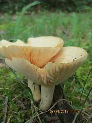
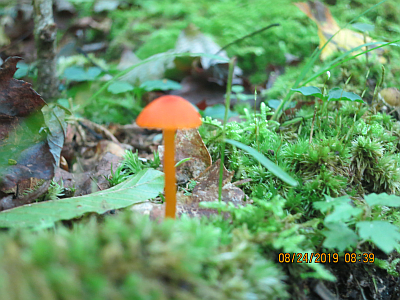
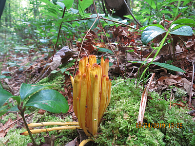
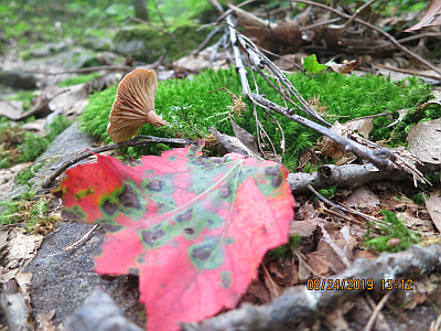
Thanks again for your suggestions. I wound up being shorter on time than I wanted and I did a good hunk of the Black Forest Trail with some of the crossing ski trails to make about a 25 mile/24 hour loop. The variation in the forest type and terrain was great: beautiful and relaxing. The weather was gorgeous and the transitions from ridgetops to stream bottoms were well planned and interesting. And so many mushrooms!

Kevin Babione BPL Member
PostedSep 2, 2019 at 5:47 pm

Thanks for the photos and I’m really glad you were able to make such a good trip out of it – I’m impressed by your “25 in 24” statistic…I’m mentally reminding myself not to hike with you, or at least not to try to keep up with you if we ever get to hike together.  The BFT is not easy terrain, so to do so much of it that quickly is truly impressive.


spelt with a t BPL Member
PostedSep 3, 2019 at 3:26 pm

Ah, the weather was good and I was rested. Now that I’m Maine I think my daily mileage is going to drop! Thanks again for the tips.

Viewing 9 posts - 1 through 9 (of 9 total)
Loading...