Companion forum thread to: Navigating Without a Compass, Map, or GPS
This article describes natural navigator techniques I’ve found helpful while bushwhacking – navigating without a compass, map, or GPS.
Topic
Become a member to post in the forums.
Companion forum thread to: Navigating Without a Compass, Map, or GPS
This article describes natural navigator techniques I’ve found helpful while bushwhacking – navigating without a compass, map, or GPS.
A note of warning on orienting with the sun. We have an innate ability to sense where the sun is even in very overcast conditions and determine a general north or south. From this we can infer a general east and west. If you do this in the opposite hemisphere to the one you are acclimatised to, you will switch east and west.
Every time I travel to the northern hemisphere I have to be on my guard too avoid this trap but I still find myself turning east instead of west and the reverse on occasions. In the recent past a skilled but poorly prepared Canadian lost his life, likely due to this effect. On the Koscuiszko Main Range he turned west down into almost impenetrable scrub rather than east and his vehicle in the face of a serious storm that brought zero visibility, high winds and snow.
I also “feel” the directions with the Sun. When I change the hemisphere I switch the feeling of directions automatically. But I have problem near the equator.
I can read maps but problem to feel distance and therefore where to turn.
One technique I use when ascending something I’ll be descending later is to stop once in a while, turn around and make a mental note of what the descent looks like. I might even build a cairn or equivalent. Without doing this, the descent always feels wrong even when I’m on the right track.
Mark, I am not following how Southern vs Northern hemisphere makes a difference. In both hemispheres the sun rises in the East and sets in the West. In both if you face East, South is to your right and North to your left. What am I missing?
@randalmartin: In the northern hemisphere, north of the Tropic of Cancer, the sun is to the south, in the southern hemisphere, south of the Tropic of Capricorn, it’s to the north. So if you are from the northern hemisphere in the US, looking south looking towards the sun, east is left. But in Australia, southern hemisphere, if you’re looking at the sun, east is to the right. If you’re using the sun as the initial reference point, that’s where the confusion comes about.
In between the Tropic of Cancer and Capricorn is different, as it depends what time of the year it is.
In the temperate zones of the USA, which would include the Catskills, the sun rises in the east and sets in the west, and shines from those directions except around the noon hour. If you’ve been bushwhacking much of the day, eyesight and the vestibular system combine to maintain a sense of those directions most of the day. Even in cloudy weather, the light from the sun usually comes from its direction, projecting through the clouds, so the brain can remain oriented. In heavy overcast, however, a compass is needed, and it is a pain to constantly have to take one out to keep oriented. It takes much of the fun out of bushwhacking.
What also gets in the way is extremely varied terrain, with numerous steep hills packed closely together, with deep ravines between them. Here around Mt Chocorua, I call the hills,”dinosaur backs,” as they look like the remains of giant beasts that have formed numerous mounds everywhere. But it makes off-trail hiking fun and challenging. Numerous huge deadfalls, not so much, especially in Colorado, where the trees grow to much larger diameters, and it is a lot of work to lift the Shelties over them. The advent of boring insects in fir trees may have contributed to this, making bushwhacking through deadfalls much like the journey of a rat running through a maze.
All the same, it is great fun to chart new routes, so long as landmarks are kept in mind, and enough time is kept available to get safely out of the forest before dark.
For the average hiker who is following a trail with a trail map, and probably a GPS, a compass is not adding much except a false sense of security. Compasses are promoted as if they are like a standby mechanical steampunk version of a GPS. You often read how a compass can “triangulate” your position. I once did some lengthy experiments on that in Yosemite, and even in that ideal environment where there are visible peaks all around you to take bearings from, you would be lucky to triangulate yourself within half a mile, assuming you have good visibility, in daylight, and have time and skill to do it. Factor in some typical “lost” factors such as it being dark, maybe cold, maybe raining, trees all around, you don’t know the names of any surrounding peaks, if any, panic setting in, etc etc, I highly doubt anyone could ever use compass triangulation to get back on a popular hiking trail. Yet they are heavily promoted and I’m sure a lot of people have picked one up at REI and popped it in their backpack under the illusion that it might be useful in an emergency.
“Compasses are promoted as if they are like a standby mechanical steampunk version of a GPS”
Moss grows on the North side of trees. Ginseng grows on North facing slopes.
“For the average hiker who is following a trail with a trail map, and probably a GPS, a compass is not adding much except a false sense of security.”
The article is about hiking off-trail. So no following a trail.
The posts I was responding to were about locating N and S without a compass.
Agree that one needs a map with a compass. I always carry a USGS 7.5 minute topo when hiking off-trail. In the Rockies, the forests are often sparse, so one can look at the map contours and features, and form a mental image of the terrain. Then looking at the actual terrain, and orienting with the compass, the direction to follow becomes clear.
But in forested areas in the East, the subject of the article, visibility is limited, and hiking off-trail is not so easy. But note from the article’s photo that the trees are well spaced, the terrain is fairly even, and moving through the forest is not difficult. But if one knows the compass bearing being followed, proceeding to the next feature on the map, like a stream or a ravine or just a sharp change in elevation, will indicate if on course.
I’ve never needed a GPS to stay on course, but carry a 3 oz Garmin 301 and mark waypoints at landmarks, in order to provide them to those who navigate by GPS.
Works for me both at home and in the Rockies.
Moss grows on all sides of trees in the Sierra, not just the North side. That rule may come from the North Woods, but it doesn’t work in the West very well.
I highly doubt anyone could ever use compass triangulation to get back on a popular hiking trail.
Hate to bust your bubble, but people have been doing exactly that for centuries.
compasses are good for going in an approximately straight line. Otherwise you’ll go in circles if you’re walking through forest.
what Dan said – as you walk along, look back to remember how to get back. Have a little fear that you’ll never find your way back, so you’ll remember.
“Hate to bust your bubble, but people have been doing exactly that for centuries.”
I doubt it. The hiking compass wasn’t invented until 1928, for orienteering. Prior to that if you wanted a bearing your main option was a pocketable military prismatic compass (not invented until around 1915), which wasn’t widely available. Prior to that , if you were wealthy, you might have a pocket-watch type of compass that could point north, but wouldn’t give bearings useful enough for triangulation.
The ‘hiking’ compass maybe, but that is a very restricted definition. The first recorded compass is from about 2nd C BCE in China. Steel compass needles date back to 8th C. Shipboard use of such compasses for navigation between China and Arabia is known from 10th C.
Cheers
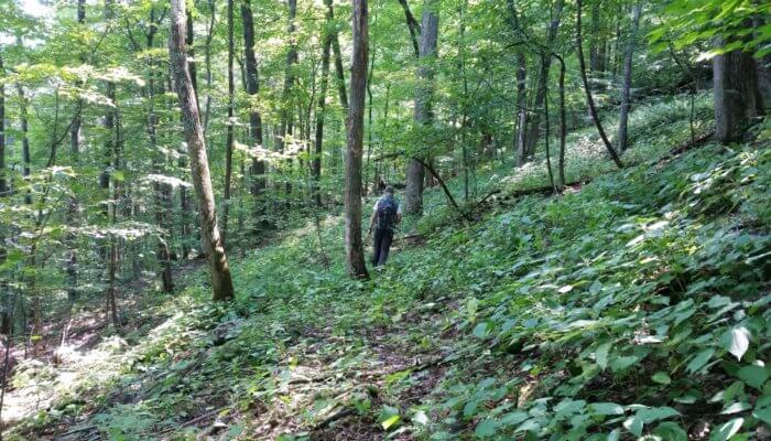
Let see how good you are by looking at your surroundings to tell what direction you are heading. What direction is he going in???
 </span> Navigating Without a Compass, Map, or GPS” />
No one going to play? Now it is hard because if you were there you would know if it is morning or afternoon but looking at the dry understory leaves and his short sleeves I say it is early to mid afternoon and he is walking south to southeast.
He’s walking “Northward” checking compass for true north.
Before we can even guess we need a general location, date and time of day because if we were hiking we would at least know that. General location is necessary as the sun direction would be different depending on if the person was in the southern or northern hemisphere.
Personally I think he’s heading uphill!
The prominent tree center mid-left appears to have some shadows on it. Thus the sun appears to be coming from the right side of the photo, perpendicular to his path. So it depends on the time of day. If in the northern hemisphere in early morning then the sun is in the east, mid-day to the south, and late afternoon to the west. I can’t say more than that…
P.S. I stink at navigation, my wife takes care of it. I walk off trails and get turned around all the time. Number one rule: she must wait for me at all trail junctions or I’ll more than likely head down the wrong path (I’m always last because I stop fairly often to take photos).
Very good Alex, I’m impressed – it was mid-afternoon and heading south. Ken
I’m not sure about centuries, but I was taught to triangulate back in my army days (1980s), and if you can see two or three known reference points, then the technique works beautifully, although it requires that you plot the azimuths on your map, so you need a projector, and a place to lay out the map, and hopefully it’s not raining. In the Catskills, you would not typically be able to see known reference points, unless you are one of the summits with a vantage point
Many places in the Blue Mts here in Oz, you would be struggling to see 50 m through the bush.
Cheers
triangulating positions with a map and compass is a requisite skill for passing Maine Guide certification. It absolutely can be done, but is also the most common cause for failing the test. As easy as it is, some people just cant wrap their heads around it.
Nobody, not in the article, not in the comments, mentioned wind. Taking note of the wind direction, and understand thermals in mountain terrain can provide very valuable directional clues. I’ve used wind when I had nothing else on an overcast day in flat swamp country and its gotten me back on course.
Nice article. Thanks
Become a member to post in the forums.
 New Ultralight GearSee the latest releases in ultralight cottage-brand gear from small makers.
 Loading...