Does anyone know of a way to automatically ‘map’ sections of a trail when you zoom in online using a service like alltrails, or gaia? I’d like to zoom in and print out a map, but at a zoomed in scale AFAIK you have to manually link the sections together by sight / estimation.
Topic
Matching map section from online services
Become a member to post in the forums.
- This topic has 5 replies, 4 voices, and was last updated 3 years, 11 months ago by
 .
.
Viewing 6 posts - 1 through 6 (of 6 total)
It’s not automatic but CalTopo does let you layout and setup multiple pages at a time. Still a manual process but about the best option I have come across.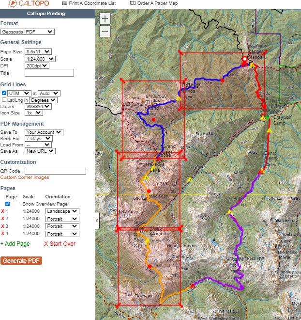
I’m not sure what the original question is exactly but I print out my pages from Caltopo like Brian shows. I think carefully about overlap and try to ensure there are landmarks visible on each page (peaks ideally).
Additionally, I often rearrange the pages carefully in the PDF before printing double-sided. I try to avoid having adjacent maps printed on the back of the previous page so that I can overlap two maps in the field.
So do you need to have a subscription beyond free in caltopo to do the multi-page layout?
Caltopo…. Free Printing, 8-1/2×11 up to 200 dpi….one page at a time.
https://training.caltopo.com/all_users/print
You do not need the Pro version to do multi-page printing. You don’t even need to login, just go to caltopo.com and start mapping. However, you will be limited to page size (8.5×11) and detail (200 dpi).
Viewing 6 posts - 1 through 6 (of 6 total)
Become a member to post in the forums.
advertisement
Garage Grown Gear Hidden Gems
Discover under-the-radar ultralight gear from small brands.

