Country United States
State Michigan
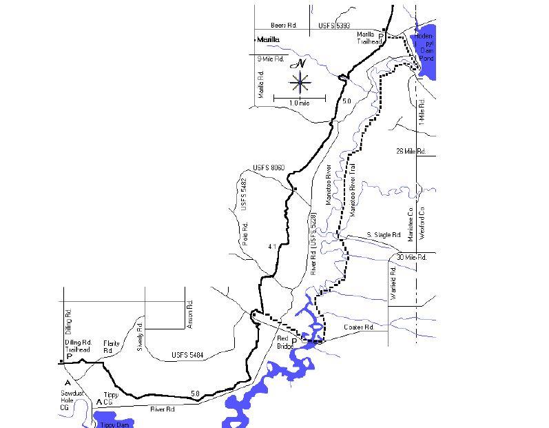
Area Manistee River Loop Trail (includes part of NCT)
Trip Month (02) – February
Report / Notes
On Feb 10 (Saturday), I arrived in Mesick, MI to do a shakedown hike for some upcoming Backpacking trips. I decided to do the Manistee River Loop Trail, which combines part of the North Country Trail (NCT) and the Manistee River Trail (MRT). I originally planned on parking at the Seaton Creek Campground, but that entrance was closed for the season. I parked at the Red Bridge River access, which is at the SE portion of the trail on N. Coates Hwy. Once you cross the road, you can either go NW towards the NCT or SE towards the MRT. I chose to go towards the NCT. Blue blazes clearly mark the trail. This time of year there were plenty of down trees from the winter, but not many crossing the trail. This section has minimal access to water as the trail is on the high side of the river, which makes accessing water in the valley very difficult. When choosing this route, you must pack in enough for the 10 miles (there may be other water sources along this route, but I had enough so I was not looking very close for it. I did not see any designated camp sites on this side of the loop, but per the NCT, you can camp anywhere along the trail without permit. There were some spots in the valleys, but again would be difficult to get in and out of. This part of the trail itself was very woodsy, offering the occasional glimse of the surrounding skyline. This section would be great in the fall months of the year. As you move down the trail, there were a few spots where you cross access roads, but I found everything to be clearly marked. As I reached the halfway point, you will start to see folks fishing in the area as the river is a great spot for fly fishing. As you approach the bridge, you start to see camping areas. You must cross a suspension bridge to get to the MRT side. This is actually the start of the trails if using the alltrails app. Once you cross, you are on the low side of the loop and water is present everywhere. As you hike, the fast moving river is on your right and you will cross a number of creeks with moving water. The river is a fast moving river, so do not fall in. This side of the trail, I felt was not as clearly marked. There were some white blazes on some of the MRT and some areas that are marked with blue diamonds. At this point, I was looking to camp. The campsites on this side are clearly marked with a letter and number. Sometimes, I felt that the trail was not clearly marked around the sites, but once I saw the campsite, I managed to pick up the trail. The blazes are not typically where you can see one from another. Sometime I had to walk a little before I saw another one. Only on one occasion did it throw me off trail, but the apptrails app got me in the right place. There are signs in some aeas stating no parking or camping. This part of the trail is being managed by Consumers Energy, who is managing the dam for the river. The campsites were magnificent, with fire rings and flat surfaces to pitch a tent. Trees were plentiful for those with hammocks, but the campsites were cleared for tent camping. This side of the trail was much more rewarding from a hiking standpoint. I was very sore and tired from the day before, but it did not stop me from taking pictures. We have had an early snow melt in this area, so water from the top was streaming down so that you could see a few small waterfalls with good moving water. Cell phone coverage was limited, but the Alltrails app (free version) always allowed me to navigate.