Topic

Looking for Kern River Hot Spring via Mineral King station info


Forum Posting

A Membership is required to post in the forums. Login or become a member to post in the member forums!

Home Forums Campfire Trip Planning Looking for Kern River Hot Spring via Mineral King station info

Viewing 3 posts - 1 through 3 (of 3 total)
  • Author
    Posts
  • #3707181
    Marcus
    BPL Member

    @mcimes

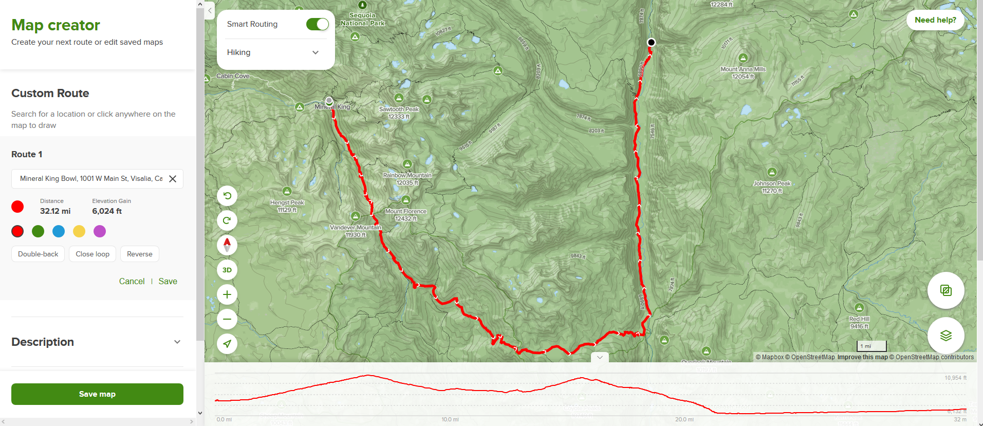
    I want to get to Kern River Hot spring via the Mineral King ranger station. Sounds like to go over Franklin pass then descend into the Kern river valley.

    Anyone done this hike? Feedback? pitfalls? anything unexpected? worth the effort?

    when does the pass usually clear up from snow?

    What are some average high/low temps to expect in mid april/may/june/july?

    How much water do you need to carry off the trailhead? what’s the longest stretch you have to plan without water?

    Its approximately 20 miles and 6k vertical each way, thinking I would probably need to do 4 day/3 night trip with a night at the half way point unless I felt real crazy. I’ve done 20 miles in a day but that one only had ~1600 vertical. Blisters were a major problem, but I had a 36lb pack and I’ve since cut my pack weight to about 25lbs with a 20* bag, 2L water and 2 days of food so maybe I could get closer to 15 miles on the first day. I just did 10 miles/4k vertical on a quick overnighter last weekend and had more to give with that exact setup.

    If you’re familiar with the greater Sierra National Park area or this particular hike, chime in!

    Thanks in advance


    #3707406
    John Vance
    BPL Member

    @servingko

    Locale: Intermountain West

    I haven’t done that hike since 1982.  Did 1.5 days in and 1.5 days out with a day exploring the river and soaking in the hot spring.  Very enjoyable and worth the effort.  Saw one person the whole trip that was fishing along the Kern.  I am sure it’s more crowded now.

    #3708121
    Marcus
    BPL Member

    @mcimes

    I am making an AllTrails custom map as there is no official trail to Kern Spring I can discern.

    This route gets there, but is 30 miles/7.5k vertical and other articles refer to a path that is about 20 miles/6k vertical. Is there a path in the valley (indicated by the dashed red line) to follow? Or is the stream bed walkable? Or can anyone point me to the best path to Kern Spring? Here are my options as I see them now –

    North Route – 31 miles, 7500 vertical. Not Ideal because the end of day 1 would likely leave me above the tree line and I hammockKern Spring custom route 1

    South route 32 miles 6000 vertical. This could work, as 15 miles gets me off the ridge, but 32 miles is still farther than ideal.South Route


    Here is my ideal route, but the section in blue does not show a trail there. its 17.5 miles with 4600 vertical. If anyone knows this area, do you know if the stream bed is walkable? It looks like about 3.5 miles in that valley, but that cuts off 13+ miles compared to the North or South loops. I think I could do this in one day

    Ideal Route (proposed)

    Here is a closer detail of the area in questionNo Trail detail


    Last, how hot is Kern hot spring? Sespe is burning hot at the source and you have to go down stream a ways to find a nice pool. Is Kern at least hot tub temp (>104*)?

    Thanks!

Viewing 3 posts - 1 through 3 (of 3 total)
  • You must be logged in to reply to this topic.
Forum Posting

A Membership is required to post in the forums. Login or become a member to post in the member forums!

Get the Newsletter

Get our free Handbook and Receive our weekly newsletter to see what's new at Backpacking Light!

Gear Research & Discovery Tools


Loading...