Topic

June Stream crossings on JMT?

Viewing 19 posts - 1 through 19 (of 19 total)
PostedJan 13, 2016 at 4:15 pm

If I can generalize, how bad can the stream crossings typically get on the JMT or HSR in June? I know it varies by year/snowfall etc. Asking for the typical worst (75% worst).

I’m comfortable with slow moving 100-200 foot crossings, slow moving shoulder depth. I am uncomfortable with “Blasting” white water more than 12″ deep that I can’t Jump across. White water that’s not blasting in class 1 terrain I might be willing to try. I have no idea how to evaluate snow bridges.

Any pictures would be appreciated. I have tried google images but the JMT stream crossing pictures appear to be late summer crossings because they look like nothing.

Thanks!

Matthew / BPL Moderator
PostedJan 13, 2016 at 6:38 pm

Last June I encountered swift water at about knee depth at Bear Creek. It was cold as hell and pushed strongly but not white water. Evolution Creek was broad and fast but mid-shin depth on my 5′ 6″ frame. I was keenly aware of what was downstream but the water was less intense than Bear. Both crossings happened in the last week of June.

I crossed both both creeks with my 12 year old.

I’m sure you know last year was a dry year although it had some late snowfall that was melting off rapidly. I can’t offer any historical perspective… It was my first time in the Sierra.


PostedJan 13, 2016 at 8:11 pm

That sounds pretty low-key… wondering why people say June is less than ideal.

jscott Blocked
PostedJan 13, 2016 at 8:14 pm

Mathew: it gets much worse than that.

The op is comfortable in shoulder deep water? Wow.

Streams in the Sierra are very clear and cold. What looks to be shallow water can be quite deep; similarly, what seem to be slow currents can be surprisingly strong. Finally, stream bottoms can be very slick.

I once spontaneously broke out into Amazing Grace while crossing the waist deep Evolution Creek in June. I would expect it to be running much higher than mid-shin depth this year at that time; we’ll see.

But Evolution isn’t the worst.

I worked trail crew for four years in the PNW. I’ve hiked for many years in the Sierra early season. I’m pretty experienced with stream crossings. I don’t like them in high runoff years.

This year is shaping up to be a high snow year. People will be reporting about streams. I would look into these reports.

Paul Wagner BPL Member
PostedJan 13, 2016 at 10:18 pm

You cannot judge this year by last year.  There was no snow last year.  Streams were unbelievably low last year.  This year will be different.  And fast water is the single biggest killer of people in Yosemite as well as other backcountry areas…

Matthew / BPL Moderator
PostedJan 13, 2016 at 10:21 pm

I was rushed when I answered at first. When I made my comment about not having historical perspective I meant that I am inexperienced and that last June surely doesn’t represent all Junes.

Ralph Burgess BPL Member
PostedJan 13, 2016 at 11:07 pm

Yup, I was out in June last year, and levels were freakishly low – similar to an average August or September.  Extensive rains then stopped things getting too parched later in the summer, but it’s primarily snowpack level and temperature (i.e. when the melt peaks) that determines when you get the highest levels.

2016 snowpack so far (about halfway through the season) is right on the average, look at the pink line vs the black line here:

http://cdec.water.ca.gov/cgi-progs/snow/PLOT_SWC

In June, there will still be substantial snowfields to cross on the passes, and snowmelt will likely be peaking.   There will be many people out on the trail already by then to give reports – PCTers start going through in May.   I will be hiking most of the JMT myself in the snow in mid-May.  Look out for trip reports here and on the JMT Yahoo group.


Dan Magdoff BPL Member
PostedJan 14, 2016 at 4:35 am

crossings can get real bad in June.  I have some pictures of some bad stream crossings in Kings Canyon in June 2010.  But not really sure how to upload the pictures onto here….

Matthew / BPL Moderator
PostedJan 14, 2016 at 6:18 am

Dan, I sent you a PM. I can resize and post photos if you want to email them to me.

Dean F. BPL Member
PostedJan 14, 2016 at 8:00 am

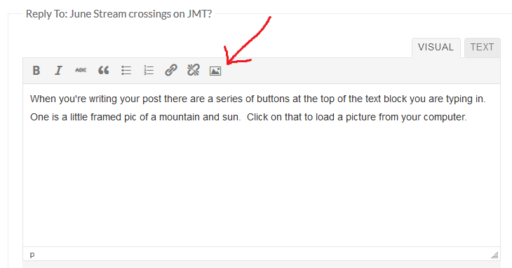
When you’re writing your post there are a series of buttons at the top of the text block you are typing in.  One is a little framed pic of a mountain and sun.  Click on that to load a picture from your computer:

When you do a box will open.  Click the Browse button to select the picture file to load:

Once you select the file, click the Insert Image button.  I’m pretty sure that the new forum re-sizes pictures automatically.  I’ve loaded some monsters, and they get shown smaller in lesser quality.

PostedJan 14, 2016 at 8:39 am

Yeah, I understand the wisdom behind “wait and see”. I’m asking though because June JMT permits need to be requested in January. : )

I’m really interested to see those photos you have if you don’t mind sharing. I’m specifically interested in Depth, width, and water speed. If I were less of a noob, I understand kayak/rafters have a really good handle on flow rate terminology but it’d honestly be just a number to me.

jscott Blocked
PostedJan 14, 2016 at 9:17 am

There will likely be a big difference between early June and late June.

I’m betting on an above average snow pack this year. But who knows?

Paul Wagner BPL Member
PostedJan 14, 2016 at 9:33 am

We just got a permit for Yosemite in late June, and plan to head into the high country…so we’re hoping/planning that snow level will be normal or so…

jscott Blocked
PostedJan 14, 2016 at 5:02 pm

Yosemite will be doable for sure. No worries; at worst, you can route around big crossings but I doubt that you’ll have to do that.

But here comes El Nino; we ‘might’ get 120-130% of normal snow levels, based on historical precedent for these types of large El Ninos. Keep tabs and factor that in.

do you have a specific itinerary or is it a general permit?

Paul Wagner BPL Member
PostedJan 14, 2016 at 8:23 pm

No such thing as a general permit for Yosemite–you need to specific starting date, ending date, entry trailhead and exit trailhead.  We’re heading up into the upper canyon of the Merced, but we always keep our options open…


jscott Blocked
PostedJan 14, 2016 at 10:08 pm

So past Merced Lake and then on towards Triple Divide? Or up towards Vogelsang? either way I can’t picture any stream crossing problems, unless the bridge over the Merced that went down some years ago–but it still functional–washes away. Maybe they’ve fixed it though. The upper reaches of the Merced (Triple Divide)_is a piece of cake no matter what, really.

but if you circle back on the ‘high route’ and have to cross the Lyell fork, take care. There’s a better crossing upstream from where the trail meets the river–which can be white and dangerous.

Once you’re in the park, you have a good amount of leeway to change your itinerary.

Matthew / BPL Moderator
PostedJan 14, 2016 at 10:08 pm

Craig, someone just posted video of the Bear Creek crossing from 2011 on the JMT Facebook group. Are you a member there?

PostedJan 15, 2016 at 9:23 am

Matthew-Thanks for the tip. I’m not a member of that group but I used the description and came up with these too videos that seemed helpful:

Youtube video

https://www.youtube.com/watch?v=H8rdE2-ddIA#t=128

That water’s definitely a little faster than preferable, but not “blasting” or in terribly dangerous terrain. Seems like an acceptable risk especially if you put the sleeping bag in a semi-waterproof bag.

Edit: Digging thru the videos Picker’s video appears to have been a July video which presumably would be better than June. How much worse does it get in terms of depth in June? This looks like upper thigh/waste depth.

Matthew / BPL Moderator
PostedJan 15, 2016 at 1:45 pm

Again, I’m not the expert but I don’t think you can generalize about any particular month. At least not this far out. That said, this is looking like at least an average year for water content…

I realized last spring that I had to let go of trying to anticipate and control our trip. I knew it was possible that we would turn around at Bear or Evolution at the chute on the south side of Forester. I was watching videos of the first PCTers going over Forester just a couple weeks before I got there with my kid.

My advice is to go later in the summer if you want a near 100% chance of favorable conditions or have contingency plans in place if you need to go earlier. I had to go in June due to my work schedule so we took the latter approach.

The JMT Facebook and Yahoo groups will be full of videos and reports from the first PCTers. Also listen to John Dittli (among other things he does snow surveying) and Ned Tibbets (he will be in the mountains in April and May as the director of Mountain Education… They do snow training).

Have fun. It’s a great walk.

Viewing 19 posts - 1 through 19 (of 19 total)
Loading...