Topic

Help me pick a trail in the Carolinas

Viewing 17 posts - 1 through 17 (of 17 total)
Sanad Toukhly BPL Member
PostedOct 1, 2019 at 5:06 pm

Hi everyone,

So I’m visiting family in Charlotte, NC in Mid October and I will have about 7 to 9 days to go on a hike. I’m looking for really nice scenery and high elevations. I usually hike 18 to 22 miles a day on the AT so this gives me 160 to 200 miles of trail to hike. I would rather not to drive more than 5 to 6 hours from Charlotte so I would prefer it to be in the Carolinas. Also, I’ve already hiked the Smokies several times so I would like it to be something else. If you suggest a one way trail, if you could please suggest a good shuttle service to take me to the other end of the trail if it’s available.


Thanks in advance for your suggestions.


Sanad

Tipi Walter BPL Member
PostedOct 1, 2019 at 5:20 pm

I’d leave Charlotte and drive up to Morganton NC and get on Highway 181 heading north and park somewhere safe where you can access the Mountains to Sea trail which runs from Linville Gorge east to Steels Creek, up to 181 crossing, down to Upper Creek, up to Raider Camp Creek and across Harper Creek to North Harper and over to Lost Cove Creek and Gragg Prong.

While this main route can be used—you can put in more miles by hiking adjacent trails in the Wilson Creek backcountry—like Timber Ridge and Lost Cove Creek upstream—and pull loops and back and forth treks.

You could spend several days just on Upper Creek and basecamp by Burnthouse Creek which jcts Upper Creek and go exploring down Upper Creek to it massive rock canyon gorge—a beautiful place.  And there’s a way to tie in Upper Creek 268A trail into the MST/Greentown trail.

If you need more info let me know.

Russ W BPL Member
PostedOct 2, 2019 at 10:28 am

+1 to Tipi’s advice…that’s where I was leaning. He is semi-famous in these parts and would know the details.  I know for sure I can get lost in the Linville  Gorge for several days.

Let me know dates and if I’m around perhaps I can help you with a shuttle.

Russ
<p style=”text-align: center;”></p>

Alex H BPL Member
PostedOct 2, 2019 at 11:13 am

Not sure you would get the miles in you want with only Tipi’s suggestion.  You could do a very interesting high altitude semi loop starting at the north end of the Black Mountains over to Mt. Mitchell to the Mountains to Sea trail, east to Linville Gorge, then the Wilson creek area over to Grandfather Mtn and over the top there and end on the other side, it would be about 110 miles without side trips.  About as high altitude and views as you can get in the east combined with some beautiful water and gorges.  You wouldn’t be able to do AT type miles as it is more up and down and less graded.

Sanad Toukhly BPL Member
PostedOct 2, 2019 at 7:57 pm

Thanks guys, those are great suggestions. I’m leaning towards Alex’s suggestions  for the higher miles. Do you know which map I could get for these trails so I can plan my hike? Also, are these well marked trails or will I need a gps unit? I’ve only ever hiked on the AT in the Carolinas so I don’t know much about the other trails and how they connect.

Russ W BPL Member
PostedOct 2, 2019 at 10:50 pm

I’ll throw this out to my buddies and see if they can provide suggestions.  I was interested in Alex H. suggestions and would agree that the areas mentioned ared spectacular and varied. Gorge miles are different, i.e. roots and rocks and such…not 20 mile days.

My offer of shuttle (depending on schedule) stands.

obx hiker BPL Member
PostedOct 3, 2019 at 1:57 am

Here’s a loop combining the NC Mountains to Sea Trail and the Art Loeb Trail.

https://caltopo.com/m/5KSG

Art Loeb Trail:  https://www.hikewnc.info/trailheads/pisgah-national-forest/long-distance/art-loeb-trail/

MST: https://mountainstoseatrail.org/

It’s maybe 140-150 depending on side hikes to 6K summits.It has quite a few “ridge runner” stretches that you can pump out miles but also some more up and down sections that’ll lower your mileage some and if you do some side-hikes to the summits that’ll also lower your mileage, plus there’s more stuff you might want to pause and take in; it’s not so much of a “green tunnel”   https://www.carolinamountainclub.org/index.cfm/do/pages.view/id/23/page/South-Beyond-6000

There is also 4 or 5 sections of Old Growth along this route as well as several waterfalls. I’d start and end at the Davidson River fish hatchery also called the Pisgah Center for Wildlife Education.

You won’t need a shuttle. It’s about 2.5 hours from the I-77 and US 74 intersection in Charlotte according to google so not too far away. Lots of variety; everything from cove hardwoods to balds to Spruce-Fir-Balsams and lots of great views. Also plenty of good camping spots.

The area right around Black Balsam can get a little busy on leaf color October weekends. Also you’ll need a bearcan. Very Good tread (esp. compared to lots of the AT) and well signed except the Fork Ridge Trail and then the trail up the ridge over Green Knob to the MST at Mt. Hardy (the blue section on the map). Still a map will do. Just blow up and print parts of the linked one or if you have a gps app you can import it from Caltopo.

If you decide to tag the summits I’d recommend reading the SB6K website and also waypointing those with some type of gps. It’s hard to tell when you’re at the top on some of these and the vegetation and downed timber etc. can make it hard to navigate; especially thinking about Reinhart, but also Chestnut. Many of the others are pretty much out in the open. You might also want to take a photo of the USGS benchmarks on the summits that have one. These show a triangle mark on the map; like for example Cold Mt.

If you’re interested I’ll mark to old growth spots later as well.

Edited to add.I think from Sam’s Knob you can just about see all of the other 30 including the whole length of the AT ridge in the Smokies, the Plott Balsams, the Craggies and the Blacks. Probably not Roan. It’s just too far away.

Sanad Toukhly BPL Member
PostedOct 3, 2019 at 3:55 pm

Obx thank you very much, that seems like a great route. I will probably use the Gaia gps app on my phone in addition to a map. Is Caltopo the best source I can use to print out a map? I have time to order one online that is waterproof if someone can recommend a good one. You mentioned I’ll need a bearcan around Black Balsam, is that by law? Could I get just bear bagging? I don’t have a bearcan nor any room in my pack for it.


I’m torn between the route Alex suggested and the one Obx suggested. Will I see similar scenery with either one?

Alex H BPL Member
PostedOct 3, 2019 at 5:16 pm

Similar scenery but my route has more water on it.  It has been some years but the Green Knob trail was really over grown and hard to follow but the rest of obx’s route is pretty easy to find.  The Nat. Geo maps have all of both routes, two different maps though.

My route is all well trod and generally marked, the area through Wilson creek has a lot of trail junctions to keep an eye on.

obx hiker BPL Member
PostedOct 4, 2019 at 1:10 am

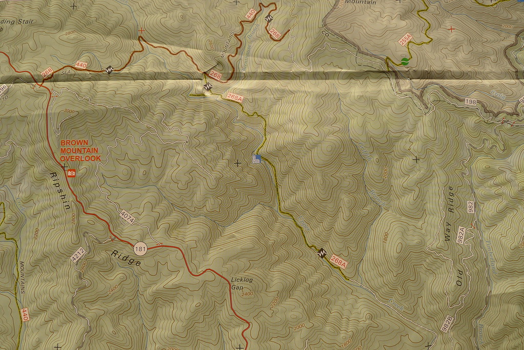
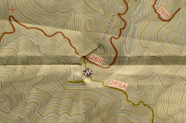
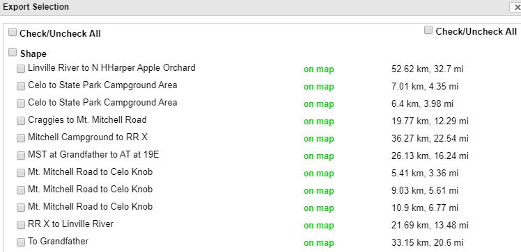
I added a version of Alex’s route to the map linked above; with the difference (I think) being approaching the Blacks from the south via the Craggies vs.the north via Celo or in the Middle by the state park?  This route tags Celo and thereby the entire Black Mt. crest by doing an out and back along @ 6 miles of ridge (gorgeous and worth it imho. Highest ridgeline east of the Black Hills of South Dakota)

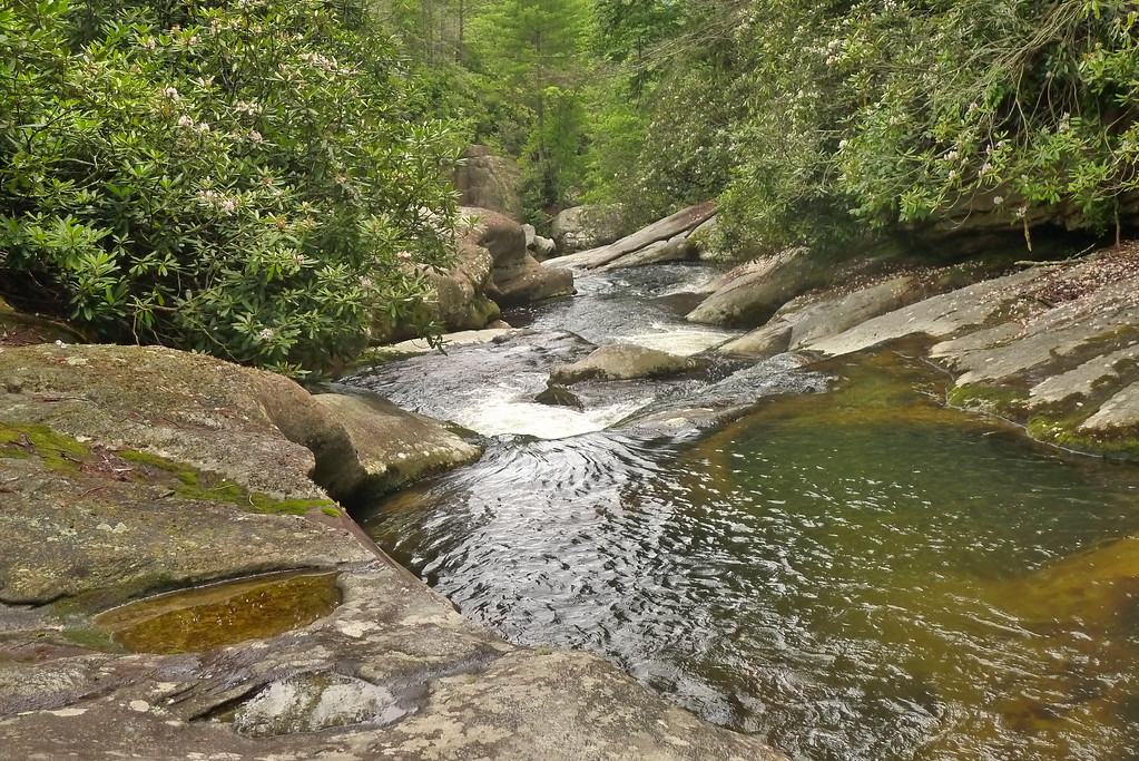
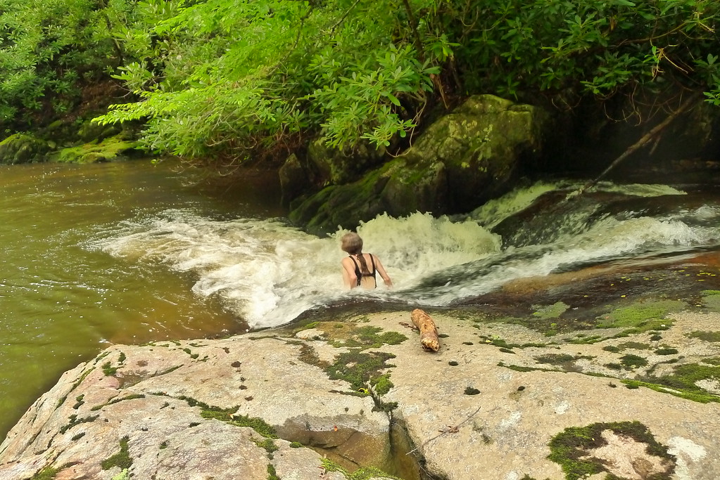
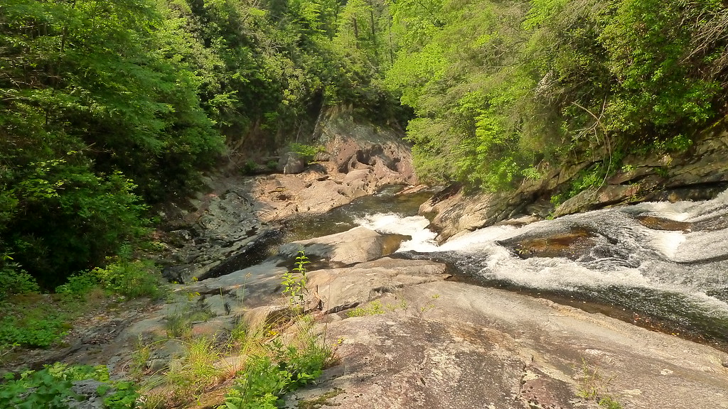
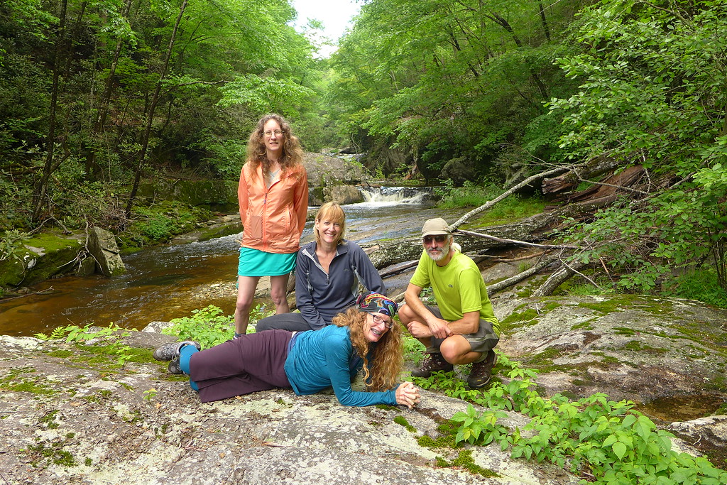
There is more water on this north route which indeed has more water, normally; than most places outside of the N. Cascades or the Olympic peninsula ;)  I understand it’s been a wet calendar year but very dry since some time in /@ August. Maybe someone can chime in with some recent info? There’s a  Big concentration of waterfalls in the Wilson Creek area, or really all along from around Table Rock to Grandfather Mt. My avatar is a photo of a brother and daughter in one plunge pool right beside this route on Gragg Prong which is practically one continuous waterfall. I think this route also includes Walter’s gorge in Upper Creek as a slight detour. Walter might verify that. I’d also recommend a detour to Hawksbill which entails a short road walk on a forested gravel 1.5 track USFS road.

The north route also gives you the opportunity to tag maybe more than a dozen SB6K peaks and their site linked above again has details.

Alex is also correct that the Green Knob section is a little fuzzy; basically the last mile before it intersects the MST. People go up there from the parkway to pick berries and there are (or were) some braided trails right @ the MST junction. As you can see on the map there’s another trail up the watershed just SW of and parallel to the ridgeline route. The watershed route climbs more gradually. The ridgeline route is steep the first 2 miles and then more level. I just think the Green Knob ridgeline route is more scenic. By the time things get “fuzzy” you’re pretty close to the MST so with Gaia there shouldn’t be any problem. There are also a couple of intersections along Fork Ridge with local use trails so that stretch bears paying attention to, as does the route from the Linville River all the way to Grandfather as zooming in on the Caltopo map will show. The MST website is a good resource. As Alex noted both the MST which is also a majority of the north route, and the Art Loeb Trail are in good condition and well marked.

Your Gaia app should be able to download and incorporate any Caltopo map. May eat up some bits/memory. I find it to be a very good app with a quick fix on location.

Walter may be able to confirm I got the Upper Creek section and may have some additional insights as may Alex. I have not done most of the stretch of the MST from the Mitchell campground area to the Linville River but familiar with most of the rest.

I’d carry the bearcan in the Southern route. It’s required in the area @ Black Balsam out to Shining Rock as per: https://www.fs.usda.gov/detail/nfsnc/alerts-notices/?cid=stelprd3832543

These guys rent bearcans in Brevard:  https://pvadventures.com/    Contact@pvadventures.com

The northern route any way you do it (starting at Mt. Mitchell, the Craggies or Burnsville area) is going to require a significant shuttle.

Wish there was a way to connect the AT with the Blacks. and the MST. Boy could you create some loops if the MST was connected to the AT from the Grandfather/Roan areas. Only 16 miles by road from the MST at the parkway at Grandfather to the AT crossing on 19E.  There’d be possible loops all the way down to Murphy, plus I guess you could turn east off the AT and take the MST all the way to Hatteras!, or even right to my backyard!-.

These folks are doing some good work that might even help make this more possible: https://appalachian.org/

One reason I keep talking about the SB6K is that doing this “challenge” unexpectedly taught me a couple of great lessons. The first unexpected benefit was I learned to recognize  the layout and arrangement of pretty much all the mountain ridges in NC; a goal I had unsuccessfully tried to accomplish by other means. But an equal  and also unexpected benefit from doing this was how it really improved my ability to travel off-trail in heavily wooded mountains in situations where you often have very limited visibility and can’t rely on a landmark for orientation. It’s nice not to have to rely on a trail.

Tipi Walter BPL Member
PostedOct 4, 2019 at 4:04 pm

If I was gonna go an “expedition” style backpacking trip for 10 or more days I’d head to the Wilson Creek area and play around on these creeks—which are all connected together by foot trails—and all of them have awesome waterfalls—

Steels Creek
Upper Creek
Phillips Branch
Raider Camp
Harper and North Harper Creek
Lost Cove Creek and Gragg Prong.


Steels Creek is on the East side of Hiway 181 (the Linville Gorge side) and has a trail (MST) for a couple miles of its length and passes thru several rock canyons as this pic shows.  It’s a great place to backpack and set up camp.


Upper Creek is my “baby” and it’s marked with the Trail 268A number.  The blue waterfall sign is the Upper Creek canyon “gorge” which deserves a visit as there’s a CS where Burnthouse Creek jcts Upper Creek.


This pic shows where Burnthouse Creek jcts Upper Creek.  (The trail actually is lower and crosses Burnthouse Creek right next to Upper Creek—where there’s a great CS).  And the “stopped” trail actually continues on Upper Creek after you cross one time and get on the west bank with a continuation of 268A to where it merges with 268 which is the MST/Greentown trail.


If you want a real trek you can camp where Burnthouse jcts Upper and then dayhike up the side of Burnthouse Falls and reach this precarious spot high above Upper Creek.


And right next to Burnthouse/Upper CS there’s this awesome swimhole for water sports.


If you leave the CS and bushwhack down Upper Creek (there are two ways—easiest is to just stay in Upper Creek and head downstream)—you’ll reach Upper Creek canyon gorge as pictured.  This is just part of it.


Me and my backpacking buddies have been going to Upper Creek since 1984 and so we all got together for a reunion tour in 2016.  This pic was taken on the rocks at the start of the canyon gorge.

Sanad Toukhly BPL Member
PostedOct 4, 2019 at 4:19 pm

Thanks a bunch Obx, the maps really help. What is that 16 mile section you marked from Grandfather Mountain going east?

Also thank you Alex for the route you suggested. I think I will try Alex’s route because I would just hate to have to carry a bear can. My pack is way too small to fit it inside and strapping it to the outside would just throw my balance off as I like to move fast. According to Obx’s map it’s about 130 miles without detours, and once I add some detours that should give me enough miles to fill up the rest of my time.

Russ, I’ll take you up on the shuttle offer. I will PM you.

So a few questions I have about Alex’s route:

  1. Would you recommend NOBO or SOBO? Or does it even matter?
  2. You guys mentioned there is a lot of water along the way, are these mostly rivers and waterfalls or lakes and ponds? Are they accessible most of the time so I can collect water to drink?
  3. What kind of average low temperatures should I expect this time of year? Most weather websites are telling me low 40’s. Is this accurate?
  4. Will bugs be an issue? I’m guessing the answer to this is no but I just want to make sure.
  5. If I want to see more fall colors, would you recommend I start my hike on the 11th or 18th of October? I was reading online that near the end of October most of the trees are bare so I’d rather start on the 11th if that’s the case.

Thanks guys, you’ve been a ton of help!


Alex H BPL Member
PostedOct 4, 2019 at 9:22 pm
  1. Direction might depend on the weather but either end starts with day of high ridge.  The west side trail on Grandfather is unrelenting straight up for the most part and I would prefer to go down it with a light pack.  So my choice would be NOBO.
  2.  The Black Mtn. crest is pretty dry (~ 8 miles between good water sources) but you can get water at the state park on the top of Mt. Mitchel before hitting the M2S, the rest will mostly be creeks and rivers.  Similarly there is only one water source part way up the east side of Grandfather Mtn..  The intense short drought will have most of the ridge sources dry or low, I just saw a report for the Roan ridge and most of the springs were dry.
  3. You will probably have some 30’s
  4. No bugs
  5. It has been tremendously dry and warm here down in the Piedmont and the leaves are just turning brown and falling off the trees, that said probably the earlier start.  Here is a recent article on the drought and timing of leaf color

Here is a trip report for the Wilson Creek/Grandfather section I did in August, if you look around my site there are several Mt. Mitchell/Black Mtn. crest reports but here is the one starting from the north end on Bowlens Creek.


obx hiker BPL Member
PostedOct 7, 2019 at 3:30 am

“What is that 16 mile section you marked from Grandfather Mountain going east?”  I think you mean going west from the base of Grandfather . My bad. I was marking to measure the distance by road from the MST at Grandfather to the AT at 19E.

I’ve changed the route color on the map to purple so it won’t conflict with anything else. I also changed the part coming from the Craggies to the Blacks to green so that shows the southern approach separately.

And I added the stretch from Bowlens Creek to Celo. Also colored in 2 ways to get from @ Mt Mitchell summit back to the MST as an orange loop. I’d take the route south along the ridge to Stepps Gap just to stay up high a bit longer; though the section from the ridge down to Camp Alice is a boring road walk.

Alex is right you’ll want to be careful to have water on protracted ridgeline walks. Load up low at Bowlens Creek. The long stretch from The BR Parkway over Woods Mt. to 221 is liable to be dry The stretch from the Railroad crossing over the N Fork of the Catawba over to Linville River only crosses 2 blue line streams, one high up ( might be dry) and the other near the Linville River. I’ve not done those stretches so I don’t know for sure  Also the stretch across the Linville River over Shortoff Mt. to the Chimneys and Table Rock might be a little dry. Once you get to the first stream just north of Table Rock there’s plenty of water.

OTOH you will cross quite a few streams and the Linville River so you will get wet feet. I’ve had success replacing socks wet from crossings with dry socks and covering those with a grocery bag until the trail shoes dry out to help keep my feet dry and avoid blisters and the macerated feet etc described in a current thread. Whatever you do in those situations or read up on this forum.

Finally the bottom half of the climb from Bowlens Creek up to Celo is steep. You get a break where the trail/road passes a curious and unusual large and deep hole in the mountain on trail right. Locals tell me the hole used to be a Mica mine and was in use until @ WW2. I’m not sure what the mica was used for. Maybe stuff like welders goggles before tempered heat resistant glass was invented; or “window” openings for furnaces and stuff like that. Anyway it’s a curious and deep hole. There’s a level stretch after that with some views right and then another tough climb until you break out into the open near the summit of Celo. All the climbs from valleys along the Black Mountains to the Crest are good climbs. A good way to get started.

Happy Trails!

Sanad Toukhly BPL Member
PostedOct 7, 2019 at 12:10 pm

Thanks for the answers guys.

Obx: It’s a good thing you let me know about the stream crossings Obx, I wasn’t expecting that. Thanks for updating the map. Can you let me know how to download it to Gaia?

Alex: I wasn’t expecting temps to go down in the 30’s, I was hoping to get by with a 40 degree quilt. I’ll have to bring some extra insulation.

How much rain should I expect this time of year?

Alex H BPL Member
PostedOct 7, 2019 at 2:58 pm

Spetember and October are the two driest months of the year here, statistically and our first frosts arrive early Oct. in the mountains, if not sometimes earlier.  We haven’t had rain here in the Piedmont for a month.

obx hiker BPL Member
PostedOct 7, 2019 at 7:14 pm

I’m relatively new to Caltopo so I’m sure there are people on this forum who are much better at using it and they might add some info if they are reading this thread.

That said here’s what I can figure out. Zoom in on the north portion of the larger map that shows the route and get as close as you can to JUST showing the route.

On the menu bar above chose the Export down arrow

The above is what you will see. You want to export 9 of the eleven green ” on map” segments excluding the MST at Gfather to At-19E and the Craggies to Mt. Mitchell Rd. segments unless you change your mind about that…. The segemnt from the Craggies to Mt. Mitchell is really scenic but moving along…

Export these as .gpx files to some place like your spot on the cloud, whichever cloud, or maybe even a thumb drive.

Then import them into your Gaia App on your phone. That should be it.

by the way: When making that map I was not taking the most minute and careful attention with the start and finish of segments. There are some random track points especially at some of the segment ends where evidently double clicking the mouse to end the segment causes the pointer to jump and you get some stray tracks.

You should be able to figure that out pretty easily and you might even delete them from your Gaia app. Why not.  And BTW 2. The route I show has you ending up at the parking lot off the road to the swinging bridge. I think Alex’s route maybe ends up down at the parking lot  for the Profile Trail down the mountain off of 221. If you’re meeting a shuttle be sure you’ve got that end point settled.

Viewing 17 posts - 1 through 17 (of 17 total)
Loading...