Heard a rumor that the Halfmile PCT maps were no longer going to be free in 2020.
from Backpacking Light
Ultralight Gear at REI?Find needles in the haystack in the BPL x REI Gear Guide.Topic
Halfmile PCT maps gone in 2020?
Become a member to post in the forums.
- This topic has 5 replies, 5 voices, and was last updated 6 years, 5 months ago by
 .
.
Viewing 6 posts - 1 through 6 (of 6 total)
https://www.pctmap.net/maps-url-loading/
Might be worth grabbing a copy now.
Better download soon:
Halfmile’s PCT map .pdf files are being replaced by the new National Geographic PCT maps. The old .pdf map files will no longer be updated and will be removed from this web site at the end of the month.
The National Geographic version will be better printed of course (basically better water resistant paper, better inks) and likely updated to the most recent changes in path. Think Halfmile stopped updating for the public 2 or maybe 3 years ago. I know the trail shifts a little every year (this year at the north of Jefferson Park in OR).
Then there’s that seismic shift being planned for adding 30 miles at Tejon Ranch … eventual.
My concern isn’t that a free map resource is now a paid resource. Anyone who’s done freelance work will agree that a person’s time is worth something, and if the Halfmile maps were strictly a sole endeavor by a single person then he deserves to be paid for all his hard work.
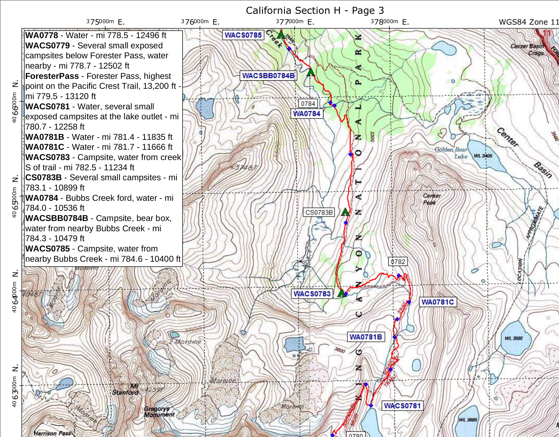
My concern is over the map data. Shown here is a sample of a Halfmile map, and what was excellent about it were the waypoint notes on each page. Details about water sources, campsites, trail junctions, and passes were listed.
I see no evidence that the Trails Illustrated maps will provide similar notes, but I could be wrong if they are planning new editions of their map booklets that contain this information.
The only other source I’ve found for such notes is Elizabeth Wenk’s databook and companion data files for the JMT, which themselves are companion books to her JMT trail guide.
Do other hiking destinations have trail maps with similarly exquisite detail about campsites, water sources, etc? I’ll admit that I haven’t studied any AT, CDT, or other National Scenic Trail guides to say one way or the other.
I’ve hiked in other places, like the Wind River Range, where I didn’t feel I needed such detailed information. The two times I’ve hiked along the JMT, I felt like the circumstances were somewhat unique: I was leading a small group that contained several beginner level hikers. Our itinerary was easy for some but pushing the limits of others. Given how busy the JMT can be, arriving at an intended campsite late in the day to find it already occupied provided challenging decision making: do we continue hiking in the hopes of finding unoccupied campsites 2-3 miles farther down the trail or do we bushwhack to an off trail area that the topo map suggests could provide camp locations? We ran into this exact situation this past August hiking from Sally Keyes Lakes to Bear Creek. It had been a hot day and folks were tired, even though it wasn’t very late in the day. ( We’d only been in the High Sierra for 2 or 3 days and we low elevation dwellers take time to adjust to hiking at altitude. ) All the sites we passed were already occupied. We tried doing some recon to find some unmarked flat spots, but the area east of the creek gets steep quickly, and the creek is almost impossible to cross anywhere near the Break Creek Trail junction. We headed down the Break Creek Trail toward a small hilltop indicated on the map about 400 meters west of the JMT. It looked like it might have reasonable camping, but the trail in this area was SUPER wet and overgrown so we turned back. We ended up camping at a well established campsite about 100m west of the JMT, but its location came up slightly short of USFS recommendations for distance off a maintained trail and distance away from water sources.
I understand that most thru-hikers would rarely find themselves in this type of situation. They’re stronger hikers that don’t typically travel in groups. Hiking a little farther or finding room for a solo tent is significantly easier.
Likewise, many other hiking destinations provide different circumstances. They don’t suffer from the popularity of the JMT, they have designated campsites, or campsites are so dispersed that encountering occupied sites is less of a problem.
So perhaps losing the detail found on the Halfmile PCT maps is a non-issue. JMT hikers can always turn to the Wenk data. Thru-hikers will probably pull up their Guthook app and keep walking until they find something they like. Only a few map nerds like me will mourn yet another source of map data to study while trip planning.
Viewing 6 posts - 1 through 6 (of 6 total)
Become a member to post in the forums.
advertisementYour privacy is protected: We do not transmit your user data to third-party ad platforms or advertisers, and we do not host third-party tracking pixels. Backpacking Light serves ads on its own custom, native, and internal platform.
 Pro-Grade Water RepellencyPolypropylene face fabrics: see the future of raingear.