Topic

Grand Canyon Advice Needed


Forum Posting

A Membership is required to post in the forums. Login or become a member to post in the member forums!

Home Forums Campfire Trip Planning Grand Canyon Advice Needed

Viewing 12 posts - 1 through 12 (of 12 total)
  • Author
    Posts
  • #3527684
    Brendan Yeager
    BPL Member

    @byeager

    Locale: New England

    I am heading out to the Grand Canyon next month and will have two days to explore. Having never been before, I was planning on doing the standard rim-to-rim-to-rim hike along the North Kaibab and Bright Angel trails. I generally try to avoid campgrounds, but as I will be going out before the road/facilities on the North Rim open, I was thinking of camping at the (hopefully deserted) North Rim Campground (it is allowed with a backcountry permit). I do not believe that any true backcountry camping is allowed along that route – though there might be other options once I get above the rim.

    The mileage for this trip is about right for me, and as I will be there during the week (Monday and Tuesday) I am hoping the crowds won’t be too bad – at least once I get a few miles from the South Rim.

    My questions are:

    Does anyone who knows more than I do have any alternate route suggestions?

    Are there reliable water sources at the North Rim (during the off season)?

    Does anyone have better North Rim campsite suggestions?

    Is there anything else an experienced backpacker who has never been to the GC should know?

    Any advice would be much appreciated – Thanks!

    #3527705
    David Thomas
    BPL Member

    @davidinkenai

    Locale: North Woods. Far North.

    There are some BPLers who spend more time at GCNP and go further afield, but from my dozen trips, mostly along the main trail corridor (in no particular order):

    Any time spent at altitude immediately prior to your trip helps you acclimatize.  Rather then drive up from Phoenix/Vegas and start hiking, I’ll arrive the night before and stay in Tusayan 5 miles to south.  Red Feather Lodge is an affordable but modern option there.

    Trim your toe nails 3-5 days in advance.

    Use shoes with a serious amount of toe room.  But minimal heel slip.  Half the time, you’re heading downhill.  The other half, you’re climbing.

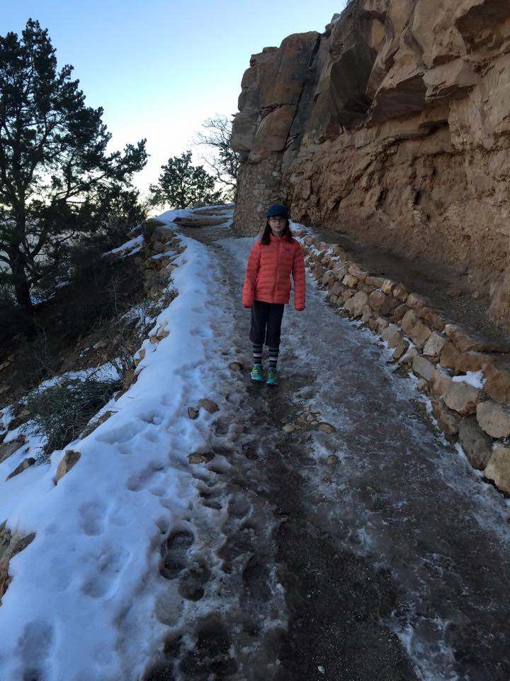
    March often still has snow on the upper portions of the South Kaibab and Bright Angel trails.  Early April would still have some on the North Kaibab.  Microspikes are as much as I would suggest, but my daughter (11 at the time) and I just used trail runners the last time we were there (Grandview Trail in March.  Yes, she’s wearing shorts.  We’re from Alaska):

    South Kaibab in March, one mile in, snow is starting to thin out, we didn’t use any spikes, although Clorox rubbed on your soles will soften/sticky them up:

    BA tends to have more snow in Spring than the SK which gets more sun so check it out the night before.  The BA is definitely easier to hike up (less steep, more (i.e. any) water stops) and the while there is a shuttle bus between the two, it doesn’t run early nor very late and it’s a pretty long hike between them when you *thought* you’d already finished your trip, IME!

    I’ve never had a problem finding parking around the Bright Angel lodge within 1/4 mile of the BA trailhead.  At least not at 4 am when I’m usually starting my hike.

    There are no bears but lots of other critters who’ll try to get into your food.  Either sleep with it all or, if you cache any, use a cookie tin (like those “Danish Cookie Assortments” or the Christmas gift tin of “gourmet” popcorn your sales rep gave you).  Available, empty, at thrift stores for $1:

    I find applying creek water to a bandana or high-absorbancy neck / forehead sponge is less tiring than sweating out the same moisture.  To the point of bringing a pint “dirty water” bottle that I don’t treat, but use to cool myself on during the uphills.

    Check which water sources are on as you descend the BA.  If they’re all on, you only need enough water to get from the River to Indian Gardens (which could be a pint early in the morning if you camel up or 2-3 quarts if it is mid-day in a heat wave – I’ve had 90F in May).  Above Indian Gardens, 3-mile and 1-1/2-mile shelters will (or will not) have water.

    Do you have your permits?  Or a plan to queue up for walk-up permits?  Permits are hard to get for the trail corridor.  One option a UL backpacker might have is to LOOK like a day hiker and stealth camp.  It’s hard to find a place to hide, but once it gets towards evening, you wouldn’t need to be far off the trail.

    Do hills around town to get in condition.  Lots of hills.  Not a stair-climber at the gym – those only go up, and the GC is half going downhill.  If there aren’t hilly trails nearby, then go up and down real stairs in your house or at office building / apartment / hotel in town.  The more I do that prior to a GCNP trip, the better it goes.

    Bring a few pinches of alum if you need to settle sediment out of water prior to UV or chem treatment.  You’re unlikely to need it, but a rainstorm can cause all the creeks to run muddy for a while.  Here’s a write up on it: https://backpackinglight.com/forums/topic/72551/

    I’d go no-cook on a trip like that.

    The grocery store on the South Rim is surprisingly well stocked.  30 brands of micro-brew beer, deli sandwiches, minor first-aid supplies, isobutane canisters, micro spikes, 4-point crampons, a reasonable selection of real, name-brand backpacking stuff at REI-ish prices (not super cheap, but not gouging you).  Call ahead if you are counting on a particular stove fuel – I’ve seen them run out.  Or get it at an REI or Walmart in Flagstaff or Vegas after you fly in.

    When flying into Phoenix or Vegas, I go to Trader Joe’s and get a soft-sided cooler, a bunch of pre-made salads, wraps, and their dried-fruit/nut gorp mixtures.  I eat the salads while on the road and use a wrap or two as my first day’s trail food.

    While I like a Chrome Dome umbrella in the High Sierra in the summer, in the Canyon, I usually use a wide-brimmed hat.  With a chin strap, because winds can come up.  Less important in Spring than in Summer, but coming out of winter, if you don’t have any base tan, be careful.


    #3527707
    Ralph Burgess
    BPL Member

    @ralphbge

    There’s a faucet next to the Admin building (backcountry office) – in the little complex of buildings N of the campground area, map here:

    https://www.nps.gov/grca/learn/news/upload/nr-pocket-map.pdf

    Rim-to-rim-to-rim in two days is very ambitious.   It’s the kind of thing I’d do if I were training for a marathon, not so much if wanted to see the GC for the first time.     What are your aims for this hike?

    You might get permit for Cottonwood campground, it’s not so busy as the others in the corridor until the N Rim opens.   Availability here:

    https://www.nps.gov/grca/planyourvisit/upload/CorAvail.pdf


    #3527717
    David Thomas
    BPL Member

    @davidinkenai

    Locale: North Woods. Far North.

    I didn’t see “two days” before.

    Well, R2R2R in two days is easier than R2R2R in one day (19 hours in my case, but other BPLers do it a lot faster).

    OTOH, You’ve got overnight gear for late-season snow camping on the North Rim and food for 2 days, so that 15-20 pounds of gear will slow you down.  And, guaranteed, you’ll be sorer starting out the second day, than you were the first.

    At least it solves the permitting problem – I assume permits or the North Rim campground aren’t in high demand with the road closed.

    I calc that as 41 “equivalent miles” EACH WAY.  Horizontal miles (21) plus 10 times the vertical (10,000 feet x 10 = 20 miles).  That’s getting into Death March territory unless you’ve already been doing decently high-mileage days (10-15 mile, completely effortless day hikes) this season.  At half my age, I did it in a day, cold-turkey, but the last climb out was grueling and I walked like a zombie for 3 days afterwards.

    One of THE MOST weight-efficient bits of UL gear is a $20 bill.  A 1 gram piece of paper with a slave-owner’s portrait that can be converted to 2 large lemonades, 4 granola bars and 3 Snickers bars at Phantom Ranch store on your way thru each day.  It would be tempting to drop $40 or whatever it is on the beef stew dinner sold to non-guests, but that would constrain your timing far too much.  Keep walking around as you hang out in the store. I find I tighten up, sitting for even 20 minutes on high-mileage trips like that.

    #3527922
    Christopher *
    Spectator

    @cfrey-0

    Locale: US East Coast

    I just did a R2R2R three weeks ago (first week of March.) It has been a light snow year. I did three days with two nights in Cottonwood CG. If you go faster, you are a better man than me. The elevation gains and losses are tough on the quads and toes even for the experienced.

    Cottonwood is a backcountry CG down inside the canyon 6.8 miles from the north rim. It’s a good stopping place if you can squeeze out a third day. It’s a campground but the sites are well dispersed. You don’t get that “people on top of me” feeling. Plenty of water inside the canyon. The climbs on both sides were dry due to pipeline breaks, which apparently is common. As mentioned above the North Rim doesn’t open till May but the North Rim backcountry information office has year-round water … however I couldn’t get to it due to snow. Basically once down water isn’t an issue, but if you are climbing up or down carry extra.

    Good luck.

    #3527938
    David Thomas
    BPL Member

    @davidinkenai

    Locale: North Woods. Far North.

    Did you leave your camp set up at Cottonwood?  Or carry everything with you to the NR?

    #3527941
    Christopher *
    Spectator

    @cfrey-0

    Locale: US East Coast

    Hi David.

    Using Cottonwood as a base camp is the way it should be done by a rational and intelligent person. I am unfortunately not one of those people.

    On a Rangers suggestion I did leave my permit to keep the same site, but after much back-and-forth consideration I broke down camp and brought pretty much everything all the way up and all the way back down. I left a few things in the ammo can. I get too nervous leaving expensive gear behind in the open. The unspoken curse of cuben fiber.

    I guess that kind of redefines pack-your-fears. Haha.

    #3527983
    David Thomas
    BPL Member

    @davidinkenai

    Locale: North Woods. Far North.

    LOL. At some point, a blue tarp would have been lighter (in terms of pound-miles and vertical foot-pounds).

    An ammo can that you brought (cookie / popcorn tins are cheaper and lighter) or does the NPS provide ammo cans at Cottonwood?  (Which would be a fabulous way to avoid animal problems: food brings ravens, rodents, and ants – ants bring scorpions. . . ).

    #3527984
    Christopher *
    Spectator

    @cfrey-0

    Locale: US East Coast

    That would be funny if I paid for a cuben-fiber shelter and then carried it in a big ol’ ammo can to protect it. Haha! Great idea!!!

    NPS puts them at each spot in the campgrounds to deter the ravens and the over-sized ground squirrel monsters.

    #3528018
    Dean F.
    BPL Member

    @acrosome

    Locale: Back in the Front Range

    By “two days” I assume that you mean one night?  I would almost say not to waste your valuable days off on the corridor trails.  Go down Grandview, all the way down to Hance Creek, then camp on Horseshoe Mesa.  You could probably make it down to the river and back.

    #3528062
    Brendan Yeager
    BPL Member

    @byeager

    Locale: New England

    Thanks Everyone!

    The plan is for two full days (David – your a maniac for doing it in one). It seems to me like the rim-to-rim is the perfect intro to the canyon, and this time of year another “to rim” is the only way to get home.

    The miles are ambitious but doable. I don’t go particularly fast, but I tend to put in long days with very little time not spent making forward progress. There will be 13 hours of daylight each day and I plan to spend about 12 of those underway. I will also be travelling pretty light.

    One of my real hopes/goals is to find some isolation on the north rim. Christopher – did you see many people up there? I would be there on a Monday, so I am hoping there will not be more than a handful of people spending the night – but I really don’t know what to expect.

    The next big thing for me to figure out is the permitting. I will give them a call tomorrow, but sometimes it can be tough to actually talk to someone at the parks. Is it pretty safe to assume that walk-up permits will be available? With a whole campground almost inaccessible at the North Rim, I figured there would be space, but now I am getting a little nervous. I have also been faced with rangers skeptical of the miles I was planning before, though they always gave me my permits in the end.

    Looking at the details online, it seems almost certain that I will need to pick up the permit in person. That means either finding a way to get from Boston to the South Rim by 5:00 on Sunday or delaying my start on until at least two hours after sunrise on Monday morning. Ugh.

    Thanks for the tip about the Red Feather – either rolling in late or trying to get a pre-dawn start will be easier out of a hotel room than with a BLM “campsite”. I will have a night to acclimate either way.

    I still need to figure out exactly what I am taking with me on this trip, but it should be under 15 pounds all in. It has been a while since I actually added up my weights, so I think I will try to do so in the next few days and share it here. I am not planning on bringing any traction as it will be mid-April. I have done some “light” glaciers with my trail runners and trekking poles, but if it could be particularly treacherous please warn me off.

    Good to know there will be water on the North Rim. Without needing to dry camp I can cut back on my water carrying capacity.

    I forgot there was a store at the bottom – score. I guess I can cut back on the food a bit. I will probably still bring my stove, as I need my morning coffee and it only adds about 4 ounces with fuel. I expect there to be bear boxes (or UL ammo cans) at the campsite, but if not I could either bring my hang kit or (more likely) stick it in the shelter.

    Another random question – is much of the trail paved?

    Thanks again for the insight – fee free to keep the pointers coming.

    #3528068
    Christopher *
    Spectator

    @cfrey-0

    Locale: US East Coast

    Brendan,

    I only saw about a dozen people between leaving South Kaibab TH until I returned up Bright Angel. At the North Rim TH I only saw one set of snowshoe prints. I felt like I had the park to myself. It was surreal. I was however really early in the season. Despite the time of year I did not require any traction device until I came up over the North Rim. There was light snow at the South Rim and about 2 feet of fluffy new snow at the North Kaibab TH. Temperatures at both Rims were dipping into the single digits at night, but in the canyon where I camped it stayed above freezing.

    The Backcountry permit office responded to my email within 24 hours and I had my permit within 48 hours of initial contact. They were on-point.

    On the subject of timing and mileage, here was my breakdown. I started on Day 1 at South Kaibab around 9:45/10:00am (9:00am hiker shuttle) and I was at Cottonwood by 4:30pm. Day 2 started around 9:00am up to the North Kaibab TH and back again to CWCG around 4:00pm. Day 3 I left CW camp by 7:30, played at Ribbon Falls for over an hour and was up at Bright Angel TH by 4:30. Based on those times a two day run would have been possible at a normal hiking pace with gear, but I was personally ready to be done each day when I stopped.

    Good Luck.

Viewing 12 posts - 1 through 12 (of 12 total)
  • You must be logged in to reply to this topic.
Forum Posting

A Membership is required to post in the forums. Login or become a member to post in the member forums!

Get the Newsletter

Get our free Handbook and Receive our weekly newsletter to see what's new at Backpacking Light!

Gear Research & Discovery Tools


Loading...