later this summer I am planning to do some extended trips. Given the last few years I have some concerns about the possibility of being surprised by fast moving fires. Last I looked Garmin’s weather alerts don’t include fire info. I have memories of someone doing a web service which subscribed to fire alerts which could be in a specific geographic area, and would send messages to an inReach. Alas, I lost the link. Can anyone help me?
Topic
Garmin inReach and Fire Alerts
Become a member to post in the forums.
- This topic has 10 replies, 7 voices, and was last updated 3 years, 9 months ago by
 .
.
Viewing 11 posts - 1 through 11 (of 11 total)
This? http://trailinfo.org
thanks Philip. that is a good backup option. what I remembered was server side… you provide an area and it would send a push notification if anything happened there.
I use trailinfo.org, works great.
As long as you include decimal coordinates in the SMS body, i.e.,
40.44416117100338, -106.81191912717713
you’re in good shape.
If your GPS app doesn’t allow you to determine decimal coordinates, download an app like Decimal Converter, maybe? I haven’t tried trailinfo with anything but decimal coordinates.
I don’t think inReach allows push notifications anymore… (to minimize spam).
I just tested that^ last week and it worked great. I copy/pasted GPS coordinates from Caltopo into the InReach message and got a response right back to my InReach.
By the way, when reporting your location, it’s probably not necessary to go much beyond two decimal places. Two decimal places gives approximately 1 km accuracy. Eight decimal places is a little over a millimeter accuracy. Ryan’s example of 14 decimal places would be a sub-atomic distance.
When getting weather messages through wx2inreach@gmail.com, it automatically truncates your location to the second decimal place no matter what you send it.
G aia has a ‘current fires’ overlay. From their website (with their disclaimer):
Description
An overlay mapping areas affected by currently burning fires throughout the U.S. and Canada. This layer is updated daily as new data is made available by the U.S. National Interagency Fire Center (NIFC), Natural Resources Canada (NRCan), the Province of British Columbia, Alberta Wildfire, and the Government of Saskatchewan. U.S. fires are considered “Extinguished” when no corresponding active fire is present in the U.S. NIFC Active Fires database, and accuracy is subject to data availability. Use this layer to plan reroutes, keep informed of likely trail closures, and stay safe during wildfire season.
Warning
This map source is updated daily as new data is made available by fire agencies, but many fire boundaries will be out of date or incorrect, and recent fires may not have been added yet. Use of this map layer for any purpose is at your own risk, and Trailbehind Inc is not responsible for any actions you take based on the information contained in any map.
Decimal degrees to 2 places is all that is needed to get a weather forecast. For most other purposes, 4 places is adequate and is about the limit of precision of smartphones. Here’s a spreadsheet I worked up for latitudes in my neck of the woods. 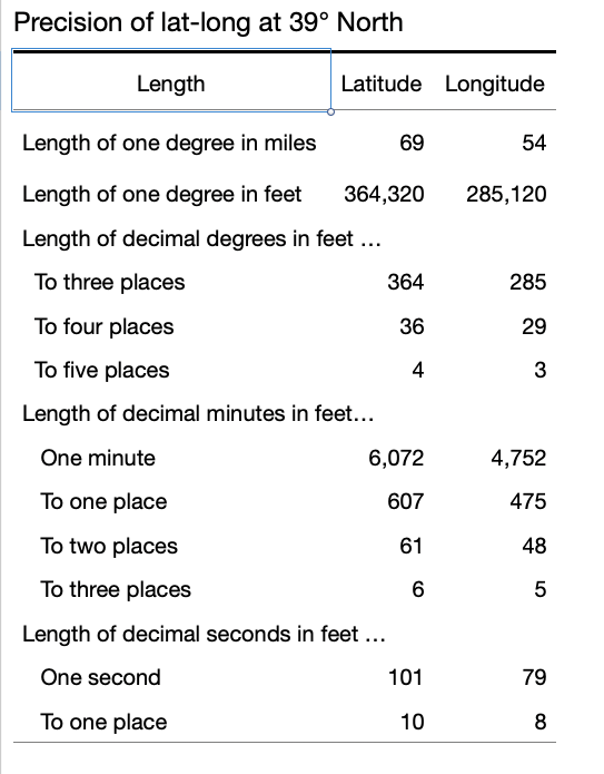
There is a new service in beta which beside fire info does weather, snow depth, etc. I saw the announcement on /r/ultralight, their website is https://awareoutdoors.com
I checked out that Gaia feature in early Sep. It did not show the fires in my area (central Idaho). There were at least 10 of them going at the time (per inciweb). So I’d be leery of it.
Here’s what we have done: Go to inciweb. Look at the contact info for fires that are relevant to your itinerary. Chances are the number is for the fire info officer or general info officer for the national forest where the fire exists. And chances are the number is s cell phone that can receive texts. Call the number and ask the person if you can text them via inreach for updates when you are in the field. My experience is that these folks are awesome and very responsive. (They all say yes) That’s in the forests where I generally recreate (Payette, Salmon Chalis, Nez Perce Clearwater) here in Idaho.
Viewing 11 posts - 1 through 11 (of 11 total)
Become a member to post in the forums.
advertisementYour privacy is protected: We do not transmit your user data to third-party ad platforms or advertisers, and we do not host third-party tracking pixels. Backpacking Light serves ads on its own custom, native, and internal platform.
 New Ultralight ShelterFreestanding silpoly shelter for lightweight adventures.