Topic

GAIA vs SPOT for creating tracks


Forum Posting

A Membership is required to post in the forums. Login or become a member to post in the member forums!

Home Forums Off Piste Other Activities GAIA vs SPOT for creating tracks

Viewing 21 posts - 1 through 21 (of 21 total)
  • Author
    Posts
  • #3463561
    Cameron M
    BPL Member

    @cameronm-aka-backstroke

    Locale: Los Angeles

    I hiked the Sandstone trail today and compared the tracking performance of the SPOT 3 with the GAIA iPhone app. I set the track rate of the SPOT to five minutes. Over a three hour hike the SPOT recorded 54 points, GAIA reported 2524 points. I would be satisfied with the SPOT 3 tracking if it did not drop out for such long periods. I had both devices in my pockets and it is possible that if the SPOT were on top of a pack the results would be different. One can see from the two attached track overlays the relative accuracy of both tracks. The SPOT gets it done, but for really accurate tracking GAIA kills it. I am not convinced that the SPOT upgrade tracking of 2.5 minutes would be enough of an improvement, particularly for the dropout problem. The three hour GAIA tracking rate about 20% of my iPhone charge.

    #3463567
    Bob Moulder
    BPL Member

    @bobmny10562

    Locale: Westchester County, NY

    Obviously SPOT isn’t designed primarily for tracks. :^/

    Probably best for FKTers who want long battery life (~80 hrs with “tracking”) to document their effort but don’t need precise tracks. Yes, it likes a really nice view of the sky. I only turn mine on a couple of times per day to ping my wife (the only reason I carry it!), and for that it can go a couple of YEARS on one set of lithiums.

    I’ve been using Maprika lately on my S5 and it makes very good tracks without eating up the phone battery like Backcountry Navigator did. Can easily get two fairly full days (~10 hours tracking) in airplane mode.


    #3463568
    Matthew / BPL
    Moderator

    @matthewkphx

    It would be interesting to see how the SPOT does mounted on top of your pack.

    #3463569
    Bob Moulder
    BPL Member

    @bobmny10562

    Locale: Westchester County, NY

    Not very well, lol.

    #3463581
    BC Bob
    Spectator

    @bcbob

    Locale: Vancouver Island

    Here’s a comparison of Gaia on my Samsung 7″ tablet and my Garmin Etrex 20 from Saturday.  An area of hills and mostly tree covered.  Gaia is the first one.


    #3463582
    Jerry Adams
    BPL Member

    @retiredjerry

    Locale: Oregon and Washington

    It looks like the SPOT problem is just number of points, not accuracy

    The points the SPOT took matched pretty good the GAIA

    SPOT would be good for letting SAR know where to look for your body : )

    #3463588
    Ralph Burgess
    BPL Member

    @ralphbge

    You probably realize this, but just to state the obvious:  these devices are doing very different things.

    Both are using GPS satellites to triangulate your position.   GAIA is then just recording that information locally on your phone.    But SPOT is uploading your position information via the satellite phone network to the cloud in real time.

    There are a number of reasons why the SPOT device may perform differently.
    (1) The SPOT GPS chip might really be inferior to the GPS chip in your phone.
    (2) The limiting factor might be upload of the data (something GAIA is not even attempting).
    (3) SPOT may be optimized for longer battery life.

    The only one of these I can speak to from personal knowledge is (3).  With the best Lithium batteries, my SPOT Gen3 will operate continuously in 10-minute tracking mode for over 2 weeks.

    The reason that SPOT is the FKT gold standard is because of the real-time data upload.  A GPS track from GAIA (or any other GPS device) is simply a local data file that can easily be faked.   This, of course, is also the reason the a SPOT device can save your life by telling S&R where you are, whereas your GAIA file will just tell the recovery team the route that you took if they eventually find your body (and your phone)!


    #3463598
    Cameron M
    BPL Member

    @cameronm-aka-backstroke

    Locale: Los Angeles

    I think it is the upload problem, as well as battery optimization, and it is accurate enough. I doubt if the SPOT had been in the top of my pack that it would have made a difference. I have noticed the dropouts before in many different situations. In terms of letting people know where you are/getting help, the SPOT is more than fine, but the tracks it creates are somewhat crude.

    #3463611
    Greg Mihalik
    Spectator

    @greg23

    Locale: Colorado

    “I set the track rate of the SPOT to five minutes. Over a three hour hike the SPOT recorded 54 points…”


    Something doesn’t add up –

    At 5 minute intervals you should get 12 points an hour, for a total of 36 points over the 3 hours.

    What am I missing?

    #3463626
    Jake J
    BPL Member

    @psykokid

    Locale: Socal

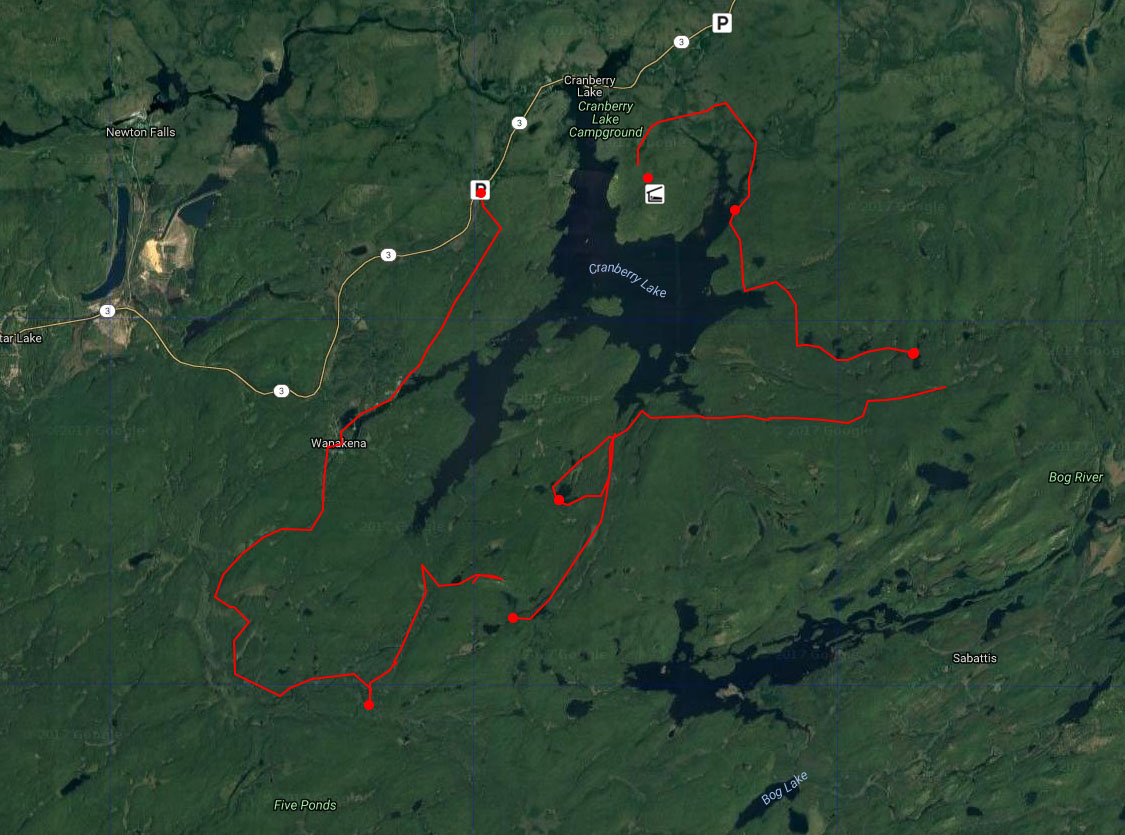
    I hike with my Spot lashed to the top of my pack and it normally does pretty good at recording points. If you go into a deep canyon or heavily shaded area though, it’s a crap shoot.

    Here’s a caltopo link to a 22 mile hike I did the weekend before last:

    https://caltopo.com/m/QTHT

    The blue track was from my Suunto Ambit 3 Peak. The Spot “track” is in red. My Spot is set to ping every 10 minutes. If you look at the track there are a few big gaps between a some of those pings. In the area of the biggest gap it’s pretty covered over and a half of the time is at the bottom of a canyon. Same situation for the second bigger gap. For the last big gap, who knows. the track was on a ridgeline with little to no cover..

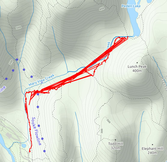
    For good out in the open terrain with minimal tree coverage the Spot normally does really well. Here’s another loop on Caltopo where the majority of the track is open with little cover:

    https://caltopo.com/m/ECJE

    The tracking on the Spot was set to ping every 5 min on this trip. It pinged well on this one, but it’s basically just a collection of points not a real GPS track like the Garmin e-trex recorded.

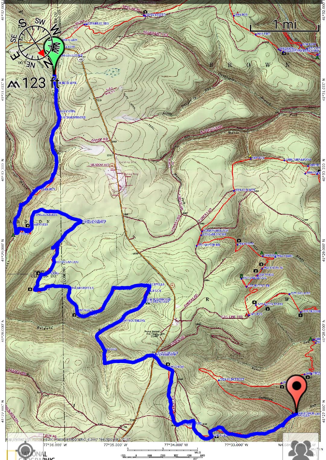
    For recording tracks I either use my Suunto or a Garmin e-trex 20. I used to use Backcountry Navigator on my phone but I found it just sucked down too much battery life. The Spot is useful for family and friends to check up on where you are and for emergency SOS if SHTF. It’s not designed to create detailed tracks.

    I picked up a second hand Inreach Explorer and I will compare that with the Spot as far as accuracy once it comes and I get it activated. I expect the same, but with the Inreach it will be nice to get a conformation of if the ping got picked up or not. With the Spot you dont know till you get home and check the points online.

    #3463631
    Greg Mihalik
    Spectator

    @greg23

    Locale: Colorado

    “[SPOT is] not designed to create detailed tracks. ”

    Please elaborate. SPOT sends locations and they are plotted, similar to the inReach, on intervals as short as 2 minutes.


    “…but with the Inreach it will be nice to get a conformation of if the ping got picked up or not.”

    The “Tracking” screen shows when the “last location” was sent.

    Where do you find the “acknowledgement” that it was received?

    #3463660
    Kenneth Keating
    Spectator

    @kkkeating

    Locale: Sacramento, Calif

    The Inreach doesn’t ping when it uploads your automatic tracking locations.  It pings when your send a message and it confirms the message has been sent.  It’ll also ping when you send you location to someone and the message has been sent.


    #3463695
    Cameron M
    BPL Member

    @cameronm-aka-backstroke

    Locale: Los Angeles

    “At 5 minute intervals you should get 12 points an hour, for a total of 36 points over the 3 hours.”

    OK, I figured that one out. The way Google Earth imports, with the settings I had, it imported 2 tracks with 54 points. So really the SPOT track has only 26 points, well short of the 36 points to be expected. Same mistake with the GAIA, it has “only” 1,262 points- that’s seven points a minute!

    #3463719
    ben .
    BPL Member

    @frozenintime

    out of curiosity, can you change the rate at which gaia drops points?

    #3463842
    Kenneth Keating
    Spectator

    @kkkeating

    Locale: Sacramento, Calif

    One of the issues with accuracy is it’s hard to determine because the tracks can vary.  There’s one 2-mile trail where I have about  Gaia10 tracks recorded over the past two years, and each track is different.  In other words, accuracy may be very close on one trek, then off on the next one.  Part of the the issue may be due to position of the satellites and signal strength during a particular track.  I’ve notice the same with my Inreach Explore on the PCT. Some points will be off over 300 feet from the trail.

    Does anyone know if Gaia tracks off of satellite or towers if cell service is available? I just went on a 600 mile trip road trip in Calif and tracked it with Gaia and it was very accurate, down to the correct side of the freeway.

    #3463884
    Cameron M
    BPL Member

    @cameronm-aka-backstroke

    Locale: Los Angeles

    Ben: you can upgrade to allow 2.5 minute tracks, but it is still the same problem: if you get a drop-out for 45 minutes, your recorded track will be ugly.

    Ken: I have noticed the same tracking “offset”; on some hikes the GPS location is persistently off in one direction by about the same distance. Must be the iPhone hardware and satellite locations.

    #3463914
    Bob Moulder
    BPL Member

    @bobmny10562

    Locale: Westchester County, NY

    If a really good track is of paramount importance I relent and use my Garmin eTrex 30.

    However, a really good track is rarely needed so that’s 5.3 oz that doesn’t get carried, which offsets the 4.3 oz penalty for the Spot. And if I change my mind I can get a very decent track with Maprika.

    #3464025
    Cameron M
    BPL Member

    @cameronm-aka-backstroke

    Locale: Los Angeles

    In terms of weight penalty, I carry the SPOT when I think I will be completely alone in deep backcountry for longer than a day. So the tracks from the SPOT are “free”, unless I go for too many days, then requiring more battery. I use up 20% of the iPhone battery per day without tracking, and 55% when using GAIA tracks, so I reckon that tracking on the iPhone costs me .25 charges a day. Over a typical ten day trip, that’s 2.5 charges, which amounts to about 4 oz of usb battery weight.

    I am sure that someone has done the work of figuring how many hours the SPOT gets in 2.5, 5 minute and 10 minute tracking modes using lithium batteries- let me know!

    #3464058
    Kenneth Keating
    Spectator

    @kkkeating

    Locale: Sacramento, Calif

    On an Inreach, battery life is very dependent on satellite available and line of site.  I’ve been in deep forested canyons and used a lot more battery life with 20 minute tracking  as opposed to hiking in an open valley with 20 second tracking in the same amount of time.

    #3464122
    Ralph Burgess
    BPL Member

    @ralphbge

    As I said above, I run my SPOT Gen 3 in 10-minute tracking mode, and new Lithium Ultimate batteries last at least 2 weeks (I have never run new batteries all the way down to find out just how long).   Given that battery life, I think it’s sensible to just leave it running the whole time.   A GPS fix needs line of sight to 3 satellites, but data upload (including SOS) requires just one.   If you do have to hit the SOS button, you may be in a place where you can send the SOS but you can’t get a good position fix.   But if you’ve been continuously tracking, S&R should have a recent position and direction of movement to narrow down where you are.

    #3464131
    Cameron M
    BPL Member

    @cameronm-aka-backstroke

    Locale: Los Angeles

    Ralph: I have been in the habit of turning off the SPOT when I stop, and I see now that perhaps that may not be all that helpful. However I think a definitive test would be recording only the hours during which there is actual movement, as they claim that the vibration sensor economizes battery life. There might still be some variation for apparently, like the InReach, it tries harder when not getting a clear view of the sky, but I imagine that a decent average could be found. SPOT provides a simple diagram that is not so informative:

    and there is another confusing spreadsheet, except it clearly suggests that in continuous tracking mode you may only expect 4.5 days:

    (above found here): http://www.findmespot.com/en/index.php?cid=1700&action=showEntry&data=1330

    I have not found much online where anyone went about this methodically. But another consideration is that although the batteries may still be functioning, low battery power may mean less ability to send SOS.

Viewing 21 posts - 1 through 21 (of 21 total)
  • You must be logged in to reply to this topic.
Forum Posting

A Membership is required to post in the forums. Login or become a member to post in the member forums!

Get the Newsletter

Get our free Handbook and Receive our weekly newsletter to see what's new at Backpacking Light!

Gear Research & Discovery Tools


Loading...