Topic

Do I need this gear for Glacier Nat'l Park?

Viewing 25 posts - 1 through 25 (of 26 total)
PostedMar 16, 2016 at 6:40 pm

Hi! I have a good bit of experience backpacking, but have never been to Glacier. I will be going at the end of August, and will be doing a short backpacking trip (4 days and 3 nights) with a couple other gals. Yay!

Unless the forecast looks abnormally cold right before we leave, I will be wearing a short sleeve wool shirt and quick-dry pants or shorts. In my pack, I will have a wool or capilene long sleeve baselayer top and bottom, a lightweight synthetic insulated jacket, and a rain jacket.

My question is, should I bring a midlayer (such as a lightweight fleece) in addition to all that? I figure 2 out of the 3 nights, we’ll be hanging out around camp for a while before going to sleep. I currently do not have a lightweight packable midlayer because I have been taking way more rock climbing trips (car camping) than backpacking trips for the past few years. So my midlayers now are a little on the heavy side (Patagonia Better Sweater and the like), and being on a tight budget, I would rather not spend the money on a midlayer unless I have to. Plus I’d rather not carry one if I don’t need it. So if anyone has been there in late August/early September (I know conditions and weather can vary greatly) and can tell me what you brought, or what you would bring next time, that’d be great :)

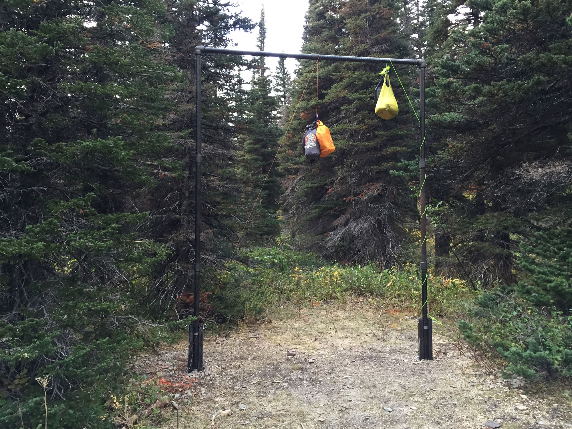
My other question is whether y’all recommend a bear canister, or if I can get away with hanging my food (which I do not have much experience with, as most places I’ve backpacked are at/above timberline and require bear canisters).

Thanks in advance!

-Katie

Brad Rogers BPL Member
PostedMar 16, 2016 at 7:05 pm

Check the NP website but I dont think canisters are allowed as you must stay in designated sites with poles to hang on.

As for a midlayer, it can be a personal thing, but if you decide to bring one, Lands End has 100wt fleece pullovers for under $20 and they use Polartec feece (my Mens M is 8.8oz)


PostedMar 16, 2016 at 8:31 pm

I cannot tell you which clothing to take but I can supply some temperatures recorded with a min/max thermometer. Temperatures are inside the tent.

August 18, 2012, Poia Lake 43 degrees F.
August 19, 2012, Head of Elizabeth Lake 44 degrees.
September 11, 2015, Lincoln Lake 43 degrees.

Can’t find all my notes now or I would add to the list. I am sure the coldest end of August overnight temp I have experienced was on Flattop Mtn. about 5 years ago–28 degrees.

The coldest I have ever “felt” at the end of August in GNP was offtrail on the ridge near Bishop’s Cap (Logan Pass area) while on a dayhike about 7 years ago. While not moving I was wearing everything I had–down sweater, gloves, cap. It was very windy and foggy. As soon as we dropped down ~500 feet it was much warmer. I have no idea of the actual temperature, perhaps in the 30’s.

A bear canister is dead weight in GNP; it would have to be hung just like the food bag :(. Hanging your food bag is easy on the man-made crossbars. 35 feet or so of cord can be safer (more tie-off points) than the GNP-recommended 25 feet.

Interesting side note: early last year I was in the backcountry permit office and noticed about a half dozen Ursacks! They mentioned that the Ursacks had recently been approved. Presumably they would also need to be hung just like any other food bag. Not sure if they were “loaners” or for ranger use.

PostedMar 16, 2016 at 9:57 pm

I will make one clothing recommendation. Bring rain pants even if the weather forecast is favorable. The lush vegetation on some trails is so dense that it drapes over the trail tread to such an extent that it is not possible to see your feet (Yeah, I’m thinking of you, Stony Indian Lake area!). It is not unusual for the vegetation to accumulate morning dew or rain which then transfers to your clothing. This can be either a refreshing experience or it could make you miserable.

You could always ask the rangers about trail conditions when you pick up your permit; most trails are clear and unobstructed; rain pants might not be necessary.

I remember a BPL thread about one year ago in which others talked about this issue.

Edited: to clarify extent of the problem. Original wording may have exaggerated the issue.

PostedMar 16, 2016 at 10:26 pm

Great info, thanks to both of you!

I very rarely wear rain pants, so I’m glad you said something. We’ll definitely check with the rangers.

So in Glacier, it is mandatory to hang your food, et al, in the backcountry? I can’t seem to find anything about that one way or the other on their website, other than they have poles at most backcountry campsites.

PostedMar 16, 2016 at 10:31 pm

In my brief experience, you must stay in a designated campsite, which will have one of three ways to deal with food: bear locker, center pole hang, or cross bar hang. So at least bring a bit of cord and a bag suitable for hanging. I made the mistake of closing a bear locker WITH a mouse inside. By morning he had managed to put a hole in virtually every food item, and emerged looking like a balloon!

PostedMar 16, 2016 at 11:10 pm

The only lockers I have seen are at Fifty Mtn. and Elizabeth Lake foot; there are probably others but they seem to be rare compared to the hanging apparatus.

Here is the wording on the permit: “When arriving at your campground, you must FIRST GO TO the FOOD STORAGE DEVICE and hang all bear attractants in a DURABLE STUFF SACK with a ROPE a minimum of 10FT UP off the ground and 4FT OUT from all trees.”

Capitalized words are as presented on the permit.

It further goes on to say (paraphrasing) you must hang food, stoves, fuels, pots, cookware, water bottles, toiletries, garbage, food-scented clothing. Bear attractants must never enter any tent area. Uh-oh, I usually have a virgin (never exposed to Gatorade, etc.) water bottle in my tent–please don’t tell anyone.

PostedMar 16, 2016 at 11:30 pm

I was there early August in 2014 and just wore a short sleeve shirt and shorts, except for a couple hours on a cloudy, windy day going over Gunsight Pass, where I threw on a light fleece. I had a light puffy (Marmot Quasar) but never needed it. I’ll be there this August as well and plan to carry the same stuff minus the fleece, unless the weather is forecasted to be super cold (short sleeve shirt, shorts, Patagonia Cap2 bottoms, Quasar, and Driducks jacket).

I agree with the others about the bear can, it’s not needed, just make sure you have cord / bag for hanging.

David Chenault BPL Member
PostedMar 17, 2016 at 9:36 am

Clothing sounds good.  John has good advice about rain pants.

Designated sites will have a food pole or wire for hanging.  The few which have lockers have them either because avalanches kept knocking down the food pole (Stoney Indian) or flying squirrels made hanging food untenable (Liz Lake).

The Ursaks are loaners for use by folks camping at undesignated sites in the alpine, typically while mountaineering.

Gary Dunckel BPL Member
PostedMar 17, 2016 at 9:51 am

So, Dave, why do you suppose that there is a food locker at Upper Two Medicine Lake? Maybe they had an extra one and didn’t know where else to put it?

David Chenault BPL Member
PostedMar 17, 2016 at 10:54 am

At some point in the next ~50 years Upper Two Med will get avalanched, just like the Gunsight Lake camp did in 2011-12.  The reason is more likely that it’s easy to transport a locker most of the way using the boat across the lower lake, and lockers are preferable to poles or wires because they can be moved around and/or placed in areas where soil and root compaction don’t impact trees.

Gary Dunckel BPL Member
PostedMar 17, 2016 at 11:33 am

Yeah, the boat helps with the transport of the heavy locker to UTM. It must have been a chore to get them to Liz L. and Stoney Indian. I suppose they could have used pack horses in the Belly R. area, or are they not allowed beyond the Gable Creek RS cabin?

The disadvantage of lockers is that they make great garbage cans. The one that I saw in YNP’s Slough Creek had, of all things, some shards of a big broken China bowl. And also a couple of gallon Ziplocs with messy trash. I concluded that Slough’s fishermen are red-neck pigs…

RMNP in Colorado removed their ammo cans and instituted the bear canister rule for the same reason–too much garbage being left in the ammo cans.

PostedMar 17, 2016 at 8:04 pm

Again – great info y’all! Thanks a million.

For reference, this is the itinerary I hope to get a permit for. I chose this based on skill levels (there will be some FIRST time backpackers with me! Which I am so excited about. As well as spectacular views (based on internet research and word of mouth):
•Day 1 – Mile 0.0 – Mile 7.6: Logan Pass Visitor Center (where the vehicles will be parked) to Granite Park Campground 7.6 miles
•Day 2 – Mile 7.6 to Mile 19.5: Granite Park Campground to 50 Mountain Campground (take the Sue Lake spur!) 11.9 miles (+.8 miles for Sue Lake)
•Day 3 – Mile 19.5 to Mile 27.2: 50 Mtn to Kootenai Lakes 7.7 miles
•Day 4 – Mile 27.2 to Mile 30: Kootenai Lakes to Goat Haunt Ranger Station 2.8 miles (then ferry & shuttle back to car at Logan Pass)

PostedMar 18, 2016 at 7:06 am

You should not experience any overhanging brush on days one and four. Kootenai Lakes to the turnoff to Stoney Indian is clear walking. I have no knowledge of the remainder.

I thought that talking to customs when entering Canada at the end of the boat ride was unusual. There will be someone at the dock who will hand you a cell phone; you will answer a few questions then be on your way! 99% of the boat riders do not cross the border.

Gary Dunckel BPL Member
PostedMar 18, 2016 at 7:54 am

“99% of the boat riders do not cross the border.”

I don’t get that, John. Everyone that takes the boat from Goat Haunt to Waterton  crosses the border. I assume that Katie will take a bus from Waterton, back across the border at the Chief Mtn. customs, then on to where, the Swiftcurrent Lodge or maybe the St. Mary visitor center? I’m not sure of the logistics of switching from the Waterton bus to the Park’s shuttle.

(edit) Maybe the bus from Waterton stops at customs and the passengers switch to a Park shuttle bus at that point?

At any rate, Katie, if you intend to park at Logan Pass, be sure to get there early. That parking lot fills up well before noon, and it stays full all day. Another option is to park at either the Rising Sun Lodge, the Swiftcurrent Lodge, or the St. Mary visitor center (probably the best place), and take the shuttle west up to Logan Pass. The way to do this is to stay at the Babb Motel the night before, bulk up on a big breakfast at their cafe across the highway, and then drive to St. Mary to park and catch the shuttle bus to Logan Pass. This positions your car for easy retrieval after the shuttle from Waterton.

Also, if you have a few more days to spend, consider hanging out in the Many Glacier area and doing one or two splendid day hikes in that area (Grinell Glacier, Iceberg Lake/Ptarmigan Tunnel, Swiftcurrent Pass trail, or Cracker Lake). The Babb Motel is the cheapest lodging, but the Swiftcurrent Lodge is better located. If nothing else, be sure to sit on the knoll between the iconic Many Glacier Hotel and its parking lot up above and watch the sunset over three splendid valleys–I think it’s the best view in Glacier.

PostedMar 18, 2016 at 7:55 am

Hi Dave

Thanks for explaining why there are bear lockers in only some places.

Do you know why at Elizabeth Lake they have the jungle gym pole, with no instruction about lines? It seems that a bear can snag the tied-off line easily; at least it is the received knowledge in the Sierra that the line is vulnerable.

PostedMar 18, 2016 at 8:17 am

Gary, I am on my way out the door, not much time. It is my impression that most people start and end the boat ride from Waterton. They walk along the shore at Goat Hant, then return, just doing the tourist thing for a few hours.

Gary Dunckel BPL Member
PostedMar 18, 2016 at 8:43 am

I see what you mean now, John. Yep, day trippers. But for someone doing a one-way boat ride like Katie will do, customs then enters into it, passports are required, etc. It might be possible for Katie and friends to get that handled right at the Goat Haunt R.S. while waiting for the boat.

David Chenault BPL Member
PostedMar 18, 2016 at 11:09 am

Good itinerary, should be fun for all, and doable for all.  Day 2 will be the physically toughest, but the scenery will distract well.  50 Mtn in top five of all backcountry camps in the park.  Once you drop down into the Waterton valley you’ll have a few miles of 4 foot tall brush.  Fun stuff.

Thankfully Grizzlies in Glacier and the Bob have never been conditioned to anywhere near the extent of bears in the Sierra.  It’s something of a secret, but when Yellowstone shut down their garbage dumps the NPS had to kill a significant percentage of the bears in the park, which was presumably the only way they avoided a Cali-style intergenerational habituation problem.  For obvious reasons the NPS in Glacier is very proactive about bear issues.

Most folks who take the boat over from Waterton to Goat Haunt don’t go beyond the beach.  Though they are in the US, as a convenience/courtesy they do not have to clear customs.  If they want to dayhike beyond the beach, either south towards K Lakes or back to Waterton town, they need to present passports to the US border patrol.  Crossing into Canada via the boat is mellow and simple compared to the reverse.  You’d think the USBP agents with such a scenic posting would be less dour than their colleagues on the roads, but that has never been my experience.

I’ve never encountered garbage in the Glacier food lockers, but did find 15 pounds of poptarts and canned tuna hanging from the pole at Browns Pass a few years ago.  The rangers and trail crew at Goat Haunt appreciated the donation.

PostedMar 18, 2016 at 12:31 pm

Wow sorry about the weird formatting in my last post! Oops.

Gary, GREAT info! I appreciate you so much. Yes, the plan is to ride the ferry from Goat Haunt to Waterton. There’s then a paid shuttle that we’ll take from Waterton to St Mary. Luckily all of us already have passports. If we were to leave the car at Logan, we’d then take the Glacier NPS free shuttles from St Mary to Logan. However, from the info y’all have given me, I think leaving our vehicles at St Mary is a much better idea :)

And yep we have 2 extra days in the park for dayhiking. Thank you for the suggestions! Lake McDonald also looks worth seeing.

My other question is, for the trails/campsites in my itinerary, how many streams/lakes (ie, chances to fill up on water) will there be? I don’t want to carry 3L of water at a time if I don’t have to. I’ll be bringing a Katadyn pump filter; in the past I’ve always backpacked in areas where I can stop several times a day and filter more water as needed. However from the maps I can’t quite tell if there will be small streams and stuff to fill up at each day. Basically, I don’t want to carry a bunch of extra weight, nor do I want to run out of water! haha.

PostedMar 18, 2016 at 3:10 pm

David, thanks for clarifying the border situation. Yes, technically the boat ride takes you from Canada to the U.S. or vice versa but the U.S. customs folks are about a 10 minute walk from the boat dock and they are not checking everyone who gets off the boat; as far as I can tell they only talk to people who go past their HQ. I was using the words border and customs interchangeably; sorry for any confusion. That’s what I do best :).

Gary Dunckel BPL Member
PostedMar 18, 2016 at 4:14 pm

John or Dave, could you respond to Katie about the availability of water along the Highline Trail? I haven’t hiked that stretch, but the map shows just a couple of obvious creeks along the way from Granite Park to 50 Mtn–Ahern and Cattle Queen, which are pretty close together. It looks better north of the 50 Mtn campsite.

Katie, one thing about Kootenai Lake(s)–lots of moose live there, mostly females with their babies. 10 years ago I went there to specifically hang with them for a night. I chose the campsite farthest from the food prep area, which gave me the privacy I usually seek, and also the perfect view of the lake and moose. It was a fun wildlife show, for sure–so many moose in one place (10 or 15). But don’t be fooled by their apparent mellow attitude. Moose are very unpredictable ( a gal from MN probably knows this), and they can become agitated and dangerous when they feel that their space is infringed upon. Watch them from a distance. I received my trail name “Mooseman” back at Goat Haunt because of a dangerous encounter with a momma moose that I thought was going to kill me at my Kootenai L. campsite. She figured that I was somehow her biggest problem, and she got right in my face, grunting and spitting and digging the ground furiously with her front hooves. She eventually calmed down and bolted from the campsite as fast as she came. I learned a few moose-words that day.

If you want to add a decent layer of protection, set up your tents at a site away from the lake, and just walk the short trail to check out the moose. You’ll probably be able to hear them grazing along the north shore throughout the night, no matter which campsite you pick.


PostedMar 18, 2016 at 7:51 pm

Katie and Gary,
I have not walked the middle ~2/3 of the route; David probably has much better water source info.
There are several good places to obtain water during the first 2 to 3 miles when it is least likely to be needed. It has been quite a few years since I walked from the Chalet to Haystack Butte. I do remember a good small stream just before the Chalet. Much farther along there is an excellent stream at Fifty Mtn. camp.
Last summer I did some day hikes during the hot season. It was easy to consume 3 quarts per day but I only carried about 2. I filtered some. Hate carrying more than 1 1/2 :).
If one of your group has a small pair of binoculars you could put them to good use looking for mountain goats on the Garden Wall south of Haystack Butte. Also useful for looking at moose at Kootenai Lake. And bears at Fifty Mtn.
Secret hint: look for whortleberries as you are climbing up toward Haystack Butte. Look them up if you don’t know what they are. Maybe a little late in the season but there could be a few left worth picking and eating. Take it easy on the picking; it is my understanding that everything in Nat’l. Parks should be left there.
Happy Hiking!

David Chenault BPL Member
PostedMar 19, 2016 at 8:11 am

Lots of water along the Highline, a bit less frequent during very dry/hot years like last.  At mininum on the second day you’ll get good water in both Ahern and Cattle Queen Creeks, and most likely the side creeks going into Ahern, and the final drainage before the 50 Mtn Meadow (Mineral Creek).

PostedMar 19, 2016 at 2:55 pm

Thanks so much for the help guys. I remember this forum being a wealth of information back when I was getting ready for the JMT in 2011! I actually got a little TOO confident and tried my hand at making my own dehydrated meals for the trail…what a disaster :p I tend to learn everything the hard way.

Gary, that’s a great story! I’m glad it had a happy ending, haha. I’m actually originally from Louisiana and have been living in MN for almost 4 years, and still haven’t seen a moose in person, so I’m REALLY excited to hear we will most likely be able to see some! From a distance, hopefully :) I have had experience with backpacking around bison (in TX, OK and MN), which can be just as temperamental. Closest we got to one is when 3-4 wandered into our campsite at the Wichita Wildlife Refuge (while we were sleeping) and woke us up with their weird grunting/sneezing sounds :)


Viewing 25 posts - 1 through 25 (of 26 total)
Loading...