Topic

Desolation Wilderness Questions


Forum Posting

A Membership is required to post in the forums. Login or become a member to post in the member forums!

Home Forums Campfire Trip Planning Desolation Wilderness Questions

Viewing 11 posts - 1 through 11 (of 11 total)
  • Author
    Posts
  • #3605162
    Jesse P
    Spectator

    @jessep

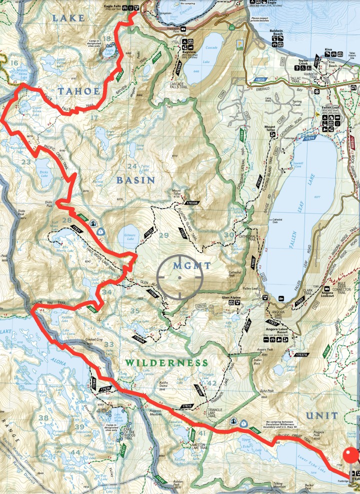
    Taking my first hike in the Sierras (and first hike out West!) mid-September and have a few general questions for this awesome community. Going on a 3-day out & back from Echo Lake to Emerald Bay. I would love to cover much more ground but this was all I could squeeze between other engagements.

    Here goes!

    • What would you guys suggest I bring for food storage? Bear can or opsac+hang kit?

    • How common is bear activity in the area?

    • What is the bug situation this time of year?

    • Any idea what the conditions might be mid-September?

    Trying to figure out what I should pack clothing wise, as well. All of my experience is in the Mid-Atlantic East and for most nights above freezing I carry Capilene lightweight top and bottoms, grid hoodie, liner gloves and beanie. Below that I toss in an insulated jacket and wool sleeping socks. Is this system adequate for the Sierras? My sleep setup is a Katabatic Flex 22, full size NeoAir, and fully enclosed shelter.

    As far as worn clothing, I prefer running shorts and can usually get away with them well into October in my region but would that still be a viable option here or should I just pack full length pants?

    Thank you ahead of time for any and all information. Thoughts or opinions on the proposed area also welcome!


    #3605179
    jscott
    BPL Member

    @book

    Locale: Northern California

    Hi: could you expand a bit on your itinerary? I’m guessing, Echo Lake to Aloha lake and then possibly over Dick’s pass and then down to the Emerald Bay –Bayview–trailhead and then…back? (You wrote ‘out and back”.)

    –bugs are usually not an issue in Sept.but this is an extraordinary year so who knows

    –bears have never been an issue for me here. I’ve hung food but honestly, once I got a bearikade scout I carried that for any three day hike in bear country (because there are definitely habituated bears here–it’s just, Desolation is a wilderness area that allows hunting, and that helps.) That said, there are no good hangs around Aloha that I can recall, or Dicks lakes or Velma lakes really.

    –even in this heavy snow winter, I can’t imagine that snow will be an issue in Sept. Nights will be cold. And of course, there’s always the possibility of a storm of some sorts at that time of year–but usually weather holds off until the end of October so you should be fine in that regard.

    #3605180
    Five Star
    BPL Member

    @mammoman

    Locale: NE AL

    I’ve seen recent reports about a very wily bear in the DW.  I would be bringing a bear can.

    #3605183
    jscott
    BPL Member

    @book

    Locale: Northern California

    That wouldn’t surprise me at all, Five Star.

    #3605251
    Alex Wallace
    BPL Member

    @feetfirst

    Locale: Sierra Nevada North

    I’d take the bear can. I actually just talked to a ranger last week and she mentioned that there have been a few incidences near Middle Velma lakes recently. Regardless, the trees out there aren’t really conducive to a proper hang. I’ve seen a bear in Desolation twice and both times it hurried off per the hiker/bear agreement.

    Your sleep setup is more than adequate. Clothing sounds good too and shorts during the day should be fine. By mid September temps can dip below freezing at night and day time highs are usually high 60s to low 70s. Of course, check the weekly forecast before your trip and adjust your layers accordingly.

    Mosquitoes shouldn’t be a problem. Maybe a few at dawn and dusk, but you have a fully enclosed shelter so it should’t be a big deal.

    Do you have a specific route picked out?

    #3605299
    Jesse P
    Spectator

    @jessep

    Thank you guys! I really appreciate the feedback.

    I am starting at Echo Lake Chalet. My permit for the first night is Dick’s Peak Area. After that the plan is to stay on the PCT until Eagle Falls Trail, following that all the way out, then back to the car. About 40 miles.

    I’m open to any suggestions as I don’t know the area at all and have planned this based on maps only.

    #3605367
    jscott
    BPL Member

    @book

    Locale: Northern California

    I personally find the trail from the Eagle Falls/Bayview split down to Bayview trailhead to have far better views. the Eagle Falls trail is mostly enclosed in forest and down in a canyon. Bayview offers great views of the lake–probably the best views on that hike, plus a nice little lake whose name I forget en route. Better forest too.


    #3605374
    Kenneth Keating
    BPL Member

    @kkkeating

    Locale: Sacramento, Calif

    It’ll be a beautiful hike.   I did the PCT through this area last year. My recommendations are as follows:

    1. 1st Day: Hike to Gilmore Lake, set up camp, then hike up to Mt. Tallac(NW of Gilmore Lake) and back.  Beautiful views of Lake Tahoe if the skies are clear. If a forest fire is happening in Calif, depending on the location and winds, the visibility could be greatly reduced.When you arrive at Gilmore Lake, turn left(west), plenty of campsites about 1/3 mile away.

    2.  You can cut three miles off of the trip if you take the boat taxi from the the marina to Upper Echo Lake.  It’s a fun boat ride, beautiful trip.

    3. Bring the bear canister.  I’ve had issues with rodents getting into my backpack in Desolation Wilderness and ever since I’ve brought the canister along.

    4.  If you don’t have someone to drop you off at the starting point, drop off your vehicle at Eagle Falls Trail Head and take an Uber to Echo Lakes.  Plenty of Ubers in the area.  But check your cell phone coverage before you go to the trail head.  You may not get coverage at the trail head, so you may need to meet the driver at a location where you do receive coverage.

    5.  Snow won’t be an issue.

    6.  Check the weather forecast before you go, and use the spot specific location function on the NWS forecast site.  It could be hot or cold, mid-Sept conditions can vary.

    You’ll have a fun trip!

    #3605376
    Kenneth Keating
    BPL Member

    @kkkeating

    Locale: Sacramento, Calif

    NM

    #3605415
    Alex Wallace
    BPL Member

    @feetfirst

    Locale: Sierra Nevada North

    I agree with Jeffrey that the Bayview trail has better views than Eagle Falls. Plus, you can summit (walk up) Maggie’s Peaks. According to legend, in the 1800’s Maggie was a well endowed barmaid at the Tahoe Tavern. Wonderful views from the top.

    Parking is limited at Bayview TH (at the back of Bayview Campground) and usually full by mid morning. There’s room on the highway adjacent to the campgrounds at the pullout. I’ve left a vehicle there for up to a week with no problems.


    #3605419
    jscott
    BPL Member

    @book

    Locale: Northern California

    I’m away from a map, but…you could do a route that takes you over a tiny pass (bump) at Aloha and then, if I remember right, has the option of reconnecting up around Velma lakes. (I may be misremembering.)It runs on the west side of the ridge that borders Dicks lake. It would allow you to not do an entire out and back. and it would be less populated with hikers, if you care about that.

    That said I’ve never done that route so I don’t know how scenic it is.

Viewing 11 posts - 1 through 11 (of 11 total)
  • You must be logged in to reply to this topic.
Forum Posting

A Membership is required to post in the forums. Login or become a member to post in the member forums!

Get the Newsletter

Get our free Handbook and Receive our weekly newsletter to see what's new at Backpacking Light!

Gear Research & Discovery Tools


Loading...