


see next post, as this post doesn’t allow editing
Topic
Become a member to post in the forums.
 .
.
see next post, as this post doesn’t allow editing
How do I interpret the Course reading on the Location screen?
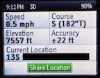
How should I hold the SE?
Any tips or tricks appreciated.
Edit: or is it my trending from my prior track points?

I’ve been using the Explorer for just over two years and have found the GPS/location feature to be accurate and reliable. The compass is a different story however, even after calibrating it multiple times. The one best way I’ve found to get a bearing is to hold the unit in front of you and start walking, standing still is a total crapshoot from my experience. Even so, with checking my bearing with a good magnetic compass, the Inreach compass was usually 12*-15* off with declination accounted for. The manual is lacking for information and after calling Delorme (back then) for little help, I finally gave up and don’t bother with it and instead carry a magnetic compass. Hopefully Garmin has updated this feature to fix it and someone can chime in with new info.
Have to agree with Terry, it’s a great gps communicator but the compass is about as accurate as the one in my Jeep! I definitely wouldn’t recommend using it to navigate.
My impression is that it’s the direction between the last two marked gps points as it is more accurate on long straight sections and wildly inaccurate on twisty trails.
Become a member to post in the forums.
 Vaer C4 Tactical Field SolarDurable timepiece for wilderness users - 20ATM (200m) water resistance, 120-click bezel, 316L SS casing, sapphire glass, solar-powered, Epson VS-42 Japanese movement, C3 Lume, USA assembly.
 © Beartooth Media Group Inc.
 Loading...