Topic

Current Conditions for Humphreys Basin


Forum Posting

A Membership is required to post in the forums. Login or become a member to post in the member forums!

Home Forums Campfire Trip Planning Current Conditions for Humphreys Basin

Viewing 25 posts - 1 through 25 (of 31 total)
  • Author
    Posts
  • #3601684
    Dan Magdoff
    BPL Member

    @highsierraguy

    Locale: Northern California

    H all!

    I have a 5 day trip planned through Humphreys Basin the first week in August.  I was wondering if anyone may have current snow conditions for that area.  Our plan is to make some sort of loop through Puppet Pass.  Or possibly Upper Humphreys Lake –> Forsaken Lake –>Desolation Lake.  Thanks in advance for any information you may have!

    #3601692
    Matthew / BPL
    Moderator

    @matthewkphx

    Hey Dan, two things:

    1) Caltopo now has high resolution satellite photos which are updated about every 5 days. I think you will find this very interesting. Spoiler: there is still a lot of snow and many lakes are still frozen. https://caltopo.blogspot.com/2019/06/sentinel-satellite-imagery.html?m=1

    2) I’ll be in Humphreys Basin next week. I can report conditions for you.

    #3601693
    Dan Magdoff
    BPL Member

    @highsierraguy

    Locale: Northern California

    thanks for the tip…ill definitely check it out!

    Where in Humphreys Basin will you be going?

    #3601697
    Brad Rogers
    BPL Member

    @mocs123

    Locale: Southeast Tennessee

    I will also be in the area the first week of August and am interested in snow conditions.  Dan maybe we will run into each other.

    #3601714
    Dan Magdoff
    BPL Member

    @highsierraguy

    Locale: Northern California

    That’s awesome! What route are you planning to take? Are you concerned about snow conditions, or think it will mostly be melted off by August?

    #3601768
    Brad Rogers
    BPL Member

    @mocs123

    Locale: Southeast Tennessee

    Route is a little fluid now because of the potentail snow, but the general idea has been to start at North Lake go over Piute Pass into Humphrey’s Basin over Puppet Pass/Carrol Col on the SHR and over Feather Pass into Bear Lakes Basin, down to Vee Lake and Seven Gables, then out the East Fork drainage to the JMT, where we would head south over Sheldon Pass, all the way to Evolution Basin.  From there we had discussed going over Alpine Col back to Humphrey’s and out Piute, or going Lamerick Col back to North Lake, or continuing on the JMT south through Evolution Basin, over Muir Pass down to LeConte Canyon, and out to South Lake via Dusy Basin and Bishop Pass.

    We are concerned about snow conditions, and will probably bring microspikes or hiking crampons.  I’m not sure about an ice ax yet, I don’t own one, so I would have to rent or buy.  I’m also concerned since the member of our three person group who is most experienced with snow travel potentially has a tick born illness and may be questionable for the trip.

    Personally my bet is it is mostly melted by the time we get there, but north facing passes will still hold substantial snow or cornices, and rivers and creeks will be raging.

    #3603090
    Brad Rogers
    BPL Member

    @mocs123

    Locale: Southeast Tennessee

    @matthewkphx – any update on snow levels and mosquitos?  How was your trip?


    @highsierraguy
    – What are the dates of your trip?  What trailhead(s) are you using?

    #3603092
    Matthew / BPL
    Moderator

    @matthewkphx

    Oh man. I’m glad you posted because I forgot about giving a conditions report. I bailed after about 36 hours due to suspected food poisoning. I won’t be returning to El Pollo Loco in Bishop any time soon…

    There is still a ton of snow up there but it is melting very quickly. I don’t think microspikes are useful at this point because the snow is not freezing at night. Just a guess but much of this should be melted out by the time you are there. Still, I suspect you will get wet/muddy feet.

    Lots of snow was still present above ~11,500’ heading north towards French Canyon and it was just awful to walk through  I postholed to my crotch a couple times and saw suncups that were literally trekking pole deep. Be very careful on snow adjacent to emerging boulders – I knew this is a common spot for postholing and it still happened to me several times. I’m lucky to have not cut my leg or banged a knee. Again, I suspect a lot of this will be gone by the time you are there.

    The creek that comes out of Lower Desolation Lake was flowing FAST. There was no way I was going to risk crossing it where it goes across the upper Piute trail. It looked to be waist deep and moving really quickly with some cascades/strainers below the crossing. I went upstream less than 100 yards and found an area where I the stream splits into four or five pieces and made it across safely and with dry knees.

    Mosquitos were heavy on the east side of Piute Pass and almost nonexistent to the west of the pass. I was surprised given the abundance of wet meadow. I suspect you may see more mosquitos than I did.

    Have a great trip!

    #3603107
    Brad Rogers
    BPL Member

    @mocs123

    Locale: Southeast Tennessee

    Thank you for the information on Humphrey’s Basin and where not to eat in Bishop!

    Hopefully some more of the snow melts and the creeks are OK.  We are hoping to make it to Bear Lakes Basin (and then on to the JMT).

    #3603113
    Dan Magdoff
    BPL Member

    @highsierraguy

    Locale: Northern California

    Thanks the update…super useful! We are going to be heading out of North Lake on the 3rd. Hoping to make a loop out of Puppet Pass if we can.  What about you?

    FYI…if your lookin for good food in Bishop…I HIGHLY recommend a deli sandwich from Erick Schat’s Bakery.

    #3603117
    Dan Magdoff
    BPL Member

    @highsierraguy

    Locale: Northern California

    What route do you plan to take to and through Bear Lakes Basin?

    #3603120
    Brad Rogers
    BPL Member

    @mocs123

    Locale: Southeast Tennessee

    We are planning on starting from North Lake on Sunday 8/4 and out to South Lake on Saturday 8/10.  We’ll end up trying to hitch between the two.  We had 3 people and two vehicles, but one of our people has lyme and had to bail.

    We’re planning on going over Feather Pass (which I am worried about with all the snow).  We were going out via Seven Gables and the East Fork of Bear Creek, but I’m not sure that drainage would be passible, so we will probably take White Bear Pass over to Lake Italy and hit the trail to get over to the JMT now.  The “original” route was purple and the “alternate route” is blue.


    #3603205
    Adam White
    BPL Member

    @awhite4777

    Locale: On the switchbacks

    Dan, Brad,

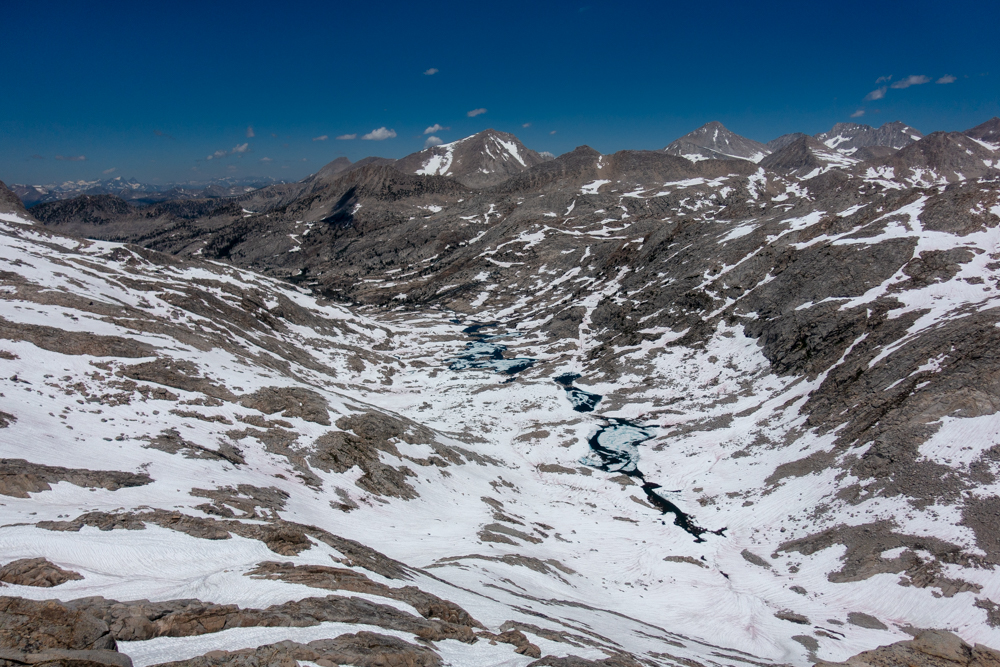
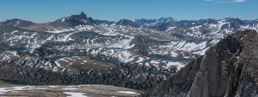
    Matthew pointed me to this thread–I just returned from that general area as well (Pine Creek Pass, Upper French Canyon, Pilot Knob, Gemini, Royce/Merriam).

    I think I have pictures that may help illustrate current conditions.

    My $0.02:

    Dan: Should be no issues. The snow that was troubling Matthew will probably be entirely gone by the time you are there. Puppet Pass should go with no issues. I suspect the Desolation Lake outlet will be more tame (but still might require pause). If I were you, I would probably leave my microspikes at home.

    Brad: Both Feather and White Bear will be the ones to watch. I’d keep an eye on CalTopo’s high res imagery to see if snow lingers on the steep parts of the northern faces. I’d bring microspikes. IMO, the firm AM snow and the soft PM snow both benefit from the additional traction of microspikes when on steeper terrain. If your entire party isn’t well-practiced with ice axes, I’d leave them at home, and acknowledge that you’ll turn around if a steep northern slope looks like it requires a means to arrest. Both Alpine and Lamarck Cols might require an ice axe (check Secor and HST, if you haven’t already).

    Why do you think the drainage of East Fork Bear Creek may be impassable? I have no reason to say otherwise–but just curious.

    Adam

    #3603228
    Adam White
    BPL Member

    @awhite4777

    Locale: On the switchbacks

    Here are a few photos, taken 7/19 to 7/21. Not sure how helpful they will be.

    Humphreys Basin (Knob Lake in foreground)

    Seven Gables Lakes

    Merriam Lake

    Carol Col/Puppet Pass (and Star Col, and Steelhead Pass)


    Enjoy yourselves out there!

    Adam

    #3603240
    Brad Rogers
    BPL Member

    @mocs123

    Locale: Southeast Tennessee

    Thank you Adam!!!

    #3603358
    Dan Magdoff
    BPL Member

    @highsierraguy

    Locale: Northern California

    Adam

    Thanks for the photos, they are super helpful!  Would you be able to orientate me a little on the last photo of Puppet Pass?  Where am I looking from?  Where in the photo is Puppet Pass?


    THANKS!

    #3603367
    Adam White
    BPL Member

    @awhite4777

    Locale: On the switchbacks

    Dan,

    See below:

    The photo was taken from the summit of Royce, looking SE over the shoulder of Merriam Peak.

    #3603417
    Dan Magdoff
    BPL Member

    @highsierraguy

    Locale: Northern California

    Dang!  When did permits become such a hot commodity??  I called the ranger station in Bishop and she informed me that we would pretty much have no chance of snagging a trail permit the day we were planning to head out. (That was our plan). In your guys experiences is this true?  Ive done most of my backpacking out of Florence Lake area and never had an issue getting a last minute permit, so I figured it would be the same from the East Side.  Any suggestions?


    P.S.  That labeled photo was SUPER helpful.  THANKS!

    #3603433
    Pedestrian
    BPL Member

    @pedestrian

    Looks like you haven’t recently sought a permit going in from the more popular East side trail heads……IME those trail head permits usually fill up in advance at this time of year.

    Now if you do just show up you might be able to snag a permit or two given the last minute cancellations.

    You COULD get lucky but there are no guarantees – always best to book in advance. recreation.gov is your friend!

    #3603565
    Brad Rogers
    BPL Member

    @mocs123

    Locale: Southeast Tennessee

    @highsierraguy – I tried to get permits for the Southern Sierra High Route four days after they started taking reservations and all the advance permits were booked.  We are hoping for two walk up permits ourselves and you have me worried now.   This is why I prefer WRR to the Sierra.

    We could do our route either direction so we could do Bishop Pass or Piute Pass permits for 8/4.

    #3603568
    Brad Rogers
    BPL Member

    @mocs123

    Locale: Southeast Tennessee

    BTW: Our plan (assuming we get the permit for North Lake) is to camp around Puppet Lake / Elba Lake on 8/4 and in Bear Lakes Basin on 8/5 after we hit the trail at Italy Lake and make our way to the JMT, we will just camp wherever we are that night, with no real goal other then to exit via Bishop Pass on 8/10, hitch over to North Lake, get the rental car and drive back to Las Vegas that night.

    If we end up with permits starting at South Lake instead we will reverse it camping in Bear Lakes Basin on 8/8 and probably somewhere in Humphrey’s on 8/9.

    #3604454
    Brad Rogers
    BPL Member

    @mocs123

    Locale: Southeast Tennessee

    We were all set to try for a walkup permit and I happed to just check the website again and they had two spots for South Lake on 8/4 so I snagged them.  We will then be reversing our route.

    Well likely be camping in Dusy Basin on 8/4, Evolution Basin on 8/5, Evolution Valley 8/6, the far side of Sheldon Pass on 8/7, in Bear Lakes Basin in 8/8 and Humphrey’s Basin on 8/9.  That should give a few more days for White Bear Pass, Feather Pass, and Carrol Col to melt out.  I think I’ve just about decided to forgo crampons and an ice ax and just bring Microspikes.

    Will we have a chance of running into any BPL’s those dates?

    #3604460
    Dan Magdoff
    BPL Member

    @highsierraguy

    Locale: Northern California

    Brad

    Thats awesome!  We didn’t want to risk trying to get one of the last minute permits.  So we are going to go into the Sierra from the west side where permits are easier to come by.  We are going to head towards Graveyard Lakes and then head over one of the unnamed passed towards a few of the lakes kinda Northwest of the Graveyard lakes and explore around.


    Sounds like you’re gonna have an awesome trip…cant wait to hear all about it.  I am guessing you aren’t going to have much trouble with snow on any of those passes…it seems to be melting pretty quick now. Have fun and be safe!

    #3606243
    Stanley L
    BPL Member

    @2befree52-2

    Brad:

    On August 24 I am starting the trip you first described above (obtained my permits online 6 mos ago; reserved 4 permits at midnight of the first possible day and the remaining permits were gone by 12:15 a.m.).  Our trip is Piute Pass, Carol Col, Feather Pass, Bear Canyon, Seldon Pass, Evolution Valley, and out over Larmarck Col.  I have done most of this route over the years, although Carol Col/Puppet Pass and Feather Pass are new.  I would be interested to know what conditions you encountered on your trip.

    #3606291
    Brad Rogers
    BPL Member

    @mocs123

    Locale: Southeast Tennessee

    White Bear Pass was steep coming up from the west but was snow free.  There was snow on the east side and it was steep but short.  Looking at it from below, I think it could be avoided coming from the east.

    We spiked up for the final climb to Feather Pass from the west.  It had a long snowy sun cupped accent, but it could have been done without Microspikes.  The east side of the pass barely had any snow and no spikes would be needed.

    Skirting around LaSalle Lake had some snow and we did spike up as it was some decently steep sidehilling.  Probably easier than the talus I imagine is underneeth though.

    Puppet pass was steep on the west side.  We followed a cliff face up the west side and it had one place where it had a class 3 move or two, probably avoidable if you took a better line.  The east side was straightforward and had a use trail up to a high plateau and would be an easy walk up to the pass.

    Piute had maybe 100 yards of snow at the top but was mostly snow free.

    The snow was melting fast.  You may just see remnants of what we saw.

Viewing 25 posts - 1 through 25 (of 31 total)
  • You must be logged in to reply to this topic.
Forum Posting

A Membership is required to post in the forums. Login or become a member to post in the member forums!

Get the Newsletter

Get our free Handbook and Receive our weekly newsletter to see what's new at Backpacking Light!

Gear Research & Discovery Tools


Loading...