Home › Forums › Campfire › Photo Gallery › Clark Range – Merced River, Yosemite NP
-
AuthorPosts
-
Aug 11, 2020 at 12:52 pm #3670392
Vernal & Liberty Cap:
Illiloutte Creek:
Upper Merced Pass Lake:
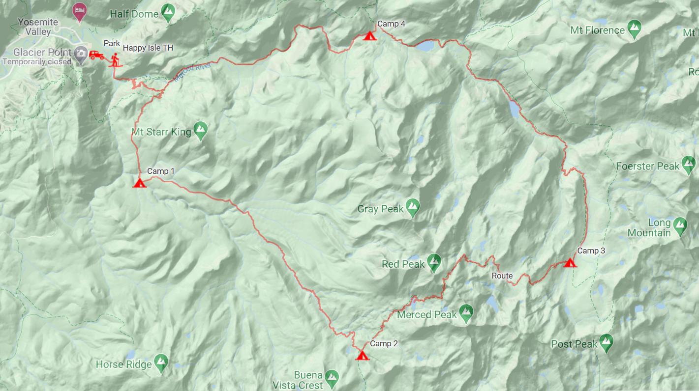
Camp:
Lower Ottoway Lake:
Heading up (from the south) Red Peak Pass:
Red Peak Pass (looking south):
Looking east from RPP towards Minarets:
Pano looking up towards RPP from the north side:
Camp near Triple Peak Fork:
Triple Peak Fork:
Heading to Washburn:
Nice set of falls:
Washburn Lake:
Outlet of Merced Lake:
Camp near Echo Valley:
Half of a famous dome:
Jan 23, 2021 at 7:46 pm #3695259A few more:
Jan 23, 2021 at 7:51 pm #3695261Jan 23, 2021 at 8:04 pm #3695264Jan 23, 2021 at 9:25 pm #3695270Nice shots Alex, looks like a great trip.
Jan 23, 2021 at 10:06 pm #3695274That Jeffrey Pine forest below Washburn and before Merced Lake is fantastic.
I used to go to that area and then up in a Northerly direction in the early spring for many years. People aren’t around at all in the spring! Except your trip went over Red Peaks Pass, which is no piece of cake when covered in snow. I love this country! Triple divide country in and around what you hiked is very fine indeed. So is the trail that you followed. People are down on it because it’s not 12,000 foot moonscapesf–altho Reds Peak is pretty high. Personally, I like mixed country–that is, granite with biology–trees, animals, flowers, moss. Not just rocks.
It looks like you caught great weather and had a great trip. Thanks for the photos.
Jan 24, 2021 at 1:09 pm #3695361Thanks, fellas. This was a really fun trip. Although, we were hoping to extend it by one more night and go check out the headwaters of the Lyell Fork of the Merced, but my friend had obligations that required him back at home. I hope to check it out this year.
Jan 24, 2021 at 5:16 pm #3695405Alex: did you want to explore the headwaters from the Marie lake/donahue side…or from the “high route” trail that takes you to Rafferty creek and Vogelasang? The latter is very very nice and not well known…
Jan 25, 2021 at 8:30 pm #3695591The latter, but coming from Red Peak Pass heading north, then east across Triple Peak Fork of the Merced, up the canyon wall, and then heading north past Harriet Lake. Once we reach the Lyell Fork, step off the trail and follow it (loosely) upstream. Our return to the Valley would take us along the “high route” rim above Washburn Lake, dropping down at Lewis Creek, and onto Merced Lake.
Jan 25, 2021 at 8:54 pm #3695597Oops I meant Lewis Creek…
There’s a series of benches zig zagging to the left (west?) of the Lyell stream that gives easier access to the upper mountain than bushwhacking up the stream. The route is more obvious looking down from up top.
that’s a nice trip you have planned. The back side of Lyell high up is one of the best spots in the Sierra.
I’ve f0und crossing the Lyell fork at the trail in early season to be dangerous. there’s a better crossing 1/4 mile up.
Jan 25, 2021 at 11:22 pm #3695615Thanks, jscott. I appreciate the route advice. I haven’t decided on a starting point for this year’s trip to the area, but I’m leaning towards Tuolumne Meadows (assuming it’s open) for easy logistics.
Jan 26, 2021 at 9:50 am #3695682Great photos. Looks like a fine trip.
-
AuthorPosts
- You must be logged in to reply to this topic.