I’m new to the NYC metro area and am looking to get my feet on the ground somewhere in the Appalachians (do the Catskills count as “Appalachians”?) this spring/summer. I’m thinking of maybe starting off with a 2-3 day trip, around 30-40 miles total. Anyone have any suggestions? I just picked up a guidebook from REI the other (Appalachian Mountain Club?) but haven’t had a chance to digest it all. Thoughts?
Topic
Catskills – loop suggestions?
Become a member to post in the forums.
- This topic has 9 replies, 5 voices, and was last updated 8 years, 11 months ago by
 .
.
Viewing 10 posts - 1 through 10 (of 10 total)
hey david
unfortunately, a good long loop in the catskills is not that easy to come by, at least fully trail-bound.
there are a few fantastic shuttle hikes, the devil’s path and escarpment trail being the two most well known.
the classic loop is slide/cornell/wittenberg, but that’s only 17ish miles. it’s possible to widen that loop by going off trail, but bushwacking in dense forest is a special vocation.
you should definitely buy the ny/nj trail conference maps, they are the definitive source: https://www.nynjtc.org/maps/catskill-trails-map
and i haven’t studied it much, but it’s interesting that technically the catskills aren’t even “mountains.”
from dr. wikipedia:
“The Allegheny Plateau,<sup id=”cite_ref-1″ class=”reference”>[1]</sup> the Cumberland Plateau,<sup id=”cite_ref-2″ class=”reference”>[2]</sup> the Ozark Plateau,<sup id=”cite_ref-3″ class=”reference”>[3]</sup> and the Catskill Mountains<sup id=”cite_ref-4″ class=”reference”>[4]</sup> in the United States and the Blue Mountains in Australia are examples of dissected plateaus formed after regional uplift. These older uplifts have been eroded by creeks and rivers to develop steep relief not immediately distinguishable from mountains. Many areas of the Allegheny Plateau and the Cumberland Plateau, which are at the western edge of the Appalachian Mountains of eastern North America, are called “mountains” but are actually dissected plateaus. One can stand on the top of one of these high “mountains” and note that all the other tops are nearly the same height, which represents the original elevation profile of the plain before uplift, and thereafter the subsequent weather erosion.”
Not a loop, but The Devil’s Path is 24 miles you will remember for the rest of your life. An epic hike.
All the above is true, however I would suggest that WCS is definitely worthy as an introduction to the Catskills, even for fairly advanced backpackers.
You can do the loop from Woodland Valley to Rt 47 (1.05 mi road walk), back into the woods just past Winnisook Hunt/Fish club, make a right turn at the next junction and a left turn to go to Giant Ledge and continue on to Panther Mountain. Go back to Giant Ledge and make a left turn to continue the loop back to Woodland Valley. Rough description, but you will see exactly what I’m talking about when looking at the map.
I would note that 30-40 miles in many places in the Northeast are harder than one might assume. The trails are often considerably rougher and a 2mph average can be expected, and sometimes slower. Better to bite off too little than too much!
There are many more loop opportunities in the Adirondacks, and a good number in Pennsylvania, such as Loyalsock and the Black Forest Trail which has 45 miles of butt-whooping awesomeness.
The Devil’s Path definitely whooped my butt. I’ve been eyeing the Black Forest Trail for some time…need to schedule a trip up north.
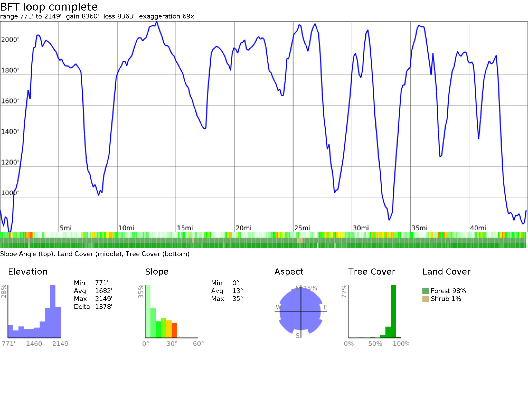
BFT
Of course this mightily compressed, but it gives you some idea of the uppity-downity of it, lol.
But yes, the Devil’s Path is aptly named!
I’ve done it twice in the winter and 1.5 times in summer (fall?).
There is a very interesting story behind the .5 time but I won’t get into that one as it brings back some painful memories, lol!
Hard to believe when you hike it, but it has been done in less than 5 hours as a trail run by one very fit (and surefooted!!) lad.
one very fit (and surefooted!!) lad
I’ve seen that guy on several hikes…banging up a mountain like it was nothing. I hate that guy :)
If you ever try to do CSW in pouring rain, dragging your not-so-determined spouse along, and make some poor gear choices, know that if you decide to bail the couple who run the store in Phoenicia that sells Tibetan stuff have two cabins on that they rent out. Or at least that was the case around 2004.
Someday I’ll get back east for a redo.
And don’t miss Brio’s in Phoenicia… breakfast skillet is superb.
If you take a dog on WCS make sure to bring a climbing harness for him/her and about 30ft of 6mm climbing cord.
Even in good weather there are some ‘interesting’ scrambles—take care not to scrape your Cuben!
Viewing 10 posts - 1 through 10 (of 10 total)
Become a member to post in the forums.
advertisement
Garage Grown Gear Hidden Gems
Discover under-the-radar ultralight gear from small brands.

