Topic
Bob Marshall Open 2019
Forum Posting
A Membership is required to post in the forums. Login or become a member to post in the member forums!
Home › Forums › Campfire › Hiking Partners / Group Trips › Bob Marshall Open 2019
- This topic has 155 replies, 26 voices, and was last updated 5 years, 6 months ago by
 Jane Baack.
-
AuthorPosts
-
Nov 23, 2018 at 2:53 pm #3565447
Dave C just announced the date and start/finish for the 2019 Bob Marshall Open. May 25/19 0800 starting at Swift Reservoir and finishing at Swan Lake campground.
All usual rules apply.
Good luck everyone!
Nov 23, 2018 at 4:48 pm #3565452Damn was really hoping to bring my therapy llamas.
Nov 23, 2018 at 7:53 pm #3565469 Nov 25, 2018 at 7:45 am #3565678
Thanks for the heads up Mike.
I took a look through Caltopo and created a few routes. I had hoped to make this my first year in attendance but my PostBac will take longer than anticipated – through June -and I won’t be able to make it work.
I’m interested in seeing what routes other people come up with to see how they compare to what I envision. The Pasayten is the wilderness I create challenging trips in and I have little experience in the Rockies so this will be a good litmus test and tracking context for route development for the following year.
Nov 26, 2018 at 9:13 pm #3565940not a really straight forward route, add in the very likely potential for very high water and it becomes even less clear- like always, will definitely prove interesting :)
Nov 27, 2018 at 4:47 pm #3566114I just stumbled onto this adventure this summer and I am excited to participate. I am a Kalispell local and will be scouting routes. Its been a few years since i was in the Flottila basin/Twin creek area.
Dec 2, 2018 at 1:40 am #3566834i’m in as long as i don’t draw a Smith River Permit for that week.
Thinking strongly about a packraft this year. Off trail routes West of the Reservoir are looking interesting.
Dec 3, 2018 at 8:29 pm #3567227In the early years my route planning process was governed solely by doing routes I wanted to do personally, and checking out new rivers and creeks. In the last few years it is both satisfying and sad that I can’t plan a non-circuitous route across the Bob without going over extended stretches I’ve been to before, and that the list of promising and unexplored creeks is almost at zero.
So I’ve now pivoted to trying to give everyone else access to new terrain, along with a suite of route options without an obvious first choice. Having routes which disincentivize pack bridges, while still being safe without a boat, is a big part of that.
I’m excited to slog over the northern Swan Range again. The snow and blowdown up there is always impressive.
Dec 3, 2018 at 11:46 pm #3567262I am building a route based on the lack of a pack raft. Could a person use the cable car at Tin Creek as a means to cross the South Fork?
Jan 3, 2019 at 7:56 pm #3571270Tom, I’ve never bothered to stop and see if the cable car was unlocked. Can’t imagine it is, but if not….
Snow pack shaping up decently.
Jan 3, 2019 at 9:14 pm #3571301Dave,
I may just plan on crossing at spotted bear bridge but that would nix my bushwack route from Flotilla into Head creek. There doesnt seem to be much chatter about this trip?
Jan 3, 2019 at 10:56 pm #3571329it’s a wee bit early and often at this stage- routes are kept close to the vest :)
Jan 4, 2019 at 12:41 am #3571358Looks like a nice course. Neat to see floating the Spotted Bear is a plausible option.
Jan 4, 2019 at 3:34 pm #3571446Mike,
10-4 😉👍🏼
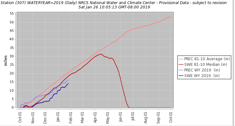
Jan 26, 2019 at 6:13 pm #3575190It has been an odd winter thus far:

Up high the amount of water isn’t (yet) egregiously behind the norm, but there have been lots of warm, windy, and sunny spells. That means that, should this trend continue, low elevation snowpack won’t amount to much, and will thus melt off quickly. Southerly aspects are also likely, as of today, thinner than you’d otherwise suspect. Both of these things could be altered drastically by big snow in the next 2 months. What won’t change is the horrendously unstable snowpack all the sun and wind crusts and depth hoar have created. While they won’t necessarily be big, I expect to see more mid-winter avalanche debris than is typical.
And for everyone who has asked recently, there is no sign up list and no official record of participation. Just show up. In the Instagram age asking the tree falls in the forest question is more important than ever.
Jan 27, 2019 at 11:42 pm #3575411Was in the Upper Little Blackfoot drainage this weekend (not in the Bob, but not overly far away either), way more snow than I expected- at least two feet in the bottom of the drainage (~ 6000′)
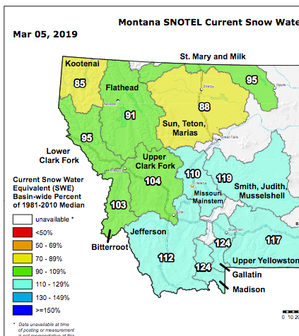
Mar 6, 2019 at 4:18 am #3582017
Things change in a month.
Mar 6, 2019 at 1:41 pm #3582045also low level snow a lot deeper than a month ago
Mar 9, 2019 at 4:24 am #3582531also low level snow a lot deeper than a month ago
And continuing!
Mar 13, 2019 at 10:26 pm #3583352Looking forward to it! Right now I’m planning on floating the middle fork if the water is low enough for Three Forks to at least be worth taking a look at.
I’m planning on getting out there a week-ish before Memorial Day. If any of y’all are around that week and want to do something up in Glacier or in the Bob holler my way. I’d love to meet up for a quick trip before the Open.
Apr 3, 2019 at 7:05 pm #3586844I was in the swan yesterday scouting a optional route and trying out a new set of snow shoes. Not much snow at all below 5500′ and lots above. Lots of prior avalanche activity and tons of debris. Should make for a good time at the end. :)
Apr 3, 2019 at 7:07 pm #3586845^ interesting- thanks!
Apr 6, 2019 at 3:47 am #3587266Not strictly on topic, but anyone know what Swiftcurrent pass usually looks like in late May? I’m thinking about trying a many glacier-highline-Chaney glacier-belly river loop in glacier before the open. Last year a ranger swore up and down to me that Swiftcurrent pass would be impossible until it melted out because of the cliffs, but looking at the map it looks like either of the two creeks that feed bullhead lake should go. I’ll bring crampons and an axe for that sections and because I imagine the highline will be mostly sidehilling on steep snow.
Apr 7, 2019 at 1:07 am #3587422Will – 2 years ago we hiked up to the top end of swiftcurrent right after the open – i know im not the mountain man you are —- but I’ve been over the pass to granite in the summer and there is no way i would want to go there that early . Last year we were there also and the campground wasn’t open yet — still snow around — I’m sure some locals could advise better , but I’d pass
Apr 7, 2019 at 10:01 pm #3587581Ah, thanks Dan. I don’t suppose when you were up there two years ago or when you went over the pass you got a look at that creek that runs down just north of the trail into bullhead lake? Looks promising on google earth, like it cuts a notch into the cliffs that might go with an axe and crampons. I’ll probably just wind up hiking out there and taking a look, can’t hurt to check it out :)
-
AuthorPosts
- You must be logged in to reply to this topic.
Forum Posting
A Membership is required to post in the forums. Login or become a member to post in the member forums!
Our Community Posts are Moderated
Backpacking Light community posts are moderated and here to foster helpful and positive discussions about lightweight backpacking. Please be mindful of our values and boundaries and review our Community Guidelines prior to posting.
Get the Newsletter
Gear Research & Discovery Tools
- Browse our curated Gear Shop
- See the latest Gear Deals and Sales
- Our Recommendations
- Search for Gear on Sale with the Gear Finder
- Used Gear Swap
- Member Gear Reviews and BPL Gear Review Articles
- Browse by Gear Type or Brand.


