Topic

BBST (Big-Big SEKI Loop)

Viewing 6 posts - 1 through 6 (of 6 total)
PostedJun 3, 2016 at 4:13 pm

Hello folks,

Earlier this year, I came upon the BST. Needless to say, I was inspired. I was able to secure a few weeks off this summer, and will be enjoying it in the Sierra.

The BST was perfect for me, However, I really wanted to check Whitney out. However, since I understand that we are very protective of the term BST and any deviations from it are grounds for immediate beheading, I added an extra “B” to it, so as not to ruffle any feathers :)

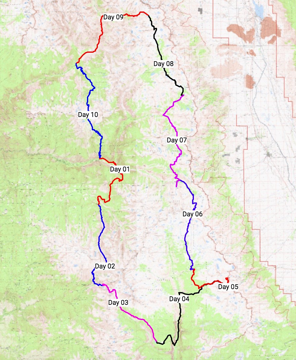
This plan will follow the BST route all the way, with the exception of getting off-trail by Whitney Creek. At that point, I will be working my way across to the PCT/Crabtree Meadow.

This trip is sketched out in comfortable, under 20 mi days, for 10 days total. I am likely going to be going at a faster pace, so slight adjustments may happen. However, I worked in a 2-day buffer, in the case I feel like taking a short day and sucking up the air.

Caltopo here: http://caltopo.com/m/17FM

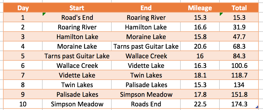
(Table distances seem to be a bit off)

Comment away – particularly anyone that has cut across through Whitney Creek lately (I hear there might have been some ground shift due to snow in the past year or two that might have affected the route, but cannot find any confirmation).

PostedJun 3, 2016 at 4:14 pm

Woops… Cheesed the title, and can’t find the Edit button.

And I called the darn thing BST a million times… I might just rename it to the BeaSTrail.

Nick Otis BPL Member
PostedJun 10, 2016 at 10:39 pm

God, this looks fun! Off-topic: where are you going to resupply?

Owen M BPL Member
PostedJun 10, 2016 at 11:00 pm

Looks awesome!  It appears that Gonzalo isn’t planning a resupply, but since his first few days won’t legally require a bear canister, he can get away with using an ursack or the bear boxes that will be available at his first three campsites.  Here’s a helpful link for planning trips around those boxes: http://climber.org/data/BearBoxes/map.html

If anyone is looking for a place to resupply on the BBeaSTrail, you can start on the Eastern Sierra side at Onion Valley and mail packages to the store at Cedar Grove in Kings Canyon.  It is a few miles down the road from Road’s End, so you’ll need to walk or hitch.  That will add 10 or so miles to the whole trip, making it a big big big seki loop.  I haven’t called them this year to ask if they’re still accepting packages, so it would be wise to do that first.  Of course, resupplies and alternate starting points are not allowed with the Big Seki Loop.

PostedJun 11, 2016 at 3:39 am

Owen – as to the bear can on the first few days, do you know whether the rangers are very clear on this matter? It gets boring when I have to explain police officers that their state allows pedestrians to walk on the side of the interstate. I don’t want to have to do the same thing with bear cans up in here haha.


Nick: Owen is right as to my no-resupply map. I considered starting at Onion Valley. My only doubt as to that is going straight off the bat into +10k elevation with no acclimatization. Save for a couple of passes, the first three days keeps you under 8K if starting at Roads End.

Owen M BPL Member
PostedJun 12, 2016 at 2:17 pm

I’ve never been in that situation, but the rangers I’ve talked with in SEKI always seem to know the zones where canisters are required. They’ve seemed most concerned with people hiking the Rae Lakes Loop. If you’re concerned, you could print out the canister-requirement map from their website and eiter bring it with you or show it to the ranger issuing your permit and having them write on the permit when you will be entering canister country. I don’t think it will be an issue as long as you properly store your food those first few nights in either the large bear boxes, an ursack, or a proper hang. If you seem knowledgable and like you know what you’re doing, I seriously doubt they’ll hassle you for not having a canister outside of the required zone.

Viewing 6 posts - 1 through 6 (of 6 total)
Loading...