One of my regular hiking buddies (and the most reliable one) is keen to do the AT one of these seasons. I’ve read quite a bit about it, and watched some of the YouTubers. A lot of the trail just looks really, really boring to me. That long green tunnel thing. I like a day or two of that, but from the videos it really looks tedious, with rare views, and none if it’s raining. For those who’ve done it and loved it, is there more variety than the videos appear to show? After enjoying the scenery and flowers while hiking in the Sierra, and southwest deserts, and Alaska, maybe I’m spoiled for the AT. I did enjoy hiking in the Catskills last fall though. Maybe it’s just getting through the southern stretch of the AT that’s not so exciting and it gets better further north.
Topic
Appalachian trail compared to others
Become a member to post in the forums.
- This topic has 19 replies, 15 voices, and was last updated 3 years, 3 months ago by
 .
.
Yep, you’re spoiled. You’ve seen the best.
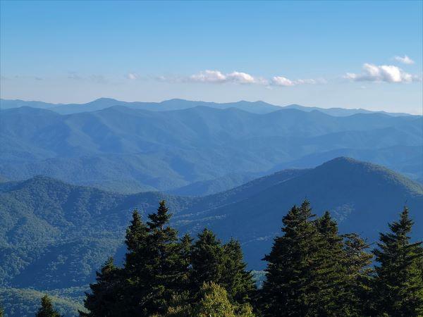
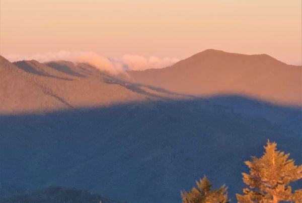
If you liked the Catskills, then expect the Smokies and Blue Ridge mountains to be roughly similar. They are baby “mountains” compared to Rockies, Sierras, and those biguns in Alaska. But they are beautiful in their own way. More “pretty” than “spectacular”.
Vermont, New Hampshire, and Maine have the larger mountains (the trail skips the Adirondacks of New York State, which are also 5,000-foot-class). They are still small compared to the West, but they at least resemble real mountains.
Expect some of the trails to be weirdly steeper. Perhaps because the hills are smaller, trails often go more or less straight up. In the West you get more switchbacks because few people could climb them without it.
Bugs and humidity are common. High winds less common. Ponchos perform better in warm humidity than GoreTex, in my experience. Amazon sells ponchos with full-length front zippers for extra ventilation; that’s my personal favorite in warm humid rain. The Packa unsurprisingly comes from Georgia. Whatever shelter you carry, make sure to have mosquito netting.
If you wanted to just do some sections I wouldn’t blame you. Great Smoky National Park (NC and TN) are some of the best of the baby mountains, Mt Baxter in Maine, maybe some of the White Mountains in NH for higher elevations.
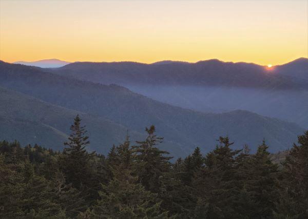
As Bill says it is steeper with more elevation gain than the western long trails. Start in early spring and follow the spring and the leaves north. Best done when the leaves are off the trees or just getting going. Beautiful spring flowers and much bigger views, fewer bugs then too.
Sounds like you’re looking for great scenery and not notching your belt by doing 2200 miles never very far from a Walmart. I’ve been in every county that contains or is adjacent to the AT (and every borough in Alaska). The AT is mostly low, geological old, smooth, greenery-covered “mountains” (really, hills by western standards).
I’d say do the NH and ME sections only. Or do the higher elevation southern sections before they “leaf out” in Spring. Going northbound and Spring and the leaves blocking your view wouldn’t overtake you as quickly. And, if you still have some freezing nights, those seems mild to an Alaskan but knocks down the mosquitos, ticks, and chiggers.
The White Mountains in NH can be quite challenging, but still less powerfully or breathtakingly (?) scenic than out west.
And never underestimate Mt. Washington in NH as to weather and conditions. It has some of the most extreme weather on the typically, year round inhabited part of the planet, despite that it is a very modest 6, 288 ft. (I would love to do a winter trip there sometime, but I don’t know anybody who would do it with me, and I’m hesitant to do it by myself).
(I spent most of my childhood living in northern’ish New England and used to regularly hike in the White Mountains, but have also hiked the CT and some other areas out west ranging from AK, to WA, OR, CA, etc though far more briefly than the CT).
Sure, on paper (or youtube) the AT is pretty boring compared to the others. The AT is a different kind of fun. You learn to enjoy what the AT gives you and you have to have that mentality otherwise you will just be disappointed.
The PCT takes the best of both the AT and CDT and leaves a bunch of the worst of those trails. Leaves you with a fairly polished hiking experience. The PCT is easier in most regards to “through hiking,” imo.
The AT changed who I was. The CDT made me who I am. The PCT is fun…lol
I’ll second Justin’s cautions about the White Mountains in general and Mount Washington in particular. Sometimes a summer day is a lovely summer day, but I’ve also had weather as bad as in the Aleutians (“Birthplace of the winds”) on a summer day on Mount Washington – 60 mph winds, 4-foot visibility. Walking around at a distinct angle off vertical and by touch with my hand out in front of me so as not to bump into things.
Then, an hour later, it was back to a lovely summer day with 100+ mile views.
The AT ranges from boardwalks and old towpaths & RR grades to extended pitches of class 3 climbing, often including man-made aids. As others said, it is not a western trail graded and groomed for equines.
It is nonetheless wonderful in many places.
And social, very highly social. So many people hiking. Through. Section. Day. So many towns and cities and roadside stands. At Dragon’s Tooth, I was held up 2 hours by VA Tech students out for a weekend climb up and down the rebar-aided rock face.
Echoing David and others on the Whites, when I traversed in 2017, everyday had gusts above 50 mph reported at Huts along the trail, some to 75 mph. I hiked down the waterfall, literally, N of Moosilauke in a hard rain. The long climb up to the Kinsmans was in continued rain making the trail a multimile creek. The, along that ridge, long stretches of bog boards were a foot underwater, and I found abandoned footwear. Later, my hike along Franconia Ridge was cairn to cairn in a whiteout of fog/mist with wind chill of 20F. Below Mt Washington, I fortunately caught a walk-up 1/2 price bunk at Lake of Clouds to avoid tenting in a fearsomely loud, gusty 2″ (measured) thunderstorm that others called their worst ever night on any trail.
Broken arms and legs, plus sprains evac’ed past me.
And my trip through Whites was all in August!
Still, I wouldn’t trade for the memories.
For the AT, pick your spots, and times.
Every long trail has its own personality. I’ve hike sections in every state the AT goes through. For some reason, not sure why, I particularly enjoyed my time in Pennsylvania. I don’t hear that often.
I’ve also done extensive hiking in the Sierra Nevada, the Rockies, and other western mountain ranges. They’re all different and at times similar.
I’ve also spent a good part of 4 decades wandering in deserts, off trail. That I enjoy the most and am probably a minority.
Any trail is better than staying at home.
I might do a section in the fall. As you know October and November are cold in Alaska (and the west). But you could catch some nice (by your standards) weather and it won’t be as crowded if you aren’t paci t with the thru hiker crowd.
Done sections in every state and all of NC. I’d say it’s like the Title of Bryson’s book; a long walk in the woods. Never done anything like a long through hike which seems in some respects like it must have aspects of a pilgrimage of introspection and perseverance. But if you like trees in all forms and varieties, the bio-diversity covers Arctic to nearly sub-tropical.
Like Luke said above I ‘ve met lots of people finishing up in December in NC heading for Georgia. I think they start @ August at Katahdin and head south. Avoids the blackflies and the highest parts are leaf free for the views. BTW a little NC lore. There are I think 55 named peaks above 6000’ east of the Mississippi. 1 is solely in Tennessee. 1 is solely in New Hampshire. The other are completely in NC or shared with Tennessee. I’ve been on them all.
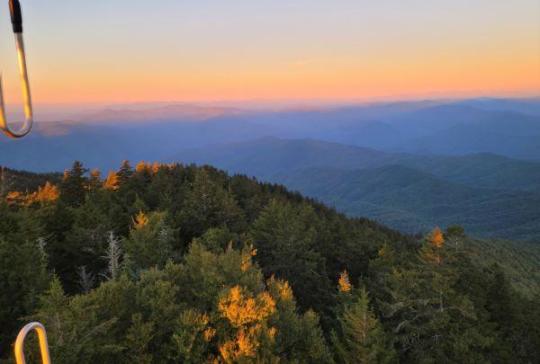
Many triple crowners (several good friends) go back to hike the AT again. AT is about the people, the social aspect of trail family and shared experiences. Trails Days in Damascus VA is incomparable for reuniting with trail friends. I lived out west and love the vast vistas, the Apps have their charms. Spring wildflowers, summer trails lined with rhododendren blooms, blackberries and blueberries on the trail. Trail Angels at many roadcrossings on weekends, ad infinitum. Love wherever you hike for its own beauty. Example: 2 weeks hiking in Peruvian Andes blows away everything but Himalayas. But I loved hiking the NH Whites just as much. And Olympic is sublime. Just throw a dart and dive in full tilt to what comes up.
If you’re looking for the big mountains and views like you see out west, you’ll be disappointed, but it does have it’s own alure. The range of biodiversity, particularly places like the Smokies is pretty unique. I’ve done the first ~800 miles of the AT as section hikes until I got too far north to make long weekend trips worthwhile – too much driving for a few days in the woods and went back and hiked the BMT. If they are planning on thru-hiking, the trail can be pretty crowded, especially around the shelters, where hikers tend to gather. Personally, that’s not my thing, but some people really like the social aspect of it – and perhaps I would too if I was thru hiking. I generally go backpacking for a weekend or a week long trip to get away, not get around a bunch of people.
The mountains are not that high, but the trails are difficult for western standards. Ryan Jordan wrote an article years ago (~2005) where he hiked part of the AT and swore he’d never be back, citing the difficult trails, rain, humidity, no views, etc. I can’t find it now, but I remember it being pretty comical.
There’s a figure 8 loop one could make using the At and the BMT and a couple other trails along with the NC MST that would be over 800 miles and include all of the highest Ridgelines in the east except the crest of the presidentials, dramatic features like Linville Gorge, and Grandfather mountain and some of the best forest. Basically follow the AT south from Elk Gap on 19E at the NC TN border to Fontana. Then pick up the BMT at Fontana and follow to just past Snowbird Creek and take the Snowbird Ridgeline or down the Creek and back up to the Snowbird Ridgeline and proceed north to @ Beachertown on the Nantahala and from there use the Bartram Trail and a couple of connectors to get to the Chunky Gal and back over to the AT at the NC/GA line. (that last part after leaving the BMT to get back to the At via at least part of the Chunky Gal I’m exploring this summer and it’s potentially a little unorthodox. Goes through some of TeePee Walter’s home turf. From there go north on the AT back to Fontana and past the Dam take the BMT to its jct with the MST and from there North on the MST to past Grandfather to Boones Fork. This basically finishes the figure 8 loop. There’s a couple of places along the MST where some side loops would be worthwhile like breaking off the MST near Mt Hardy and going over to Cold Mt. and back and also taking a side loop off the MST to take in the crest of the Black Mountains and again looping back to the MST. From Boones Fork head back south and west over Grandfather. From the south end of Grandfather back over to 19E at the NC /TN line is @ 12 miles. Get a uber or call the folks at Mountain Harbour. The NC Great Eight; an @ 800 mile figure 8 loop. Does wander into Tennessee a little ;)
I’ve been putting this together on Caltopo and plan to work out a few of the missing links or tweaks this summer and fall. Be interested to get any comments or ideas. Maybe I should start a thread for starters?
Hey OBX…..shush…… NC backpacking is terrible… really. No..really. I wouldn’t want folks to be disappointed!
Russ from NC, AT 83
PS – That sounds like an interesting project. Please follow through with another thread! Thanks!
OBX that sounds like a cool project. I’d do that before hiking the AT for sure.
We did a much smaller loop by linking the AT through Grayson Highlands with the old Iron Mountain Trail. It was great. We basically had the Iron Mtn trail to ourselves. The AT was more crowded but the views and variety made it worth it.
I also have been told that there’s a project in Va /WVA to run a trail along the Allegheny ridge or connect what already or partially exists .This could be used to make a loop with the AT. S’all Good man.
Never hiked it but my tentative plan is section hiking in the fall season to minimize any buggy and muggy experiences.
One member of my hiking club thru hiked northbound to partly avoid those conditions, but had unplanned town stays as even those southern mountains can get cold with the right type of weather front (single digit Fahrenheit).
I might come back. With a twist. I recently acquired a Seek Outside Guardian hot tent and a used tigoat stove. The whole package is roughly 4 pounds. We could comfortably hot tent while doing leisurely winter hikes along the AT.
The A.T has its own charm. I enjoy the physical and emotional challenges of backpacking. Yes, the A.T is mostly the green tunnel but I enjoy it as much as the sierras or the Rockies. It’s all good.
Become a member to post in the forums.
 Carbon Fiber Power Bank20,000 mAh power bank with a lightweight carbon-fiber shell.