I’ve got all my trips planned for this year, and so I am already looking ahead to 2018. I have yet to hike the Wind River Range, and after hiking in the Tetons two years ago, I think that’s where I’m going to take my big trip next year. My requirements are 6 days maximum, average no more than 10 mi/day, and although I am pretty comfortable with off trail travel, a few of my companions may not be, so mostly on trail is preferred. However, a spectacular off trail section that is pretty straightforward would probably make the cut. Priorities are big scenery and fishing (prefer fly, but will probably take spinning rods as well). After scouring the internet, I’ve put together the following itinerary. The hardest decision was whether to include Titcomb and Indian Basins or Cirque of the Towers. I don’t see how we could do both, so I guess I’ll just have to make a return trip in a year or two. I’d love some feedback, and any can’t miss areas that I should consider for either fishing or the view. Thanks.
Topic
Advice on my first Wind River trip
Become a member to post in the forums.
- This topic has 10 replies, 7 voices, and was last updated 8 years, 11 months ago by
 .
.
I chose the camping sites based more on mileage rather that whether it was an ideal spot, so I’d definitely consider shifting those around a bit. We’d probably tackle this in mid-late August.
Skip Indian Basin. It’s beautiful, but not as spectacular as Titcomb Basin IMO.
For off trail travel, I would suggest Knapsack Col into Titcomb basin or Texas Pass into the Cirque (if you decide to do that instead). Knapsack is challenging. Climbing up moderately steep on small tallus, but is straight forward. The back side is a little more challenging, but if you keep heading north along the ridge you can find an easier route down. You could do it on Day 3 and then camp in the Titcomb. The north end of the lakes are grassy and perfect for a campsite.
If you start in the south instead, Texas Pass is not challenging. Practically on-trail travel, just not marked on the map. Plus you get to come into the Cirque which would be a nice end to the trip, despite the crowds that you would encounter on the way out.
For fishing, I’m little help. I did catch a 12″ rainbow on Victor Lake (or North Fork Lake….can’t remember which).
I did a similar route about five years ago. You will see a lot of country!
The trail out of Long Lake on Day 1 is in slightly rough shape but very walkable. There are (or were) quite a few large fallen trees on the trail between Crow’s Nest Lookout and Glimpse Lake.
Late during Day 2 you will notice a change in scenery as you approach the higher country.
Titcomb and Indian Basins have different characters. Both are worth seeing. Indian is “prettier”, grassier, more welcoming. Titcomb is massive, brooding, impressive, makes you feel insignificant.
Here are a few easy off-trail suggestions which I have done. (1) parallel Fremont Creek/Island Lake between the trail and the Lake. (2) visit Mistake Lake in the Titcomb Basin. (3) walk to Lake Nelson, east of Seneca Lake. Once you get a feel for the range you can visualize and find many off-trail possibilities.
Both Titcomb and Indian are on my list for late August. Maybe we will bump into each other. Happy travels!
To my taste the itinerary is lacking a culminating highpoint. Nothing like peering over a significant divide or summiting a peak.
The easiest of such to include is Indian Pass, which scores high on several fronts: It on the continental divide itself. There’s (still) a sizable glacier on the backside. And finally it’s an easy hike as major passes go.
On day 3 (if you are comfortable with the off trail travel) from Elbow Lake I would go north over Shannon Pass to Peak Lake and then east over Knapsack Col into Titcomb Basin. It’s a moderate pass but will give you that crux of the trip moment. If the weather is nice I might try and camp in Titcomb Basin or Indian Basin. In 2012 I had Titcomb Basin all to myself and it was one of the best camps I have ever had.
Island Lake was a zoo when I passed through.
I camped about where you show on Elbow Lake, and though it might not be my favorite campsite ever, it certainly wasn’t bad.
If you don’t have it already, I recommend you pick up Nancy Pallisters book on Wind River Range
Knapsack Col looks like a definite possibility. The way up looks pretty straightforward, but on the way down, is it best to go over the twins glacier, or skirt around the edge? Are we likely to need micro spikes and ice axe, or will trekking poles suffice? Thanks for the recommendations. Any thoughts on can’t miss campsites? If we go over Knapsack Col, we’d likely camp at the north end of Titcomb, and then maybe camp the next day in Indian, then head south for the trailhead. Or just day hike Indian and Camp down near Seneca or Little Seneca Lakes. That would shorten our hike out by a bit.
It’s usually easier to go down on north end of the col at the edge of the glacier or even in the rocks for the first bit. I have never needed micro spikes or axe but conditions vary as well as comfort level. Micro spikes and trekking poles should suffice, but an update from folks here before you leave would be the best way to determine if the micro spikes are needed.
When we did Knapsack east to west in early August ’15 it was nothing more than a hike over a pass. The main challenge was putting one foot in front of the other, as we had done Alpine Lakes Pass and Indian Pass earlier that day.
With the conditions we found, one goes from left to right below the snowbank at the pass. A steep trail can be seen up thru the scree/talus. Crossing the snowfield at the base is clearly not a steep affair.
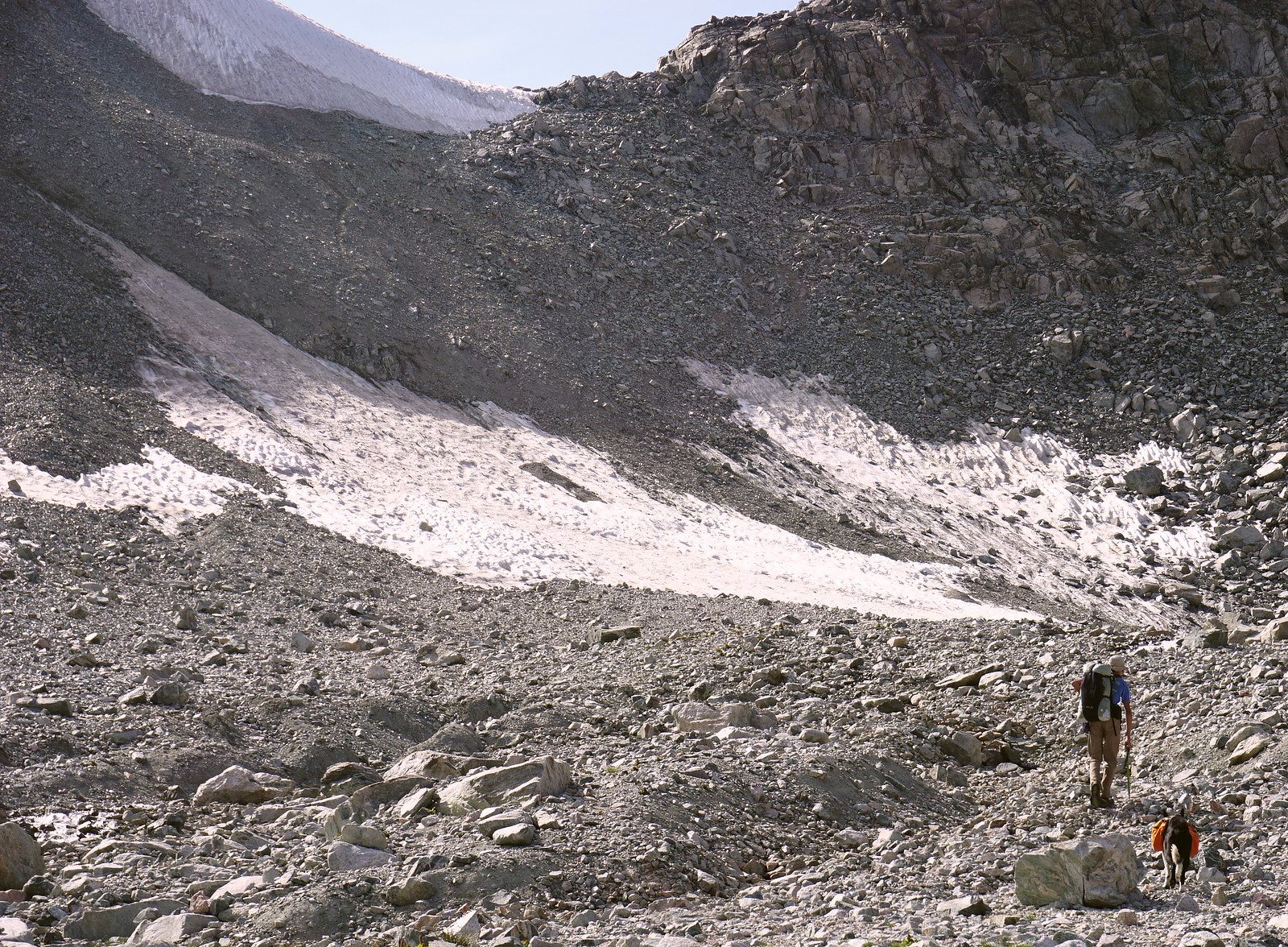
When I crossed in 2012 I had microspikes with me for the Knifrpoint Glacier traverse but didn’t even think about putting them on while crossing Knapsack Col. There isn’t much left of it to be honest and the rest is covered be rock. There was a small snowfield to cross near the start of the talus hopping at the top, but no ice ax or microspikes needed.
Honestly the sketchiest part of that whole section was crossing the rock slide at Peak Lake.
Hiking the CDT through the Winds isn’t bad. We did it a few years ago. It’s easy to include Titcomb.
Become a member to post in the forums.
 Anniversary SaleMay 15 to 25 - REI's biggest sale of the year.