In part three of his series on modern wildfires, Rex Sanders uses video and animation to explore just how crazy this wildfire season has been.
Topic
Become a member to post in the forums.
In part three of his series on modern wildfires, Rex Sanders uses video and animation to explore just how crazy this wildfire season has been.
I’m writing this from Estes Park, after meetings here today.
The absolute terror that was experienced by my friends and colleagues here by the East Troublesome fire’s run towards Estes Park that night – I can’t put it into words. Darkness in the middle of the day. AQI values so high they led the world. Worry about an entire (not small) town getting obliterated.
Nature came through and brought snow, and the fire slowed when it hit the burn scars from a few years ago. But fear here – it’s a real deal. Lots of dry pine all around…all the way to town.
I talked to a fire chief in Safeway last night and asked him about what he thought about the ground fuel suppression efforts in RMNP – do they work?
He laughed – “not with this fire…” he said fire tornadoes tossed burning trees into the air and catapulted them several hundred yards to create new spot fires. Whoa!
They don’t really understand how the fire crossed the barren Continental Divide. Unprecedented fire behavior. But he suggested that “if it was just a flying spark or ember” – then we may not be aggressive enough to close forests in the summer to minimize activity that could create errant sparks.
Let it burn? Healthy for forests, sure! Stephanie and I drove to Bobcat Ridge yesterday to look at the edge of the Cameron Peak fire and – there’s new plants – including PINES – already poking through the burn scars. Made me sad but happy at the same time. Nature is resilient.
But fires impact real people. It’s heart-wrenching to witness the loss of anyone’s home.
Complex issues, real impact on people. Mitigate climate change may help. Colder temps = more dead beetles, with perhaps healthier forests with less “need” for “more frequent” fire restoration – and of course the resulting human trauma. Seems like a reasonable balance.
Thanks Rex for bringing attention to this issue in such a creative way! More info and awareness is better.
He laughed – “not with this fire…” he said fire tornadoes tossed burning trees into the air and catapulted them several hundred yards to create new spot fires. Whoa!
Last big fire here (near us) saw the fire turn up at the top of the hill on the right, and jump straight across onto the face on the left.

Control burns and fire trails have absolutely NO HOPE. The fire front goes straight over the top of them.
In fact, there is growing evidence that so-called ‘control burns’ just leave more dead kindling in place for the next fire. The burn kills off a lot of light green scrub.
Cheers
In 2017 the Eagle Creek Fire jumped the Columbia River!
It is possible that California and Oregon could be consumed in one massive firestorm.
The Fire in Napa Valley this year jumped over a mile across green vineyards to catch the hills on the far side of the valley on fire…and expand into Sonoma County.
Yeah, we sometimes get charred leaves falling on us from a fire miles away.
Cheers
In these recent fires in Oregon there were lots of houses and buildings that survived, even in areas that looked devastated
Perimeter of cleared area, non flammable building materials, small things are important like making sure there aren’t pine needles in the gutters and eave vents
I’ve been through lots of recently burned areas and yeah, it grows back
There may be areas that used to have big conifers that become meadows – that’s the effect of global warming
During the last red flag warning we had in Northern California, there were wind gusts of up to 140 mph in Tahoe, 90 mph in Napa. And the humidity level was 8%,
If you wanted to incinerate the Earth, that would be a great way to start.
For these articles and video, I left out most of the “Why?” descriptions, because others have done a better job.
Here’s a 2017 TED talk by research ecologist Paul Hessburg, with very compelling explanations of our new wildfire era, touching on most of the major causes. It’s also uncomfortably prophetic to watch in late 2020.

— Rex
Thanks much for the set of articles. Very helpful.
I live south of San Francisco, and hike in the redwood forests in this region. I found the mapping program GAIA to be useful for being able to see an overlay of fire information versus trails I hike.
In my experience, the GAIA data is not updated fast enough to use it for in field navigation of fire zones. The maps seemed to update a half do or so after the satellite image updated. But it did help me follow the news reports, and see how close the fire was coming to areas where I hike.
My screenshots below are from the premium version of their product. A disclaimer, I do beta testing for GAIA, so don’t pay the standard price for their app.
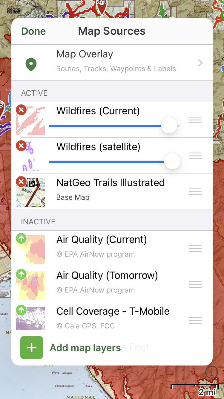
Yeah @art-black I noticed that too when trying to monitor fires this year with Gaia GPS.
But I love those layers in Gaia – they are great for route planning. And I like that they separate “current” (season) wildfires from historical data.
Ryan wrote:
“And I like that they [Gaia] separate “current” (season) wildfires from historical data.”
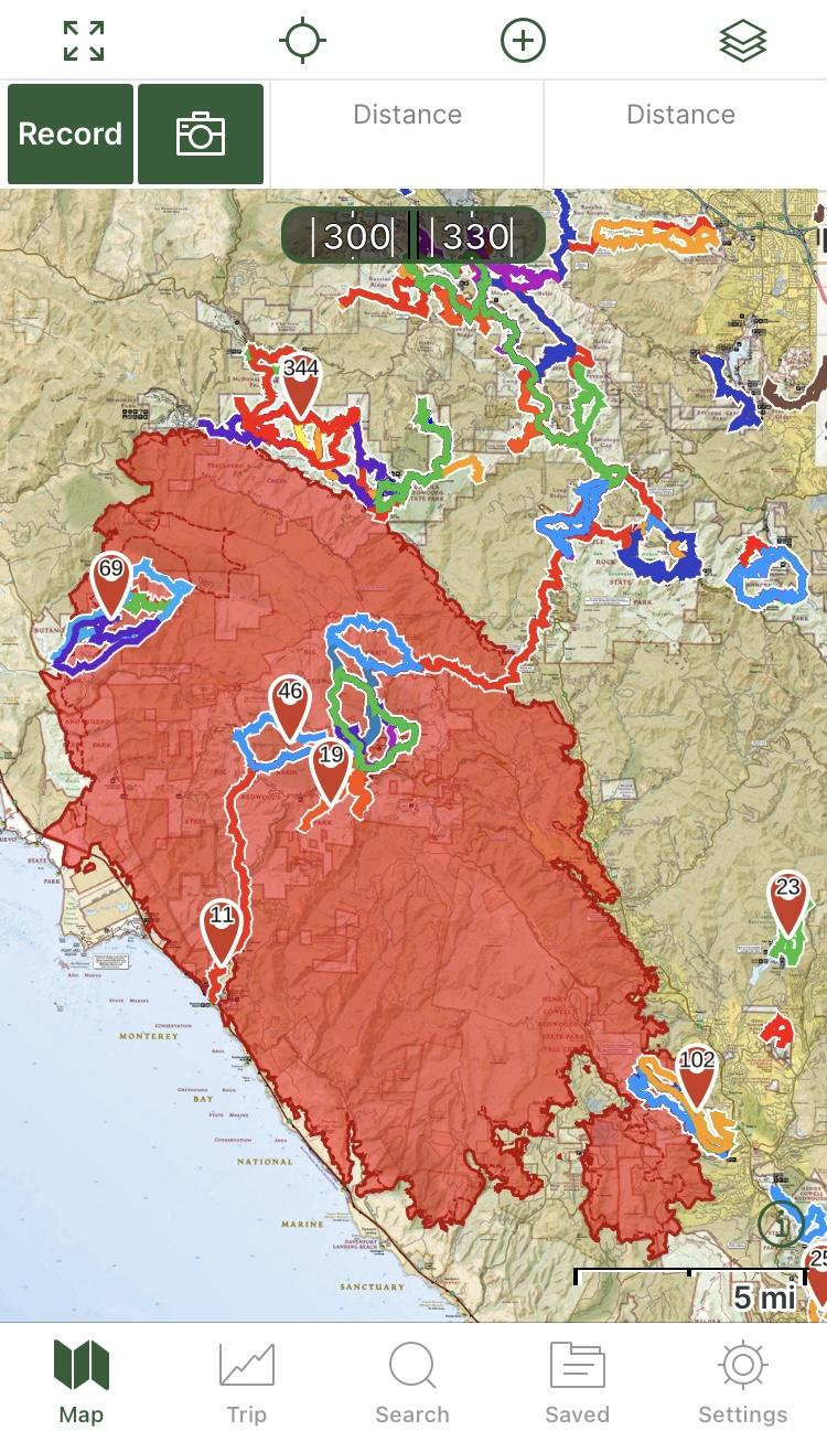
Ironic reading this just below a Gaia screen shot showing the 2020 burn area in Big Basin Redwoods State Park. Virtually the same area burned more than 100 years ago. Many people predicted the park would be forever changed. Instead, it quickly recovered.
But for Gaia to show (newer) historical burns without context could be misleading or deadly.
Many areas burned this year that burned quite recently. Some wildfires are more destructive than others. And most burns, including this year’s wildfire in Big Basin (aka the CZU Lightning Complex Fires), leave a mosaic of untouched, partially damaged, and totally destroyed patches. Expecting an active fire to stop or slow significantly when it hits a historical burn isn’t always a good bet.
If a wildfire is racing toward you, evacuate now. Don’t bet your life on Gaia’s historical burns, rivers, roads, lakes, or firefighters stopping it.
— Rex
PS – Some good news – long-planned controlled burns adjacent to the CZU Lightning Complex Fire filled the coastal skies with smoke over the last couple of days. A bit un-nerving to watch, triggered several 911 calls.
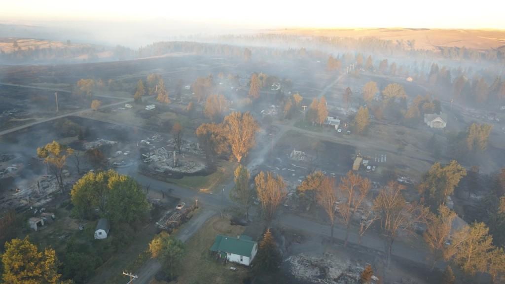
The Malden fire in WA state burned the whole town. It was in the middle of the Palouse wheat fields. High wind moved the fire thru the wheat and into the town.
Some idiot at the hardware store said Trump was right and we should have logged there to prevent the town from burning. I guess he meant cutting down the trees in peoples yards. The fire was started by a power line. Looks like even when you can get cheap power from the mighty dams, electrical blackouts may be needed to prevent fires. Or maybe the power companies can protect the lines.
“Danner says he wants to explore the possibility of power cutoffs but calls it a difficult issue.
“There’s going to be businesses shut down, and cell towers that don’t work. There’s going to be kidney dialysis machines turned off … And at the same time, if you don’t do that, you might end up with a Malden,” he said.”
“Controlled burn” is so 1970’s.
Some get out of control and burn more than they should. The correct term is “prescribed fire“
From part II
“Don’t be surprised if some land managers require backpackers to carry a shovel. They’ve forced whitewater rafters to carry those tools for decades, to put out “escaped campfires.”
Back in the day the US Forest Service could and would conscript you for fire fighting if you were present near a fire.They still have a requirement on the books that each vehicle or group needs to bring a shovel, axe, and bucket. It is no longer enforced it seems. I remember getting checked by a USFS employee before our scout group could head out on a backpack trip. It bugged me to have the axe handle standing proud high above the otherwise tidy canvas bag of my frame pack.
BLM requires a shovel of certain size and a bucket for OHV’s.
Montana Forest lands require a shovel and bucket for any campfires during fire season.
“Controlled burn” still used by Cal Fire for communicating with the public:

When you are lucky to get a 5 second quote on the evening news, you don’t have time to explain a “prescribed fire” to calm the jumpy nerves of a region that’s still recovering from many major blazes.
— Rex
I guess it depends on the audience. When trying to sell one to locals they don’t want to over promise.
A similar thing is life preservers VS personal flotation devices.
More than six months after the fire started, Big Basin is still burning
“A six-month fire may now seem logical to scientists, but it certainly didn’t before the turn of the century. Fire researcher Anthony Westerling found that from 1973 to 1982, fires burned for an average of six days, and from 2003 to 2012, they burned for an average of 52 days. As of today [March 4, 2021], the CZU Lightning Complex fires [in California] have been burning for 200 days.”
Astounding numbers, but not even close to a record:
“Although it started in 1904, the Big Basin fire continued smoldering for more than 14 months, reigniting the famous Chimney Tree in both May and November 1905.”
It’s increasingly obvious that the wildfire behavior we became accustomed to in the 20th century was far from normal – or sustainable, for many reasons.
Be safe out there.
— Rex
Become a member to post in the forums.
 Air-Permeable Fleece HoodieLightweight fleece hoodie weighing just 5.2 ounces.
 Loading...