


I was wondering if anyone had some web links or trip report information for backpacking in the Grand Canyon? Thanks,
Topic
Become a member to post in the forums.
I was wondering if anyone had some web links or trip report information for backpacking in the Grand Canyon? Thanks,
Dave,
There are to many to list….
Some general sense of you have in mind would help – distance, days, Phantom Ranch or not, first time trip, off the beaten track, spring or fall, single or group size, able to plan months in advance or just passing by, casual or epic, etc.
Greg – just starting my research for possibly a spring trip. Living in the Great White North, I am reasonably (highly) unfamiliar with the area. I did a Trans Zion Park Trek a couple of years ago and loved the topography but the Grand Canyon kicks it up several notches to be sure.
Where should one begin his research? Thanks!
…

http://hikearizona.com/traildex.php?SHOW=YES&ID=34&SUB_ID=24&NID=7&STx=3
There are lots of trip reports and trail descriptions on HAZ. Good place to start.

Also note that highway 89 south of Page is closed due to a landslide last year and to access the north rim and farther south to Flagstaff by car one can drive the alternate route (alt 89) toward Jacob Lake from the north (Kanab) and south (Flagstaff) directions now. Goes by Vermillion Cliffs. And there is another alternate to Page should you need to go there from the south at The Gap (44). Very scenic and no problem but this is a longer time consuming drive, just thought you should know for planning purposes or should you need medical attention. The south rim is no problem from Flagstaff as far as I know now.
You know what they say … timing is everything. I've spent the bulk of my time below the rim in the backcountry off the North Rim, but much of that area may be closed in the spring. (I have also been to all the tourist areas (North and South Rims).
For planning purposes, keep in mind that the official highway to the North Rim is usually closed until some time in May — but there are often "back road" ways around this, using dirt forest service roads (may need a 4WD, depending on snow/mud conditions).
I'll echo what another poster said — if you give us more details about what you're looking for, we'll be able to make MUCH better recommendations, for example, are you looking for:
-easy/moderate/hard trip;
-ok with crowds vs. want to get away from everyone;
-length of trip; particular interests like archeology, etc.;
-technical skills like rapelling, etc.;
-solo or group trip;
-etc.
Edited to add:
The section of AZ89 that washed out has now been fully re-routed and all roads are open (see http://www.azdot.gov/media/News/news-release/2013/10/15/newly-completed-us-89-bypass-fully-open-with-no-restrictions).

http://toddshikingguide.com/Hikes/Arizona/GrandCanyon/Canyon0.htm
Most trusted online info in my book.
Planning will really come down to ambition, experience, to what extent you want to avoid crowds, and when exactly you're going.
I strongly recommend that folks base off the North Rim if possible, because the main South Rim complex is such a junkshow. However access to North Rim THs is problematic in early spring. By late March most of the THs west of the Kaibab Plateau are reachable.
The Grand Canyon is rightly feared by backpackers. It's not just that water can be hard to find and the size of the climbs and descents, its how rocky and hardpacked those descents usually are.
If you're looking at popular permit areas for a trip in the spring you need to send in your applications now. April openings are being spoken for as we type.

The corridor trails (South Kaibab, North Kaibab, and Bright Angel) are generally scoffed at by us serious GC hikers . . . but my first trip was a corridor trip and I really enjoyed it at the time. One option that I've never done is to book the North Rim yurt. Or, for that matter, gone up the North Kaibab at all in the winter or spring.
The classic "second GC backpack" is the Hermit Loop, which I still haven't done. It has relatively frequent water sources and far fewer people than the corridor trails. One of these days I'll get around to hiking it!
As others have said, there's a wealth of routes there. You'll have to narrow things down a bit. Add in all the off-trail options, throw in ropes and packrafts, and there's a couple of lifetime's worth of exploring to be done. There's a reason I'm spending more than 30 nights there this year!
I second the recommendation of Todd Martin – one of the best guidebook writers out there.
Wow. Thanks for all of the info and links.
Valerie – not entirely sure yet as to what type of trip yet but the information and links provided to me will certainly get me started. I expect to have more definitive options (narrowed down as recommended) in a couple of weeks and will report back looking for more help.
As Dave C. mentioned, permits are being filled for April. May will be pretty hot for an in-canyon hike. March is "spring break" month – there won't be much left. So if you are considering April, decide fast. If you are thinking September/October, you have time.
To answer your original question:
A very good all-around website for GC hiking, planning, etc. I believe the original author is a former ranger:
http://www.hitthetrail.com/
Bob Riboka's GC hike reports – about as complete a set of hike reports as you'll find with realistic expectations for relative newbies:
http://www.kaibab.org/kaibab.org/show_reports.php
Jamie Campos' terrific website – just be aware that he does entire multi-day backpacking routes in an afternoon…
http://elveschasm.com/
I would recommend including the Hermit trail in your planning. It is less traveled than the corridor trails, has water sources, and is beautiful. Others are correct when they say the corridor permits go very fast. Grand Canyon is one of my all time favorite hikes…..esp after I did a rim to river and back..on the Hermit.
I did the Escalante Route three years ago and was absolutely blown away. It took four days to complete, though I'd recommend doing it in five if you have more time.
It's off-the-beaten-path, has less water sources but we were able to pump water from the River after letting it sit overnight (though it ruined the water pump filter after two uses, small price to pay for such a beautiful hike), and has a scramble up some rocks that might make those afraid of heights a little squeamish. Other than that, the scenery was top notch

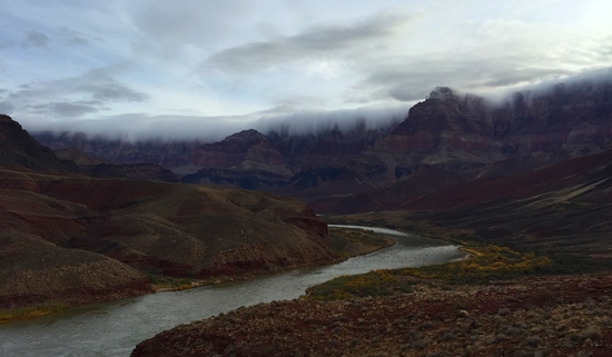
From the Escalante Route about 10 days ago:
.
.
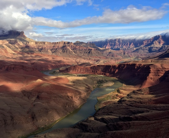
I love the cloud cover in that second photo.
I also hiked the Escalante Route last year in April over 5 days. I posted photos here: Escalante Route on Flickr
Make sure you zoom in on some of them.
Become a member to post in the forums.
 New Ultralight GearSee the latest releases in ultralight cottage-brand gear from small makers.
 © Beartooth Media Group Inc.
 Loading...