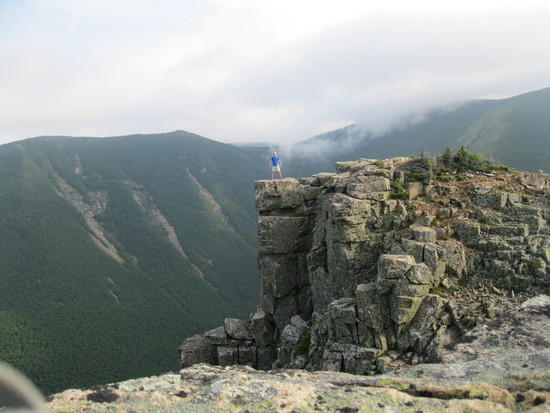
Well I finished the pemi loop in the White Mountains of New Hampshire. Here's the good, the bad and the ugly. In short, I felt under-prepared. It was a solo trip of roughly 33 miles and quite a bit of elevation change, but I knew all that going into it. I even knew that the temperature would be dropping down to the teens (-2 with wind chill) at least one night. What I did not know (and should have done more research on) was that the so-called "trail" was more like hiking over a combination of a 33 mile waterfall/creek bed. There was no real "trail" to speak of. Just lots and lots of rocks and boulders that kicked my butt. Over all, it was very rewarding and tough hike and I made it through with no real issues and a lot more humility by the end.
Saturday – Brief stop at the local grocery store then hit the trail by 6:30 pm. Hiked about 5 miles in and camped on bondcliff trail at 8 pm. No biggie.
Sunday – Started at 6:30 am the long slog up the remainder of Bondcliff Trail. What's up with all these rocks? Hopefully they will end soon. They didn't. At Bondcliff, I nearly got blown off the ridge by 50 mph winds. That was pretty scary and I hadn't experienced anything like that before. I made it to Mt. Bond, skipped West Bond and the Mt Guyot by noon. Making decent time until I left Guyot. The rocks attacked me as I descended and added insult to injury with black ice and 1/2 inch of snow. Finally made it to Garfield Ridge Campsite where I had to scale a waterfall (yes really) before I get to my resting place for the night (thankfully there was a hut I could use). Pretty warm until midnight and the wind picked up and the temp dropped down into the teens. My 30 degree quilt was no match!
Monday – Snoozed off and on doing occasional crunches to stay warm in the wee hours of Monday morning. Finally got up around 6 but had a number of technical issues (frozen socks, frozen water, frozen water filter). Didn't actually hit the trail until 8:30. Moved up to Mt. Garfield by 9 – breathtaking views and the trail was actually getting easier (or I was losing touch with reality). Lafayette by 1 pm – "The Agonies" were not as bad as I thought they would be and I actually found them easier than the path between Guyot and Garfield. Mt Lincoln by 2, slowing down, taking in the views and talking to tourists. There were a lot of folks in this area for a day hike. Passed through Little Haystack around 3:30-4 (a lot of ice in the downhill) and then Mt Liberty around 5 pm. I was really dragging at this point and my hopes of getting to the car by 8 were fading. Finished Mt. Flume by abut 6:30 and thought "I am ready to lay down here for the night." I motivated myself with the temptation of a PapaJohn's Hawaiian Pizza and got going. I stumbled through the remaining ~6 miles and made it to the car by 9 pm. Stick a fork in me – I'm done.
What went well:
* Some good tips from JakeDatc really helped out – bridge crossings, routes, suggestions and other cautionary tails.
* High winds on Bondcliff were no match for the Marmot Ether DriClime hoody. That thing is fantastic. The REI Mistral pants worked well for warmth, rain and wind but disappointed they didn't have a built in adjustable waist strap. They kept falling down as I dropped pounds on the trail.
* Face mask and mittens were a must. I added the on a whim at the last minute and can't imagine having finished some of those peaks without them.
* MotionX-GPS – A fantastic app that kept me on track, on the trail and allowed me to measure my distances and speeds as well as follow an imported track from JakeDatc. Highly recommended if you're going to bring your phone anyways.
What went wrong
* I didn't do enough research on the trail itself. If I had, I would known about the boulders and rocks that make up most of the trail and would have worn different shoes. I typically wear trail runners (in this case Merrell Proterras) and they were hands down the wrong shoe. Not enough ankle support and soles were too thin. My feet are regretting it.
* My sleep system didn't fail completely, but I wasn't exactly warm. Main issue was I was sleeping on a cold wood floor with a 1/2 thermarest pad. Trying to go "stupid light" when I knew in advance that temps would be down in the teens. I should have brought my Thermarest Neo-Air Xtherm and I would have stayed toasty.
* This was a complicated route in the best of conditions. What made it harder was I had to deal with black ice and 1/2 inch of snow and the constant reminders of one misstep would send me down the side of the mountain to be thawed out later in the spring. In short, it was physically exhausting and mentally taxing. I couldn't take my concentration off my feet until I started descending Flume.
Anyways, just thought I would report out on what I found. And here is a link to the pics I took. Some are decent, even if they were taken with an iPhone.
https://www.icloud.com/photostream/#A1Grq0zwGHLNcl;6CFD72B7-F7FA-4E51-A47C-D63E3A455681
-Chris