Topic

Cherry Creek Canyon, and off-trail explorations in general within reach of the SF Bay Area

  • This topic is empty.
Viewing 17 posts - 1 through 17 (of 17 total)
Rebecca 510 BPL Member
PostedSep 24, 2014 at 2:55 pm

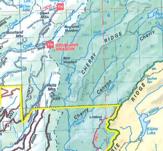
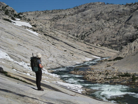
A couple weeks ago, I spent four days in Emigrant and followed the West Fork from the Pine Valley Trail (Louse Canyon) down to just past the outflow from Bear Meadow. Stunning granite and fun rock scrambling! While there, I met a local woman on a day hike who said it wasn't too hard to get into the West Fork from the Bourland trailhead, and I'm interested in returning by that route (which would be short and would hit the West Fork well downstream of Louse Canyon), following the West Fork farther downstream, and turning the corner to head upstream into Cherry Creek Canyon (main fork).

Most of this will be new territory for me. I've done quite a bit of off-trail route finding and am good at it, but it's a new adventure every time, and I'm looking for partners in exploration and improvisation–not offering to "lead" a trip with a well-defined plan. If you have fun looking back and forth between a map and a ridgeline and saying, "I think we could get there if we go above that dark rock and then to the right of those trees…" we'd probably get along.

I'm a capable hiker but generally not a high-speed, high-mileage one since I tend to like to stop and admire a things along the way (not just the summit view, but the little cascades, the granite basins, the flowers and frogs) and to scramble up random rocks just because the're there.

Apart from the Cherry Creek idea, I'm generally interested in meeting more people who enjoy that sort of travel, who seek out the places with no names and the routes that you create as you go. Ideally, folks who live in/near the bay area 'cause it's great to carpool. (I'm in the east bay.) I don't know many local off-trail hikers, and it's good to have companions when navigating rugged terrain on an un-planned route with no communication. Drop me a line if this sounds like your style!

Morgan Rucks BPL Member
PostedSep 25, 2014 at 10:05 am

Sounds good. Cherry creek is a cool spot. Lets try and get up there before the snow flies.

Justin Baker BPL Member
PostedSep 25, 2014 at 11:15 am

Morgan and I did some off trail stuff in Emigrant earlier this year. There are a bunch of off trail lakes to explore between Louise canyon and the north fork.

http://www.backpackinglight.com/cgi-bin/backpackinglight/forums/thread_display.html?forum_thread_id=91615

If you are really passionate about off trail hiking, there is a ton of stuff to do in Big Sur. It's a great place to go when the snow has fallen up in the Sierras. Most of the Big Sur routes involve walking along or in creeks (with plenty of wading or even swimming at times) at the bottom of canyons and/or bushwhacking along ridges. It can get a bit rough at times but it's worth it.

This trip was up to a place called "The Window" in the Ventana Wilderness.
http://imgur.com/a/ult6z/all

A good easy trip is to walk down to ventana, barlow or sykes camp and just follow the big sur river upstream or downstream and see where it takes you.

Rebecca 510 BPL Member
PostedSep 26, 2014 at 1:27 am

Hi Morgan and Justin! Your trip report looks awesome. I've tried a couple times to plan trips to the Hyatt/Rosasco Lakes area, derailed once by people flaking out and once by an unseasonably early outbreak of spring mosquitoes that sent us to higher elevations.

So funny that you met Alex from the Boomer Backpackers–I just started corresponding with him yesterday! I ran across one of his trips when I was googling about getting from Bourland down to the West Fork, and wrote to ask him about the route. Doesn't sound too hard. I'd love to get out there before snow flies this year. The West Fork was just perfect for walking when I went this month–little enough water to admire the forms of the eroded channel and often use it as a path, but enough deep pools remaining that drinking water was never a problem (the pools looked brown, but the brown stuff was all sitting on the bottom–scoop some from the top, and it's clean and clear).

That's a great tip about Big Sur. I haven't explored that area, and I'd love to have some more adventures when the Sierras are snowed under. Is the poison oak bad? That's one thing that makes me hesitate over bushwhacking in the bay area; I've gotten a couple nasty cases when I've been forced to barge through it for work, and I wouldn't really choose to do that if I'm not getting paid. I do love rock-hopping along creeks.

d k BPL Member
PostedSep 26, 2014 at 8:56 am

Is the poison oak bad in Big Sur?

Yep. Ticks are reasonably bad too, depending on time of year, but the poison oak is what keeps me away from there now, since I'm quite allergic to it.

Bob Gross BPL Member
PostedSep 26, 2014 at 12:48 pm

"Is the poison oak bad in Big Sur?"

In lots of places, yes.

Big Sur is always good for poison oak, ticks, and rattlesnakes.

–B.G.–

Rebecca 510 BPL Member
PostedSep 26, 2014 at 6:25 pm

I'm OK dealing with ticks and rattlesnakes. I saw a fair-sized rattlesnake down in the West Fork. Really not a fan of poison oak, but if I get stir-crazy this winter, I may be up for trying some Big Sur adventures anyhow and seeing if I can steer clear of the worst of it.

I've been doing my homework, and the junction of the West Fork and Main Fork may be just barely within the Rim Fire closure area. It's within on this low-detail map: https://www.dropbox.com/s/bwqovh49iprkinj/RimFireOrder_STF-2014-01.pdf I talked to a couple different rangers, and they didn't know specifics. They said that crews have marked out closure areas on the ground but that the rule is basically "if it looks burned, don't go there; if it doesn't look burned, go ahead."

It might be possible to cut the corner by crossing the shoulder of Cherry Ridge. There's a low point due east of Hells Mountain that looks promising on the map, about 500' above the west fork and 1100' above the main fork.

I won't be free for a long trip till after Oct 10th, but I'm thinking of going out next Saturday through Monday (4th-6th) for a scouting trip. Anyone interested in scouting with me?

Justin Baker BPL Member
PostedSep 26, 2014 at 7:01 pm

Along the streams you have large redwood trees which crowd out sunlight and really reduce the amount of poison oak. There is still some poison oak, but it's easily noticed and avoided.

When planning an off trail adventure there, the best way to travel is along the waterways. You use them as trails. That's how the area was first explored.
You generally want to avoid leaving the streams unless necessary because you will hit walls of brush that slow down travel. Once you hit the chaparral you get hit large bunches of poison oak, some of it placed conveniently at face level. Even on some of the "trails" the poison oak overgrows enough to be a real issue. Actually, you are more likely to get poison oak hiking on a trail (most of them are up on the ridges) than on a creek exploring trip.

You can plan fun trips there that never leave the creeks.

I'm lucky because I don't react to poison oak.

Alex is a cool guy. "In Soviet Russia, there was no baby. Only boom."

Bill Law BPL Member
PostedSep 26, 2014 at 8:01 pm

It looks like the confluence of West and Main forks Cherry Creek are *inside* the closure area. I wouldn't wager on running into a ranger there, however.

portion of Rim Fire closure area map

That's low enough elevation that you might get to enjoy poison oak and ticks without even having to go to Big Sur.

I do notice that the Bourland Mdw and Box Spring trailheads are on this section of the map.

I've thought about using one of those to get to Hyatt Lk and environs. But that's a maze of FS roads in there. Has anybody been to those trailheads and can you give some directions? I wouldn't even know where to turn off the highway (or which highway; 108 near Long Barn?). Are there signs posted at the key junctions (as at Crabree and Gianelli)?

Note that the roads that approach nearest to Hells Mtn are closed. Maybe those "official" THs are inaccessible now, also?

Rebecca 510 BPL Member
PostedSep 26, 2014 at 8:19 pm

Rangers have confirmed that Bourland Trailhead is open. I think the only Emigrant trailhead that's closed is Shingle Springs.

I haven't been out to Bourland yet. Friends who have gone have told me that Bourland and Box Springs are both much less developed than, say, Crabtree; they might both just be dead ends with a bit of gravel you can park in. I'll try to get in touch with those friends before heading out there to ask about navigating the maze.

That line on the map is so clearly just drawn along a section line, I don't think the fire did that! But yeah, good chance the fire did just barely catch the junction I'm interested in. I don't know that I'd worry about it if it's all open granite. If it turns out to be burned forest, there could be some real hazards.

Rebecca 510 BPL Member
PostedOct 8, 2014 at 4:56 pm

It was a wonderful weekend, and we did turn the corner from the West Fork and head up Cherry Creek as far as the junction with the first significant unnamed stream (the one that runs just at the base of Cherry Ridge for a couple miles). The confluence isn't burned. On the way up Cherry Creek, we found a few stray half-burned trees, but in such tiny clumps (among unburned trees) that I doubt they were from the Rim Fire.

Water was good, weather was good, canyons were amazing! Definitely want to return and explore farther upstream.

Bill Law BPL Member
PostedOct 8, 2014 at 5:35 pm

Sounds like fun.

Was there water flowing in the main fork Cherry Creek? If so, any signs of fish?

Which trailhead did you use? Any advice on getting to it? I'm assuming it wasn't the usual ones (Crabtree, or even Bell Meadow).

Sorry for so many questions…

Rebecca 510 BPL Member
PostedOct 11, 2014 at 9:07 am

Yes, there was a little flowing water in the main fork, and plenty of pools. By the time we turned the corner at the confluence, it was getting late in the day, and we didn't hang around by any of the pools long enough to notice whether there were fish.

We used the Bourland trailhead. It's about an our from Hwy 108 to the trailhead, which is just a dead-end dirt road with no amenities. The forest service directions got us there OK; I'll copy them in at the end of this post. I also took Google directions, but they were wrong (they mentioned a road in between 3N01 and 3N16 that didn't seem to exist).

One spot that's a little confusing is very close to the the beginning–you come to a funky-shaped intersection with street signs that say North Fork Rd and Merrill Springs (and nothing indicating 3N01). Bear left there.

As for the beginning of the hike, follow the closed part of the dirt road till it turns into a use trail, which you'll call a good one if you're used to vague little use trails or confusing and hard to follow if you're used to maintained trails (I've heard it described both ways), and follow that till it dead ends in open granite. Then scramble down the granite into the West Fork.


Bourland Meadow (Primitive Trail)
Elevation 7,080’, native surface, limited parking, fair overnight
camping opportunities, no facilities.
From Summit Ranger District (Pinecrest)
take Hwy 108
west 10 1/2 miles, turn left into Long Barn. Continue 1/4 mile
and take a left turn on road 3N01. Continue 20.3 miles, turn left
on 3N16. Follow road 1/4 mile past 3N20Y Jct. Road dead
ends at parking area.

From Mi-Wok Ranger District
take Hwy 108 east 5 miles to
the second Long Barn exit, turning right into Long Barn.
Continue 1/4 mile, taking the second left on 3N01. Continue
20.3 miles to road 3N16, turning left. Follow road 1/4 mile past
3N20Y Jct. Road dead ends at parking area

PostedOct 11, 2014 at 12:29 pm

Rebecca, glad you had a good time on Cherry. That canyon is a hidden gem. My wife and I did the full descent from Lord Meadow all the way to the lake a few years ago. I've been meaning to go back. I think the best section is from the Hyatt outflow to Cherry Bomb Gorge, but it's all great.

1

There's a contingent of us from the Bay Area that go on trips together pretty often, and it generally ends up involving some portion of off-trail. It's mostly dudes, but my wife and a few girlfriends come along sometimes.

Bill, sadly the fishing on Cherry sucks. I went with a friend of mine who's an excellent flyfisherman and we caught exactly nothing. I think the fact that the creek bottom is scoured granite for miles and miles around there leads to poor feeding opportunities, and that whole canyon gets seriously flushed in the spring with huge amounts of runoff.

Rebecca 510 BPL Member
PostedOct 14, 2014 at 1:12 am

Nice photo, Andrew!

Where exactly is Cherry Bomb Gorge? I've run across the name any number of times but never seen it identified on a map or in relation to any features.

I get along fine with dudes. I've never felt any need for my travel buddies to be from any particular demographic. Actually, I've finally got a plan for a longer Cherry Creek trip worked out with a guy friend–fingers crossed for the good weather to last!

Rebecca 510 BPL Member
PostedOct 15, 2014 at 10:23 am

Ahh, that's the bit I was just starting to see off in the distance on the last trip that I so wished I had time to hike to!

Thanks for the invitation! Hmm, it'd be an awfully quick turn-around after the Cherry Creek trip, but I could probably manage it…

Viewing 17 posts - 1 through 17 (of 17 total)
Loading...