Wednesday July 29 8:30pm—Sunday August 3 1:40pm
Castle Danger to Lutsen
tl;dr: SHT is great. Long days on weak feet requires tape. I still have a few things to learn.
In the last month-plus of marriage, honeymooning, and settling into the lazy domestic routine of a teacher in the summer, I had started to grow a bit restless. It’s the sort of restlessness that sticks even through housekeeping chores, organizing for the upcoming school year, social visits with friends, Netflix, and halfhearted attempts to get back into running. So last week my wife said, point blank, “You should go on a trip. You’ll be frustrated if you don’t. Go straight from visiting your mom and don’t come back until Sunday.”
Lovely!
I quickly settled on the Superior Hiking Trail, due to its multitude of access points, available drinking water, and my childhood trips to Tettegouche State Park. I planned the trip outward in each direction from Tettegouche, using the Guide to the Superior Hiking Trail put out by the SHT Association. My brother gave me the book after he finished thru-hiking the trail in 2009; there are newer versions available but from what I can tell old copies should still suffice if you find one at your library/Amazon.
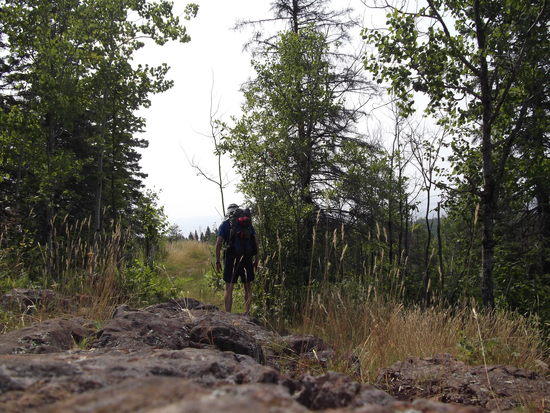
Because I was hiking alone I decided to base the trip around mileage. There are just so many things to see along the north shore that I wanted to cram in as much as possible in the time I had. Not including the 1.3 miles I walked the first night, I traveled approximately 35, 27, 30, and 20 miles on each day. For the most part, and as I would find out firsthand, this trail is not like the trails whose pictures grace the full-page glamor shots in Backpacker. Very few sections have an even, 18-inch gravel tread. Most of the trail is rocks, or is mud, or is roots, or is grass, or some mix of these with occasional respite by way of a boardwalk. The miles I walked took quite a toll on my feet, and I used most of the daylight hours traveling. For a social trip with some camp time I would set a maximum of 15-20 miles on the SHT per day, unless the whole group likes to set out of camp at sunrise.
Below are some daily highlights, as well as some gear notes and notes-to-self/skills to develop.
Wednesday night I drove up from Mankato, on the road at 3pm. My enthusiasm was tempered by Twin Cities traffic, which added an hour. Arriving at the trailhead at 8:30pm, I knew I had just enough time to hike in 1.3 miles to the first campsite on the trail. My original plan to camp at the trailhead had been rendered unnecessary, since a sign was posted strictly prohibiting camping there or sleeping in cars.
In the fading light I walked the trail, passing a couple who had also driven up that evening, making their way with big Kelty internal-frame packs. Arriving at camp, I set up my shelter and bear bag, and was getting ready for bed when they rolled into the site to set up in the dark. A Juilliard-trained owl provided some evening entertainment.
Thursday morning I awoke as the sky and forest around me turned blue-gray, and I tried to strike camp and make oatmeal and coffee as quietly as I could. The couple in their tent slept as I departed camp around 6:30.
The section up to the Gooseberry River was defined by lots of rocks, some mud, and several minor overlooks. The trail eventually comes to and follows the fairly calm brown-red river past a few hiker campsites within the state park. I saw a few campers stirring, and one pair of 30-something men hiking the opposite direction.
From Gooseberry to Split Rock State Park the morning’s condensation was heavy and persistent, and the moisture made itself known as the overgrown meadow grasses soaked my legs and feet. This was a beautiful section of high meadow, brush, and sumac hillsides. My simultaneous love of morning meadow hiking through the heathers and dislike of said heathers wetting my feet led me to come up with a very inappropriate “Hey Bear!” call and response. The trail continued up a gorgeous ridgeline meadow called Bread Loaf, and lived up to its alternative namesake of “blueberry hill.” Countless prairie flower species, lichens, mosses, and shrubs lived on this giant slab of rock, with dramatic views available regularly.
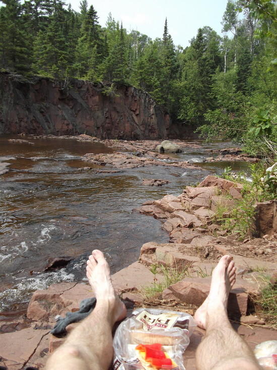
Entering Split Rock River gorge, the trail went upstream on a very rocky path just over the river. In terms of intimate scenery, this was perhaps in the top two rivers of the whole trip. Around noon I took a dip in one of the pools across from a red cliff, drying off while munching on pita bread, cheddar, and a fresh red bell pepper.
After lunch I followed the trail farther upstream to a bridge and then back downstream on the higher ridge of the opposite bank. A more birds-eye view of the path already taken prepared me for another gradual ascent out of the valley and onto another series of meadow-on-rock escarpments overlooking Lake Superior, down to an access road, and up again on a long ramp to another, less dramatic ridgeline. The views are less long, but walking an extended, narrow plateau boxed in by pines, alternating deciduous forest with meadow, was a great way to keep my mind occupied as the day’s miles wore on. Just before a beaver pond I passed an extremely healthy-looking doe about 20 yards off trail.
In trying to cut weight I wound up running a little low on water, and so the blueberry patches at the far end of the ridge slowed me down a bit. I actually missed a turn in the trail following a user/game trail into the berries, and had to backtrack a minute once I realized what I had done. At that point I knew I would probably make it just to the Beaver River campsites, my “minimum” goal for the day.
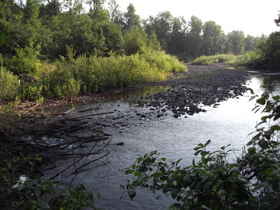
Coming down off the ridge I was in turn greeted by a road crossing, taconite ponds, road walk, rail crossing, bridge, and finally the Beaver River. Cool, brown, and inviting, I walked quickly past the first campsite to refill on water and soak my legs.
Rejuvenated, I decided just after 6pm that I could make another five and a half miles to my next camping option. For future reference, one of the Beaver River sites is adjacent to the top of a rocky cascade and I would heartily recommend it. Looking longingly over my shoulder at the tent set up there already, I felt a bit of end-of-day adrenaline kick in and I set off for another couple hours of walking.
The final section of the day into Penn Creek was an interesting blend of orange sunlight on rocky bluff summits, with a lot of ups and downs serving as a bit of a peek-a-boo with parts of neighboring Silver Bay. I made it into camp, set up my “quantum of solace” cheapo bug net and hung a line for the bear bag. I cooked my couscous and fresh chickpeas within the net to avoid the local swarm, then quickly went out to hoist the bag and returned.
Not setting an alarm again, I awoke about 7am Friday to quickly pack up, get water from Penn Creek’s trickle of a waterfall at the end of a 20-foot rock “hallway,” and got back onto the main trail. Shortly reaching the top of a huge overlook over Bean Lake, I broke out the coffee and granola to watch a cow moose and her two young’uns swim the length of the lake far below.
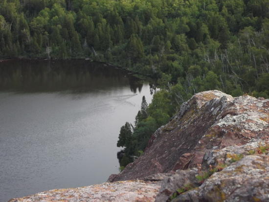
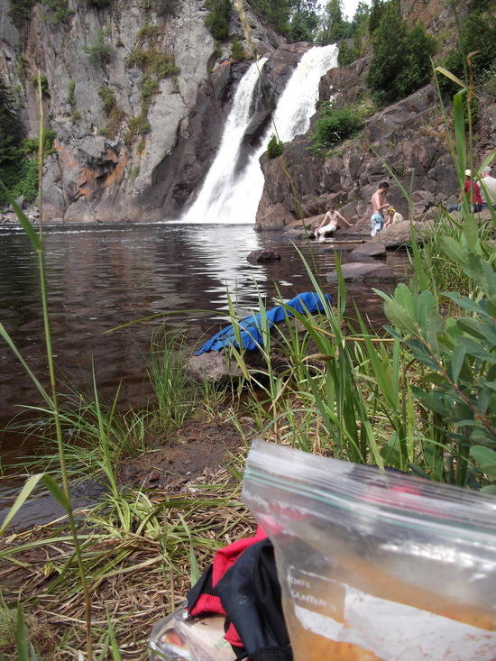
The ridge above Bean and Bear Lakes in Tettegouche has some of the most excellent scenery of the whole trip, and with the morning light making the red rock glow I passed the Bear Lake site located on the east end of the lake under a tall cliff and talus field, another one I would strongly recommend. Through some more ups and downs I stayed on the same ridge system, at each overlook and “mountain” being able to look back at where I had already been. After a more plain stretch of trail, and some connector trails with wide, state-park-style gravel tread, I reached High Falls, where the trail bridge crosses a the top and a spur goes to the bottom, where I swam briefly in the chilly Baptism River and had a snack. There were plenty of other day-use visitors here.
The next section from Highway 1 to Lake County Road 6 flew by, past Fantasia Overlook, through the Wolf Ridge Environmental Learning Center, and a mix of forest and blufftop hiking. It was a very good topographical blend, enough to keep interest. I stopped atop Sawmill Dome to have my lunch, dry salami and pita, before heading thirty seconds down the trail to find the spot on the map labeled “Picnic Rock” just under the treed-in summit where I had eaten. From here I could clearly see quite a bit of the upcoming Section 13.
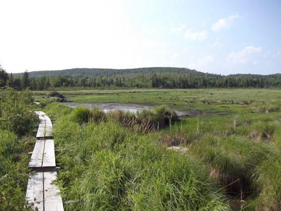
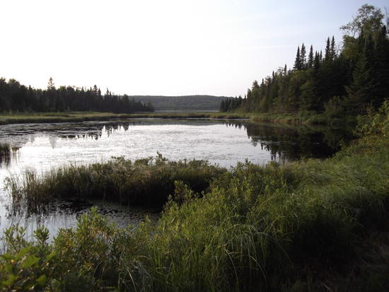
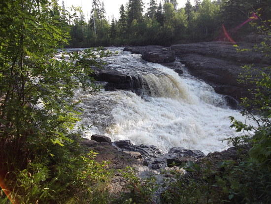
Crossing the road and moving through yet another trailhead, I climbed and descended several times among a giant rock garden (Section 13 is popular with climbers and has a dry campsite among the outcrops). Thereafter the walking got a bit more tedious, moving through a more wet and root-strewn lowland. I was getting tired by this point in the day, and had to verbally berate a couple of roots that my toes disagreed with. A couple sections of boardwalk sped things up, including a long one around a beaver pond with wide-open views (below). I was happy when I descended to the East Branch of the Baptism River, where I got my last water for the day, had some trail mix, and wet my bandana. I was nearly into the next section and two miles from my goal of Egge Lake.
It was during this last two-mile stretch that I caught myself looking at my watch too often. To be sure, timing was becoming more important as the sun got lower, but the watch wasn’t giving me any news of my progress in the forest, where I could see perhaps up to 30 seconds in front of me at a stretch. Instead, I made a game of cruising at an even clip over minor ups and downs, only “counting” hills or obstacles that made me slow down. I could just draw a number, I think it was eight, and tell myself that I would only check my watch when I reached that number.
The sky was golden as I came to the south end of Egge Lake…
…and I continued down around its outlet and back near its east shore, traveling to one of the campsites there to look around. I found an adult family of four; we talked about our respective comings and goings, and I got another late-day surge of adrenaline, saying, “Well, I do still have another hour until it’s dark.”
And so I moved on, through the rooted, muddy, rocky trail through the forest to the next site at Sonju Lake, 3.3 miles away. Thanks to the counting game, and getting lost in my thoughts for awhile, I made it in good spirits. I did feel an unfortunate twinge between my right shin and top of the ankle, so I was extra careful not to catch my feet. Arriving in camp, I resumed my previous night’s routine, setting up my bear rope and “quantum of solace” net in the last light. I cooked and ate ramen and cauliflower safe from the swarm before pulling up the bear bag.
I awoke that night around 2am to answer the call of nature, and refilled my water from the lake at that point as well. There is actually a small section of boardwalk from the site out onto the lake, and the bugs had all gone to bed, so I was able to take a few minutes to watch satellites on an exceptionally clear, still, cool night.
I did actually set an alarm for the morning, because I planned to push for a 40 miler if possible. I used a little KT tape to support my ankle, and a little more to affix a band-aid to the blister forming between the ball and big toe on my left foot. After oatmeal and coffee, I packed up and hit the trail with the first light at 5:20am. The roots and mud and rocks did get occasionally less troublesome, and hitting this section fresh rather than at the end of the day was much preferred mentally. I passed a few more campsites, one of which was notable as it was at the intersection of a creek and the East Branch Baptism River, on a narrow bit of land. That would be my choice site in area for the future.
Walking up a comparatively easy stretch of entrance road of Crosby-Manitou State Park belied what was to come in the park itself. This was perhaps the physically toughest part of the trip in terms of steep ups and downs. Besides the namesake river itself, the Manitou valley felt much like the rocky undulations I had been through before Tettegouche, but bigger and steeper. The reward was frequent changes of scenery, as I bounced through a beaver pond or forest one minute, scrambled up a boulder slope for a few minutes, traversed a small peak or ridge for a few seconds, and back down the other side. Rinse and repeat. The Horseshoe Ridge area was indeed tough, but I would definitely recommend the site up there just for the location.
The trail descended another hour to cross the Caribou River, inland from the popular State Wayside on a smaller bridge, beginning an eight mile section that the guidebook said was relatively easy and looked it on the map. Here I was not disappointed, as the trail gradually moved up into a long birch and wildflower covered ridgeline with glimpses of the big lake. Just ahead of Sugar Hill Road the cover changed to a small conifer grove, and the pine needles under my feet caused me to audibly sigh from the extra cushion. After this I moved back into alternating forest, meadow, creek, and beaver pond. “Alfred’s Pond” is a great little place, marked on the map and mentioned in the guidebook, but I think there are plenty of places along the trail quite similar.
Another hour or so brought me along the Two Island River and out of the section. I had planned to be to the Cross River campsites by 4pm so that I could wash up, brew coffee, and have some food at the 30 mile mark and still make 40 by sundown. `I fairly sailed through the first four miles of the next section, with the exception of a couple short steep climbs and several downed trees, arriving at the third of four campsites on the Cross at 3:55.
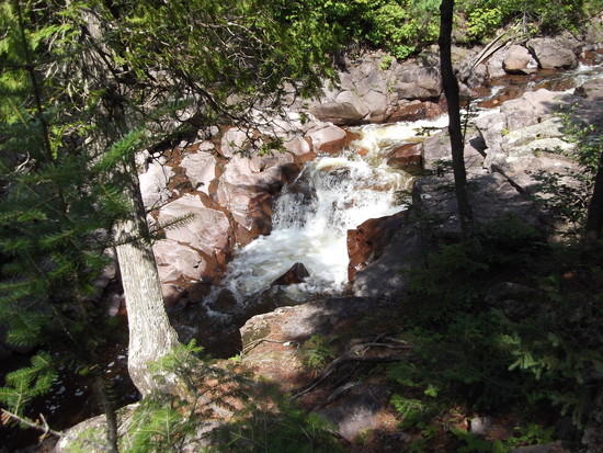
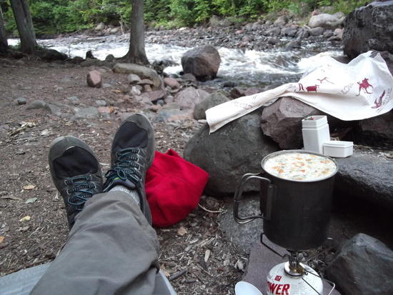
Pleased with myself, I took my pack down next to the river, took off my shoes, socks, and tape, and soaked my body in the current for a few minutes. Shortly thereafter I was enjoying coffee, salami on pita, and an apple on the riverbank. All was right in the world, and as I was fishing my guidebook and KT tape out of my pack to prepare for a final ten-mile push, I had a bit of an epiphany. I looked downstream, where the rushing water disappeared around a bend. Upstream, a series of small rapids terminated in a powerful waterfall plunging through a crack in the rock. Over my right shoulder was a fire pit six feet up the bank, and over my left were a few trees with just a few flat places between.
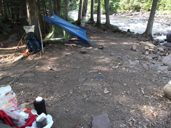
So I did get out the guidebook, but only to confirm that I would be absolutely fine staying here for the night. I donned my fat cushy socks, pants, and windshirt, lazily set up camp, and sat around on my RidgeRest to catch up on my journal and watch the water. This whole process was so freeing, it’s hard to describe. I would have pushed myself over a pretty major “Minnesota Mountain” or two, and would have felt accomplished, but there was no way I would get a site like this.
During what felt like an obscene amount of camp time, I had a few visitors drop in. Another solo hiker had come the opposite direction from near Grand Marais, setting his tent up across the trail and up from the river. He self-identified as a “notorious overpacker,” but he appeared to be fit and had been churning out 20 mile days in light hiking shoes, so more power to him. I also spoke with an Outward Bound leader camped one site away with his crew, who were on day 19 after spending time in the Boundary Waters and on the SHT. We were able to talk about our experiences guiding and differences and overlaps between lightweight hiking and institutionalized outdoor experiences. Later on a titanium-mug-in-reflectix-cozy-toting young gentleman came into my camp as well. He was hiking solo, but I actually didn’t see where he set up…presumably he was at a previous site, or was so ultralight that he only brought a ti mug and slept in caves. If I recall correctly, all three were getting picked up the next day at the park entrance less than three miles away.
My last encounter of the evening was with a mother who was camping with her two sons (or son and a friend). She set up her tent a bit close to where I had hung my bear rope earlier, so as a courtesy I went over to move my line. She asked me what it was, and what it was for, explaining that she wasn’t “much of a camper,” so I did my best to educate her kindly. In fairness, bears are not as much a threat here as they are in other places, but hikers have had bear encounters and had food taken on the SHT this season. I told her as much, and that she should at least get food out of the tent and off the ground away from squirrels and mice. In the morning I would see a small bag hanging about six feet from the ground between two trees; much better than nothing. I was mostly glad to see the two kids out, because such experiences were so foundational in my own childhood and because a lot of parents don’t even try to do that.
My thirty-mile day ended up feeling mentally like a layover day, and I was glad for the human interactions, relaxation, time to enjoy a truly full mug of white bean soup and a fire before bed.
On my last morning I had twenty miles to go to reach Lutsen (a ski resort) and my arranged shuttle at 2:05. Leaving camp at 6:20am after KT tape, coffee and granola, I cruised across and away from the Cross River, heading mostly uphill out of the valley and onto a grassy sidehill wet with dew. After descending a ways through a forest I emerged onto a Forest Service Road, crossing it to find the stunning Temperance River. I would very narrowly award this as the most scenic river valley on my trip, just ahead of Split Rock. The trail here does something very similar, going downstream along the river before crossing at a canyon cascade and doubling back for the same view upstream before eventually climbing out of the valley. I stopped at a river bend before the climb to change socks and take in the view.
From here the trail alternated flat and up, and then more up. I arrived at what I thought was the top of Carlton Peak, which was supposed to be really great, but I found it was treed-in, including a short overlook spur trail. Frustrated, I continued along the trail and before long looked up through the trees to see a massive rock formation above me. Ah, so that’s it. The view from the top was incredible, perhaps the longest view available that I saw. I changed socks again here and had a snack before continuing down off the summit and setting my pack down to follow a short spur for the Tofte Overlook. I was in a hurry and didn’t bring my camera up here, and I regret that. The view from Tofte is actually better than the summit itself, somehow.
The trail continued down to the Britton Peak parking lot, and from there it was five minutes until I was atop yet another peak, looking back at Carlton where I had just been. A bit less than six miles stood between me and the final section to Lutsen, and I marched through the somewhat plain forest after Britton and another overlook. The trail was noteworthy for being somewhat muddy, but mostly was dry enough to walk right through. I skipped Leveaux Mountain, since the two solo hikers I talked to the night before recommended the upcoming Oberg Mountain lookout loop much more strongly. By today I had gotten my pace up to an even 3 mph (from camp to camp, including any stops), and was happy to push it a bit to make my early afternoon shuttle.
The only major casualty of my fast-paced finish was in needing to skip Oberg Mountain’s views as well in order to have an acceptable margin to beat the shuttle. Oberg is very accessible from a road, and it gives me a reason to go back, anyway. Crossing under the spur trail to the lookout loop above, I saw three backpacks left at the junction and felt a bit wistful, but made the conservative choice to move on and come back when I had a bit more time. Had I pushed it the last night I would have been able to take my time finishing, but I made the right choice.
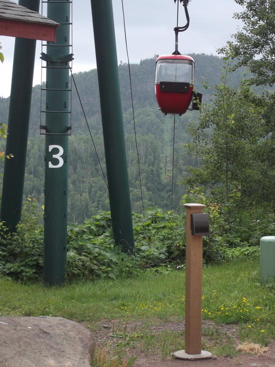
The last section moved past Oberg, over a creek, and up a steep climb to a ridge. From this point I saw three separate people over 60 either running or speed-walking the trail for fitness, all having a great time. I reached the end of the ridge, and moved quickly downhill and then soon back uphill again on switchbacks moving vaguely through the woods up to Mystery Mountain, my final high climb of the trip. I mistakenly recalled that there was a campsite 2.5 miles from the resort, and began to worry when it got to after 1pm and I hadn’t yet seen it. Approaching the site at 1:20, I hurriedly dug out the guidebook and, oh, I guess it’s only .9 miles. I relaxed down the hill, emerging into and crossing a bridge over the beautiful Poplar River gorge as the ski hill came into sight. The last few hundred yards are on a gravel road, walking toward the hill and watching red gondolas arrive and depart for sightseers—an almost anticlimactic but somehow fitting end to the trip, where I emerge from the northwoods forest into our best Minnesota version of a Colorado or Swiss resort.
A slightly late shuttle, change of clothes back in Castle Danger, ice cream in Two Harbors, greasy spoon breakfast-for-dinner and coffee in Moose Lake, and some public radio later, I was back home for a shower and sleep. Sitting upright for hours for the first time in days had a lot of blood pooling in my feet, and they formed a couple new blisters just on the car ride. A day later I found some minor swelling and sensitivity on the ankle, and I’m recovering nicely with some ice and down-time.
Gear and Other:
I really lucked out with a dry weather window. In wet weather I can see how trail mud would have an enormous impact on one’s progress. As it was I enjoyed just taking my cheap little blue sil tarp and $15 bug net.
My backpack, a Granite Gear Vapor Trail, was both good and bad. Sizing down to a small hipbelt would probably help the carry, though I don’t know if sizing up the torso to a large would get the frame high enough. It’s a bit of a fat pack for my taste anyway, so I used the “cloud” method and kept my RidgeRest inside away from my back. I don’t like trying to access a liter bottle from the side pockets, so I just kept mine on top of the pack under a strap or inside. The stretch side pockets were great for gorp, camera, and navigation stuff. I think I would like a better-fitting, lighter, closer, and less cushy pack, and this may be a MYOG project (or two, or…). I’m especially digging the current designs for running-vest-style shoulder harnesses to carry water and snacks, with a single-stay plus foam pad suspension, full-wrap light hipbelt, daisy chains, and a Patagonia Ascensionist top closure.
Because my trip came together somewhat last-minute, I bought a pair of Merrell trail runners just prior. It just so happened that just had some street running shoes and some overly well-worn trail shoes that had rubbed my heel raw previously. Yes, I got some blisters and a twinge in my ankle from the Merrells, but the fit was good, they were light and had enough padding and protection, and were grippy. I’m happy with the purchase, if not completely with the shoes. Lesson learned: have shoes available if you want to go on a trip! Fortunately KT tape really saved the day, and I will be sure to carry it in the future, adding in Second Skin or similar.
Although I love walking in old running shorts and shirt, I think I need to retire them both due to thinness, perma-stink, and limited wicking. The shorts resulted in a bit of pack chafe and the shirt really didn’t dry out that well, despite holding very little water once wrung out. I would really like to find some running shorts that didn’t smell bad—it’s almost like there’s a conspiracy to make people buy more shorts because they smell after one use (/sarc).
I have absolutely no complaints about my EE Prodigy 40, RidgeRest ¾, or GigaPower Stove. All are simple pieces that are difficult to misuse and have a minimum of faff. The stove could be lighter or not used at all, but it’s a quite safe way to cook in a high-clearance floorless bug net by headlamp without worry. I used Potable Aqua on the trip and I’m not dead yet (will update if that changes), but I’m considering a Sawyer Squeeze Mini for the future.
I would have liked an efficient way to wash clothes and body on trail, with soap. Next time I’ll plan to bring some Dr. Bronner’s and a gallon Ziploc for the purpose, or repurpose a bottle or pot. I was not fastidious enough about my hygiene and I think I would have felt better at the end of the day with at least a wipe-down with more than river water, given that I was sweating for double-digit hours each day.
I set an ambitious goal for the trip and reached it, but my conditioning could have been better. Even though being casually in shape with a high aerobic capability is great preparation for long walks, biking and street running leave out foot strength, skin toughness, and ability for joints and small muscles to handle repeated stress and uneven terrain in an itinerary such as mine. I guess that’s a good thing, since now I “need” to take more trips, in order to be prepared for more trips!
A final thing I should be doing is putting my geeking out about future trips onto paper. If I had done some more route calculations and put together more than just a simple itinerary page, I could have left the guidebook at home. I also could have afforded to look at both my watch and guidebook less, in order to be more “in the moment.” I think just carrying the pocket maps or making my own would put some more adventure back into a very accessible but rough and wild-feeling trail.