Topic

GPS maps: feeling really stupid

  • This topic is empty.
Viewing 8 posts - 1 through 8 (of 8 total)
Diane Pinkers BPL Member
PostedAug 3, 2014 at 8:44 pm

Is there a website that teaches one, in little bitty baby steps, how to build a GPS track? I'd like to make a path and elevation profile for an upcoming hike. I've played around a little on gmap4 and a couple other sites. GPS waypoints seem to want make straight line tracks, and paths curve and wander–is it unrealistic to expect waypoints to follow a trail exactly on a map?

Bob Gross BPL Member
PostedAug 3, 2014 at 9:05 pm

Civilian GPS receivers have a finite sampling rate. So, they make data points every second or every ten seconds or whatever as you move the receiver along a winding trail. If the trail is very winding, some of the data points will be in a good spot to represent the trail curves, but some of other data points will be lost in the curves. So, the slow sampling rate is working against you.

If you were trying to map a 10-mile section of winding trail, and if you and the receiver were really stupid, you might have it collect data points at only two spots, namely, the beginning and the end. That would give you the least accurate representation of the trail in the smallest file. On the other hand, if the receiver were capable of this, you might have it sampling every second. Over the course of five hours, this would produce 18,000 data points, and that might show all of the wiggles and bends in the trail.

For data manipulation and storage purposes, that might be a little difficult to do. So, the GPS receiver design often has some filtering constraints built in. If it sees data that might be from a wiggly trail, it might attempt to leave out lots of the in-between data points that don't mean much. It may produce a net route that is 200 or 500 data points, and it thinks that it ought to be close enough for it to be usable. Look up "Kalman Filtering."

On some professional GPS receivers, the user is given the ability to program the receiver, so you can demand 1-second samples and other details. But then you are talking about a more expensive receiver using much more battery power. I've dealt with lots of GPS receivers that were spitting out 10-second samples, and even those will produce huge files.

"Is it unrealistic to expect…" Currently, mostly yes, within the context of an affordable consumer GPS receiver.

–B.G.–

Mike In Socal BPL Member
PostedAug 3, 2014 at 9:38 pm

Take a look at Garmin’s Basecamp software and their routable topo maps. Their routable maps, such as Topo US 24k, will allow you to create GPS tracks that follow the trails. If you are creating your own trail you then have to resort to placing waypoints where needed.

Here’s a demo on Youtube using street maps but Topo is similar.
Basecamp demo

mike

Daniel D BPL Member
PostedAug 3, 2014 at 10:26 pm

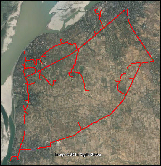
It's hard to say what you should start using to plan journeys, I use both RideWithGPS and Google Earth for most of my planning, whether it be cycling or walking. Below is an image where I've used Google Earth to plan out the routes to Temples in Bagan, Burma. I've put those tracks into the iPhone and navigate using the Gaia app.

http://ridewithgps.com

https://www.google.com/earth/

BaganGPS

Bill Law BPL Member
PostedAug 4, 2014 at 9:29 am

I’ve used CalTopo to map out routes. I just print them out, but I think you can export files that can be loaded onto a GPS. You can either click individual points on the map, or, use some non-intuitive keystrokes to trigger continuous route tracing as you move the mouse (Ctrl+shift+click or something like that; I just figured it out recently, after using it for a year).

Dena Kelley BPL Member
PostedAug 4, 2014 at 11:14 am

I've found creating routes with roads to be easy. Creating routes with trails- not easy.

My solution with trails has been to keep my GPS running and create a track going in. Then, if I want, I save the track and overlay it on my GPS map and can follow it back out. I create waypoints at important features- water, splits in the trail, etc. Sometimes my waypoint will have a description such as "take left".

Diane Pinkers BPL Member
PostedAug 9, 2014 at 7:55 am

I've played with this a little, seem to be able to wrestle it more or less into what I want to do. I got most of the first day's trace laid down, and was able to create an elevation profile from it. Just need the time to sit down and really work at it.

Thanks for the help! Elevation profiles are not essential, but I find them helpful in gauging relative effort and how far I may travel in a day.

Viewing 8 posts - 1 through 8 (of 8 total)
Loading...