


Creating a seperate thread for this.
Anyone stay at Hitchcock lakes or other?
I'm looking to avoid the guitar lake crowds.
Is it much more difficult to get from Hitchcock back to trail for the whitney summit?
Topic
Become a member to post in the forums.
Creating a seperate thread for this.
Anyone stay at Hitchcock lakes or other?
I'm looking to avoid the guitar lake crowds.
Is it much more difficult to get from Hitchcock back to trail for the whitney summit?

Go 1 mile beyond Guitar Lake, 500 feet higher (~12000'). Not long before the switchbacks, there's a tarn (pond) near to the trail, and 5 or 6 established sites among the rocky outcrops north of the tarn. The sites aren't visible from the trail, but only 50-150 yd from the trail, and easy to find when you see the tarn. There's reasonable privacy here – the sites are close together, but pretty well secluded from one another. And spectacular views of course. This is one of my favorite campsites in the Sierras (Guitar Lake would be one of my least favorite). There's usually space here even when Guitar Lake is crammed – perhaps people worry that there won't be any more water and are reluctant to go higher. I guess you'd better burn this message after you've read it in case it falls into the wrong hands.
I came in here to pass along the same information re: the tarn. I think part of the problem is that most of the popular guidebooks make a big point of saying that Guitar Lake is the last water before Trail Camp on the other side.
I camped at the tarn about a week ago (well, took a nap in advance of a night hike to the summit), and there were maybe three people camping in a reasonably dispersed manner. After seeing this spot, I won't be camping at Guitar Lake anytime soon.
Thanks guys!
I saw that on the topo, and was just considering loading up on water and just heading that way hoping for a flat spot to camp. Nice to know there's actual spots there.
Anyone ever stayed at Hitchcock lakes? Google isn't turning up anything….
"Go 1 mile beyond Guitar Lake, 500 feet higher (~12000'). Not long before the switchbacks, there's a tarn (pond) near to the trail, and 5 or 6 established sites among the rocky outcrops north of the tarn. The sites aren't visible from the trail, but only 50-150 yd from the trail, and easy to find when you see the tarn"
Ralph, and those of you who know of this spot, is that the tarn that's visible on the topo map just east of Guitar Lake, or is it smaller than that? I'm looking through my pix of this area from last year and I think I only see that other small lake…..
My plan is to camp as far up Whitney as possible the night before my summit this year, so I'd love to get a bit higher than Guitar Lake if possible. This sounds like a wonderful option!
Jen,
There are a few nice flat but somewhat exposed sites between switchbacks on the way up to Whitney. If you are heading up in the light hours you'll see them below you. Nice flat dirt areas with small rock walls surrounding them. Likely too close to the trail legally but nice and high up and very well established. No water there.
Jennifer,
The USGS Topo that I'm looking at has two small lakes south of some switchbacks about 0.25 miles east of Guiter Lake – this is NOT the right place. You need to go further – I'd say exactly 1 trail mile beyond Guitar lake.
Elizabeth Wenk gives:
elevation 11,940'
coordinates 383452 4047401
From memory, those coordinates look accurate. I don't see the tarn marked on any map, just some "marshland" symbols nearby on the Topo. I don't know how seasonal the tarn water level might be, but I was there in early Sep last year (also a dry year) and it had plenty of clean water. It's the last water on the way to the summit.
I wouldn't worry too much about finding it – it's really not hard to find. The tarn is to the right (SW) of the trail, quite close, it's small but I'm almost certain that it's visible from the trail. The campsites are on the NW side of the tarn, among rocky outcrops.
Ralph
Thanks guys – that's exactly what I was hoping to hear! I remember on our way up last year thinking wow, there are a lot of nice places to camp up here!
I've added some slop days between MTR and Whitney this year, so I may break up my Forester Pass -> Guitar Lake stretch into 2 (3?) days, to better set up an early summit. And of course, I'm trying to beat Marko for the Slowest Known Time for the SOBO JMT.
Ralph, there's NO way you'll catch my record on THAT one!
The guthook iphone app has a marker on the trail there at 206.6 on their mileage listed as "there are five potential tent sites in the area" with a picture.
FWIW is has another marker where the two small lakes are with the swamp symbols, but that is earlier, mile 206.2 and it says 3 sites. Last water listed is there, but if the other one is far enough off the trail maybe they missed it or don't count it. The last one is about 300 feet above the first one (and about 527 feet above Guitar lake) and 0.4 miles after it. FWIW the stream going into Guitar Lake just east of the "neck" is listed as 205.8.
Jennifer, I think in order to properly motivate ourselves in the SKT category we need to have as a goal time equal to certain integer multiples of Ralph's time. For example be the "first" to do an 8RB SKT, or a 10RB SKT, and so on. I originally wanted to shoot for a 1-Skurka PCT time, but I realized I need more training – and possibly to eat more Twinkies and watch more Netflix in preparation. The really hard thing to explain to people who are unwilling or unable to try for a SKT is that they don't understand how HARD it is after a few days NOT to walk. You whole body is screaming that it wants to walk – the genetic heritage of endurance hunters like humans and dogs, that Ralph posted about in another thread, kicks in. There is only so much a sedentary lifestyle and couch surfing can do to suppress this. Once this kicks in I find it takes tremendous discipline and willpower not to walk 20 miles a day. ;-)
There is a small lake above guitar lake. May or may not be as crowded as guitar lake, but its close to the switchbacks. And, you can get an awesome twighlight view. My second favorite campsite of my trek. Even with the dozen others 50 yds away.
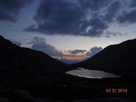
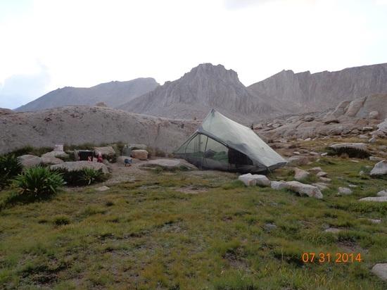
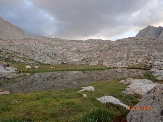
The tarns are certainly better than Guitar Lake. But last time I walked past the tarns, in 2013, they were already full of tents. Maybe 5 tents. Any additional tent sites in that area were really marginal.
Hitchcock Lake is beautiful. No people there. You can angle straight there from the east side of Guitar Lake. It may take 30 minutes, depending on your route-finding skills. Alternatively, if you have Class 2+ cross-country experience, the more direct route is to hike up Hitchcock's outlet from where it spills into Timberline Lake. In the morning, you walk from Hitchcock towards the tarns and rejoin the trail there.
– Elizabeth
The Sierra (not sierras) is ONE mountain range. Sierra Nevada is Spanish for snowy range. The California Miwok named it "Kayopha – the sky and the peaks that touch it". John Muir called it "The Range of Light".
Become a member to post in the forums.
 New Ultralight GearSee the latest releases in ultralight cottage-brand gear from small makers.
 © Beartooth Media Group Inc.
 Loading...