Topic
What does everyone think of the new US Topo map type from USGS?
Become a member to post in the forums.
- This topic is empty.
I've been using plain ol' topo maps for most of my life and haven't tried adding extra layers to it. I'm sure this adds useful information for some people but too cluttered for me.
I've noticed the same thing
New version has pretty colors and things but actually less information, like they don't show trails. Maybe I just haven't "turned that on" or something.
New version "looks better" to someone that's just looking at pretty colors and things but not so good to someone that's using it to hike
Ah – photo-topo maps.
The Australian mapping authority tried that many years ago. It was pretty much a disaster, for the obvious reasons. Pretty enough to look at on the wall, but almost impossible to use seriously in the field. I predict they will die within a year or two.
Cheers
I think that you are looking at two selected maps, and you should not indict USGS maps in general. The USGS maps that I use look like neither. Nearly everything that I use is from the old National Geographic TOPO! program, so it is more like the first one and much less like the second one.
The only thing that I stumble upon is the English-Metric problem. Some USGS topo maps show the major and minor contour lines in English units of feet. Some show lines in meters. The TOPO! program will allow the user to select which is preferred. Then, when the user clicks on a spot, it will display the estimated elevation in the proper units. However, the base maps only show English or show Metric contours.
I had printed out a large area of map that I was going to use for five or six days, and it happened to contain metric contour lines. When I got out there and I needed to pick my own cross-country route while side-hilling, the map only showed me metric. My GPS receiver showed feet, and I had to rationalize the two. It took a while to remember how to get into the GPS setup menu so that it would do the conversion for me. It was either that or else I was going to have to pull out my slide rule.
–B.G.–
You can get them to look like the older version by viewing them with Adobe Acrobat or Reader and deselecting the images layer.
It would be nice if the trails were still present, but I think they've shifted a bit over the years.
USGS maps without trails? What is the point?
First,as Jeremy B said, viewing the topo files in Acrobat or similar PDF readers allows you to turn off the aerial imagery layer.
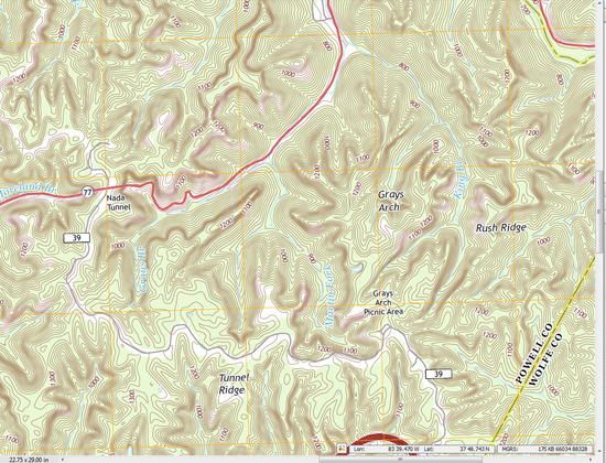
See the attached example.
According to this link:
http://nationalmap.gov/ustopo/about.html
they do plan to add back USFS trails. I'm not sure what happens to all the other trails that were on the old maps from National Parks, Wilderness, state lands, etc.
I suspect that because they've gone digital, the USGS just doesn't have the "layer" data right now to add that as a layer. Which sucks.
http://nationalmap.gov/ustopo/ustopo_news.html
States they are now on a 3-year update cycle. New camps for all 50 states were completed in 2012, and now they are beginning to publish a 2nd round of revised maps. The example I included here is a 2013 version of the Slade, KY area, revised from the original 2011 version. Newer PDF versions include a relieve shading layer, if you're into that sort of thing.
While searching for any ongoing discussion of when trails would actually begin to appear on revised "US TOPO" maps, I came across the CalTopo blog and his thoughts about the new map system.
It's also interesting reading.
http://caltopo.blogspot.com/2012/04/working-with-us-topo-maps.html
Yeeeech!
Become a member to post in the forums.