Topic

Lake Edison Ferry

  • This topic is empty.
Viewing 25 posts - 1 through 25 (of 30 total)
Dan Magdoff BPL Member
PostedJul 2, 2014 at 11:59 pm

Hey all

SO I havwe heard some conflicitng info about the Lake Edison Ferry for this summer. I beleive the word was it would be running once a day in the AM. I wanted to give some correct information for all those hiking the JMT and PCT and are planning at stoping at VVR. Last I heard, the Lake Edison Ferry will NOT be running this summer. The lake is already pretty much empty. if anyone has heard differently please post.

John Rowan BPL Member
PostedJul 3, 2014 at 9:09 am

Well, my JMT hike just got some walking added to it.

I'm definitely heading in there via the Edison Lake Trail (I know they recommend going over via Goodale Pass, but I really don't want to skip that much of the JMT), but I'd be curious if anybody can chime in re: whether or not I'd be better off taking Bear Creek Trail back to the JMT or just rejoining it where I came in at Edison Lake.

I know VVR recommends Bear Creek over the Lake Trail/JMT, but I don't know if that's the prevailing experience.

I'm trying to get close to MTR for the next night's camping (targeting Senger Creek), so it looks like doing either of those options bumps me to 21-22 miles for that day. That's a bit more than I'd like, but certainly doable.

PostedJul 3, 2014 at 9:30 am

The reply was posted on the VVR site 10 days ago.
I have a friend that helped open Muir Ranch this season and they said Florence Lake is in good shape.

David B. • 15 days ago
Hi. hard to tell from the comments below, is the ferry running this year ( June 2014 ) I plan to be there late July 2014, what are the chances the ferry will be operating? thank you, david b.
Reply

Bill Richardson Mod David B. • 10 days ago

Yes, the ferry is running this year. See our page on the hiker ferry for updated times.
•
Reply
•
Share ›

Adam White BPL Member
PostedJul 3, 2014 at 9:53 am

> I’m definitely heading in there via the Edison Lake Trail (I know they recommend going
> over via Goodale Pass, but I really don’t want to skip that much of the JMT), but I’d be
> curious if anybody can chime in re: whether or not I’d be better off taking Bear Creek
> Trail back to the JMT or just rejoining it where I came in at Edison Lake.

> I know VVR recommends Bear Creek over the Lake Trail/JMT, but I don’t know if that’s
> the prevailing experience.

John,

There’s actually some pertinent discussion over at the Food, Hydration and Nutrition forums here.

In particular, see Jennifer Mitol’s post.

John Rowan BPL Member
PostedJul 3, 2014 at 10:05 am

Thanks for the heads-up….dropping a reply in there now to clarify what Jennifer was saying (although it sounds like she took the JMT instead of Bear Creek and was glad to have done so.)

I need to go back and take a better look at that thread in general, since there's a lot of good information in there.

Adam White BPL Member
PostedJul 3, 2014 at 2:16 pm

Aaron, I think that's an old image–Google says the imagery date is 9/14/13.

My guess is that if the folks at VVR say they're running the ferry, the lake is filled again.

(edit: the folks at VVR DON'T say the ferry is running, that was the Florence Lake ferry. Reading comprehension fail on my part.)

Edison

John Rowan BPL Member
PostedJul 3, 2014 at 2:20 pm

For what it's worth, VVR posted the same picture to their Facebook page. (Or one that's basically identical.) Oddly, they didn't say anything about the status of the ferry on there when they posted it.

Adam White BPL Member
PostedJul 3, 2014 at 2:38 pm

> For what it's worth, VVR posted the same picture to their Facebook page.
> (Or one that's basically identical.) Oddly, they didn't say anything about
> the status of the ferry on there when they posted it.

Well, I stand by my point that the Google Earth image is old, but I suspect that Aaron is correct–the lake is still dry.

On VVR's message board, they posted a month ago that the lake was too dry for the ferry to run, and that they'd post an update if that changed. No update.

Also, from a NoBo PCT'ers instagram today:

The Ferry

They're going to have to put (edit: bigger) wheels on the ferry before they can run it.

PostedJul 3, 2014 at 2:48 pm

Oh, no contention here…

Just interesting to see the same images with different dates.

Makes me remember to take nothing for granted, including the date at the bottom of a google image.

John Rowan BPL Member
PostedJul 3, 2014 at 2:55 pm

I'll be there in 2 weeks and then I can try for cell reception and solve this for everyone once and for all.

(Okay, probably not. I'll be too overcome by the prospect of real food and beer. Also, coffee, delicious coffee.)

Adam White BPL Member
PostedJul 3, 2014 at 3:01 pm

Last year, when the lake was empty, I heard two things: 1) that hiking through the dry lakebed was the easiest way to get to VVR from east side of the lake, and 2) that you could get AT&T reception from the bottom of the lakebed.

So, maybe while you're walking across the lake bed, post here?

PostedJul 3, 2014 at 3:11 pm

"At VVR, we have provided Internet access via satellite for those hikers who need to check their email or upload blog entries for the trail. In addition, we have VOIP service for calls home, and AT&T cellular coverage from the beach."

Roaming ?

Adam White BPL Member
PostedJul 3, 2014 at 4:09 pm

> Funny, my computer says it's a 2014 photo

I could be wrong, but I'm pretty sure the satellite view from Google Maps always says the current year, regardless of when the imagery was taken.

The only way I know of to get the actual imagery date is to look in Google Earth.

PostedJul 3, 2014 at 4:29 pm

The first time I googled, then went to Maps, I found the 2014 label by the Ag Dept.

When I used Google Earth I came up with the 2013 image.

Go Figure…

Adam White BPL Member
PostedJul 3, 2014 at 4:49 pm

Here's one from Terraserver, dated 5/24/14:

2014

Compare with 5/30/11:

2011

Marko Botsaris BPL Member
PostedJul 3, 2014 at 4:57 pm

Well, if the lake drys out enough by early September maybe I can hightail it across the lake bed. Maybe the best case scenario of all. :-)

Probably i will just be sand and smelly mud though. :-(

Dan Magdoff BPL Member
PostedJul 3, 2014 at 4:57 pm

SO I am running the Florence Ferry this year and can tell you it will be running. Southern California Edison Company controls the water levels of the lakes. There was a meeting with them last month and they said that Florence would be kept partially full at around %40 or something like that, and Edison would be drained at like %5 or some ridiculous low number.

It would be the shortest route to hike through the lake bed at Edison, but I am not sure about the easiest. It will be very sandy and there are lots of culverts that create big sandy ravines/ dunes to hike in and out of.

There is cell service at Mono Hotsprings jut down the road from Lake Edison, but I am unsure about at Lake Edison.

I have hiked up Bear Creek many times, and will be actually hiking up it again this summer. Its a beautiful hike with great fishing and swimming holes and is a really easy hike to connect to the JMT.

If you do happen to take the Florence Lake Ferry between July 21-August 4th be sure and say hi!

Marko Botsaris BPL Member
PostedJul 3, 2014 at 5:03 pm

"I have hiked up Bear Creek many times, and will be actually hiking up it again this summer. Its a beautiful hike with great fishing and swimming holes and is a really easy hike to connect to the JMT."

Good to know. This is what I had heard. Someone posted that some friends "went that way" and they took longer and said it was horrible. I just assumed those people got the other (nasty) alternate route that goes along the ridge confused with the Bear Creek route. On the topos Bear Creek looks much nicer that either, and potentially more fishing friendly as well. Looking forward to it.

Dan Magdoff BPL Member
PostedJul 3, 2014 at 6:53 pm

Ya Bear Creek Ridge sucks…much steeper, hot, dry and dusty. The trail along bear creek is really beautiful. its one of the only streams in the Sierras where you can catch rainbow and brown trout in the lower section, brook trout in the middle and Golden trout in the upper section. In years with good water flow the creek has beautiful waterfalls and great swimming holes.

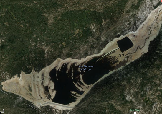
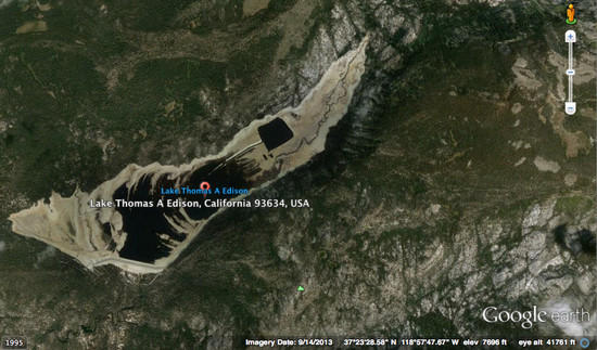
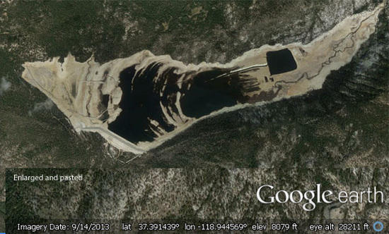
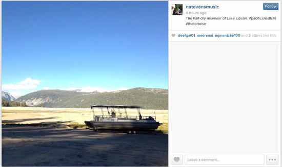
I am guessing Edison is reluctant to update there website because it will mean a big loss in business for them. They have a VERY short season as it is, and its a tough place to run a business, so when you take out business from backpackers and the ferry its going to be a tough season for them. if ya'll can, I would still try and get into VVR to support them even though it will be a bit more hiking. You could also consider a lay over day into Mono Hot Springs from there…its a bit crowded but there are some GREAT hot springs in the meadows there which are nice to soak your aching bodies and feet in after days on the trail. AND the restaurant at Mono Hot Springs has some tasty food. It would be really easy to hitch a ride from Edison to Mono Hot Springs, camp there for a night and then hitch a ride from there back to the Bear Creek TH. The only problem is most people will drop you off at the start of the Bear Creek Diversion Dam rd which is a 4×4 rd. its several miles long….the TH is at the end of that rd at the Diversion dam. Hiking along that road sucks…really hot, dry and exposed.

Anyway…like I said, be sure and come see me on the Florence Lake Ferry if your around when I am there (July 21-August 4)….a cold drink is on me :) I am normally there all summer, but getting a real job but a damper on that.

Viewing 25 posts - 1 through 25 (of 30 total)
Loading...