Topic

Campsites along Grand Canyon of Tuolumne?

  • This topic is empty.
Viewing 25 posts - 1 through 25 (of 28 total)
Arla Hile BPL Member
PostedMay 28, 2014 at 9:51 am

Two of us are planning a 3-day trip from White Wolf for late next week, down via Pate Valley into the Grand Canyon of the Tuolumne, then out past Glen Aulin and Ten Lakes back to White Wolf.

Looking at spots around 15 mi in, I'm concerned that we'll be in a rugged canyon without too many good spots (plus I expect it's going to be pretty cold and potentially windy down in there). Anyone set up camp along that stretch?

Second afternoon we should be coming down into the South Fork of Cathedral Creek. I'm guessing there should be ample places to bed down along there, but if anyone has a favorite I'd love to hear about it.

Many thanks in advance,
Arla

PostedMay 28, 2014 at 10:42 am

Hey, I just got back from hiking the Grand Canyon of the Tuolumne a few days ago. I haven't had time to post a trip report yet, but I will.

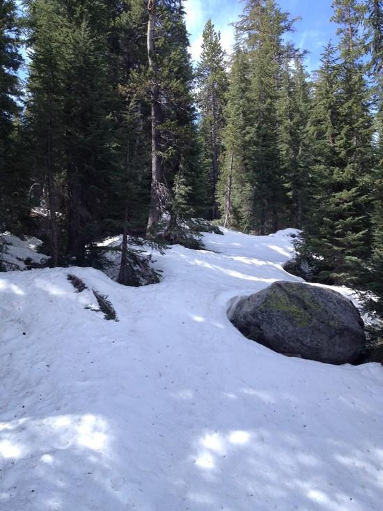
I'm not sure I'd recommend going back via Ten Lakes. The trail between Glen Aulin and Tenaya Lake near Polly Dome Lakes was covered in snow and was impossible to find–I had to navigate off-trail the old fashioned way (topo map and compass). It cleared up eventually, but I'm sure it is much worse at higher elevations. In fact, at the end of my hike, I hitchhiked out with a couple who tried to hike to Ten Lakes and said there was significant snow up there.

Anyways, the canyon itself is fantastic, and it was perfect conditions when I was there. There is plenty of camping almost the entire way through the canyon, but my favorite spot was roughly 15 miles in, a bit past the Register Creek crossing (it's a creek crossing that is close to a waterfall, I'll post a picture later). After you do the crossing, you climb some switchbacks until you get to a gorgeous view of Muir Gorge. Then, you descend a bit and meet back up with the river. There were some great spots not far from the trail there (again, I can post a picture later for reference). It was roughly this area on the map:

a

(Full size here: http://i.imgur.com/IIaBGnt.png)

Also, the trail junction in Pate Valley immediately after the bridge crossing was a tad confusing. A tree had fallen on the sign indicating the way to Glen Aulin, and also concealed the trail. If you go right, you'll find the trail soon enough.

Watch out for rattlesnakes in the canyon, as there were quite a few on the trail when I was there.

It wasn't windy and certainly wasn't cold when I was there. It was actually quite hot, and even at night it was pretty warm in the valley (maybe mid forties at the worst?).

PostedMay 28, 2014 at 10:52 am

Actually, if it's late next week, it may be OK to go via Ten Lakes, but I'd maybe call and ask first. I was there a week ago, so conditions may have changed since then.

I hiked from roughly the White Wolf area to the spot that I marked in one day, but it was a long one. I wouldn't plan on going blazingly fast from White Wolf, but it's definitely doable if you start early. Again, there's good spots every mile or so in the canyon, so you're fine if you don't make it all the way.

PostedMay 28, 2014 at 4:22 pm

Thanks for this info, Brendan – I'll be following this thread as I'm planning a trip up there next weekend. How were the water crossings? I'm hiking solo, so I've been a bit nervous about them this early in the year.

Arla Hile BPL Member
PostedMay 28, 2014 at 6:51 pm

Thanks Brendan, yes I was wondering about the area around Tuolumne Peak and Ten Lakes Pass. I've done a fair amount of winter navigation and it both slows me down and wears me out! Did you see any spots around the Return Creek bridge that might be ok for camping?

Hi Erica! :)

Pedestrian BPL Member
PostedMay 28, 2014 at 7:17 pm

I did the clockwise loop down thru the GCT starting/ending at White Wolf about 8 years back. There is an excellent little spot just past the Return Creek bridge where you can camp. It's not even a 100 ft from the creek so technically you'd be too close for camping….

Arla Hile BPL Member
PostedMay 28, 2014 at 8:06 pm

Thanks, Ped!

Looks like another option to bailout is to hike up to Tuolumne Meadows store and catch the 10:15am YARTS bus to White Wolf ($3, weekends only). I'll have to check where the last spot that's legal for camping is along that route…

PostedMay 28, 2014 at 11:30 pm

Erica,

There are only two stream crossings that were risky in any way shape or form, and they were not too challenging at all. I was also hiking alone, so I acted in an abundance of caution. The only tricky/intimidating part of these two crossings is that there are small waterfalls immediately after where you are crossing, so if you were to fall you'd tumble down those. Otherwise, they are a piece of cake. You'll see in the pictures.

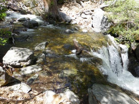
The first is the Morrison Creek crossing, which happens on the descent into the canyon from White Wolf:

1

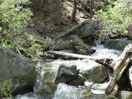
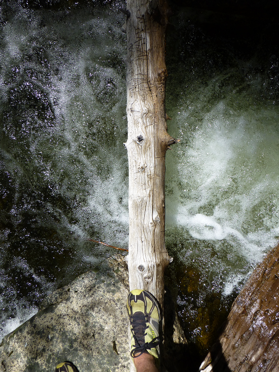
So, it actually looks pretty wimpy from this picture, but it was my first stream crossing in a while and I didn't want it to be my last. I looked slightly upstream and found a better option: a log that crossed the creek…

2

3

It wasn't the appeal of keeping my feet wet (my feet were wet for 50% of the trip, probably), but it seemed like a safer option all around. My reasoning was that if I were to slip and fall on the "regular" crossing, I was going immediately overboard. If I slipped and fell on the log crossing, I would have time to recover. I also was able to gently toss my pack across the creek so that that wouldn't burden me if I slipped. It was maybe two or three steps on this log (it's not very wide, but it's stable) to cross. No problem.

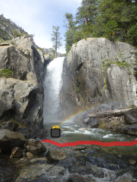
The second creek crossing is the Register Creek crossing that is roughly 6 to 8 miles past the Pate Valley junction:

6

This isn't quite as clear of a photo, but it's the best one I have. This one was a little deeper–I'm 6 feet tall and it came up to maybe mid thigh–so 2-2.5ft. It wasn't too bad at all, but earlier I grabbed a nice sturdy hiking staff along the trail to help me balanced. There's a part that looks like a small stone path, and that's where you want to cross. There is also sort of a small "shelf" of rocks to the right of you as you're walking, so that helps a little. It was cold, but not difficult.

I suspect that these crossings will be even easier by the time you all are hiking it, since I did this part on May 17th.

Also, I just realized you can tell how pedantic I am by these posts…

PostedMay 28, 2014 at 11:43 pm

Also, I encountered three rattlesnakes while I was in the canyon, so that would be the greater safety concern in my opinion. The first was a small one, and I spotted him ahead of time. "Where there's babies, there's mommas" I thought to myself, so I kept my eyes glued to the trail. Still, I was rounding a corner and swatting bugs out of my face simultaneously and completely missed the second rattlesnake–an adult. It slithered out of the way and glared at me admonishingly as if to say, "be more careful, bro". Those two snakes were before the Pate Valley junction. I didn't see any other human that entire day, and I hiked probably 18-20 miles. It would have been an issue if I had the misfortune to get bit.

The last one was on the following day, kind of near the Tuolumne River on a rocky part of the trail a few miles past the Register Creek crossing. I came even closer to stepping on this one, I think (although not too close…it's hard to remember, but it was maybe 2-5 feet in front of me).

That was really the only thing that spooked me about hiking solo on this particular trip (it was actually my first solo backpacking excursion!) I wish I had been more prepared and brought some sort of emergency communication device in the unlikely event that I stepped on one of those snakes, because I would have been capital S Screwed. There's no easy way out of the canyon once you're down there, no cell reception at all, and there were no/few other hikers down there.

Not trying to scare you too much, but if you have a Spot device or similar, I'd bring it. Don't let it impact the enjoyment of your hike at all, just keep an eye out and be careful where you step. They love to chill on the trail, but it is worth it to poke around with a hiking stick or trekking pole if you are wandering into the brush to use the bathroom or something.

That said, I practically tried to step on the damn things and they go the hell out of my way as fast as they could. This is their normal behavior, from everything I've heard.

Bob Gross BPL Member
PostedMay 28, 2014 at 11:45 pm

As Brendan reported, Morrison Creek can be awkward. This year should be relatively easy compared to a normal year. A friend of mine got hurt trying to cross that stream.

I recommend using some good trekking poles or some good cords strung up to hold onto. You can get one cord end tied, then use it to support you while you walk an arc across the stream. Then on the second bank, you tie that cord end off, cross back, untie the first cord end, then walk an arc back across to the second bank again. Thereby, you have recovered your cord.

I have a 100' dyneema cord that will support 100 pounds, and the whole thing weighs only 7 grams. So, any sort of good cord should not be too heavy.

–B.G.–

Bob Gross BPL Member
PostedMay 28, 2014 at 11:49 pm

"Those two snakes were before the Pate Valley junction."

I agree completely. The last time that I hiked through there, there were two snakes before Pate Valley and another two afterward. I think they like the heat there.

–B.G.–

PostedMay 28, 2014 at 11:57 pm

So regarding Ten Lakes, the couple that I hitchhiked with (more on that later) approached Ten Lakes from the other (west) side. They said everything was fine until the last mile or so to Ten Lakes, and then it was "several feet of snow" and gave up (but it was their first backpacking trip, so who knows). It's not the same trail, but someone else said that Cloud's Rest (9900ft…at least 500ft higher than Ten Lakes) was "mountaineering conditions". It may be a totally different story 3 weeks later, so it's worth calling and asking.

I lost the trail completely before I got to Polly Dome Lakes, but it only took me maybe 1-1.5 hours of careful navigation to recover and find it again. The main issue was that I was in dense forest with lots of little lakes/ponds, so it was hard to tell precisely where I was or exactly what pond I was standing next to. There was also definitely some sporadic postholing action going on. Overall, it was a navigation issue–the snow travel aspect was actually quite fun.

324

Actually, it may not be accurate to say that I lost the trail entirely. There were frequently hints of a trail–a flat and worn piece of ground, a small cairn, etc.–but they would disappear without a trace just as quickly. I probably kept criss-crossing it as I went.

Bob Gross BPL Member
PostedMay 29, 2014 at 12:18 am

In tough conditions like that, with snow covering the trail, etc., it is really handy to have a GPS receiver to put your position on a map. This is especially true when there are enough trees around that you can't find any good landmarks with which to triangulate your position by traditional methods.

–B.G.–

PostedMay 29, 2014 at 12:35 am

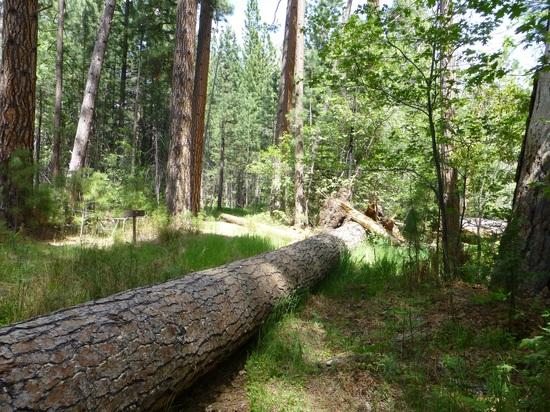
This isn't that bad, but it caused me a moment of confusion and I ended up backtracking to make sure I didn't miss the trail. This is the Pate Valley junction, but one of the signs, as well as the trail, was mysteriously missing…

j

Hint: it's underneath the tree.

aa

It looked like this tree had fallen recently, and it happened to fall directly on the trail that you want. This was also a metaphor for my crushed dream of making it 14.3 more miles to Glen Aulin to camp for the night.

Don't go straight, but head right in the direction the tree is pointing and the trail is immediately visible.

PostedMay 29, 2014 at 12:36 am

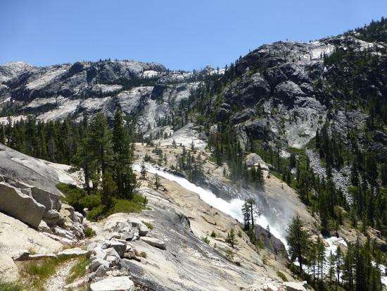
So since my replies have been all about potential drowning spots, snakes, trails that disappear beneath snow, and gloom and doom, here are some nice photos to round things out. The Grand Canyon of the Tuolumne trail is sublime. It's overwhelming how beautiful it is down there, so you will immensely enjoy your hikes (and thank you to Bob for the recommendation, by the way). Also, apologies for pseudo-hijacking this thread and turning it into my post-trip report.

311

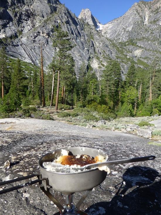
This is a scene from the Great Pancake Calamity of 2014, in which I attempted and failed to make pancakes on a pan without nonstick. It's hard to complain with views like that, however. This was ~1.5 miles past the Register Creek crossing if I remember correctly, and the campsite was a nice flat, well-established area near those trees to the left. I highly recommend it if you can hike that far from White Wolf in one day (I hiked from 8am-6pm to get there from near White Wolf). If not, there's plenty of other spots to camp.

And here is one of the many phenomenal scenes that you can expect.
adf

Arla Hile BPL Member
PostedMay 29, 2014 at 8:47 am

Brendan – Thanks for great reporting and fantastic photos! Those stream crossings look like no biggie, especially with two of us. Love the pancake photo!

My hiking partner has these crazy-light snowshoes (Northern Lite Elites, around 37 oz) and now I wish I'd ponied up for a pair after she raved about them. Guess it's going to be post-holing for me.

PS I don't think you're being pedantic at all, I really appreciate all the info!

PostedMay 29, 2014 at 8:52 am

Beautiful!! Thanks for sharing your trip and sharing the all of your info! Also, Brendan, were the mosquitos bad when you were there?

PostedMay 29, 2014 at 10:19 am

That's ok, I think snowshoes would have been overkill unless you were planning on traversing through higher elevations. I ordered a pair of YakTrax from Amazon to try out and carry as insurance, but they didn't arrive in time. I was fine without them, however.

Erica–the mosquitos weren't bad at all, in general. There were several random patches where they were dense and aggressive, mostly in forested areas near the Tuolumne River. However, there were very few of those spots, and they only bothered me if I tried to lay down and take a break. Otherwise, there were very few if any mosquitos.

Also, let me know if you have any other questions about the route, what gear to bring, etc.

Arla Hile BPL Member
PostedMay 30, 2014 at 2:01 pm

We did a little more homework and found out that the YARTS shuttle runs from White Wolf to Tuolumne Meadows at 6 pm and arrives at the Tuolumne Meadows Visitor Center at 6:45. One-way fare for one is $3. Then you have to hike in at least 4 miles to camp. Sunset isn't until 8:18 pm so that's a piece of cake. Plus we can do a little day-hiking in the Valley before we head up Tioga Rd. Really looking forward to this trip, thanks for all the great input!

Marko Botsaris BPL Member
PostedMay 30, 2014 at 9:51 pm

Technically there I think you have to go to, or past, Glen Aulin, and that distance is a good bit longer than that. You are also supposed to be 1/2 mile past Glen Aulin if you don't have a spot there. So probably going to be dark before you get there.

Still, if it is a pleasant night might be a good excuse for some night hiking? On the other hand the last half of the walk to Glen Aulin is very nice, and if there is no moon you are going to miss some nice water falls and such. The confluence of all the rivers right at Glen Aulin is not to be missed.

Hitching earlier is likely to work. I have picked up a bunch of backpackers on that stretch over the years.

Bob Gross BPL Member
PostedMay 30, 2014 at 10:02 pm

What good does it do to get a ride to Tuolumne Meadows if you are starting at White Wolf?

–B.G.–

Bean BPL Member
PostedMay 31, 2014 at 1:42 am

It's not the same trail, but someone else said that Cloud's Rest (9900ft…at least 500ft higher than Ten Lakes) was "mountaineering conditions".'

I did clouds rest from Tenaya Lake couple weeks ago, there was some postholing… but that was about it. Saw a lot of day hikers turning back, but a girl ahead of us in Teva's, shorts and a tanktop blazed through it without a problem.

PostedMay 31, 2014 at 10:41 am

Arla, I had thought you said you were going to start at WW and head to TM. The YARTS back to WW is at 10:15 a.m. on weekends per my reading of their June schedule. Glen Aulin to TM is ~5.5 mostly flat miles, so you may need an early start to be sure of catching the 10:15 at the store.

I do recommend doing the hike eastward from WW to TM if you can. You avoid the big last day climb and you generally face towards the half-dozen falls/cascades on the T itself.

Brendan, thanks much for the trip report. Looks like the snow south of May Lake was heavier than end of May last year, probably because you were ~2 weeks earlier than I was.

Arla Hile BPL Member
PostedMay 31, 2014 at 10:20 pm

Yeah, I know…but I have someone else to coordinate with. We can catch a bus from White Wolf at 6pm then hike back down to our car with no worries about catching a bus and work is calling. I get that. Not exactly what I wanted to do but there ya go. Hey at least we have permits to do the John Muir Trail starting July 22 so I won't feel very deprived this summer.

Bob Gross BPL Member
PostedMay 31, 2014 at 10:40 pm

I guess you know that permits may be hard to come by. The trail from Tuolumne Meadows to Glen Aulin is very popular.

–B.G.–

Viewing 25 posts - 1 through 25 (of 28 total)
Loading...