Topic

Superstition Wilderness questions for end of Feb bp trip

  • This topic is empty.
Viewing 8 posts - 1 through 8 (of 8 total)
Ben H. BPL Member
PostedJan 22, 2014 at 4:28 pm

Going to be in Phoenix the end of February for work. I talked a co-worker into going backpacking for 2-3 days after the business trip. I am wondering if anyone can answer questions I have on the Supe's?

It looks like the Southeast side is the greenest part of the wilderness. Is that correct? Is water fairly accessible this time of year?

I was kind of looking at Miles, Woodbury, or Roger Trough Trailheads. All three of these list 4wd or high clearance vehicle required. Let's say you have an unknown rental car and a lax attitude toward underbody scrapes… which one of these trailheads do I have the best chance of making it to?

How are bugs this time of year? Do I need a tent?

Ben H. BPL Member
PostedJan 27, 2014 at 8:47 am

a bump in case any AZ hikers come inside….

HkNewman BPL Member
PostedJan 27, 2014 at 9:12 am

My only Superstitions experience is a couple late Jan on the northern side of the wilderness and not the southeast side you are looking at, so take my comments with a grain of salt. The northern road bordering the Supes was not paved (as of 2007) but 2wd vehicles were on it (an Arizona highway dept road motor pool was close to the TH I used). Just dusty with some rocks but the highway crews scraped it clear. The northern area is full of Phoenix residents getting away to the adjoining manmade lake, so I imagine the roads are still maintained even after budget cuts.

The bigger issue is Feb is the start of Arizona's first rainy season and the condition of any non-paved road after significant rainfall. There are some bigger trailheads which are closer to pavement closer to Phoenix. That said, some of the smaller TH's closer to Phoenix have had vandalism problems with hiker vehicles, … so much so that a few hiking clubs had fence enclosures for their vehicles on adjacent public lands.

In terms of greenness, it's more a function of elevation. Going to Reavis Ranch, I started in Sonoran desert cacti and ended up in coniferous forest. If the spring rains come through, you will likely see more green vegetation. When it comes to bugs and critters, I'd say watch your hands even with a traditional tent. I've been stung by scorpions on a number of separate occasions just opening a tent flap (they love to hang out in folded fabrics, .. all cuddly-wuddly)

J-L BPL Member
PostedJan 27, 2014 at 10:02 am

It is hard to say right now since AZ has had such little (any?) rain in 2014. I would not recommend Roger's Trough trailhead with a sedan. Reavis Ranch will have the most reliable water and gives a very nice overview of the Superstitions. If you approach it from the 109 North trailhead, a sedan can make it easily if it's not raining. If there is any rain or snow, I would not bother heading there – the road crosses two washes which can run very deep and should not be attempted with any car. I tried hiking Reavis Ranch 3 times last February/March and the road was flooded the first two times, but it was a wet winter:

http://hikearizona.com/decoder.php?ZTN=246

If you're willing to drive a little further, you may look into these hikes near Sedona:

http://hikearizona.com/decoder.php?ZTN=755 (may not have water – watch weather for recent rain/snow)

http://hikearizona.com/decoder.php?ZTN=86 (will have water)

Ben H. BPL Member
PostedJan 27, 2014 at 4:55 pm

Thanks HK and John!

I was looking at Revis Ranch TH but was kind of turned off by what looks like a long dry exposed slog over Windy Pass. Just from using google maps and trail maps coming from the south seemed more appealing. I guess I should learn to listen to the experts. I was worried you had to get 8 miles or so from Regis Ranch TH before you get any water. Is that true or is water available before windy pass?

If it is rainy that weekend, I was thinking of going to the Peralta TH. Thanks for some alternative ideas up near Sedona.

J-L BPL Member
PostedJan 27, 2014 at 5:37 pm

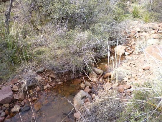
There is water before you get to Reavis Ranch in a little creek near Windy Pass, but it is only seasonal as far as I know. If it has rained within the last week, there will probably be some water in it. Here's the water source near Windy Pass when I went last March:

windypass

Otherwise, yes – it is a dry hike all the way to Reavis Ranch where a large, cold stream will come from nowhere. Reavis Falls is a little shorter hike that starts from the same trailhead. There's an unofficial trail (the beginning of which is marked) to the falls:

http://hikearizona.com/decoder.php?ZTN=99

Chad B BPL Member
PostedJan 28, 2014 at 7:53 am

Good suggestions so far. If your vehicle can make it to Rogers Trough TH, approaching Reavis Ranch from the south is a nice hike. I believe it's around 7 miles one way. It makes for a good overnighter.

Lot's of options in Sedona. Secret Canyon is a great area. There is usually water in the upper canyon, about 5/5.5 miles in.

Another option is Aravaipa Canyon Wilderness. You need to get a permit to enter either west or east entrance. The west entrance would be a closer drive. You spend a majority of the time hiking in the creek, so this time of year your feet are going to get cold. But it is a great area and one of the few places in AZ where you won't have to carry water.

Viewing 8 posts - 1 through 8 (of 8 total)
Loading...