Topic
2014 Bob Marshall Wilderness Open: Marias Pass to Monture Creek
Forum Posting
A Membership is required to post in the forums. Login or become a member to post in the member forums!
Home › Forums › Campfire › Hiking Partners / Group Trips › 2014 Bob Marshall Wilderness Open: Marias Pass to Monture Creek
- This topic is empty.
-
AuthorPosts
-
May 27, 2014 at 6:25 am #2106163
The shuttle drive is a long one, and I am sorry folks are finding it hard to manage. I just got back from my sisters wedding and will have a difficult enough time fixing things at work and getting myself ready.
I am not bringing a bike, though there is at least one decent way to complete this route with one. The snow and mud make May a not ideal time for it. Still on the fence with snowshoes, and more than a bit nervous about what the packrafting will be like.
M and I will probably make it to the Snowslip for dinner between 730 and 800 Friday night.
May 27, 2014 at 6:08 pm #2106332How does this work if there's no BPL carpool? I honestly have not done a hike in an area this remote before. Can I expect to be able to hitch up to catch a ride with you, Dave? I'm on a schedule getting back and having to fetch my car from Marias would make it much more difficult.
Sorry to sound like a newb. My hikes are almost always loops b/c I so rarely have someone able to shuttle.
May 28, 2014 at 7:09 am #2106487It works by being a pain; no other way around it.
Hitching from Monture up to the Flathead is quite doable, but things being what they are these days I'd leave yourself all day Friday if possible. The dirt road from the TH back to pavement doesn't get a ton of traffic, but 200 and 83 are both well traveled.
I'll send you an email Spelt.
May 30, 2014 at 7:55 pm #2107359Good luck with your routes tomorrow. Kate and I just wrapped up a 75 mile loop in the Bob this morning. We found snow before 6000 feet and more than 8 feet deep at 7700 feet. The water levels were epic this week making stream crossings hairy. We had the opportunity to see a lot of wildlife including a huge black bear.
We spent an entire day above snow line and half of that time in crampons, but never needed snowshoes.
Jun 3, 2014 at 8:13 am #2108359I'm out and back home. More snow than I expected and a lack of legs to go fast enough through it had me 7 miles behind schedule the first day, and more of the same and scouting (and not running) some big rapids on the N Fork Sun had me 20 behind by the end of day two. Lacking the time, food, and most importantly inclination to push through and finish on that 4+ day schedule, I paddled out Gibson yesterday morning.
Quite the contrast to last years low snow and low water. I wore snowshoes for close to 10 miles straight going over Badger Pass. Strawberry Creek where most crossed it last year was absolutely not doable on foot. Sun River pass, which had maybe 9 linear feet of snow last year, had perhaps 3/4 of a mile all told this year.
Even truncated, this was a great route. Most of the first day was all new to me, and made for enjoyable walking and snowshoeing. The North Fork of the Sun between Wrong Creek and Headquarters Creek might be my new favorite stretch of floating in the Bob. Going over Sun River pass I saw a big bachelor herd elk who already had impressive antlers in full velvet. The whole Sun River valley was greener than I've ever seen it, with flowers everywhere.
It'd be easy to say that I should have been more realistic, packed a bit more food, and given myself a bit more time. Dealing with fairly challenging and potentially hazardous conditions on a tight schedule was not enjoyable. Then again, I only learn best by doing. As my own inclinations change 30+ mpd and the suffering which goes with it is less and less compelling. I've been there and done it, and have no need to reprove that I can still do it. I'm not sure what and where the future of the BMWO will be, but I imagine it will involve some way of de-emphasizing the more severe athletic aspects while still encouraging folks to get out in challenging conditions.
Jun 3, 2014 at 8:15 am #2108360Btw four of us showed up Saturday morning. Tanner and Tyler (?) from Missoula and Bozeman headed east; not sure of their route. They were raftless and snowshoe-less and hoping to finish on Tuesday or Wednesday. Spelt was following a route similar to mine, and had a raft. His car is still in our parking lot so he's still out there somewhere.
Jun 3, 2014 at 3:36 pm #2108506"Dealing with fairly challenging and potentially hazardous conditions on a tight schedule was not enjoyable… As my own inclinations change 30+ mpd and the suffering which goes with it is less and less compelling… I'm not sure what and where the future of the BMWO will be, but I imagine it will involve some way of de-emphasizing the more severe athletic aspects while still encouraging folks to get out in challenging conditions"
I had a similar reflection over the last few days. I had gone down to Tahoe to attempt the THT on an aggressive schedule, but after surveying the area ultimately decided that I wouldn't have fun (especially with lingering snow) at that pace over that distance. I could have enjoyed the shorter Western States Trail, but it was full of poison oak. On the drive back I kept wishing I could have made the BMWO logistics work.
My suspicion is that events like these will settle into a ~100 mile format. That seems short enough for people to sustain ambitious paces (if inclined) and for people to take the time off, but long enough to offer obstacles and challenge. For my part, I'd love to tour in new areas that, honestly, I might never motivate myself to visit otherwise.
It also occurred to me (it's a long drive between Tahoe and Seattle, so a lot of things occurred to me) that if an event is truly not a race, then you only need to have one fixed location, either beginning or end, as is done in the TGO Challenge. For instance, start at Benchmark and end anywhere along Highway 2 (or the other way around).
Anyhow, the topic was on my mind. I'll be at the Packraft Roundup next month if you want to discuss.
Jun 3, 2014 at 4:14 pm #2108516David,
thanks for the update. the main reason that I failed to show this year was because I couldn't get the math to work out on the distance, conditions and my window. The amount of food that would have needed to carry would have weighed me down and further slowing me down. I definitely would have liked to do a return trip, maybe next year. Look forward to seeing the full report.Jun 3, 2014 at 6:07 pm #2108564John, I agree on your distance thoughts, and like the idea of a fixed start but only a certain zone for the end. See you in July. Should still be plenty of water!
Jun 4, 2014 at 9:00 am #2108750Dave, I'm glad you made it out safe and had what sounds like a good experience. Given that you saw so much snow on Badger Pass I wonder what it would've been like down by Hahn Creek or Limestone Pass. A good reminder that we got pretty lucky with the conditions last year especially given what you said about Strawberry Creek. Out of curiosity, did you get a look at the crossing of the South Fork Two Medicine? Based on my estimates, that would've been the most difficult crossing of the route that I had planned, if I had been able to make it this year. I definitely feel a strong pull to come back to the Bob after the great experience last year – maybe a packrafting trip in July or August would be a more civilized undertaking.
Fingers crossed for Spelt and the other guys. I'm looking forward to seeing some pictures.
You still thinking about doing the Sierra High Route sometime?
Jun 4, 2014 at 9:55 am #2108769I followed the CDT up above the S Fork Two Med precisely because the lower crossing at the powerlines would have been a serious problem. In addition to being too deep to ford there, the river is in a narrow gorge and swift enough that boating across would have been not especially safe. The payment was snow up on the CDT. I left the trail before Benson Creek to avoid more snow and buskwacked straight down to the Two Med, at which point it was a reasonable thigh deep but swift ford at a braided section.
My plan for further south was to go over the Dry Fork divide and go up Canyon Creek and over into Monture at Trail Creek (name might be wrong). I know from previous experience that Limestone holds a lot of snow, and even worse, the trail on the west side down to Monture goes through steep north facing trees with lots of tedious, snowy traversing.
I think to find a non-swimming ford of Strawberry would have been a 6-8 mile roundtrip detour if you didn't find a good log sooner.
Jun 4, 2014 at 10:35 am #2108791
Trip Plan
8:00am Start at Marias Pass
Run Hwy 2 ditch to Skyland Road and up to Morrison Cr. Trailhead
Morrison Cr Trail to Big River Trail
Big River Trail to Schafer Meadows
Schafer Meadows up Dolly Varden to Pentagon Pass
Pentagon Pass to Pentagon Cabin
Pentagon Cabin to Wall Cr. then to White River
White River down to South Fork of the Flathead
South Fork of Flathead to Youngs Cr.
Youngs Cr. to Hahn Pass
Hahn Pass to Monture TrailheadPurple line shows planned route. (Included an optional route toward the beginning)
Red line shows actual route.
117 proposed total miles.
Planned to be out Monday Night or Tuesday.Strategy
Light weight packs with 10 lbs base weight 9 pounds of food.
1 Liter water bottle with 1 Liter backup
35 plus miles a day but reevaluate if lower mileage than 30 a day.
Try to jog easy sections of trail
Utilize Two man river crossing techniques to fords streams
Time Constraint (Must be out by Tuesday)Trip Report
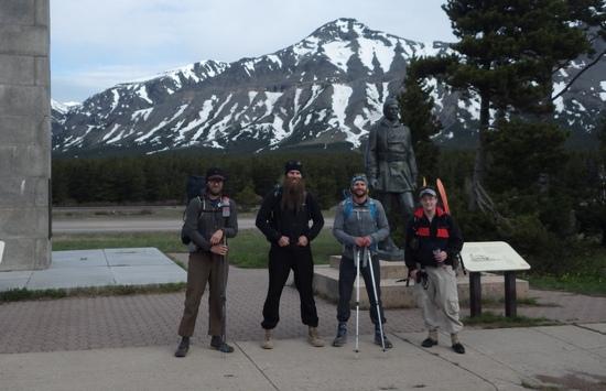
Day 1 Started at Marias Pass with a meet and greet of the 4 participants. Jog highway ditch then up Skyland Rd. to Morrison Cr Trail, reaching the trailhead at 10:45 am. High snow levels at the trailhead. 5-6 foot drifts with full snow cover of the trail. The trail was hard to follow for the first 3-4 miles. Snow for the first 7 miles slowed the pace. We crossed Morrison Cr. 3 times using the two man crossing technique and it was needed. A one man crossing would have been tough.
Final Crossing of Morrison Cr.

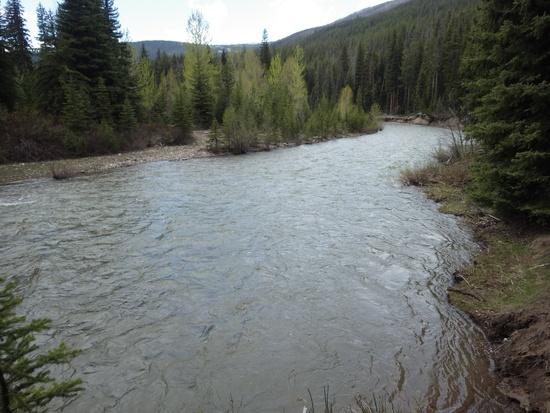
Trek up Big River Trail to Schafer Meadows with an arrival time of 4:00pm. Signed the logbook and swam the Middle Fork River to continue up Dolly Varden Cr.
Schafer Meadows Airstrip
Middle Fork Conquered

Up Dolly Varden hoping to cross the Pentagon Pass to make it to the cabin, we realized that we would run out of daylight nearing the top of the pass making the climb and descent dangerous.
Up Dolly Varden Cr.

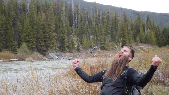
We would have liked to make the cabin (45 mile mark) but were happy with a 35 mile day, confident we could make up some of the lost miles the next day. So we decided to hold up at 5400 feet (snow line) to wait for morning. As we set up camp we looked down upon the large Grizzly tracks that had just passed through and slept well. Low temp for the night was 34 just before daybreak with a slight drizzle.
Grizzly Tracks
Dolly Varden Near 5400 Feet
Day 2 Woke up and headed toward the pass. Snow travel again made the trek slower than planned especially toward the top of the pass where varying snow conditions had us transitioning from kicking toe holds in frozen snow to swimming waist deep snow holes.
Pentagon Pass
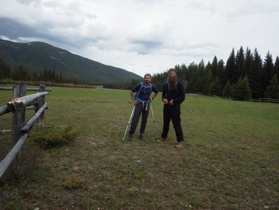
We glissaded down the pass to the bottom. The snow transitioned with the lower elevation, becoming softer. Maybe a 1/4 mile down I broke through the snow layer and hit the front of my shin 3 inches above the ankle on a downed log. My body flew forward and I was lucky not to snap my leg. It hurt but I pulled my leg free and was able to keep trekking. There was allot more snow in the Pentagon drainage than expected. 1-2 miles later and warmed up, my leg started to swell and lock the ankle motion. I fought this and later a left IT band issue all the way to Pentagon Cabin. At the cabin we made the choice to use the bailout knowing that the leg was not going to get better and we were not going to be making the times we wanted in the coming days. With work and worrying family members, we could not afford the risk of not getting out in the allotted time frame.
Pentagon Cabin
It was a good choice but a tough one. My Bob Marshall team member Tanner K. was in better shape and physically doing fine so it was a hard decision to make. We made the call to bailout to Spotted Bear Ranger Station another 25 miles away. We headed down the trail to Dean Creek. The crossing was a tough one. The situation only offered one crossing spot with more than a few danger areas. The crossing is just a bend away from the confluence of the now raging Spotted Bear River. We probed the depth as far out as we could reach with the trekking pole and determined it was worth a shot. We crossed again using our two man technique. The current was right at the upper levels of what we could hold off but we made it without incident and continued the route.
Mean Dean Creek

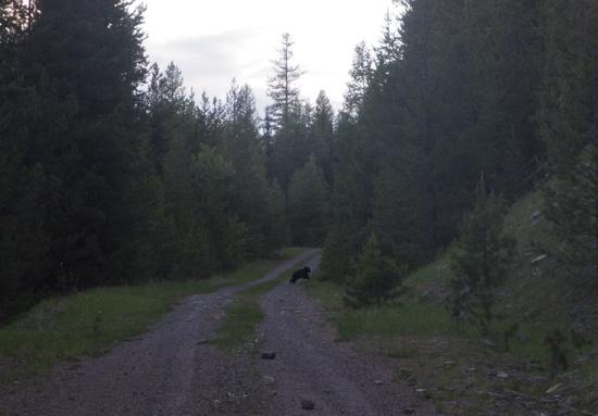
5 miles along we were at the trailhead looking at 15 miles more of gravel road travel to the Ranger Station. My new injury and left IT band made the walking pain extreme. But the pain was relieved after seeing our friend the black bear.
Black Bear

Later in the bailout my right IT started to go out, I think from the added strain of hobbling with the injury for so long. 10 miles from the Ranger Station just after a 10 minute food break my knees locked up and it was over for the night.
Knees and Ankle are Toast
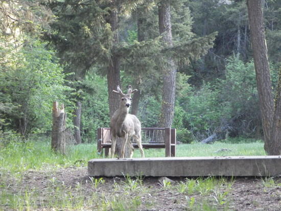
We spent the night at the Beaver Creek Campground. Low temp 40.
Lots of Mule Deer at Campground
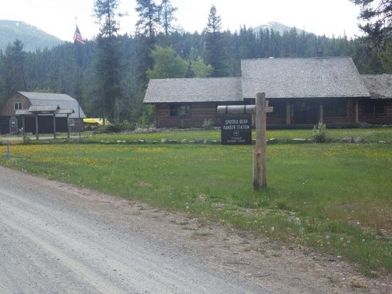
With a decent nights sleep and lots of IBuprofen, I was able to get the knees moving again and we pushed on 10 miles to the Ranger Station. We caught a ride out to Whitefish and the trip was over.
Spotted Bear Ranger Station
Two Waters Please
After Thoughts
Snowshoes and a raft would not have helped on this route. The snow travel on this route was tough and doubled your work effort but you didn't sink far enough in to make snowshoes a great option.
The route was very doable but one miss step and it quickly becomes a different goal.
Ankle and foot swelling
Bad injury aside, More training on my part was needed. I was a 20 mile back to back man trying to do 40 mile back to back treks. It was doable but there would have been a decent amount of pain involved which gets you to the goal but not the fun way. My friend Tanner was physically ready and could have made the distance but I believe two people were needed on this route to do the streams with relative safety and we had at least 2-3 more to cross to make the finish.
We were burning around 6000 calories a day to make the mileage we did. It was interesting to note that we burnt 120 on an average 1 mile trail but adding snow bumped it up to 270-300 calories per mile.
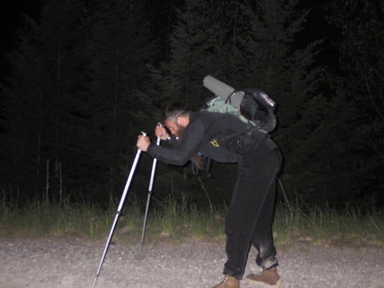
I am not a trekking pole hiker but they were a must have for me to get out the way I did. I had to borrow them from Tanner. I really saw the benefits of their use, watching him use them. It was a sealed deal after absolutely needing them to hobble out 30 some miles.
All this aside, we can't wait until next year. If no one makes it this year the two points should remain the same. It is an amazing test of skills and training that is not offered in this season set anywhere in Montana. Great opportunity to perform in an environment that is challenging. You dictate the pace so you also dictate the miles per day you think your body can handle.
Logistics would be nice to hammer out to make it easier on other people who are not from the area. Maybe everyone meeting at the end point and a shuttle to the start could be an option. That way your ride is at the end and there is more interaction with the participants. Maybe meet on a Friday afternoon and start on a Saturday morning with lodging options Friday Night near the start. Whether that option is a field or actual cabin / motel it would be nice to gather.
The BMWO must live on. It is a premier event in an amazing place that will really test the skills and abilities of multi-level participants.
We hope to hear from Spelt.
Jun 4, 2014 at 10:51 am #2108795Bravo Adam and Tanner! Thanks for the pictures and the report. It makes me shudder to think about breaking a tib/fib out there this time of year. Care to elaborate on your two-man river crossing technique?
Jun 4, 2014 at 11:41 am #2108815Awesome job Adam and Tanner. Thanks for posting, and sorry Adam for mis-recalling your name.
Jun 4, 2014 at 12:10 pm #2108826Two Person Setup
The two person technique is used to cross streams that would wash out the legs of a single crossing person by giving stability to each crosser, breaking the current load and utilizing more points of contact:
Each person faces the other grabbing the others arms just below the shoulders. The largest person is the upstream side. In this position you side step and enter the water. You want to take a 45 degree cut across the stream so you don't have to fight the current every step taken to get across. Let the current help you make that small step across and down. One person takes one step at a time never crossing the feet. Calling out things like "Stepping . . . I'm Stable" and then allowing the other person to do the same are key to crossing high volume deeper flows.
The down stream person needs to lean forward and push on the upstream person to keep them from bending with the current. Like holding up a wall. The Down stream person will have allot less flow on the feet so they should make sure they are stable before the upstream person steps.
Tips and Things to consider when crossing cold streams.
Try to find a spot where the stream or river forks into different channels. You want to split up the CFS of the stream as much as you can. When we crossed the Middle Fork we decided to cross a little further down from the actual trail where the river split, dividing it into two smaller sections.
Make sure the other side is gradually getting shallower and has an easy exit. You don't want to try to pull yourself out of a cutbank. Make sure of a secondary exit should you miss the first one.
The water is cold and you need to get use to it. Its tough to do but you need to get wet before you get wet. When you get thrust into full submersion your blood races away from your extremities and into your core and you hyperventilate. Add extra heavy breathing due to panic and its bad news. Get use to the temp as much as possible and your breathing will be calm.
You can only spend about 8 minutes total in that water so make sure there are immediate options on the other side. More than a minute in the water was numbing.
Swim together. Both people need to be in the water together in-case something goes wrong with the other person. You don't need your partner on the beach panicked and then entering the cold water trying to help.
When in doubt just don't do it!
These techniques and suggestions are just things that we decided on as a team to mitigate some of the risk of the crossing and cold water. We are learning just like everyone else so don't take this information as gospel. There might be far better techniques out there but these seemed to make sense and worked when needed for us.
Jun 4, 2014 at 12:17 pm #2108831Hey David, no problem! Thanks for putting on an awesome event and making this possible. My friend Tanner got me into it and we have followed all the Opens for a few years now hoping to participate. It was an amazing experience. We learned more on this one event than any other trip taken.
Jun 4, 2014 at 2:06 pm #2108877"We learned more on this one event than any other trip taken."
That's what it is all about.
Edit; my report and photos: http://bedrockandparadox.com/2014/06/04/the-2014-bob-marshall-wilderness-open-it-will-never-be-the-same/
Jun 4, 2014 at 9:03 pm #2108990Nice effort everyone! Sounds brutal and beautiful. Anyone hear from Spelt?
Jun 5, 2014 at 9:22 am #2109085I got an email from Spelt. He ended up bailing to East Glacier and was able to Amtrack back to Whitefish and retreive his car from our house while I was at work yesterday. So everyone is out fine, and no one got within 50 miles of the finish!
Jun 7, 2014 at 9:10 pm #2109705Just a quick note to say I am working on a report but between moving and my copious notes it will emerge slowly. I hope to have the first part up by Tuesday. Dave,Adam,Tanner,great to read your accounts.
ETA: the great thing about self-imposed deadlines is you can watch them whoosh by w/o TOO much guilt…
Jun 12, 2014 at 1:22 pm #2111040A thought for 2015 for folks to consider: Gibson to Skyland TH, starting on March 28th.
Jun 13, 2014 at 2:13 pm #2111351That sounds…. cold!
In the plus column: there wouldn't be the usual back-and-forth about whether to pack snowshoes.
Jun 13, 2014 at 3:45 pm #2111373David,
Do you sitting around thinking about how to increase pain and punishment? That would be a true winter trip. I'm guessing it has a good ski option?Jun 13, 2014 at 4:21 pm #2111377That would be smack in the middle of my spring break, the first time I'd be able to do this event.
On the other hand, I don't know a damned thing about skiing.
Jun 13, 2014 at 4:43 pm #2111384Malto, I can't think of a good hiking route. ;)
Craig, it's just like surfing, only with two sticks and two poles.
-
AuthorPosts


- You must be logged in to reply to this topic.
Forum Posting
A Membership is required to post in the forums. Login or become a member to post in the member forums!
Our Community Posts are Moderated
Backpacking Light community posts are moderated and here to foster helpful and positive discussions about lightweight backpacking. Please be mindful of our values and boundaries and review our Community Guidelines prior to posting.
Get the Newsletter
Gear Research & Discovery Tools
- Browse our curated Gear Shop
- See the latest Gear Deals and Sales
- Our Recommendations
- Search for Gear on Sale with the Gear Finder
- Used Gear Swap
- Member Gear Reviews and BPL Gear Review Articles
- Browse by Gear Type or Brand.
