Topic

Accuracy or otherwise of GPS

  • This topic is empty.
Viewing 25 posts - 1 through 25 (of 36 total)
Stuart R BPL Member
PostedJul 28, 2013 at 9:04 am

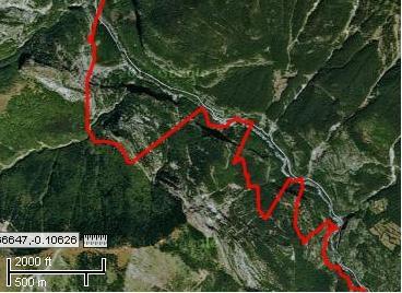
Here are a couple of examples of wildly inaccurate GPS tracks, recorded using a Garmin Dakota. The first is in the Ara Valley, northern Spain. This is a deep valley and my true track was along the visible track by the river, so I am not too surprised by this.

Ara track

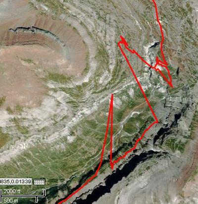
This second one is in the Ordesa Valley, later the same day. Altho' the Ordessa is also a deep valley, I was not in the vally bottom, I was high up one side on the Faja del Pelay path. The deviation from my true position was 1km at one point!

Ordessa track

HkNewman BPL Member
PostedJul 28, 2013 at 10:34 am

Sometimes the signals get reflected momentarily or while in a certain terrain feature. Not much one can do about it. Taking a GIS survey class with the latest in survey-grade equipment, one group had a couple readings go completely off while measuring square beach bungalows. At home or in an office, one can just adjust using an aerial photo or blueprints (or go back to get better readings if needed), but in the field, you may want to bounce errant readings against previous readings or a paper map using the same coordinate system.

Bob Gross BPL Member
PostedJul 28, 2013 at 10:57 am

There are lots of things that a user can do that contribute to GPS inaccuracy, and most of the time the user is completely unaware of what is going on. You don't say how the GPS receiver was carried or how its antenna was oriented. That is the typical problem, especially since most users don't even know where the antenna is located within the receiver.

When you get into "challenging terrain" like a narrow canyon, some really interesting things happen. Your receiver might be tracking with satellites #1-6, and all of a sudden you pass under heavy tree canopy. All of a sudden your receiver is forced to pick satellites #4-7, and due to the sky geometry, the position fix will have big errors. Then when you come out from under the canopy, your receiver goes back to satellites #1-6. All that can cause the track to appear as you've shown. When you get into the canyon, you can get multipath interference. That means that the signal may not be coming straight down from a satellite. Instead, it might be bouncing off reflective surfaces on the other side of the canyon, then bouncing into your antenna. All of that bouncing adds extra distance to what the signal is traveling, and that means extra time in error, and that means inaccuracy in the position fix. Your tracks look like this.

What you want to do is to watch the EPE (estimated position error) statistic which is available on some GPS receivers. By a variety of means, if the EPE suddenly goes from 15 feet to 100 feet, that is a sign of terrible errors hitting the receiver, and it might be from multipath or something else. I own one 15-year-old receiver that shows EPE easily, so I prefer it over my 5-year-old receiver that hides the EPE display.

Lastly, there are GPS blunders to consider. Due to the way that GPS works, there may be two position solutions, and the GPS receiver is designed to pick the one that is more logical. Typically one possible fix is illogically high in space, or going at an extreme velocity, or on the other side of the continent from where it was last used, so the receiver throws that out and picks the logical position. Once in a great while, it picks the wrong one. If you see that happening, you see some crazy position or speed. In general, you shut the receiver down, count to ten, and then start it back up. When you get a new fix some seconds later, typically the illogical position has faded out.

–B.G.–

PostedJul 28, 2013 at 11:02 am

Sooooo…., one has to ask –

Is this a reality that one could expect with a SPOT, ACR, or FastFind personal emergency beacon?

Bob Gross BPL Member
PostedJul 28, 2013 at 11:26 am

These SPOT, ACR, or FastFind beacons do not have GPS as their primary function. Therefore, they do not have the most sophisticated GPS receiver onboard, so they should be just as susceptible to multipath as the next model. Plus, they typically offer the user very little in the way of GPS information display, so hoping for EPE is out of the question.

However, you don't need to get a position fix accuracy of 15 feet in order to get a good emergency call out. If a helicopter were coming for you, if you could get within 200 feet, that would be fine. I believe that is why some of these devices have an auxiliary beacon for 121.5, and it gets used just for the final helicopter approach to the LZ.

That is another reason why emergency dispatchers tend to monitor an emergency beacon after the initial call ends. They try to watch the transmitted GPS position to see if it is moving. If it moves consistently along a trail, then that means that it was probably a false alarm. If it wanders randomly around the initial point, then that is the normal pattern for a GPS receiver. It it suddenly jumps around dramatically, that means something else. If it suddenly goes off the air, then that is something else entirely.

–B.G.–

Jerry Adams BPL Member
PostedJul 28, 2013 at 12:06 pm

I've seen similar error with Garmin 60CSx. The path on the GPS parallels the true path, offset by maybe a fraction of a mile, then it snaps back to the true path.

It doesn't happen that often.

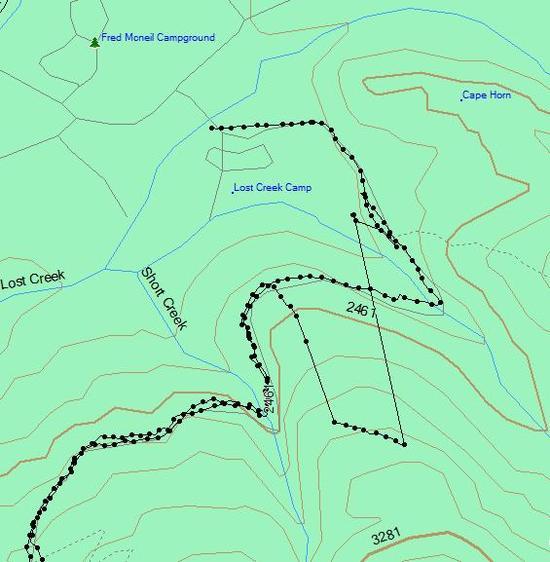
For example, I walked up road and then back, but for about 10 minutes it was offset 0.3 miles, then it took a couple minutes the get back to the tru position:
lost gps lock

Bob Gross BPL Member
PostedJul 28, 2013 at 12:18 pm

"It doesn't happen that often."

Jerry, this would be an interesting experiment. Walk the same trail the same way several times, perhaps spaced out 1-2 hours apart, and compare the track logs.

If it is a multipath problem caused by reflections off canyon walls, then it may reoccur in the same place.

Also, if you see your apparent position jumping around this way, make a note of the EPE and the satellites in view at that moment. You may see a trend, like it may happen when there are fewer than five satellites in view, or something like that. Or, it may happen only when you are walking east and west.

EPE is not a number that you need to take to the bank, but a high number simply alerts you that something fishy is going on.

–B.G.–

Jerry Adams BPL Member
PostedJul 28, 2013 at 1:23 pm

I didn't look at estimated error

I suspect it has to do with satellite position and maybe steepness of canyon

Other times I've walked there it was okay

Same thing has happened other places

More common is just that it loses lock for a while and doesn't display any position

Bob Gross BPL Member
PostedJul 28, 2013 at 1:42 pm

"More common is just that it loses lock for a while and doesn't display any position"

Most GPS receivers attempt to get an overdetermined position. That means that they receive multiple satellite signals and try to squeeze as much information out of the maximum of signals, whereas they really only need about four signals to work. When they get less than four signals, they just drop out to null data. Right at that instant it is nice to look at the satellite signal strengths/status to see what is going on. That is why new receivers 15 years ago used to display this stuff prominently. Then the software guys got busy and cooked up some new algorithms. The marketing guys got busy and suggested that they just suppress lots of the satellite status display, and that it would make the receiver seem to be having fewer dropouts and problems than it really did.

Of course, you can't permanently hide that kind of crap. I've spent large amounts of my professional life analyzing GPS performance data, and I've seen where most of the bodies are buried.

Still, you can't blame it all on the GPS receiver. I recommend for each GPS user to learn exactly where the antenna is and to know how to orient it mostly upward without your head hovering above it. That is not required all of the time, but if you aren't watching the EPE closely, you don't really know what it is doing to you. When I am out on a backpacking trip, I seldom get my GPS receiver out more than once a day. When I do, I turn it on, set it out on a rock, eat a snack, and then look at the display after a minute or two.

If you get totally serious about GPS accuracy, you will get a choke ring antenna. That is what you normally see used by a survey crew, and it looks a bit like a flying saucer on a pole. A choke ring antenna completely blocks multipath interference, but it is a lot to carry around.

–B.G.–

Jerry Adams BPL Member
PostedJul 28, 2013 at 2:12 pm

Good info Bob

I carry my GPS in my pocket, on all the time. I take track everywhere I go. Then I can tell how far I went, go on same route some other time,… Just to be geeky perhaps.

The reception in my pocket, with unit next to my leg and sort of pointing forward isn't as good as if I take it out and hold it in front of me with antenae pointing up. I think maybe my leg blocks reception, or maybe it's antenae pointing up rather than sideways.

When I pull it out of my pocket, the bars get bigger.

When I first turn it on, it requires better reception. In my pocket doesn't work so good. If I set it on rock or whatever it acquires the satellites better. Then I can put it in my pocket. It remembers where the satellites are. Doesn't require as good a signal once it's acquired, to update the position.

If it loses lock, I'll pull out of pocket and hold it in front of me until it re-acquires.

Bob Gross BPL Member
PostedJul 28, 2013 at 2:29 pm

"It remembers where the satellites are."

Yes and no. Mostly no.

It can remember which satellite signals it had most recently received, and it likes to start acquiring with those if they are present. However, remember that GPS satellites are not at fixed positions in space. They are flying oblique polar orbits. So, think of them as coming up out of the southwestern horizon, overhead a while, and then gone down over the northeastern horizon. Then some are northwest to southeast. But they are in a meshed grid all over the sky, constantly flying, constantly shifting. The almanac information tells the receiver which satellites are most likely to be found overhead, but the receiver really doesn't know what it is going to get until it has been receiving for a bit.

There is some tweaking of the current satellite orbits, and that update information is contained within the downlink signals, but your receiver typically doesn't have that until it has been on continuously for some minutes. That just tends to make your position accuracy better than the initial fix.

On the average, the best place for GPS reception is probably in the highest pocket in your backpack. There, it won't be shaded by any body parts. Unfortunately, that is not a very convenient place if you like to watch it.

–B.G.–

jscott Blocked
PostedJul 28, 2013 at 7:09 pm

Jerry, I have an older model Garmin 60csx. I carry it on a clip, that came with my model, on my pack shoulder strap. I love this clip because it's really easy to unclip the unit, use it, and clip it back in. In fact I loop the lanyard around my shoulder strap and still have enough leeway to read the unit, without having to worry about losing/dropping it. No need to remove gloves–if they're not so thick as to make toggling impossible. Also, it keeps the antennae pointed up, fairly unobstructed.

Jerry Adams BPL Member
PostedJul 28, 2013 at 7:13 pm

I used the clip some, then a couple times it came unclipped, so I just started putting it in my pocket. Yeah, reception much better.

Bob Gross BPL Member
PostedJul 28, 2013 at 7:19 pm

Normally it doesn't hurt to have a GPS receiver inside a fabric cover, pouch, pocket, or plastic bag. Ordinary nylon and similar fabrics are transparent to the GPS downlink signal.

On the other hand, if you loaded up that fabric with a fraction of an inch of ice, snow, or water, it might impair the signal. Normally a summer backpacker can't get that much signal impairment out of a little rainwater.

–B.G.–

Jerry Adams BPL Member
PostedJul 28, 2013 at 7:47 pm

Just fooling around on patio, looking at "the bars"

The bars were bigger when I held GPS a foot away from my body. Didn't make any difference whether it was pointing up or sideways, either North, South, East, whatever.

Bars were bigger when I set it on ground (concrete).

Bars got smaller when I held it against my body – in pocket, out of pocket, where it would be if attached to shoulder belt, pointing up, pointing sideways.

My body must be interfering with signal. Doesn't matter if it's in pocket or attached with clip.

Bob Gross BPL Member
PostedJul 28, 2013 at 7:59 pm

Jerry, do whatever you need to do to get the maximum height of the signal strength bars. It should still function with short bars, but the accuracy might be poor.

The concrete observation doesn't surprise me a bit. Generally, concrete represents a good signal ground, and the receiver antenna slightly away from that should work good.

Your body can block the signal, but it does not normally interfere with the signal (meaning it doesn't generate any conflicting signal). Your body is mostly water, and water blocks the signal.

I understand how everybody interprets the signal strength bars. Actually, it is not signal strength. It is the degree of match in the digital coorelators that are looking for the particular random patterns of the various satellite signals. It's just easier to think about it like signal strengths.

I used one old GPS receiver on the summit of a nearly-7000-meter peak that was the highest place in the entire Southern Hemisphere. Obviously I had nothing blocking the view of the sky, so I had a maximum number of satellite signals hitting there with nearly maximum strength. Its calculated summit altitude was only one meter off the official surveyed altitude, so I guess that is what you call good results.

–B.G.–

jscott Blocked
PostedJul 28, 2013 at 8:29 pm

"Unit came unclipped." That's why I use the lanyard as back-up.
Actually I've been pretty impressed with how robust that little clip is. I like this arrangement for ease of use, although taking it out of your pocket is pretty darn easy too. I also guessed that I would get a better signal this way, but I never seriously tested this; just an intuitive guess. I always got a good signal with the thing in my pocket too. I mean, the gps unit in my pocket.

Keeping the unit in my pack is sort of a hassle if I need to reference it a lot.

Rex Sanders BPL Member
PostedJul 28, 2013 at 10:15 pm

Bob,

Could a GPS receiver see big jumps in accuracy/position as the geostationary WAAS satellites go in and out of view?

What is WAAS? Quoting from the Garmin web site:

“Basically, [WAAS is] a system of satellites and ground stations that provide GPS signal corrections, giving you even better position accuracy. How much better? Try an average of up to five times better. A WAAS-capable receiver can give you a position accuracy of better than 3 m, 95 percent of the time.”

However, Garmin might be overstating the case. Since Selective Availability was turned off in 2000, GPS without WAAS is good for about 2.5 meters, with WAAS about 1 meter.
http://en.wikipedia.org/wiki/Wide_Area_Augmentation_System

WAAS satellites are in geostationary orbits over the equator at 98° W, 133° W, and 107.3° W. WAAS is effective over most of North America only.

— Rex

Bob Gross BPL Member
PostedJul 28, 2013 at 11:11 pm

Rex, I suppose that anything is possible, but I don't think so.

"Try an average of up to five times better" does not mean five times better.

For one thing, if a GPS receiver is WAAS-enabled and was actively using WAAS for correction, and then if WAAS became blocked, the receiver ought to show the user some kind of indication that WAAS corrections were no longer active. At a minimum, the receiver's EPE should go to hell, but that is difficult to see on some GPS receivers.

Also, if your GPS receiver has a view of six or eight normal GPS satellites, then I can't think of any good reason why WAAS would be blocked unless there was an obvious tree blocking that central part of the view of the sky.

And then, the non-WAAS accuracy numbers you quote seem overly optimistic by a little bit. I always think of general maximum horizontal position accuracy of 15 feet, but that assumes great view of the sky, good satellite geometry, etc.

All of this is stating the maximum accuracy, primarily for the space segment, and this assumes that you have a perfect user segment (receiver), but this is seldom the case. A civilian aircraft can have a GPS receiver with some pretty impressive performance with a high quality atomic clock, and that includes a great antenna. By the time you get down to some eight-ounce handheld device running on a small battery, you may have less performance (at least shown as horizontal position accuracy).

Now, as it turns out, the primary purpose behind WAAS is not to augment the horizontal accuracy, although it does do that. The primary purpose is to augment vertical accuracy. When you are trying to land a jetliner in Category 3+ fog, if you are off by 50 feet to the side, you will still land OK, but it is much more important to know how far off the deck the nose gear of the airliner is. That is where WAAS wants to give you just a few feet of vertical accuracy. Of course, all of this is totally irrelevant to a backpacker on foot.

If you really really need some accuracy, then go get yourself a DOD secret clearance, buy yourself a mil-spec GPS receiver, plug in the crypto codes, and receive GPS L1 signal (civilian) plus GPS L2 signal (military). Now you have real accuracy. I digress.

–B.G.–

Stuart R BPL Member
PostedJul 29, 2013 at 1:30 pm

I carry the GPSr in the top lid pocked of my pack. You're right about the antenna, I have no idea where it is, somewhere inside.
Since I do not regularly look at the GPSr, I do not know what the EPE was at the time.

The track log includes elevaton data. The odd thing (to me) is that even when the horizontal accuracy is way out, the elevation data still has a good correlation to my true position (but not to the reported horizontal position). So, comparing the GPSr elevation with an altimeter would not help determine whether the GPSr data was good or not.

David Thomas BPL Member
PostedJul 29, 2013 at 2:41 pm

Bob may well know, but if I was writing GPS code, I'd look to identify the mode of transport (2 – 4 mph is pretty clearly hiking or maybe sailboat or burro) and therefore take a longer-term average before reporting altitude.

Ideally, you could enter different modes – hiking, driving, alpine skiing, etc – so the appropriate data smoothing could be done. Some units (and especially mapping software) insist on putting me on the highway, when I'm actually hiking a parallel path. Someday I should try driving on the wrong side of the highway to see if it is using my direction-of-travel to locate which side of the divider I'm on.

Bob Gross BPL Member
PostedJul 29, 2013 at 2:52 pm

I believe that some GPS receivers have a user-set mode (my newest one does), and then it runs in that mode until set to something else. It would be nice if it could guess the correct mode on its own, but I think that would have problems. I find myself driving some road that was built three years ago, but the GPS mapping database was finalized eight years ago, so it shows me speeding across open desert at 65 mph, completely unlocked to any known road.

You can get better operation if you team the basic GPS receiver up with an inertial guidance nav system that uses gyros. That's what subs use.

David, we could put you to work writing code, but then I have more respect for you than that.

–B.G.–

David Thomas BPL Member
PostedJul 29, 2013 at 3:39 pm

>"David, we could put you to work writing code"

And I'd be killer at 6502 assembly language and even more so at machine language (my stuff really had to twiddle the bits precisely), but I'm lousy at anything in the last 100001 years.

What I want someone to do with GPS is to create a global or a car-specific database of road slope and speed limits for the purpose of more intelligently managing a hybrid car's battery storage. As you approach your parking spot on the top of a hill, it should aim to somewhat deplete the battery, because the first thing you will do is regenerative braking. If you're 40 meters from a speed-limit reduction, delay kicking in the gasoline motor because you'll be slowing soon anyway.

And a more universal automotive app: Have a programmable cruise control mode. Whether from a database of speed limits, plus your personal preference "exact speed limit", "speed limit +4 mph", etc; or by storing your own driving pattern (which could incorporate lower speed in turns or fuel-saving speed reductions while cresting hills and gathering more speed in the valleys).

Heck, I'd be thrilled by a dial on the cruise control that varied from 100% constant speed / 0% constant throttle setting to the reverse. I'd let my speed vary some in return for the higher mileage from more constant throttle.

Bob Gross BPL Member
PostedJul 29, 2013 at 3:52 pm

"What I want someone to do with GPS is to create a global or a car-specific database"

I would think that you need to talk to Prius and the other hybrid car manufacturers, because they are probably into it. More likely, they are talking to some outside consulting firm to do the heavy code lifting. You could offer your advice for a fee.

Also, there are cars now that do all of this automatically, and you don't even need to manage the hybrid control. I think they are called internal combustion machines.

–B.G.–

Viewing 25 posts - 1 through 25 (of 36 total)
Loading...