Topic

Southern Sierra, mostly off trail

  • This topic is empty.
Viewing 24 posts - 1 through 24 (of 24 total)
Jim Sweeney BPL Member
PostedJun 28, 2013 at 7:47 am

Would anyone be interested in:

From Roads End (King's Canyon)
via Avalanche Pass trail to Sphinx Creek
Off trail to Sphinx Lakes Basin
via Brewer Basin and Longley Pass to small lakes below Thunder Moutain, aboveLake Reflection
Thunder Col to the upper Kern basin
Milestone Pass (highest point), Triple Divide Pass to Glacier Lake
Lion Lake Pass, Lion Rock Pass to 9 Lake Basin
on trail over Kaweah Gap, visit Precipice Lake, past Lake Hamilton, to Tamarack Lake
off trail to Lion Lake, down Cloud Canyon to Colby Pass trail to Roaring River ranger station
back over Avalanche Pass to Road's End

10-12 days, first two days slow, to acclimate.
Sometime in the next few weeks. This is a good year, as snow levels are low. Probably wouldn't run into snow much (except at Longley?)

Start date flexible.

We could stay together, or not, depending on how we were handling the altitude, regrouping and dispersing as our rhythms dictated.

I'll be cooking, sleeping cowboy in a bivy sack, base weight under 9 (inc. fuel).

PostedJun 28, 2013 at 12:22 pm

Hi there.

Sounds like a great trip. I did much of that area in a loop from Road's End to Mineral King and back a few years ago. One suggestion would be to use Thunder Pass to avoid dropping down into the trees. Tom Kirchner suggested it and it saved us a lot of time and effort; it was a little icy and funky on the north side even in September.

Report from my trip here:
http://www.backpackinglight.com/cgi-bin/backpackinglight/forums/thread_display.html?forum_thread_id=24319

Happy to answer any questions I can. It's a tough trek, and amazingly beautiful. You will feel like you are climbing talus forever as you head up the Milestone Pass!

Bob Gross BPL Member
PostedJun 28, 2013 at 12:48 pm

Don't you hate it when you start from Roads End and go over Avalanche Pass the first day?

–B.G.–

Jim Sweeney BPL Member
PostedJun 28, 2013 at 2:59 pm

Yes, Bob, that's a ton of climb, but will be stretching the altitude gain over two days, camping the first night where Sphinx Creek meets the trail, then getting to Avalanche's altitude the next day at Sphinx lakes.

And thanks very much for the suggestion and the offer, Dave. Will read your thread, and send you any questions I have.

Just took a look at Thunder Pass, or rather Thunder Mtn., which is what shows up on my map, but I'll do some research to better pinpoint the pass, and you're right, Dave, that looks much more elegant and direct.

Jim Sweeney BPL Member
PostedJun 28, 2013 at 3:33 pm

One possible enticement is that I'll be bringing a Sony DSC RX100, which so far seems to take really great pictures.

Jim Sweeney BPL Member
PostedJun 30, 2013 at 7:26 pm

Am sending in my application to SEKI tomorrow, 1st choice 7/19, 2nd 7/18, 3rd 7/17. As of today, according to the internet, each date had at least 5 available openings.

Will be carrying an EPIRB (Emergency Position Indicating Rescue Beacon), the ACR ResQLink, as there's a bit of cross-country in this trip.

Jim Sweeney BPL Member
PostedJul 5, 2013 at 10:50 am

SEKI has given me approval for the 19th.

If anyone is interested in this trip, there are multiple options he/she could do, short of completing the whole route:

Go to Sphinx lakes Basin, then return to Road's End– beautiful lakes, interesting cross-country once off the Avalanche Pass trail.

Cross Longley Pass, descend to Reflection Lake or East Lake, then head back on trail to Road's End.

Cross Kings/Kern divide at Thunder Col, then cross back via Milly's foot path, descend to Reflection Lake & back to Road's End.

Cross Milestone Mtn. Pass, intersect Colby Pass trail and head back on trail via Colby Pass, Cement Meadow, Roaring River, Avalanche Pass, all on trail, to Road's End.

Cross Triple Divide Pass, go down Cloud Canyon (off trail, but open country until the very end), rejoin Colby Pass trail at Cement Meadow, then on trail back to Roaring River, back over Avalanche Pass to Road's End.

Cross Lion Lake, Lion Rock, Kaweah Gap, then on trail over Elizabeth Pass, down Deadman Canyon to Roaring River, over Avalanche Pass back to Road's End.

Any one of these would be a great trip, and the options allow for differences in available time, how one is feeling, etc. Depending on how I'm doing, I may choose one of the shorter options myself. Or, if everything is going splendidly, and I have food & strength left, may investigate Glacier Ridge, after the homeward/second crossing of Lion Lake Pass.

Jim Sweeney BPL Member
PostedJul 5, 2013 at 3:31 pm

Thanks, Dave, that is a great thread. I was especially heartened by his description of the beauty of the upper Kern Basin, which I had been afraid might be somewhat austere.

+1 for Tom's appreciation of the Kern-Kaweah river valley. It is absolutely beautiful. I spent a night there once, after coming down from also wonderful country just above it to the south, on the flanks of Pickett Guard Peak, and wanted to take a rest day there, but didn't have time.

Kevin Garrison BPL Member
PostedJul 10, 2013 at 1:42 pm

Is your start date July 19th or Aug 19th? I just finished the JMT a few wks ago and I'm looking to do another trip. I'm committed to something in late July so this might not work. Sounds like a beautiful trip.

Jim Sweeney BPL Member
PostedJul 10, 2013 at 6:56 pm

Hi Kevin — it's July 19th. And bear in mind (see above) that this trip can be considered a set of nested loops, and one can choose longer or shorter loops.

Kevin Garrison BPL Member
PostedJul 11, 2013 at 8:40 am

:( July 19th does not work for my schedule. Bummed. I was really interested in exploring that part of the Sierras. Enjoy!

Jim Sweeney BPL Member
PostedJul 11, 2013 at 2:41 pm

Sorry to hear that. It would be great if you were able to segue right into another high altitude trip while you've still got your acclimation. I wonder how long that lasts?

On the other hand, I might not have been able to keep up with you!! Am kind of dreading the altitude and route finding which come so early in the trip! By the fifth day, things should be going well.

PostedJul 11, 2013 at 2:55 pm

That's going to be a great trip. The first day or two are going to be tough, as the trail up the Sphinx Lakes outflow is a lot of up, and then the offtrail up to Brewer Pass is a pretty serious project too. We made it from the lakes at the east base of Longley down to Road's End in a day, but you'll be doing it in the tough direection!

Have a safe trip, and be careful with all that talus out there (especially if you are going solo… and take a PLB if you are!).

Bob Gross BPL Member
PostedJul 11, 2013 at 3:12 pm

"It would be great if you were able to segue right into another high altitude trip while you've still got your acclimation. I wonder how long that lasts?"

Medical authorities have lots of opinions on this, but few hard facts. The general opinion is that adaptation to altitude will go away at about the same rate that it took you to gain it. That's kind of hard to understand, because there are a few of us who seem to adapt quickly to altitude each time we go up. Then it seems like it isn't lost very quickly on the way down.

What I did last year was to purchase a pulse-oximeter and use it. It's a tiny thing that just clips on over a finger, and you push the power button. After a few seconds, it displays your pulse rate and the percentage of maximum blood oxygen saturation. That way, I don't have to guess so much about how well I am adapted or if I should continue.

–B.G.–

Nico . BPL Member
PostedJul 11, 2013 at 3:13 pm

Sounds like a great trip! Hope you find a buddy or two to get to join you.

We recently passed through some of the same area on a hike about two weeks back. Up and over Avalanche Pass from Road's End on Day 1 after an afternoon start ultimately kicked our asses and kicked off our trip on a much slower than anticipated pace. Still had a great time though!

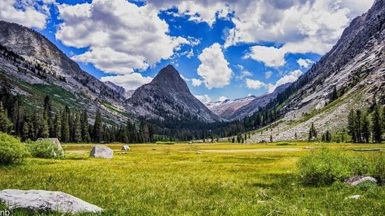
Cloud Canyon
Big Wet Meadow, Cloud Canyon

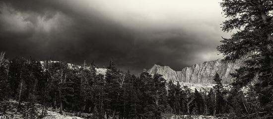
Colby Pass
Peaks around Colby Pass as viewed from near Colby Lake mid-thunderstorm

Jim Sweeney BPL Member
PostedJul 11, 2013 at 3:20 pm

Wouldn't mind a few afternoon thunderstorms on this trip!! (Note to self: be careful what you wish for!)

Jim Sweeney BPL Member
PostedJul 29, 2013 at 6:00 pm

I said "afternoon" thunder showers. (See above)

Made it over Longley Pass (Roads End/Bubbs toward Avalanche Pass/Sphinx Lakes to Sphinx Col/Brewer Lake Basin/South Guard Lake Basin/ Longley) before getting hit with two nights and a day of rain/thunder while I huddled in my insufficient bivy sack at the small lake just below Longley, ~11,800 feet. After first night of rain, some sun the next day so I could dry out, but after second night (rain so heavy I thought it was going to hurt my hearing smacking like gunshot onto the bivy sack), no sun in the morning and more clouds massing.

So I hiked down to Lake Reflection and back on out to Road's End. Many photos, but not sure they're really any good. Will see what I can do in Lightroom.

Spectacular country. Am going to try to go back next week, this time with a Solomid, and do the whole route.

Jim Sweeney BPL Member
PostedJul 29, 2013 at 6:19 pm

Virtually no snow at Longley, & definitely no cornice to worry about.

M G BPL Member
PostedJul 29, 2013 at 6:55 pm

Hoping to reverse that route on my way to Roads End in September. If you get a chance to post any puctures I would love to see them

M G BPL Member
PostedJul 10, 2014 at 5:33 pm

Jim,

I know this is a long shot but would love some pics and a more complete report from your time up in this area last year

Jim Sweeney BPL Member
PostedJul 10, 2014 at 6:57 pm

Thanks for the nudge. Will try to come up with a complete trip report, with pictures, soon, but for now here's a short version.

Acclimated for 3 days in Sequoia, day hikes, then a rest day.

First day of trip to Sphinx Lake at 10.5 k ' via Avalanche pass trail and then offtrail following Sphinx creek. Never feel like I've found the elegant path for this section. This time I blundered around in the brush at the beginning before giving up and taking the south side of the creek.

Second day over Sphinx Col, through Brewer Basin, to lake at the base of South Guard. Great route section, beautiful, mysterious transition from Brewer Lake Basin to South Guard Lake basin.

Third day over Longley Pass — sandy, and a bit of a slog, but not technical –to large lake two or three lakes below Thunder Mtn. Went high too soon in crossing over from the North base of Longley, had to do some climbing. Massive talus in the center of the creek coming down from T mountain. Should have stayed to the left of the creek. (Creek completely buried by the talus).

Fourth day, stayed high to the left in canyon approaching T mountain Col, was way above any ice. Not convinced I took the right exit at the headwall; ground very unstable, chicken feed, some of the moves in the slot that I chose a bit technical, had to clean a bunch of rock. Seemed like it hadn't been used before. Came out of the col 20 feet or so above a broad causeway, leading up to what might have been the proper exit, but that didn't look great either. Descended past a series of beautiful lakes and long slabs to a lake just a little short of the north-south trail in the upper Kern basin. (The northern limit of this trail is Lake South America).

Short 5th day to next campsite, just west of the creek near where the North-South trail bends East ( 1/2 mile + south of junction for the cross-over trail that leads East to the John Muir trail). Snow that night, so had a rest day on the 6th day, waiting for the snow to melt. Visited with the foxtail Pines.

7th day cross-country up to and over the pass left of Milepost mountain, to a lake just below Milepost bowl, above Colby Pass trail.

8th day trying and failing to find the proper approach to what would have been the next pass, Glacier Pass. Eventually gave up, and went over Colby Pass, on trail, to Colby Lake. Pretty lake, nice campsites, but the ground dirty from the charcoal of illegal fires. (If we spread the ashes around afterwards, why then we never really had a fire, did we?)

9th day down Cloud Canyon to Roaring River ranger station, then up Avalanche Pass trail to very park-like region below Avalanche Pass. Roaring River campground completely empty.

Next morning, over Avalanche Pass. Beautiful snow storm, but hands too cold to replace camera battery when needed. Though many other pictures from the trip. Down Avalanche to Bubbs and out to Road's End, where I passed a ranger deep in thought, and thanked him for a great summer.

Every day was cold, the air so clear. Only warm when moving or in my sleeping bag, and even then it was a bit dodgy. Late September.

Viewing 24 posts - 1 through 24 (of 24 total)
Loading...