I love the guy who turtled at 0:35. That’s me on an elk hunt, “Help, I’ve fallen down and I can’t get up!”
That Zodiac at 1:50 is very low in the water. I’m not sure it’s rated for 4 (or 5?) guys plus an elk!
Topic
Become a member to post in the forums.
I love the guy who turtled at 0:35. That’s me on an elk hunt, “Help, I’ve fallen down and I can’t get up!”
That Zodiac at 1:50 is very low in the water. I’m not sure it’s rated for 4 (or 5?) guys plus an elk!
Normally we use the Whaler with the 90 outboard. It had electrical issues, so we blew up the little 8′ raft with the 2.3hp. That got flipped by a williwaw and we couldn’t get the outboard running again so then we were down to oars. The next devolution would have been swimming to shore in survival suits. :^(
Nah, just inflate the stomach and intestines of the elk and use them as water wings.
Yah, there’s a point when you’ve pulled on the starting cord 93 times that you’d have gotten there already if you’d just pulled on the oars 93 times.
I’m forgetting the particulars now, but some guy walked from, I don’t know, Alaska to Norway all in a dry suit. Walked in a dry suit, jumped in the water at each lead, swam in the dry suit to the next bit of ice, wash, rinse, repeat. He lost like 60 pounds.
I just did a 4-day, 70-mile hiking and packrafting trip down the west side of Afognak Island. I started at Port Williams on the south side of Shuyak (the island north of Afognak) and finished in Anton Larsen Bay (on Kodiak, the island south of Afognak). Unlike most of Kodiak, Afognak Island is densely forested. Roosevelt elk roam there and create some amazing trails. The dense forests and vegetation means animals are more difficult to spot and I only saw 4 bears and a single bull elk, but it is beautiful country and quite different from many of my other trips in the archipelago. See it here: Hiking and Packrafting Across Afognak Island
Looks like a very challenging adventure.Do you have a map you could share that shows the route?
Thank for taking the time to post…
Sure. I can also provide a gpx or kml file if that would be helpful.
Here goes:

Phillip your picture explains it to a T. I believe if I was a bit younger I would take you up on this adventure, as this is what I refer as “true packrafting the wilderness”!!
Thanks again and……..
“You don’t get old and stop hiking. You stop hiking and then get old.”
We have a very strong hiking culture here in Kodiak, but not many folks backpack. I can understand why given our weather, terrain, and vegetation, and a lot of people probably don’t even know that there is amazingly hike-able terrain along the road system just beyond the popular trails. In order to offer a backpacking option that is near town and not crazy difficult, I have developed a 38-mile route and attempted to document it in the following video: Kodiak Sidecountry Challenge Route
It may take me awhile, but I intend to do this someday! Thanks.
Cool. I have put together a companion thread on the Kodiak Snow Report website that discusses topics like the best time of year to do the trip, route and bail options, water resources, downloadable .gpx and .kml files, printable maps, and so forth. You can see the info here. (Note: it is the same link that is presented at the end of the video, but I have added a lot of information since I posted the video).
The main idea behind this effort is so that people can get a feel for what backcountry travel on our lovely island is like without committing to chartering a plane into the true hinterlands and then not having any recourse other than an air taxi pickup if the need arises.
I just got back from an 8-day trip to the west side of Kodiak Island to help an archaeologist friend do a prehistoric site survey of 2 large bays. We used our own personal gear which in this case is a mix of light (cuben shelter, down bags, and titanium wood stove) and not-so-light (inflatable kayaks, plastic storage barrels, and heavy food items). The weather was quite nice for early spring in the Gulf of Alaska. We do these surveys before the vegetation goes crazy because we are looking for shallow depressions in the ground indicating house pits (the Alutiiq lived in ‘barabaras’ which are semi-subterranean sod huts) and middens (discarded charcoal, shell, bone, worked stone, etc) which will soon be obscured by tall grass. All the critters were out enjoying spring except for the Sitka Blacktail deer which suffered an absolutely epic winter kill this year. In 8 days we only counted 3 live deer. There were carcasses absolutely everywhere. So grim. Anyway, despite the fact that life here is still kinda/sorta normal, it was nice to get out into the field for a bit.
See the video here: 8 Days in Zachar and Spiridon bays.
For my second trip of the season I did a 5-day packrating/hiking loop on the NW corner of Afognak Island which is part of the Kodiak National Wildlife Refuge. I took the mail plane in and out of Port William, an old herring cannery on the south side of Shuyak Island. The NW corner of Afognak is one of the most beautiful places in the Kodiak Archipelago. See if you don’t agree: Packrafting and Hiking the KNWR on Afognak Island

Awesome video as always Philip. You live in a beautiful place and do some amazing trips. Your videos are always so professional looking, thank you for sharing them with us.
^^ditto! I really enjoy your videos .
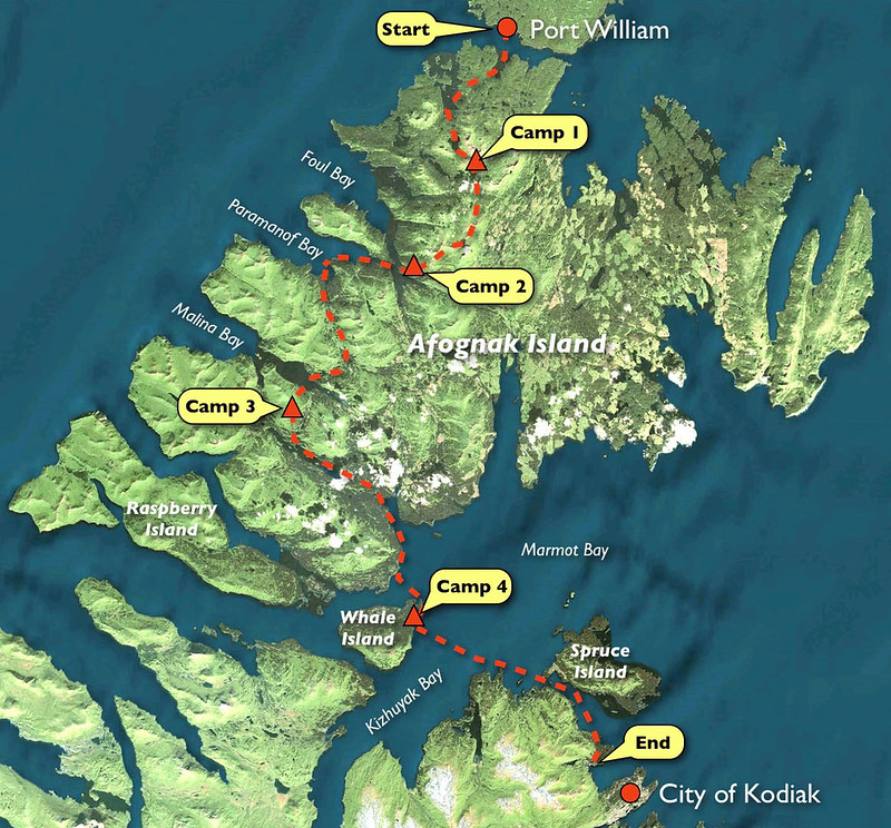
I just did a 5-day, 75-mile trip starting at Port William on Shuyak Island and traveling down western Afognak Island back to the city of Kodiak. I did it over the 4th of July weekend which ended up getting a bit damp the last day and a half. But the Afognak high country in the KNWR lands are beautiful and I ran into well over 100 Roosevelt elk along the way. As usual for Afognak, I didn’t see many bears due to the dense forest.
You can see it here on Vimeo: Crossing the Afognak Island High Country
A rough map of my trip from the video:
Awesome video! I love the trips you pull off. Thanks for sharing!
Logan
Philip – Is everything OK there in Kodiak? I heard you had a pretty good earthquake near you.
The earthquake was offshore of a lightly populated portion of the Alaska Peninsula, about 265 miles (426 km) from Kodiak. Reports from Kodiak show very light shaking of MMI II.
 But several people reported considerably more damage:

No major tsunami expected; some local sea level changes might be seen.
Hope everyone is OK.
— Rex
I appreciate the concerns, but I was actually up in the mountains doing another solo trip in the interior of the island during the event in question (where I noticed nothing) and returned to a totally normal scene in town. Or, what qualifies as ‘normal’ these days. In fact, seeing this was my first news of the quake.
New trip video soon…
Looks like the action was around the Shumagin Islands:

Glad you weren’t impacted Philip. I look forward to your video!
As promised…
This video depicts a 3-day, 45-mile packrafting and hiking trip from the village of Port Lions back to Kodiak. I took the mail plane to Port Lions to avoid westerly winds forecasted for Kizhuyak Bay (which never really materialized). I paddled down the east shore of Kizhuyak to the KEA Terror Lake hydroelectric project service road. I walked up the haul road until it entered the alpine at which point I left the road and traveled south cross-country along the ridge to the Widgeon Bowl, eponymous for the Grumman Widgeon wrecked there. I then continued over the southern flank of Crown Mountain and the 3 subsequent ridges until finally descending into Bell Flats on the 3rd day. Kodiak has some lovely high country and it is possible to do longer trips that avoid brush if you plan well.
See it here: Packrafting and Hiking from Port Lions to Kodiak
And the map from the video:

More aimless(?) wandering…
I just did a 4-day, 50-mile counter-clockwise lap around Shuyak Island on the northern edge of the Kodiak Archipelago. I took the mail plane in and out of Port William on the south side of Shuyak Island and used the outer coast for travel when the prevailing southwesterly winds allowed. Shuyak Island offers one of the most unique and well-suited destinations for packrafting in coastal Alaska that I have encountered. It is characterized by a myriad of bays, inlets, tidal sloughs, and lakes that make travel across the island by raft easy. And when the paddling is a bother because of wind, the cross-country hiking is nothing short of wonderful in the interior Sitka spruce forest or on the outer tundra-clad capes. The only wrinkle was that on the final morning of the trip Island Air let the caretaker at Port William know they were coming earlier than scheduled. He was nice enough to cruise out the coast looking for me in his skiff, proving once again, “it’s not what you know, but who you know, that counts…” lol.
See it here: Shuyak Island 2020 on Vimeo.
The map from the video:

I almost forgot to post this, perhaps my last* backpacking trip of the season: Overnight on Elbow Mountain on Vimeo.

*Excluding elk hunting.
Thank You.
Thank You.
Thank You.
I look forward to next years adventures.
Become a member to post in the forums.
 33% off home freeze dryersMore nutritious, better flavor, custom meals.
 Loading...