Living in California, it’s easy to get complacent and only go backpacking when the sun is shining and the birds are chirping. Following Dave’s excellent blog and trip reports from the likes of Ike Jutkowitz, Andy Duncan and others has made me realize that not only can more challenging conditions provide a great learning experience & sense of mastery of outdoor skills, being in the wilderness in all conditions can be lots of fun too. The Bob Marshall Wilderness Open seemed like a fantastic way to get some more experience having fun in “bad weather” with the side benefit of meeting some of the forum’s more interesting personalities. I somehow managed to convince Chris Steutterman that this whole thing was a good idea too, and we booked our plane tickets to Kalispell back in February. Much planning ensued, and the genius in an open ended event in uncertain conditions became apparent – your fears are quickly revealed when forced to stare at a blank slate. How big are the river crossings going to be? Do we need snowshoes? Is it going to be 33F and raining for days at a time? Will I be able to get a fire going if everything is soaked? Am I going to get eaten by a grizzly bear, or perhaps even by Dave Chenault himself?

Fresh Chenault tracks deep in the backcountry.
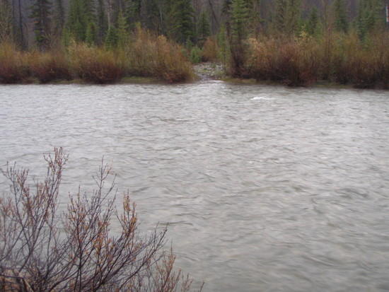
Since I can count the number of times I’ve been rained on backpacking in the last 5 years on one hand, it seemed prudent to do a few training trips beforehand to prepare for spring in Montana. Despite our best efforts, we never did see any rain and the worst we could do was find some rotten snow to posthole through and a few medium-sized river crossings, but the mileage was there and we were pretty confident that we could pull this thing off. We planned a route that followed the South Fork of the Sun River from the trailhead to Gibson Reservoir, where we then followed the spectacular North Fork of the Sun all the way to its headwaters at Sun River Pass (6400′). Then, once into the drainage of the Middle Fork of the Flathead River, we would follow the Middle Fork all the way to the finish at Bear Creek. The course this year was long and committing for hikers, with the hardest river crossings coming near the end with few attractive options for bailing.
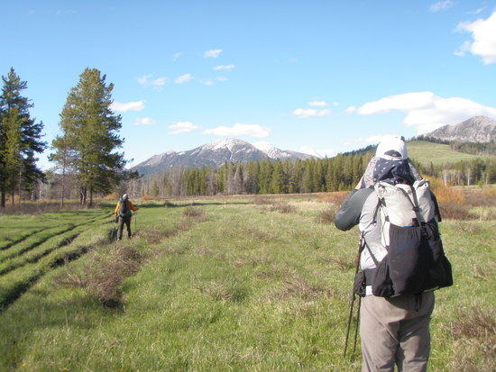
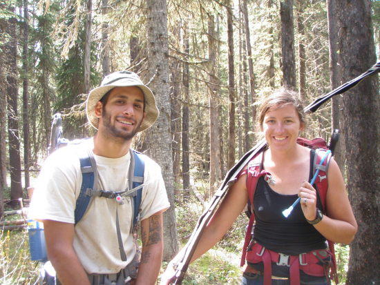
After catching a ride with Cyrus & Kate to the start and an enjoyable evening hanging out with the other participants, we awoke to beautiful weather on Saturday morning. During the first few miles our pace lined up well with John St Laurent, who had planned a similar itinerary to Chris and I. We ended up spending almost the entire trip with John, which turned out to be a very effective partnership. The first two days were fast and easy with lots of beautiful scenery to keep our cameras clicking away. Perfect weather combined with a river forecast for a dip in flows on late Sunday kept us moving quickly, though – we wanted to take advantage of the lower flows to get across the more difficult crossings. Based on our planning, the biggest crossings would be Strawberry Creek, Lodgepole Creek and Granite Creek with a few other smaller but faster crossings thrown in. Strawberry looked to be by far the biggest, and so we hauled ass to get across it by Sunday evening before the flows came back up.

Pre-race safety meeting.

The beautiful valley of the South Fork of the Sun River.

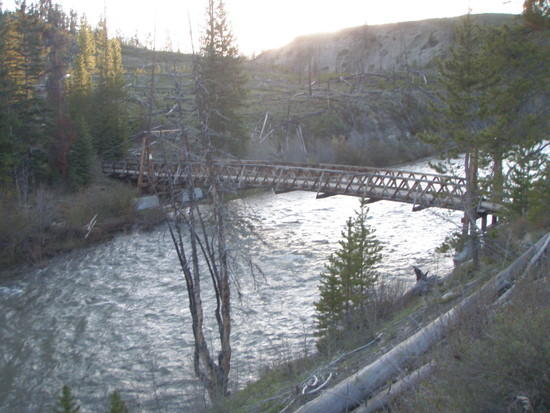
Packbridge over the Sun River at Gibson Reservoir.

Hiking up to Arsenic Creek near Gibson Reservoir to avoid private property boundaries.
We spent the first night at the packbridge near Gates Park after 27 miles of easy walking. There wasn’t much in the way of blowdowns despite miles of burned forest, and the long daylight hours (sunrise around 5:45AM and sunset around 9:45PM) made it easy to rack up the miles. That night was pretty cold though not freezing, and we continued up the North Fork of the Sun to what was the visual highlight of the entire journey. The terrain opened up into beautiful prairie and we got some great views of the Chinese Wall and the Continental Divide. Shortly after Lick Creek we started seeing Dave’s footprints which couldn’t have been more than a few hours old and we felt like we were on the right track. There was some blowdown on the way to Sun River Pass, but the sun was shining and we still managed to make good time. Somewhere close to the pass John’s achilles started acting up, and we lost him at a confusing intersection right below the pass. Wanting to cross Strawberry Creek before the flows came back up, Chris and I pressed on and made the crossing at around 7:30PM that night.

Beautiful terrain on the North Fork of the Sun River.

Feeling good.

Biggs Creek

Anyone care to speculate what animal made this? Big coyote? We hadn’t seen other human or canine footprints for hours.

Camp and a nice fire to dry stuff out near Gates Park.

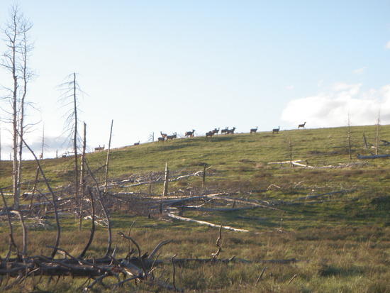
Elk herd near Sun River Pass. John said he counted 45.

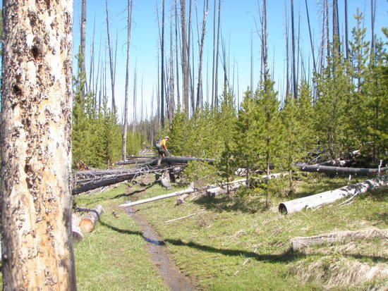
Few miles of blowdown near the pass.

We made Sun River Pass around 3PM Sunday. A growing thunderstorm reminded us that it was Memorial Day weekend.
Fortunately Strawberry Creek turned out to be no challenge at all, despite our anxiety while planning the trip. It was wide, but never more than about knee deep and the current was very slow. I felt a great sense of relief when I saw the crossing, because it meant we wouldn’t have to bail out via an alternate route that we had planned over Badger Pass. Dave’s footprints went into the water but never came out the other side, so we figured that he had put in his raft there and that from there on he would be way ahead of us. We made the crossing at about 6PM and continued on down the trail to Gooseberry Park ranger cabin where we called it an early night at 8PM. We hoped John would catch up to us, but we didn’t end up seeing him until the next day. The guard station was a nice treat, with drop-dead gorgeous views up and downriver as well as a sheltered overhang. We threw our pads down on the bone-dry porch and enjoyed the rest of the evening as a light drizzle misted the valley. We celebrated making the Strawberry crossing with some dehydrated birthday cake and Nutella my wife had made for us. We would later chuckle at our premature celebrations… it turned out the Bob wasn’t done with us yet.

Strawberry Creek ford.

New scenery as we follow the Middle Fork of the Flathead.

Gooseberry Guard Station, our camp for the night.

Clearing storm over the Middle Fork. This spot definitely made me feel like I was on vacation and not just trying to go fast.
The storm mostly cleared up overnight, and we were treated to killer views down the Middle Fork through the remaining low-hanging mist. The next two crossings, Cox Creek and Callbick Creek, were uneventful and the blowdown was mostly gone after Gooseberry Park. We ran into a trail crew early in the morning, and got some stream beta from them and thanked them for making our lives easier. We made good time to the Schafer airstrip.


Busy day at Schafer.
It was at this point that things got interesting. We made it to the confluence of Lodgepole Creek and the Middle Fork around 3PM. Somewhere after Schafer we had picked up Greg Gressel’s footprints after he forded the Middle Fork, and his footprints disappeared straight into Lodgepole Creek in front of us. However, the creek was a mess of boiling water with waves and some big rocks in the short distance between the ford and when you would get forcefully ejected into the Middle Fork. Had Greg really crossed here? Had the water risen significantly overnight? One look at the crossing and we both knew we wouldn’t be fording the creek there. We walked about 200 yards upstream to where our map showed a second crossing, and this one looked more reasonable. However, most of the flow went through a deep channel on the far side next to an eroding cliff bank. We sealed up our packs and found some stout branches (in order to not lose our hiking poles if we had to swim) and I made it about halfway across, where the main channel of the creek got much deeper and faster. It was clear to me that if I went any further, I’d be swimming with a poor exit on the far side. When planning the trip, Chris and I had decided that we would be pretty conservative when it came to the river crossings – neither of us wanted to voluntarily swim.
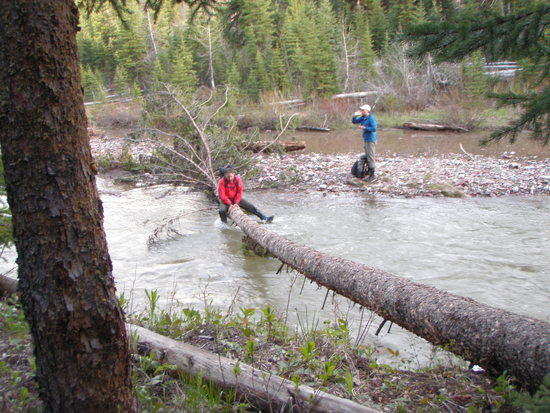
We backtracked to the shore, and upon consulting the map we saw that there was another crossing a few miles upstream that might offer an easier opportunity. After a futile attempt to take a straight line off trail through the downed trees, we cut back to the trail and walked the 2 miles or so to the upper crossing. It was a little better – wider (about 50 feet wide here) and with no deep channel – but it was still waist deep and forceful. I walked about 10 feet out into the creek again, and it became difficult to keep my balance as the water came up to my thighs. With deeper water ahead, I retreated back to the shore and we considered our options. It was around this time that the Bob Marshall Wilderness felt like it was earning the capital “W”. Just as we were beginning to consider the long walk around via Schafer, John appeared out of the woods. His Achilles was still bothering him, but he was making pretty good time on the trail anyway. He too took an exploratory trip out into the creek, and decided that it would probably require swimming and that the steep riverbank and willows on the far side would make a poor exit. John asked if we had looked downstream, and I realized it hadn’t even occured to me to look that way. When we were off-trail, we got a good look at the river and didn’t see any easy way across from up on the hill, so I figured it was futile. But just out of sight downstream of the crossing, a lone tree had fallen across the creek and completely bridged the gap. It was too narrow to walk across – about 8″ on our side of the river – so we all ungracefully butt-scooched across, saving ourselves 25+ miles of detour in the process. By this point we had wasted about 3.5 hours looking around for a crossing, and it was getting late, so we camped shortly afterwards, grateful to be across the creek.

Lodgepole Creek.

A mile of ‘shwacking stood between us and the Middle Fork trail in the morning. We were grateful to have Chris’s GPS for this section.

The Middle Fork was especially beautiful when we got back to it, with big gravel bars covered in aspen and wildflowers.
At this point we figured we might have more challenge left than we had originally thought when we made it over Strawberry Creek. The Granite Creek crossing was up ahead, and it looked like it drained a similar basin to Lodgepole but had a much steeper gradient. Fortunately when we got there, it wasn’t too bad and we found an easy spot where the current split in two around a gravel bar. It was never more than knee deep and wasn’t pushy. There was a nice gravel bar on the far side, and we took an extended lunch break to refuel and dry our stuff out around a small fire. Doing the math, it was about 11:30AM and we had roughly 20 miles to the trailhead – despite sore legs we figured we were home free & would be finished before dark that night.

John at the Granite Creek crossing.

Lunch break on the far side.
The Bob wasn’t quite done with us yet though. We chugged along for a few more miles along the Middle Fork, when the noise from the water got a little louder and I looked down the hill. “That’s odd. Why does it look like the Middle Fork is flowing backwards?” I wondered. A quick consult of the map showed that the raging torrent below us was in fact Twentyfive Mile Creek, which we had discounted as being a relatively easy crossing due to having a smaller drainage than any of the other big crossings we had to do. But we had failed to notice that Twentyfive Mile drops about 300 feet in the last 1/2 mile to the Middle Fork, and the trail crossing looked to be waist deep and faster than any of the others we had seen. I noticed that about a half mile upstream, the river leveled out and only dropped about 30 feet in a similar distance, so we decided to head upstream until we could find a safer way across. This turned out to be easier said than done, and after a few hundred yards of following an old trail we encountered many downed trees and thick brush. It took us roughly an hour and 15 minutes to travel the half mile upstream, and I think we lost some dignity (as well as one of Chris’s socks) in the process. But once we got to the flatter part, the crossing was again wider and slower and presented no problems at all. Thankfully there was a trail on the north side, so the 1/2 mile return trip took just a few minutes and we were back on track.
At this point we were done declaring victory until we were actually standing in the parking lot, and the words of the trail crew came back to memory. They had mentioned Spruce Creek, which is pretty small and just 4 miles from the car, as being a difficult crossing when they went through there 2 weeks ago, and had mentioned that they had to crawl across a log to get across it safely. We spent the next 3 hours hiking through Spruce Park in the dark with a sense of dread that we would get shut down by that thing at the bitter end, but when we got there it turned out to be not even knee deep. I guess the water there was a lot higher two weeks ago when the Flathead was at flood stage. The final 4 miles back to the car was a bit of a blur, and we made it out just after 1AM to the eerie and surreal sounds of a freight train chugging over Marias Pass.

John and Andrew on the far side of Spruce Creek.
Overall it was a great trip, and the uncertainty up til the very end made for an engaging and educational experience. I learned a lot, both preparing for the Open and from the Open itself, and I certainly feel like a more capable hiker as a result. I’ve learned that you can enjoy yourself outside 365 days a year, and that there is no such thing as the “off season”. It was great hiking with Chris and John, and surprisingly despite the obstacles I think almost all of this trip was Type I fun. Dave and Meredith, thanks for your hospitality in taking us out in Kalispell, you two seem like good people. And of course, thanks for organizing the Open – I suspect I’ll be back again next year.