Topic

Sierra Snowshoe :: Feb 2013

  • This topic is empty.
Viewing 25 posts - 26 through 50 (of 72 total)
Jacob D BPL Member
PostedJan 30, 2013 at 4:24 pm

Hey gang.

To recap for those who may not have have noticed – I updated the original post a few days ago to reflect popular opinion on the trip location and dates.

Scott's Lake is outside of both Desolation and Mokelumne wilderness; Tahoe Basin Management is responsible for the area and they confirmed all we need is a campfire permit. The bad news is, the parking lot at the trailhead is not plowed in the winter and might not be much more than a turnout. The Ranger indicated there is a wide shoulder there which is normally used for chain up and *IF* the roads are not under chain control at the time, overnight parking is allowed. Ranger said we can confirm this with the highway patrol.

My guide book says use the parking lot, other info online says park along the highway down the road from the trailhead. Not sure how I'm feeling about the parking, if snow is in the forecast it could become an issue.

Thoughts?

PostedJan 30, 2013 at 6:56 pm

David, I think I won't risk it on whether the boots fit or not. It would suck to get out there and find out they don't. Thanks for the offer to share, though.

Jacob, it sounds risky to depend on the forecast to not get out cars towed – I assume that's what would happen if we were parked there and they started chain control. If there isn't any other parking than the chain control area, that might be a good reason to go to Devils Dancefloor…

Jacob D BPL Member
PostedJan 30, 2013 at 7:39 pm

Andrew – agreed. I think I'll try to speak with the highway patrol and if I can't get this sorted tomorrow, maybe a change of location is in order.

Bob Gross BPL Member
PostedJan 30, 2013 at 8:58 pm

Peter Grubb Hut has a Sno-Park lot near Boreal. You just need to get a permit.

–B.G.–

Philip Kovacik BPL Member
PostedJan 30, 2013 at 10:23 pm

Hey Ya'll,

I called up there today and the first available at Peter Grub is 3/30 for 4 people…sorry to be the bearer of bad tidings.

PostedJan 31, 2013 at 5:58 am

FWIW – I'm pretty sure we can camp out anywhere in the valley around the hut. Which I would rather do anyway.

But it's just a suggestion….

Bob Gross BPL Member
PostedJan 31, 2013 at 12:18 pm

"I'm pretty sure we can camp out anywhere in the valley around the hut."

Yes. I've seen people camping about 75 yards northwest of the hut.

Some people hike in there expecting to be a squatter at the hut. One guy had been living in the hut for more than two months, and he burned up all of the firewood. The next group with reservations got a harsh surprise.

I was staying in the hut one time when two people came to the door. They were snow camping and one person was getting hypothermic. So, we sat that person down next to the wood stove and served them hot drinks until they were OK. Then they returned to their camp out in the woods.

–B.G.–

Richard Niemi BPL Member
PostedJan 31, 2013 at 7:54 pm

I'm fine with wherever we end up going. My plan is to come up on Friday and use skis. The more skiers the bigger my grin will be.

Eric Lundquist BPL Member
PostedFeb 5, 2013 at 12:14 pm

Jacob passed the following information on to me to post when BPL came back online.

"CHP…said that the turnout should be plowed, the parking lot (where my book says to park) is not plowed and is closed. Parking in the turnout or along the highway is ok as long as not signed for no parking *HOWEVER* if snow removal conditions occur it's possible that our vehicles may be towed. He also mentioned they've had some break in's out there when vehicles have been parked overnight. He recommended parking in Christmas Valley, which is about 2 miles up the road from the trailhead, or parking at the sno park in Hope Valley, which makes for a shorter but steeper hike to Scott's Lake in avalanche prone terrarin (from what I've read). That sounds less fun.

So, if the weather looks clear we should be good, other than some break in risk.

If the weather is uncertain, or snowing we'd have to park 2 miles away, and hope we find parking.

It might not be the best idea for a group trip unless everyone is on board with the risks."

I believe Jacob will respond later this evening. I mentioned to him that we could still plan for the Big Meadow to Scott's Lake route pending weather and the number of interested parties. If there is greater interest and/or the weather forecast calls for snow, we should probably look at doing the trip out of the Sno-Park lot near Donner and choosing a camp near Peter Grubb hut.

Richard Niemi BPL Member
PostedFeb 5, 2013 at 12:25 pm

If we need an alternative Peter Grubb sounds good. Another location in this general area is Echo Lake area which has a sno-park.

Jacob D BPL Member
PostedFeb 5, 2013 at 7:48 pm

Eric, thanks for posting that for me. I just got back in… long day.

Richard, I'd prefer Grubb Hut over Echo Lake area (my usual stomping grounds up there).

I'm ok with changing the plan up to hiking out to the Grubb Hut and camping around there somewhere if that's the popular vote. I am still interested in Big Meadow / Scott's Lake / Waterhouse Peak but I don't want the parking issues to weigh on anyone. The weather shouldn't be too hard to call a few days in advance.

PostedFeb 9, 2013 at 9:10 am

Hey All –

Just thought I would post up this thread and see what's up.

Anything new?

Everyone still in?

Jacob D BPL Member
PostedFeb 10, 2013 at 4:46 pm

I'm still in. I dont think anything has changed. I like Eric's suggestion of sticking to the plan and if we expect snow change to the Grubb Hut vicinity.

PostedFeb 12, 2013 at 3:46 pm

I'm in for sure, I'm psyched!

I'm toying with the idea of leaving the Bay Area at 10:00 pm Friday and trailhead camping. It's a full moon so it might be fun to ski in a ways.

But more likely I'll leave early Saturday.

Anyone else confirmed for Saturday morning and want to ride together? If the roads are clear I have a car with good MPG.

Dave

Jacob D BPL Member
PostedFeb 13, 2013 at 7:58 am

David, not sure what time I'll be leaving at but I think Friday afternoon sometime. Sort of depends on whether anyone wants to car pool and how their schedules look.

I'm looking at the 10 day forecast and there isn't much snow forecasted between now and Friday the 22nd, of course things can change so we'll just keep an eye on it. If it's clear like this, then we shouldn't have any issues parking in the large turnout where the Tahoe Rim Trail meets HWY 89.

Jacob D BPL Member
PostedFeb 17, 2013 at 8:46 pm

Can we get a count of who is in for this?

I think right now the only confirmed people we have are:

– David L
– David W
– Jacob D

Chris S BPL Member
PostedFeb 18, 2013 at 2:37 pm

Julie and I are 50/50 right now. If the conditions are good, we will probably be downhill skiing this weekend since we haven't been able to use our season passes very much this year. Otherwise, we will plan to join in on this trip. I should know for sure in a couple days.

Marc Eldridge BPL Member
PostedFeb 18, 2013 at 8:03 pm

Me and Rick are in. Looks like there won't be any snow this weekend so we will be heading out of 89 and TRT. Do you have the coordinates of this location?

PostedFeb 18, 2013 at 8:43 pm

Weather.com has it at a 50% chance and the NOAA predicts a "slight chance" of snow showers Saturday.

Does this potentially affect us for parking? If they end up having to plow the road they might tow our vehicles?

Also, and this is just food for thought, the new snow expected to fall this week on top of the current snowpack will result in an increase in the avalanche hazard. I definitely don't know enough about it to assess the risk by looking at a topo, I know just enough to be wary. It appears on Hillmap.com that the valley at the foot of Waterhouse is big enough for us to avoid dangerous slopes except possibly at the very beginning.

Not trying to freak anyone out, just putting it out there.

Jay Wilkerson BPL Member
PostedFeb 18, 2013 at 9:38 pm

If the weather does not work out for you Eskimos I am going back to Henry Coe and going to Coit Lake from the Headquarters a groovy 26 mile round trip. I was in Tahoe this past weekend and the conditions were pretty ideal for some snow shoeing which I did at Sugar Bowl and around the lake on Soda Springs Rd. If any of you abominable snow men have 2ND thoughts–well see ya there bright and early.

Jacob D BPL Member
PostedFeb 19, 2013 at 7:46 am

Confirmed Attending
– David L
– David W
– Jacob D
– Mark E
– Rick E

Location
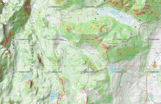
*IF* we stick with Scotts Lake, I don't have a coord, USGS Topo = Freel Peak
That will get you most of the area except the very beginning which is around/near the TRT / HWY 89 junction.

*See next part…

Concerns
Parking – We can watch the weather and call this Weds evening or Thur morning if that works for everyone. If snow is a concern (as in, maybe leading to our vehicles being towed!) we can change our destination to the Grubb Hut area, no big deal.

Avy Danger – It's always good to be aware of the conditions. We'll be making our way along the West / South West aspects of Waterhouse Peak and greater area. Wind loading is much less of a factor on those aspects. SAC has the avy danger for today (heavy snow) increasing from low to moderate on S/SW aspects below tree line. We'll be well below tree line the entire time (except anyone who still wants to bag the peak). The slopes are forested most of the way up, and the South Side of Scott's Lake is relatively flat and away from the slopes on either side – my personal assessment – I feel ok with it.

Weather – Depending on which forecast you read, there may or may not be snow. Low temps in the teens to low 20's. Some wind. Prepare accordingly.

PostedFeb 19, 2013 at 9:03 am

Ellen and I are still interested. We just did a day hike up past the Grubb Hut this weekend though, so we will probably go somewhere new if the weather turns out to be too risky to park at Scotts Lake.

Eric Lundquist BPL Member
PostedFeb 19, 2013 at 1:01 pm

Jacob,

Put me down for attending. Unless we're "hiking" in as a group, I'll be coming up early Saturday morning on snowshoes.

Approximate location of Scott's Lake (38.7657, -119.9695 @ 8063 ft) The slopes don't appear steep enough to cause me concern for avy danger, especially as they're mostly southern facing slopes. Below is a slope map of the area, Yellow = 28-34*, Red = 35-45*.
Big meadow - Slope Map

EDIT: Looks like we're almost on the full moon for this trip.

Viewing 25 posts - 26 through 50 (of 72 total)
Loading...